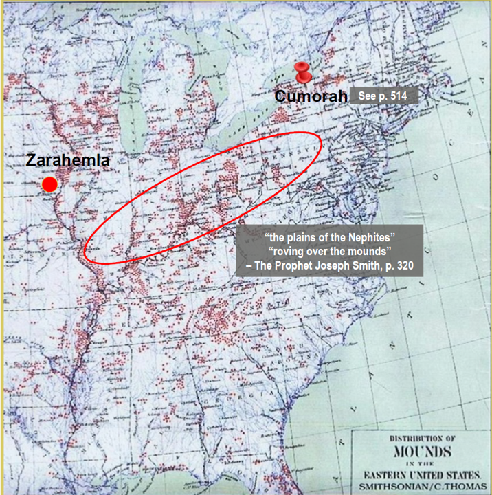
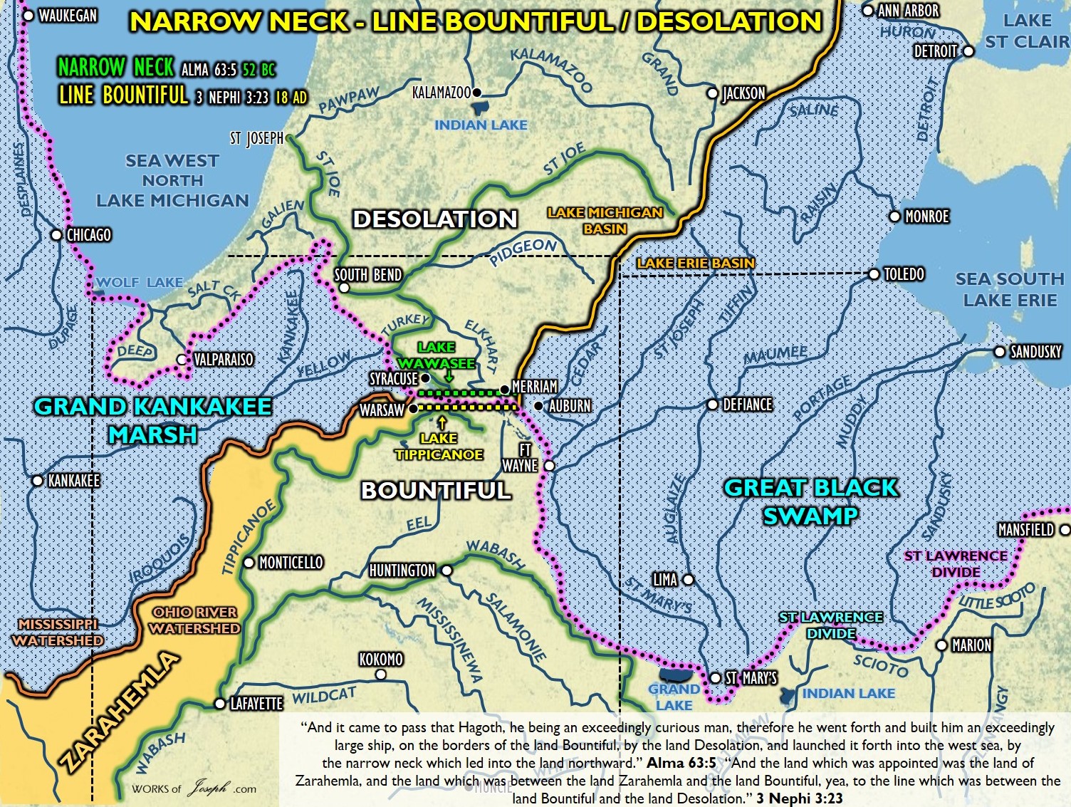
Indiana is a likely location of the Narrow Neck, [Not the Narrow Neck of Land which is the Niagara Peninsula in Ether 10:20], spoken of in Alma 63:5, near the southern end of Lake Michigan, and in upper Indiana is also the possible location of Lachoneus (see 3 Nephi 3:11–13, 22–25) when he gathered his armies to prepare for a fight in the center of the land with the Lamanites. “And he caused that fortifications should be built round about them, and the strength thereof should be exceedingly great.” 3 Nephi 3:14 See map below.

An 1818 Palmyra newspaper said, “The author of this interesting and valuable work, in speaking of the antiquities of the state of Indiana that now exist near Vincennes, County of Knox, says that “On the hills, two miles east of the town, are three large mounds; and others are frequently met with on the prairies, and upland, from White River to the head of the Wabash. They are in every respect similar to those in Franklin County, already described.
The French have a tradition, that an exterminating battle was fought in the beginning of the last century, on the ground where Fort Harrison now stands, between the Indians living on the Mississippi, and those of the Wabash. [This area in present day Indiana seems to fit nicely the area of the Land Zarahemla and the Land Bountiful in the Book of Mormon]
The bone of contention was the lands lying between those rivers, which both parties claimed. There were about 1000 warriors on each side. The condition of the fight was, that the victors should possess the lands in dispute. The grandeur of the prize was peculiarly calculated to inflame the ardor of savage minds. The contest commenced about sunrise. Both parties fought desperately. The Wabash warriors came off conquerors, having seven men left alive at sunset, and their adversaries but five. The mounds are still to be seen where it is said the slain were buried.” Palmyra Register, 21 January 1818 Extract from the Western Gazeteer.

Top Ten Native American Indian Burial Mounds & Earthworks in Indiana
“These are the top ten Indian mounds and earthworks that can still be visited in Indiana that were constructed by the Allegewi (Adena) and Hopewell (a confederation of Sioux, Iroquois Cherokee and Allegewi). Some of the mound sites in Northern Indiana could date as early as 1500 B.C. The mounds and earthworks in the central and southern part of Indiana were constructed from 500 B.C. – 500 A.D. There are close to 100 burial mound and earthworks sites that can still survive in Indiana, of these only 2 are recognized as “Historic Sites.” One of which is, Mounds State Park that continues to be excavated and destroyed by university archaeologist. If you’re a tourist in Indiana, all of these sites are in jeopardy of being destroyed.
1. Number One Ancient Tourist Attraction in Indiana. Mounds State Park, Henge Complex in Anderson Indian
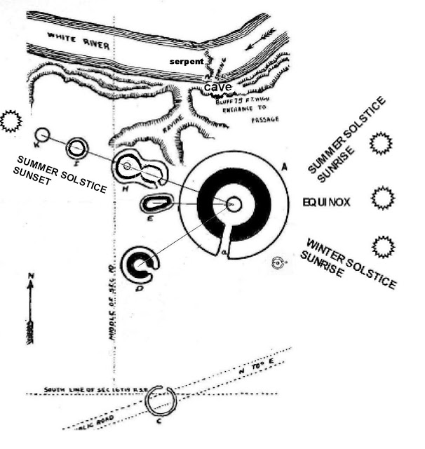
The burial mound in the center platform of the large henge marked the solstices for 2000 years before being destroyed by Indiana University archaeologists. A charge of a few dollars is required to enter Mounds State Park, but the tour of the mounds and earthworks is worth the price. Mounds State Park, despite the destruction by Indiana University archaeologists is one of the best preserved henge sites in the Ohio Valley. Mounds State Park, does not have all of the mounds and earthworks sites listed on their map. Discover the “lost” earthworks with “The Nephilim Chronicles: A Travel Guide to the Ancient Ruins in the Ohio Valley.”

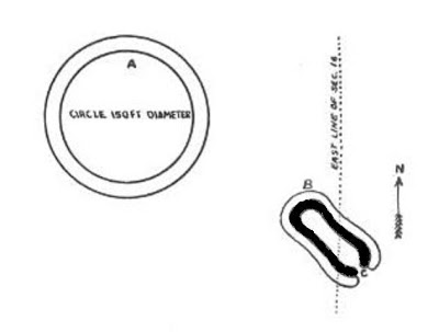
Largest Henge of the southern group at Mounds State Park. The undulations in the outer wall are symbolic of the serpent wrapped around the central circle that was symbolic of the sun. The earthwork complex was a combination of solar and Earth Mother worship. Before touring Mounds State Park, learning of the symbolism of the ancient earthworks and how they were dedicated to the Sun god and the Earth Mother will enhance your visit.
Find out the directions to Mounds State Parks “Lost Henge” This is the site, park officials don’t want you to know about.
2. Serpent Mound near Holton, Indiana
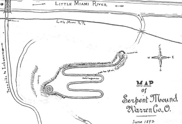
Many people have toured to the famous serpent mound in Ohio, but did you know that Indiana has a serpent mound just as large? Above, an identical serpent mound as that in Indiana was mapped in Warren County, Ohio. If you are touring southeast Indiana, the serpent mound located near Holton, Indiana is a must see!

Indiana’s Serpent Mound undulated back and forth like the previous diagram. Despite the tens of thousands of people that visit Ohio Serpent mound, Indiana does not even recognize this ancient treasure as an historic spot.
3. Henge Complex near New Castle, Indiana
Traveling to Indianapolis? This historic site is an hour’s drive. This ancient tourist treasure is not recognized as a historic site in Indiana, despite being constructed over 2000 years ago.

The photo is a burial mound (#1 on map) in the distance and a the outer wall of thesmall henge ( #2 on map). This historic treasure has had a lot of damage done by Ball State University archaeologists, who have obliterated mound Number “1. A solar alignment of the mounds occurs every equinox. City officials have moved to not allow University archaeologist to continue to destroy this potential, popular tourist attraction.
4. Iroquois, Horseshoe Shaped Fort, Near Fort Wayne
The wall of the Iroquois Fort can still be seen near Fort Wayne, Indiana. If you are a tourist in Fort Wayne, this site has not been opened to the public, yet.

Three of these horseshoe shaped fort were constructed by the early Iroquois along the Maumee from Fort Wayne to Toledo. One of Indiana’s few Native American historic sites is not recognized, nor deemed worth saving.
5. An Iroquois Circular fort near Ashley, Indiana

A circular Iroquois fortification is located near Ashley, Indiana. This potential tourist attraction is also not recognized by the State. This ancient site is on private property but could be opened as a tourist attraction in the future.
6. Henge Complex near Cambridge City, Indiana

Henge complex at Cambridge City, Indiana. The northern Henge was aligned to the summer solstice sunrise with the lower aligned to the equinox sunrise. One of Indiana’s best historical sites. If you are looking for things to do Indianapolis, this site is only an hour away, but has not been opened to the public, yet.
This Adena Henge constructed in 200 B.C. is the same size as the one in Anderson, Indiana. It is currently being plowed and slowly over time, destroyed.
7. Large Henge in Strawtown, Indiana
HengeHenge, near Strawtown was constructed by the ancient Hopewell Confederacy. This henge was constructed by the Oto Sioux Indians about 2000 year ago.
8. HengeHenge, near Yorktown, Indiana

Henge near Yorktown, Indiana on private land. The Henge site at Yorktown, Mounds State Park, New Castle and Cambridge City are all about 20 miles apart.
9. Subterranean Oval Stone enclosure near LaFountain, Indiana
The purpose of this stone subterranean enclosure remains a mystery. It is located near the 1812 Mississenewa Battle Ground, but is much older than the short Miami Indian occupation of northern Indiana.
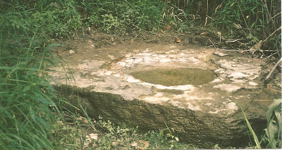
A sacred stone bowl with a natural spring that flows into it along the Mississenwa River. This site is on public land near the subterranean stone work.
10. Winchester, Indiana Earthwork

Winchester, Indiana work that measured 1320 X 1080 feet. Only a few remnants still exist of this possible tourist attraction.
All sites are listed here along with another 75 in Indiana and a total of 222 burial mounds and earthworks in Ohio, West Virginia, Kentucky and Michigan.” Indiana Tourism: Top Ten Native American Indian Burial Mounds and Earthworks in Indiana

There is an extraordinary amount of evidence of ancient mounds and earthworks all over the Heartland of North America. It makes sense that the Book of Mormon indeed began in this sacred land. Elder Perry said, “The United States is the promised land foretold in the Book of Mormon—a place where divine guidance directed inspired men to create the conditions necessary for the Restoration of the gospel of Jesus Christ.” Elder L. Tom Perry Ensign Dec. 2012.
Early Native American Indian Mound Builders in Hamilton County, Indiana
October 5, 2011 EARLY NATIVE AMERICAN INDIANS HAMILTON COUNTY, INDIANA INDIAN MOUNDS AND EARTHWORKS

Historic map left showing the locations of burial mounds and Earthworks in Hamilton County, Indiana
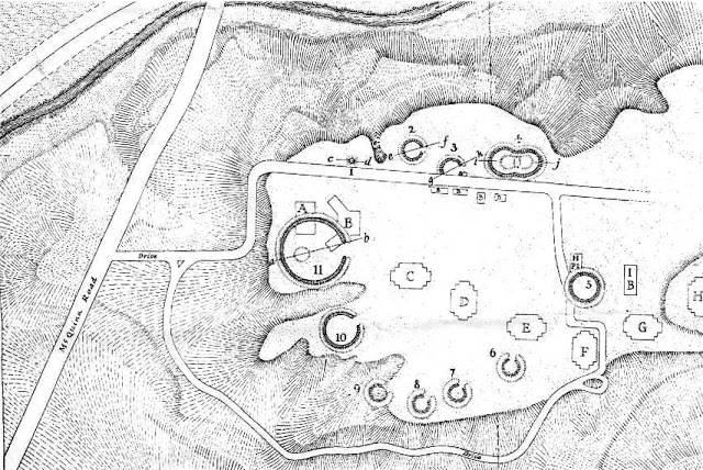
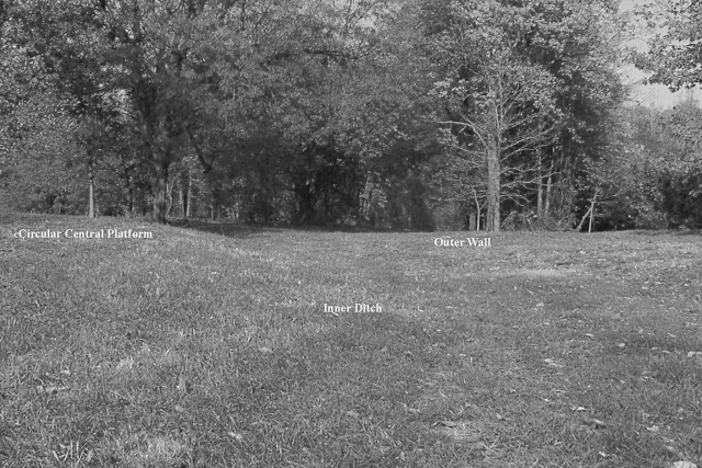
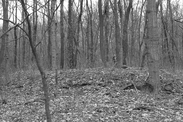
Indiana Department of Geology and Natural History (Fourteenth Annual Report), 1884But Strawtown has an antiquity evidently higher than the days of the Delaware Indians. The mound builders have left their footprints in this vicinity by the numerous relics of the Stone Age that have been picked up by the present inhabitants. A little west of the present village there is a burial mound about six feet high; it has been plowed over for a number of years, so that not only its height has been reduced, but its base rendered so indistinct that its diameter can not be accurately measures; it is, however, between seventy and eighty feet. It was opened in 1882 by Judge Overman, of Tipton, and four skeletons were found lying on the original surface of the ground, with their heads together and their feet directed to the cardinal points of the compass.

This type of burial was symbolic of the mound builders Sun god. This type of burial occurs frequently with the Adena and proto Iroquois and Sioux of the Ohio Valley, whom archaeologists call the Hopewell. This is consistent with reports from the excavations of this site by IPFW archaeologists who assigned this work to the Oto Sioux. At a distance of 150 yards southeast of this mound is a circular embankment, now about three feet high, and twelve feet on the base. It has a ditch on the outside, which evidently furnished a portion of the earth for the embankment. The diameter of the circle, measured from the bottom of the ditch on each side, is 315 feet. There is a doubt as to what period this work should be referred. A tradition among the “old settlers” claims that the remains of palisades that once formed a stockade, were standing on the embankment when the early immigrants settled here. This tradition is strengthened by the fact that in 1810 a stockade was built by the Delaware Indians somewhere near this spot, as a protection against their Miami neighbors north of White River. Moreover, it was not the custom of the mound builders to make a ditch on the outside of their embankments. On the other hand, the regularity of the work, and the perfect form of the circle, is hardly compatible with the idea that this is the work of modern savages. It is possible that the circle dates back to the period of the mound builders, and that the Delawares took advantage of it to build their stockade on, and made the ditch to strengthen their palisades. The ditch was been filled, and the embankment reduced much by cultivation.

Map showing the location of the henge at Strawtown. IPFW university determined that this site was constructed by the Early Native American Oto Sioux who psrt of the Hopewell Indian mound builders.” History of Hamilton County Indiana, 1915 The Fort and Mound
“The work of the Mound Builders found in Hamilton county is not as extensive or varied in character as in other counties in our state, but nevertheless the Strawtown Mound is very interesting tot he residents of Hamilton county and in some ways is distinctive and different from mounds in general. The Strawtown Mound is situated on the Roy Castor farm in White River township in the southeast part of the northwest quarter of section 3, township 19 north, range 5 east, near the center of the section.
In 1875 the state geologist, Professor E.T. Cox, made a visit to the mounds and gave the following description of his trip: “Through the kindness of General Moss and William M. Locke, I obtained the skull and ornaments for the state collection. I was taken by General Moss and Mr. Locke to Strawtown, seven miles from Noblesville, to see some prehistoric earth works. They are now in a cultivated field owned by J.R. Parker. The corn and weeds were so thick it was impossible to make an accurate or even satisfactory examination of the works. The main work is a circle about three hundred feet in diameter, thrown up in the center, but apparently level and surrounded by a ditch that Mr. Parker says was about six feet deep when he first saw it. Fifty yards to the south of the large circle is a lesser circle about fifty feet in diameter and now almost obliterated. The site of these works is on the second bottom of White River about a quarter of a mile from the bank and thirty feet above the overflow. Between the earth enclosures and the river there is a mound which commands an extensive view up and down White River. The large enclosure is one of the very few in the Mississippi Valley that has the ditch on the outside, and it therefore is worthy of more careful study.”
Editors Note: Many mounds of the Hopewell have a moat on the inside of the large earthern walls such as the Newark Earthworks in Newark, Ohio. This Newark site seems to not be defensive in nature but built as a ceremonial earthwork with the symbolic water on the inside as you see below.
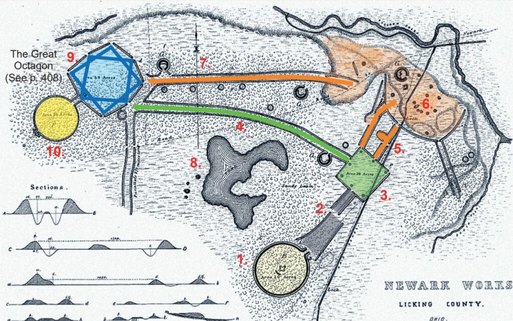
The Newark Earthworks above built between 100 A.D. to 500 A.D.,* originally encompassed
more than four square miles. Taken as a whole, the earthworks appear to symbolize elements of the Plan of Salvation and Redemption:
1. Pre-Mortal Life as spirits being born with a…
2. Veil of Forgetfulness to begin mortal…
3. Earth life: “the four corners of the earth”
4. Direct path after death to a higher kingdom
5. Spirit Prison (holding area for the wicked)
6. Paradise (Gospel preached to the dead)
7. Vicarious Path with multiple check points
8. Lake of Filthy Water (worldly temptations)
9. Terrestrial Kingdom (cf. 1 Cor. 15:40) The Seal of
Melchizedek consists of two interlocked (or overlapping)
squares, making what appears to be an
eight-pointed star within the octagon.
10. Celestial Kingdom (narrow path entered only
through the realm of the Melchizedek Priesthood)
History of Hamilton County Indiana Continued, “The earthwork at Strawtown is best described as a ‘Henge’ that is defined as a circular earthwork with a outer wall and interior ditch with a gateway that is aligned to a solar event. The gateway is slightly visible on the southeast side that may have aligned to the winter solstice sunrise. Later, accurate measurements were made of the mound. It was found that the principle enclosure is situated about seven hundred feet west of the river on an elevated point of land extending in a northwesterly direction into the bend of White River. This elevated point of land overlooks a strip of low bottom land varying in width from four hundred feet on the east to three thousand feet on the west, with a similar view north and south. The principal mound is a circle with a diameter measuring two hundred eighty feet from side to side.

From this point the outer slope to the middle of the ditch surrounding it is about twenty feet, the ditch originally having been about thirty feet wide and nine feet deep, the earth and gravel therefrom forming the mound in the center. Inside the enclosure the middle area was originally, no doubt, of equal elevation with the surface outside.

There is very little doubt that the purpose of this mound was for defense, the ditch outside being designed to resist assault. From time to time various specimens of bones, pottery, flint, arrowheads, etc., have been found, though no thorough and systematic search has ever been made of the contents of the mound. In the spring of 1914 some men were plowing over that part of the field included in the ancient mound and they unearthed about two bushel baskets full of human bones. At various times in the past such discoveries had been made but this was the first disclosure of this sort for several years. The ditch surrounding the fort is becoming less and less distinct as the years go by, and though it still be plainly seen, in the course of a few more years the hand of Father Time probably will completely obliterate it.
Additional embankments can still be seen to the south of the earthwork that were not reported in the previous histories, nor found by university archaeologists.” History of Hamilton County Indiana, 1915 The Fort and Mound
Leave a Reply