
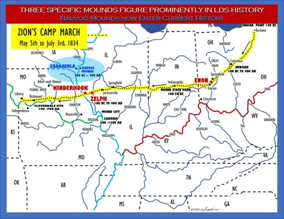
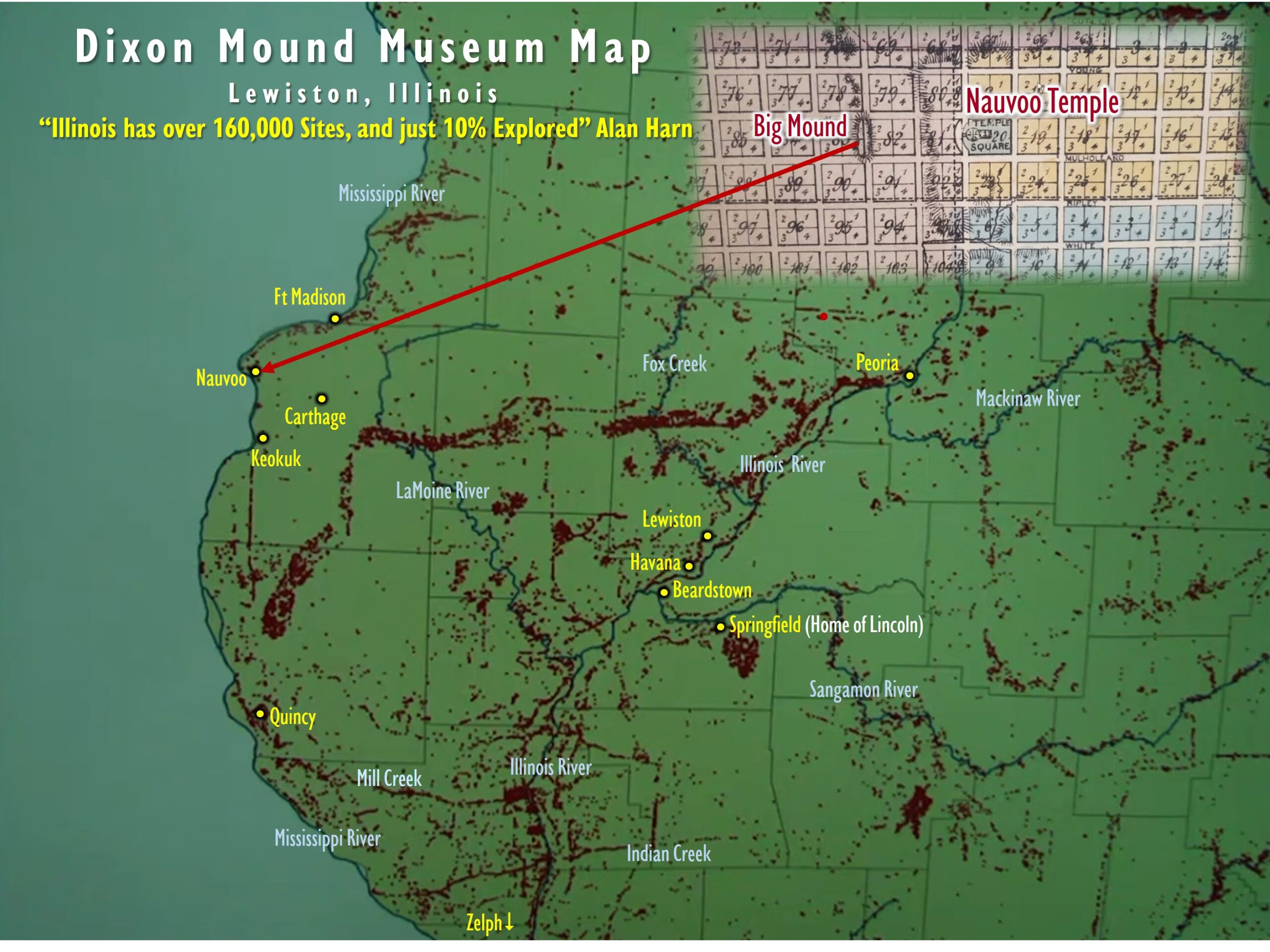
Nauvoo Sacred Mounds
“In the early 1970’s, when they were re-building Joseph’s Red Brick Store, while digging a trench for spot light wiring, they hit some artifacts, which resulted in calling in the archaeologists who then unearthed more artifacts and bones, all carbon dated to the Hopewell civilization of at least 2000 years ago..” Lachlan McKay quoted by Wilson Curlee
“Joseph Smith, his wife Emma, his brother Hyrum and his parents are buried in a Hopewell burial site.” Jonathan Neville
“We learned later that there were ten main mounds that were recognized by the State of Illinois as ancient burials.” Jenny Curlee More Here:https://bookofmormonevidence.org/nauvoo/
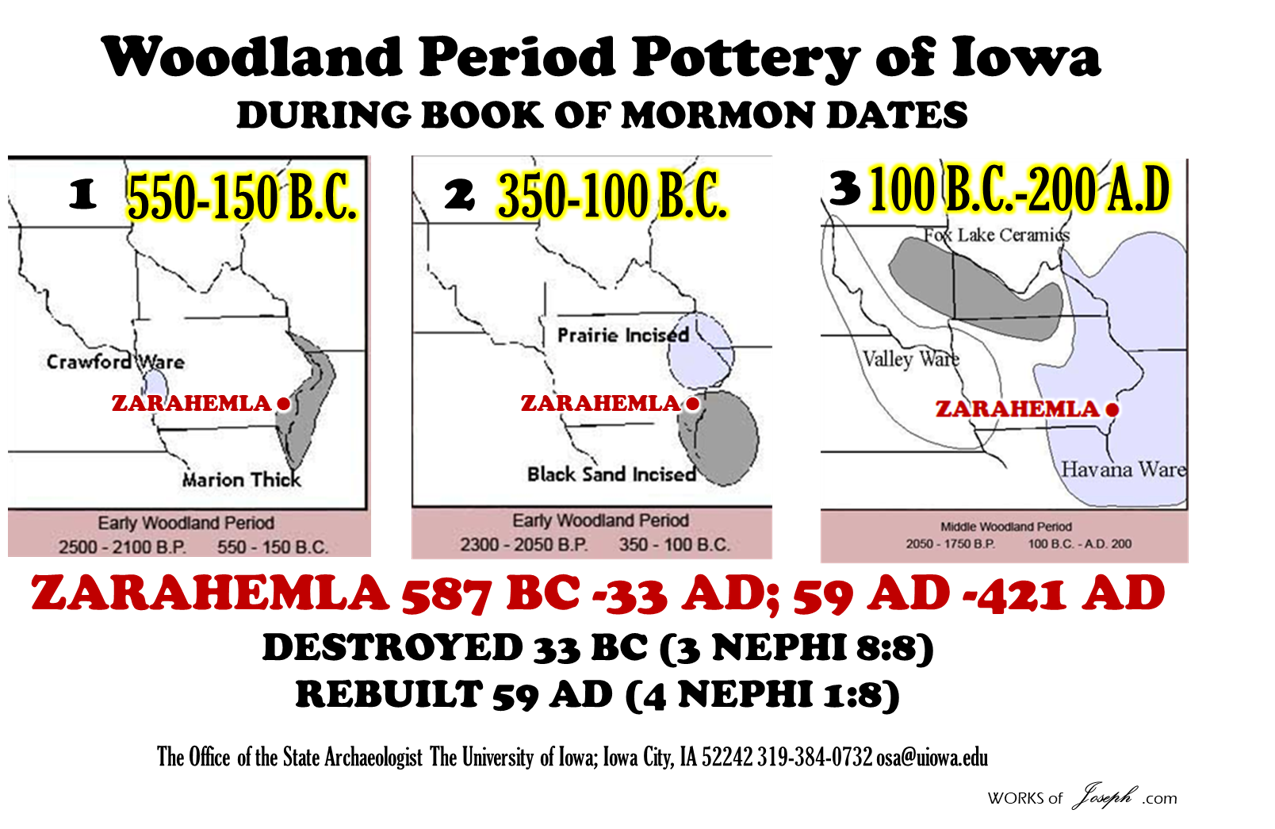
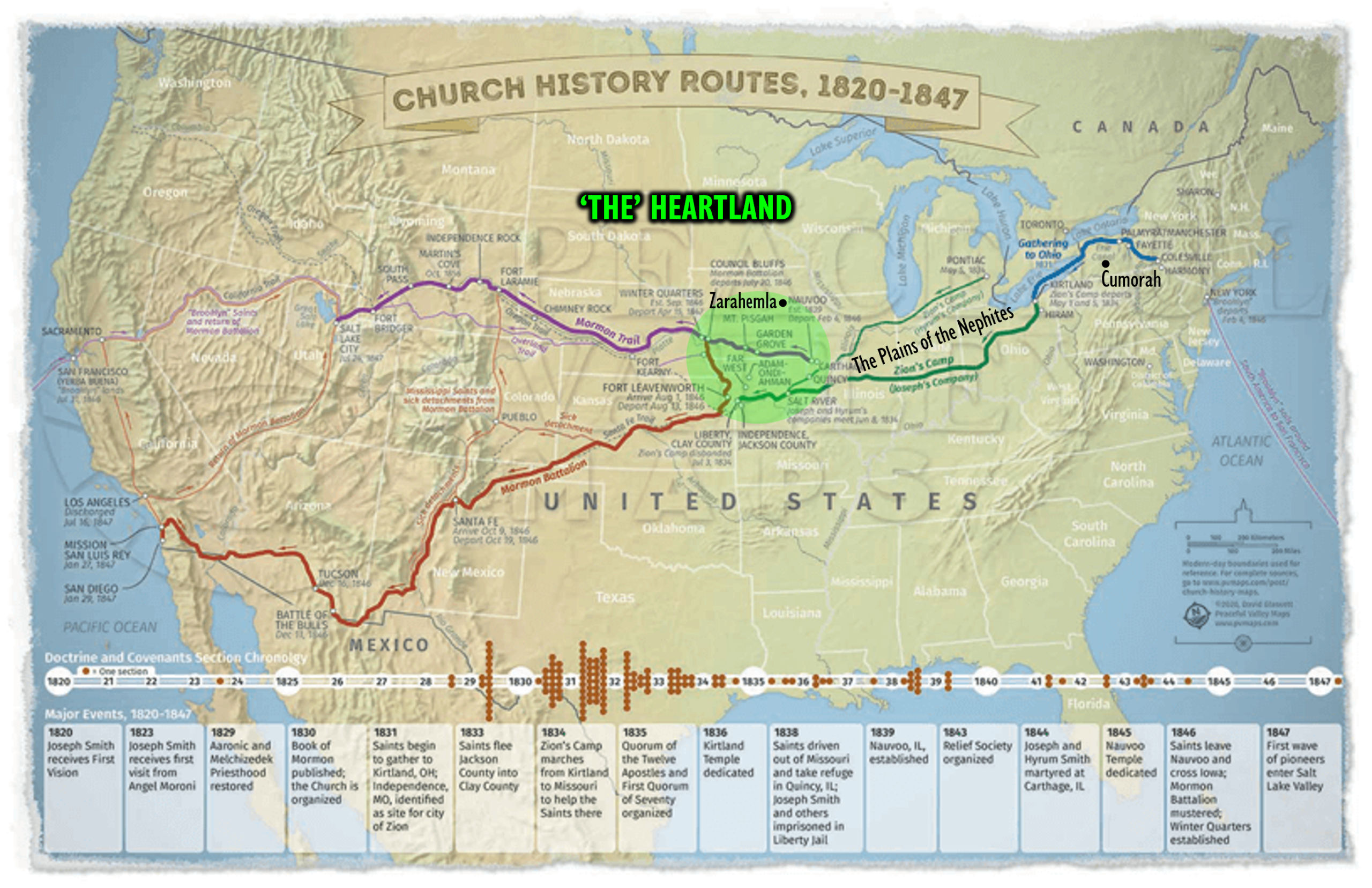
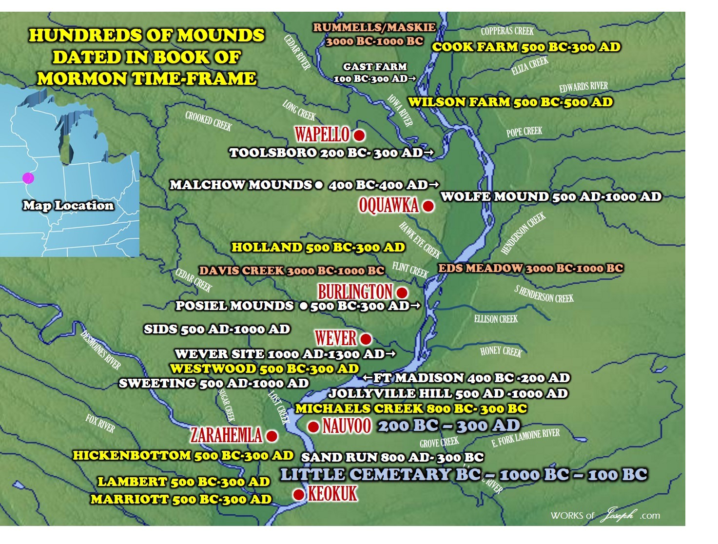
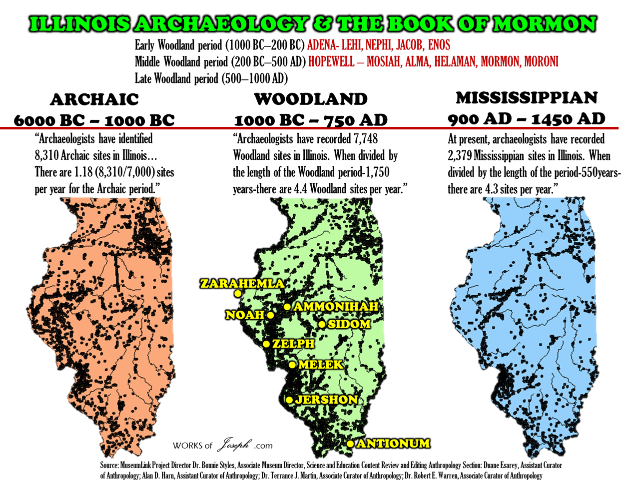
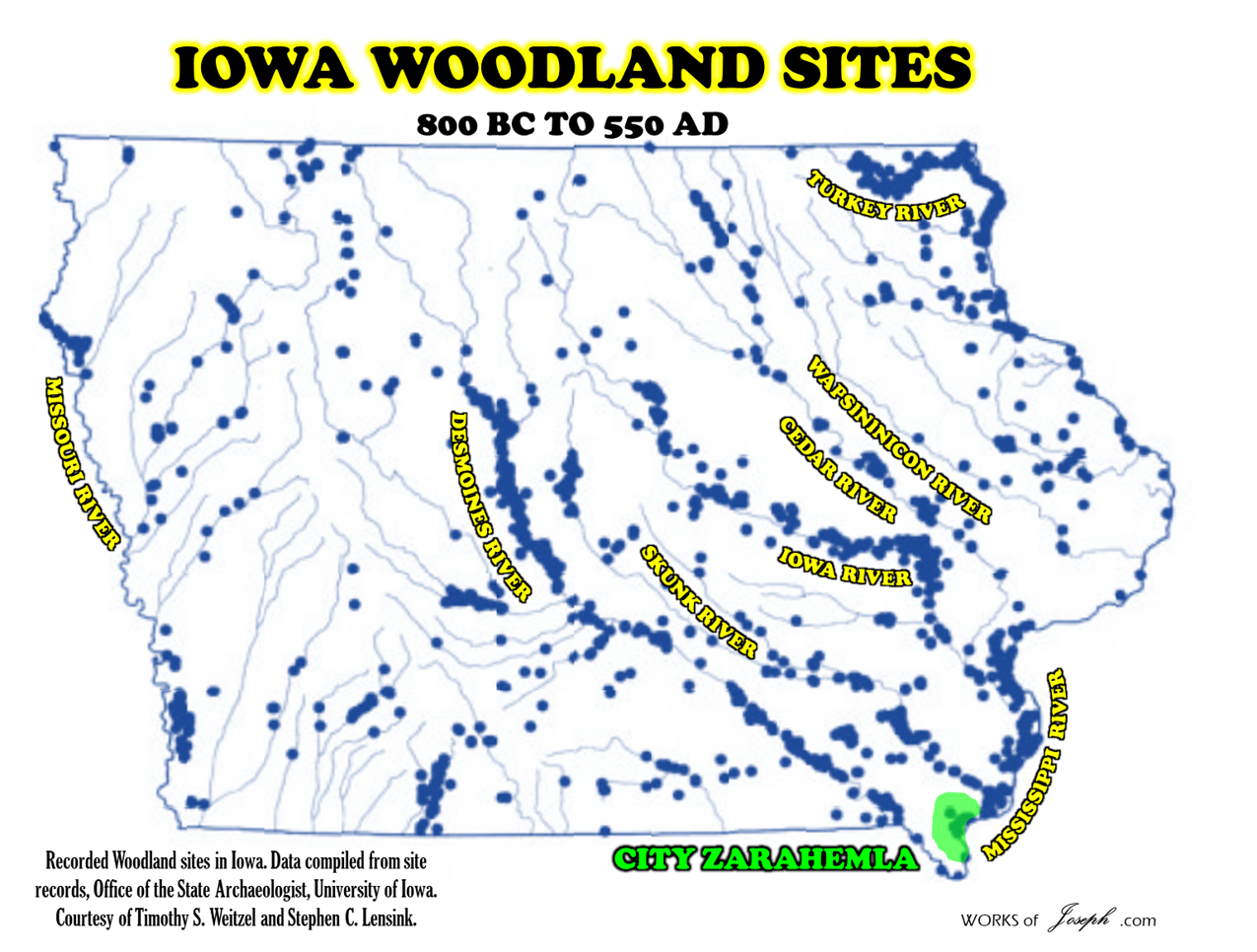
The People of Zarahemla were located near Nauvoo, Ill. in about 586 BC. The City of Zarahemla is first named in the Book of Mormon in about 130 BC.
The City of Zarahemla
Book: Most prominently from Mosiah 1–2 and Alma 2 onward | Time frame: ~circa 130 B.C. and destroyed in about 322 to 385 AD
While the land is named in Omni, the City of Zarahemla served as the capital of the Nephite nation from about 200 B.C. to A.D. 30, when the commonwealth was disrupted and the people divided into tribes. It was situated on the west bank of the Sidon river, and was originally built by the descendants of the people of Mulek, who left Jerusalem in 589 B.C. The city is explicitly named and described as a distinct urban center beginning in Mosiah 1–2 (~124 B.C., when King Benjamin addresses the people from a tower at the temple there) and then throughout the book of Alma (e.g., Alma 2, 4, 5). In 6 B.C., Samuel the Lamanite appeared upon the walls of Zarahemla and prophesied of wondrous events, foretelling its destruction by fire from heaven due to the wickedness of its inhabitants (Helaman 13:12–14). In accordance with this prophecy, Zarahemla was destroyed during the great upheavals that attended the crucifixion of Jesus Christ, but was afterward rebuilt. Wikisource
Kansas City Hopewell 300 BC to 500 AD
“The Kansas City Hopewell were the farthest west regional variation of the Hopewell tradition of the Middle Woodland period (100 BCE – 700 CE). Sites were located in Kansas and Missouri around the mouth of the Kansas River where it enters the Missouri River. There are 30 recorded Kansas City Hopewell sites.
The sites are made up of distinctive pottery styles and impressive burial mounds containing stone vault tombs. It is however uncertain whether this culture developed locally when people adopted Hopewell traits, or if westward migrating Hopewell people brought it all with them.
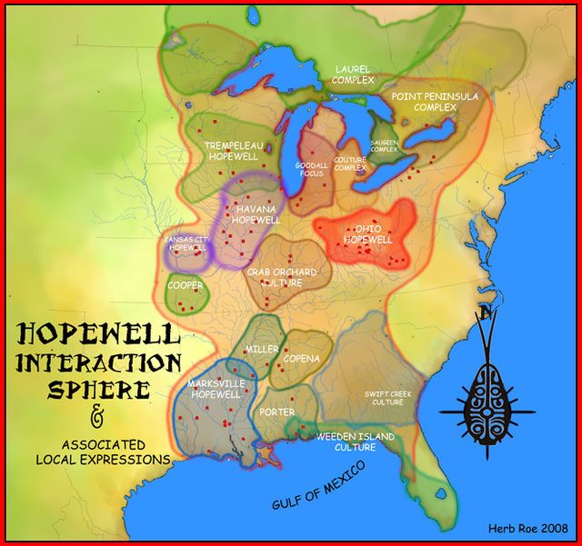
Hopewell Interaction Sphere
The Hopewell Exchange system began in the Ohio and Illinois river valleys about 300 BCE. The culture is referred to more as a system of interaction among a variety of societies than as a single society or culture. Hopewell trading networks were quite extensive, as has been found by the evidence of goods such as obsidian from the Yellowstone area, copper from Lake Superior, and shells from the Gulf Coast in locations distant from their origins.
Kansas City Hopewell
The Kansas City Hopewell period is divided by archaeologists into three phases based on radiocarbon dates and changes in projectile point styles and ceramic decoration.” Wikipedia
| Phase | Dates |
|---|---|
| Trowbridge | 1 – 250 CE |
| Kansas City | 250 – 500 CE |
| Edwardsville | 500 – 750 CE |
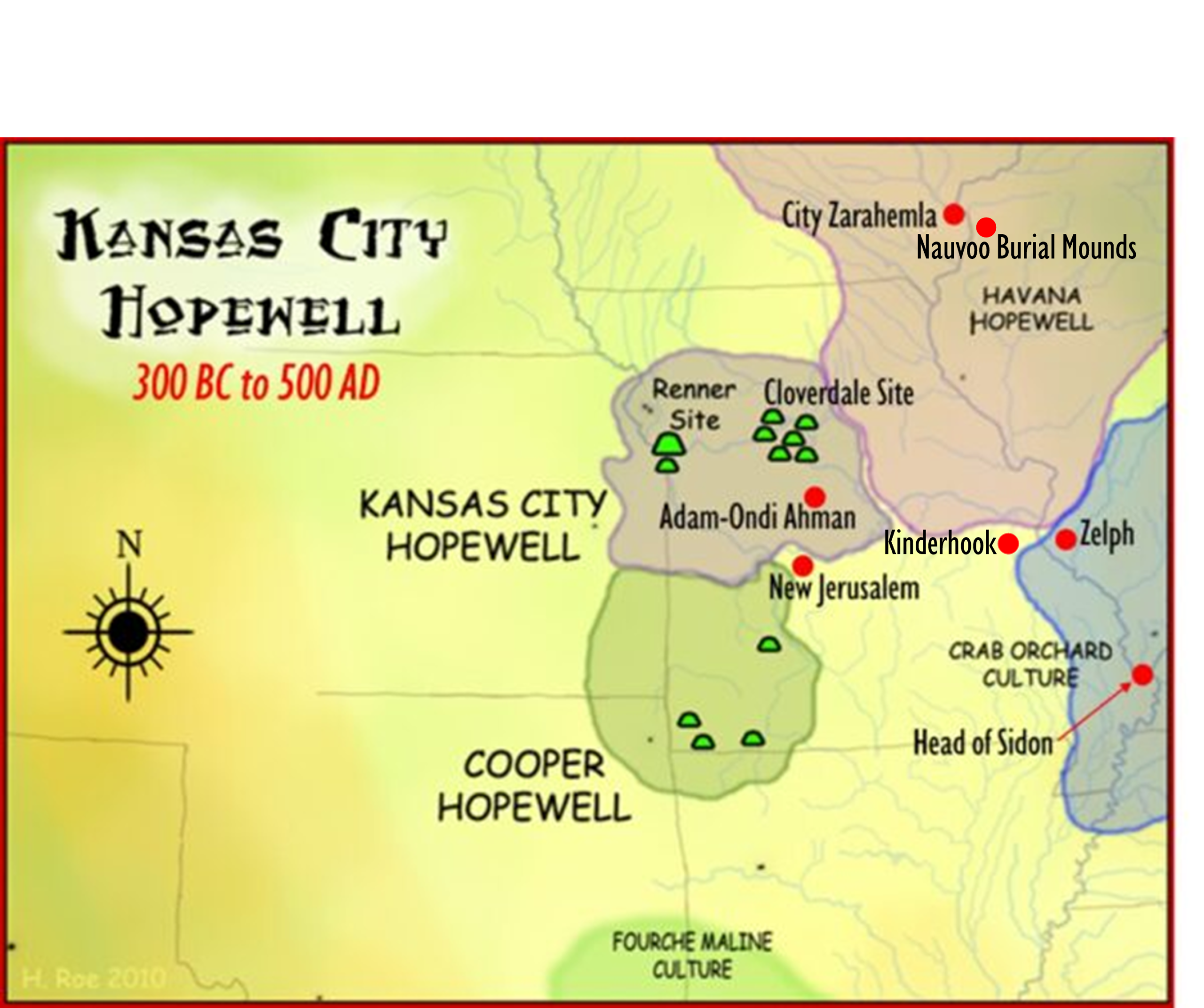 The Kansas City Hopewell represents the westernmost regional variant of the Hopewell archaeological complex that dates to the Middle Woodland or Early Ceramic (100 B.C. – 700 A.D.) period (Table 1). There are 30 recorded Kansas City Hopewell sites, centered around the junction of the Kansas and Missouri Rivers in northeastern Kansas and northwestern Missouri [map1]*. Other Hopewell variants extend throughout much of the eastern woodlands of North America and included variants such as the Ohio Hopewell, the Marksville Hopewell, and New York Hopewell [map2]*.
| Early Woodland | 500 B.C. – A.D. 1 | |
| Middle Woodland | A.D. 1 – A.D. 500 | Kansas City Hopewell |
| Late Woodland | A.D. 500 – A.D. 1000 |
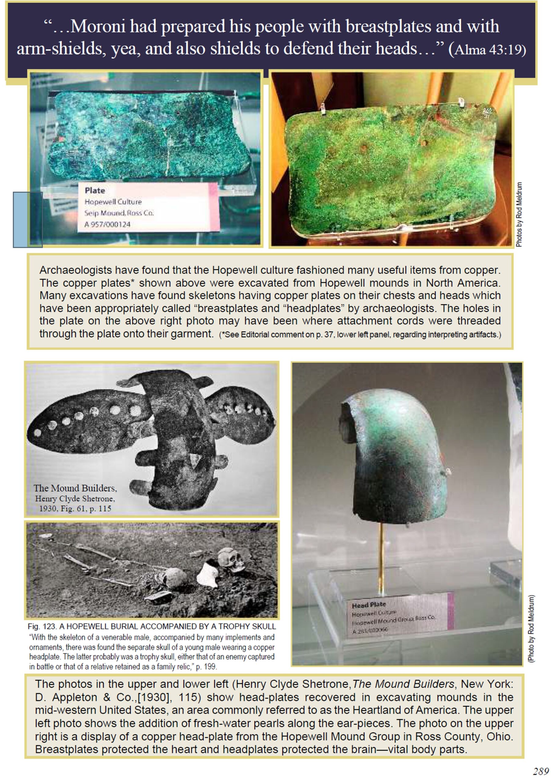 Annotated Book of Mormon by David Hocking and Rod Meldrum page 289
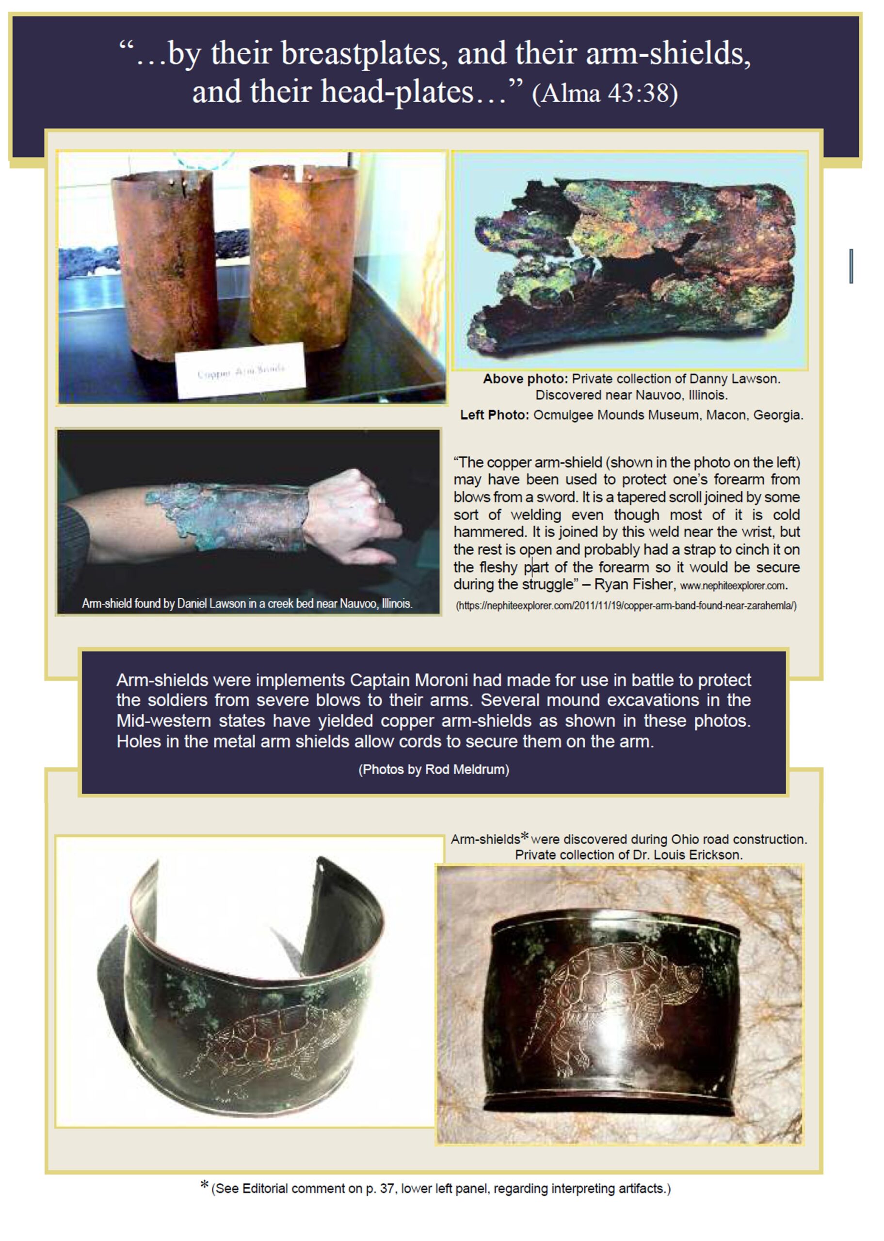
Headplates, Arm-shields, and Breastplates among the Nephites
“And the work of death commenced on both sides, but it was more dreadful on the part of the Lamanites, for their nakedness was exposed to the heavy blows of the Nephites with their swords and their cimeters, which brought death almost at every stroke. While on the other hand, there was now and then a man fell among the Nephites by their swords [wounds*] and the loss of blood, they being shielded from the more vital parts of the body, or the more vital parts of the body being shielded from the strokes of the Lamanites, by their breastplates, and their arm-shields, and their headplates; and thus the Nephites did carry on the work of death among the Lamanites.” Alma 43:37-38
Cloverdale, Missouri Archaeological Site
The Cloverdale archaeological site (23BN2) is an archaeological site located near present-day St. Joseph, Missouri. It is situated at the mouth of a small valley that opens into the Missouri River.
Excavations have shown that the site was first occupied by Kansas City Hopewell (c. 100 to 500 CE) peoples. Hundreds of years later, it was occupied by Steed-Kisker peoples (c. 1200) in the area of present-day Kansas City, Missouri. They were originally thought to be of the Plains Village period or tradition that was widespread in the central plains.
But archeologists have found evidence of significant differences, including habitation in farmsteads rather than villages, and pottery and building design more similar to the Middle Mississippian found at Cahokia, east of the Mississippi River, than to what was typical of the Plains Village. For instance, a house excavated at Cloverdale was similar to some at Cahokia: small, rectangular and partially subterranean, with wall posts set in individual holes.
In addition, Middle Mississippian shouldered jars with incised decoration were found at Cloverdale; these were typical of Cahokia style, as were water bottles, bean pots, and certain effigy forms found here. Other Mississippian items were many projectile points found at this site.
They have concluded that from about 1000-1250 CE, the people were migrants from Cahokia and similar Mississippian centers. The people increasingly adapted to local culture, resources and materials, developing a tradition that combined Mississippian and Plains elements.
Cahokia had developed a major urban center to the east of the Mississippi River, featuring numerous platform mounds and other forms of major earthworks, and gathering a large, dense population. It was the largest and central urban center of the Mississippian culture, which extended throughout the Ohio and Mississippi valleys and into the Southeast.” https://en.wikipedia.org/wiki/Cloverdale_archaeological_site

The Renner Village Hopewell Archeological Site
The Renner Village Archeological Site (23PL1) is a prehistoric archaeological site located in the municipality of Riverside, Platte County, Missouri. It was a village site inhabited from approximately 1 CE to 500 CE by peoples of the Kansas City Hopewell culture and through the Woodland period to 1200 CE by peoples of the Middle Mississippian culture. It was added to the National Historic Register on April 16, 1969.
Excavations
Archaeologists have found artifacts relating to the Hopewell and Middle Mississippian at the site, which is one of several Kansas City Hopewell sites located near the junction of Line Creek and the Missouri River.
The site was first excavated by Waldo Wedel of the US National Museum in 1937. He discovered decorated pottery styles typical of Hopewell pottery. It was excavated for a second time in 1954 by the Kansas City Archaeological Society and a third time by Gary Brenner from 1980 to 1993.
During the summer of 2009 the site was the subject of local controversy over the building of a new playground at the location. The city council of Riverside listened to testimony from archaeologists and local residents and decided to pay for rescue excavations at the site. Cultural Resource Services Group at SCI Engineering was contracted to do the excavation work in the summer of 2009 and the area was opened to the public in the spring of 2010 as Renner-Brenner Park, named for two families who had owned the site.” https://en.wikipedia.org/wiki/Renner_Village_Archeological_Site

15 Things Archeologists Discovered In Missouri That Will Amaze You
Missouri is home to numerous significant archaeological finds, including artifacts from various historical periods.
1. Jaguar Gorget from Fairfield Mound in Benton County

The Jaguar Gorget is the most recognizable Missouri artifact. It was most likely made during the Middle Woodland period (250 B.C.- 450 A.D.).
2. Bone tool from Boone County

The workmanship on this is fascinating.
3. Head pot from Pemiscot County.

4. Cahokia point found in Jefferson County

Cahokia points were made between A.D. 900 and 1300.
5. Walls Engraved Bottle

Found in Southeast Missouri, this bottle is from the Mississippian Period (A.D. 800 to 1600) and is 21.5 cm tall.
6. Graham Cave point from Graham Cave

The cave is now a Missouri State Park just off I-70 near Danville. The cave has been excavated between 1949 and 1961 by The University of Missouri and the Missouri Archaeological Society. The site protects Pre-Columbian artifacts from the ancient Dalton and Archaic period dating back to as early as 10,000 years ago.
7. Dalton Point

A beautiful Dalton point that dates back to 8950 – 7900 B.C. One of the oldest known point types in North America, Dalton points normally demonstrate exceptional workmanship.
8. Jesuit Rings

These three brass rings found at archaeological sites in Missouri are examples of Jesuit rings. These rings were used by missionaries in the 17th and 18th centuries, possibly as gifts to recent native converts.
On the top ring, the IHS design stands for Iesus Hominum Salvator, meaning “Jesus Savior of Mankind.”
The middle rings’ Double-M design has an inverted M superimposed over an upright M and stands for Mater Misericordia, or “Mother of Mercy.”
The bottom ring depicts a Crucifixion scene.
9. A discoidal from Butler County.

The discoidal is made from granite and is 5.9 cm in diameter. Our friends at Arrowheads.com define a discoidal as “a round Mississippian game stone that was used in the ancient Native American game known as chungke or chunkey.”
10. Council ring, Graham Cave

The above image shows the edge of an excavation with layers that have been dated more than 8800 years back. It partially exposes a circle of stones around a larger stone, considered to possibly be a council ring.
11. Turtle Effigy Vessel found at Murphy Mound in Pemiscot County

This turtle effigy is an example of a Cat-monster vessel, which describes a type of pottery where the bowl is the body of an animal or “monster” with carved designs forming the head and tail. These are frequently found in the central Mississippi River valley, and especially in Pemiscot County. The style dates from the Late Mississippian period, after A.D. 1350.
12. Lilbourn Mace found in New Madrid County

The Lilbourn Mace is one of the most unique artifacts found in Missouri. It is Mill Creek chert and measures 40 cm long, 13 cm wide, and 2.3 cm thick. It dates back to the Middle Mississippian period (A.D. 1200 – 1400).
13. A mastodon skeleton on display in the museum at the Mastodon State Historical Site in Imperial

The Mastodon State Historic Site is a 431-acre archaeological and paleontological site with recreational features that preserves the Kimmswick Bone Bed. In the early 19th century, bones of mastodons and other now-extinct animals were first found at this location. As a result, the area became well known as one of the most extensive Pleistocene ice age deposits in the country.

When scientists excavated a stone spear point made by hunters of the Clovis culture (14,000-10,000 years ago) in 1979, history was made. The point was found in direct association with mastodon bones, creating the first solid evidence of the coexistence of mastodons and people. The Kimmswick Bone Bed was added to the National Register of Historic Places in 1980.
14. Paddlewheel of the Arabia located at the Arabia Steamboat Museum in Kansas City

The steamboat Arabia was a side wheeler steamboat built in 1853 in Brownsville, Pennsylvania. On September 5, 1856, it hit a snag in the Missouri River and sank near Parkville, Missouri. The steamboat and its contents were found in the late 1980s by a team of researchers. We recently posted about this Archaeological site in Missouri if you’re interested in more information.
15. Cahokia Copper, left figure from Malden

Pictured are three examples of Mississippian culture avian-themed repoussé copper plates. The figure on the right is from Spiro Mounds in Oklahoma, and the middle plate is from the Etowah Mounds in Georgia. The figure on the left is Wulfing plate A, one of Wulfing cache from Malden, Missouri. Many examples of this type of artwork have been found in many states throughout the Midwest and Southeast.
Which was your favorite? We especially love the head pot and the amazing Cahokia copper! All of these artifacts are intriguing for infinite reasons, and we’re curious: which one interests you the most? Let us know.
A special thanks to The University of Missouri Museum of Anthropology as well for their help and information about these amazing items.” https://www.onlyinyourstate.com/state-pride/missouri/archeologists-discoveries-mo
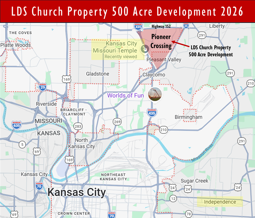
LDS Church–Linked Property Development in Kansas City Area
AI Copilot says the following:
“A major LDS Church–connected real estate project in the Kansas City area is Pioneer Crossing, a proposed $2.3 billion mixed-use development on about 472 acres in Clay County, near Interstate 435 and Highway 152 in the Northland region www.utahmoneywatch.com. The project is being advanced by Land Reserve, Inc., a Utah-based real estate entity owned by the Church’s Property Reserve fund.
Project Scope
If approved and built, Pioneer Crossing would include:
- Over 1 million sq. ft. of retail
- Hundreds of thousands of sq. ft. of office space
- ~1,500 residential units
- A 150‑room hotel
- Restaurants, entertainment, sports facilities, and conference space
- ~4,000 parking spaces www.utahmoneywatch.com
The plan draws on concepts from other large developments like Johnson County’s Corporate Woods and Wyandotte County’s Legends project KMBC Channel 9.
Related Land Sales
The LDS Church has also listed 533 acres in the same Northland area (near I‑435 and I‑152) for sale, marketed as Project 587 KMBC Channel 9. This land is part of a larger 1,860‑acre tract the Church sold in Lee’s Summit, MO, which is already in city master plans for commercial, industrial, and residential uses Metro Voice News. The Clay County Economic Development Council has endorsed a plan for the 587 project, envisioning amenities like a VA hospital, youth ball fields, and parks KMBC Channel 9.
Status
Pioneer Crossing has moved through part of Kansas City’s public‑finance approval process, but full council action is still pending www.utahmoneywatch.com. The 587 land listing has generated significant interest from developers, though local officials are pushing for adherence to earlier master plans before endorsing final designs KMBC Channel 9.
Significance
This project is notable for its scale and LDS Church ownership, positioning it as part of a broader pattern of Utah‑controlled institutional capital shaping large‑scale developments beyond Salt Lake City www.utahmoneywatch.com. If realized, it could become one of the largest mixed‑use developments in the Kansas City metro area.” CoPilot AI
There is so much information about ‘THE’ Heartland of the Promised Land in Iowa, Missouri, and Illinois. I challenge you to do your own research and evaluate, then pray abut it to have the opportunity to receive personal revelation on truth.