
“An overview of our thesis can be summarized in a few sentences. Without Lake Superior’s shores, millions of pounds of pure metallic copper would not have been available for the civilizations of the Old World. North American copper was a critical part of the Old World’s Bronze Age, and this conclusion is heavily influenced by your research.
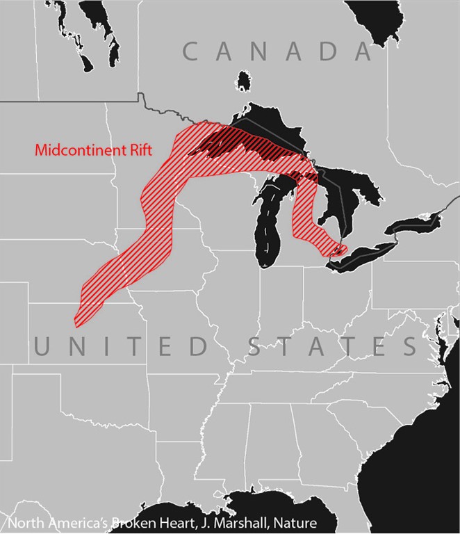
“Researchers, historians, and enthusiasts met for four hours to discuss groundbreaking evidence about ancient Michigan copper trade during the Bronze Age. In the discussion, Ricardo Calvário presented his research demonstrating that approximately 90% of Bronze Age copper was produced in Michigan’s Upper Peninsula, based on isotopic analysis and Old World copper production capacity. Participants discussed the geological significance of the Midcontinent Rift, ongoing artifact testing programs, methodologies for identifying Michigan copper, and challenges in gaining academic acceptance. A Native American eagle dance and a discussion on historical artifacts found throughout North America were also featured at the meeting.” John Lefgren PhD Heartland Research Group
After the event the local newspaper said, “Heartland Research Inc., behind the Phoenicia project out of Montrose, held a live-streaming event connecting experts from North America and Europe to Keokuk, talking about the Mid Continental Rift and its association with copper as a Bronze Age resource. Project leader John Lefgren, Ph.D., was present, ready to share details with inquisitive visitors about their research findings, and give updates on the Phoenicia replica – the group says Phoenicia crossed the Atlantic long before European explorers.” Daily Gate city Newspaper, Keokuk Iowa. Jan 21, 2026.
Regards,
John Lefgren, PhD
Heartland Research Inc
Montrose, Iowa
Richard Calvrio
And his weekly live with Rick Osmon, every Friday at 7pm EST:
https://www.youtube.com/live/JNhZkBQAtFg?si=g_PlNzEiU9HkeY9A
COPPER HISTORY
BRONZE AGE IN AMERICA w. MINOANS & MYCENAEANS , by Colette Smith
(This is a MAJOR EDUCATION in not only Mediterranean history, but world history. NEVER did any level of public school or university EDU teach us accurate history of the origin & timing of the BRONZE AGE, its development and critical role in both oceanic trade & pre-Columbian American history, plus the historically-pertinent, global effects of its cataclysmic, volcanic end! WOW !! Human history is correlated with the ice ages like nowhere else
The author did a masterful job of presenting true history, its causes and effects. Thank you Colette, and thank you Ancient American Magazine.)
America’s history was influenced heavily by seafaring trade efforts all over ancient Europe. England started the “Bronze Age” (BA) about 4000 BCE by smelting local copper with tin or zinc into alloys called bronze and brass. A search was soon on for additional copper. Somehow, someone discovered the world’s richest and largest deposits of nearly pure copper on the northern shores Lake Superior in the new world’s “Great lakes” area. It is no pun to say that new world truly had “Superior Copper.” The European side of the story makes it appear that they did the mining and shipping, with their own imported settlements of thousands of miners.
(Note: An untold American story is that a population of immigrants (Jaredites) from Babylon had settled in the Great Lakes about the time of the Babylonian confusion of tongues and separation of continents, and were mining and trading this copper in the “new world,” virtually from their own back yard. That connection has not yet been made, historically, only that their burial artifacts contain that unique blend of copper ore. To what degree, if any, the Jaredites participated in or even controlled the copper mining and international shipping is not known.)
Meanwhile, many nations around the world were actively sailing the oceans seeking commercial trade. The ancients were master navigators, and understood both the ocean currents and the stars. English and Scandinavians sailed to Iceland and Greenland. Chinese, Indians, and Indonesians were sailing to America’s western coasts, while Minoans of Crete dominated the Mediterranean Sea zone. Arabians explored Africa’s east coast and trade routes to India and China. Wherever sailors landed, they impacted any local cultures with their own. For example, the ancient Far East Hindu influence in meso-American culture is obvious.
Militant competition ruled the seas; they had the ships and the seamanship to enforce it. Soon Minoan shipping became a primary commercial force in the rich, “new world” copper trade, servicing all ports in Europe and the Mediterranean. The BA hit full stride in its 2000-year roll.
A Minoan competitor group from the Island of Knossos, near Cyprus – descendants from Japheth – muscled the Minoans into a subservient role in the giant Copper Trade, about 1500 BCE.
It is of prime importance to know that the earth’s climate was much warmer during the BA. There was no arctic ice. The Arctic Circle was open east to west across both segments of the recently-separated Pangea. Northern Scandinavia and Russia were not frozen. The Great Lakes were deeper and wider, rivers and water tables were all higher.
From this AA issue and others, we learn that primary shipping routes TO the Superior copper mines were via Hudson Bay, canoeing rivers south into Lake Superior, then OUT with fleets of small boat loads of ore, via either Lake Huron to the St Laurence, or Lake Michigan to Chicago River and the Mississippi. Small river boats of ore would then load onto ocean ships at Hudson Bay, St. Lawrence Seaway or New Orleans. New Orleans even had smelting sites to reduce the ore volume to pure, flat ingots. St Lawrence routes served N. Europe best, whereas New Orleans ships could service the Caribbean, or African routes to the Far East. By this vigorous trade over BA’s 2000-yr. life, Superior copper products have been identified all over the world.
But nature suddenly ended the BA about 1400 BCE. Minoan’s home base Island of Santorini exploded in the world’s most violent volcanic eruption ever known before or since. Minoa Island nearly disappeared, Crete, Cyprus and Knossus were wiped out in the first hour, along with catastrophic destruction throughout the Caribbean shorelines. A 75-ft Tsunami blasted all shores within 500 miles. Horrific air pollution shaded the earth’s sun for over a year, causing draughts, climate changes, diseases and starvation conditions for decades globally. Returning sailors sailed through Mediterranean debris to discover their home world had disappeared. Superior copper trade suddenly ended also, with workers walking away from their tools.
Surviving Phoenicians were quick to fill the gap in shipping trade to the Mediterranean, Atlantic and Far East. Their Phoenician “Golden Age “ lasted from 1400 – 580 BCE, followed by Carthaginians; Greeks 150 BC, and the Romans 65 BC. About 1100 AD began a cooling trend; by 1100 AD the Arctic circle began to freeze into an Ice Age.
None of this coordinated science data has been taught in America’s education system. True history from many places has been consciously suppressed or rewritten, and evidences hidden from view or publication by those in political and academic power, in order to promote their favorite myth of “Columbus First – Manifest Destiny,” In America, the Smithsonian Institute has earned its reputation as the “mother of harlots” in all science and history records.
The Mystery of the Newberry Tablet
Posted on January 15, 2020 by Mike Sonnenberg
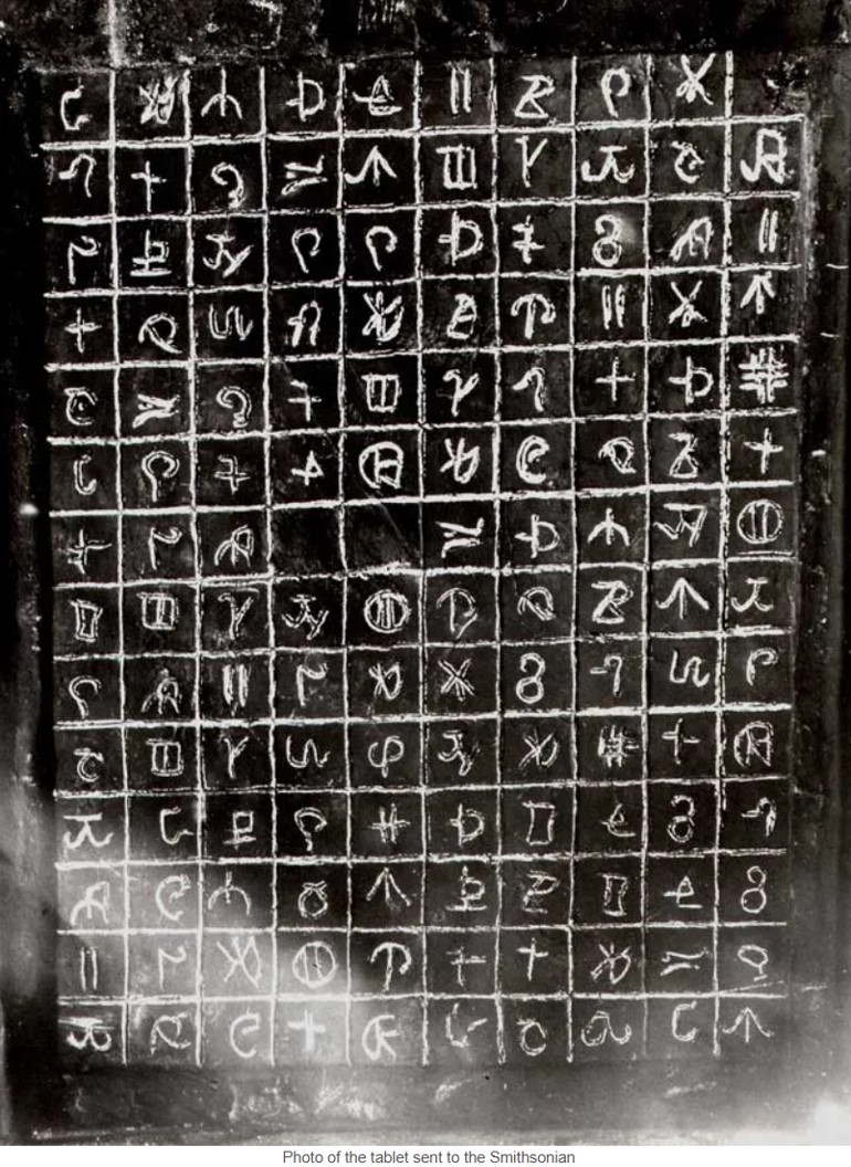
“I am not sure if it is a hoax or real, but it is an interesting story. Way back in 1896 two lumberjacks were hired to clear some land for a farmer near the Upper Peninsula town of Newberry. They happen to stumble upon two small clay figures and a tablet. The 19 x 26 inch tablet had 140 characters carved into a grid pattern. No one knew what to make of them so photos were sent to the Smithsonian and University Of Michigan. The experts at the time could not recognize the writing and they deemed the tablet as a hoax. Some modern experts believe the text is similar to Minoan writing. The Minoans lived from about 3000 BC to about 1100 BC on the Greek island of Crete.
The tablets remained somewhat of a local curiosity. Eventually, they ended up at a St. Ignace tourist destination called Fort Algonquin. ( you can see my post about the fort HERE) The fort was built by Vaughan Norton in the 1920s to look like an old fort from Michigan’s fur trading days. Somehow Vaught acquired the mysterious tablet to display for the tourist.
Eventually, the tablets and figures were purchased by Dr. Donald Benson. A doctor from Lansing who moved to St. Ignace. He loved to collect odd and historic artifacts and displayed them in the gift shop he owned. After his death, the artifacts went on display at the Fort De Buade Museum in downtown St. Ignace. The tablets, or more like what is left of them because they have been reduced to a couple of crumbling pieces with none of the writing remaining, is on display with the worn-down figures.
One theory is they have to be a hoax because if they are supposed to be hundreds or even thousands of years old, from the time of the Minoans, how did they survive for so long only to be eroded away in a short amount of time after they were discovered. Like I wrote at the beginning of the post, I am not sure it is real or a hoax, but it is an interesting story.” https://lostinmichigan.net/newberry-tablet/
Editor’s note: Just like the many other so-called hoaxes, I believe there is more truth than hoax. For example we know of the Decalogue Stone, the Bat Creek Stone, the Key Stone, Menorah Earthworks etc. When historians decide an item goes against their current bias, they reject these items as a hoax. As we research more and more, it’s just too convenient to dismiss all of these artifacts as a hoax. I love this discovery of the Newberry tablet, and as Moroni said, “we may know the truth of all things.” I’ll keep searching and praying, not for proof, but to add to my strong witness that the Gospel is true and the Book of Mormon is the word of God, and I believe Elder Perry who said, “The United States is the promised land foretold in the Book of Mormon—a place where divine guidance directed inspired men to create the conditions necessary for the Restoration of the gospel of Jesus Christ.” Elder L. Tom Perry Ensign Dec. 2012.
See video below titled, A Bronze Age Disappearance:
Who Took 1.5 Billion Pounds Of Copper From The Great Lakes?
THE MINERS OF MICHIGAN COPPER 2450 B.C. -1200 B.C. ETHER 10:23
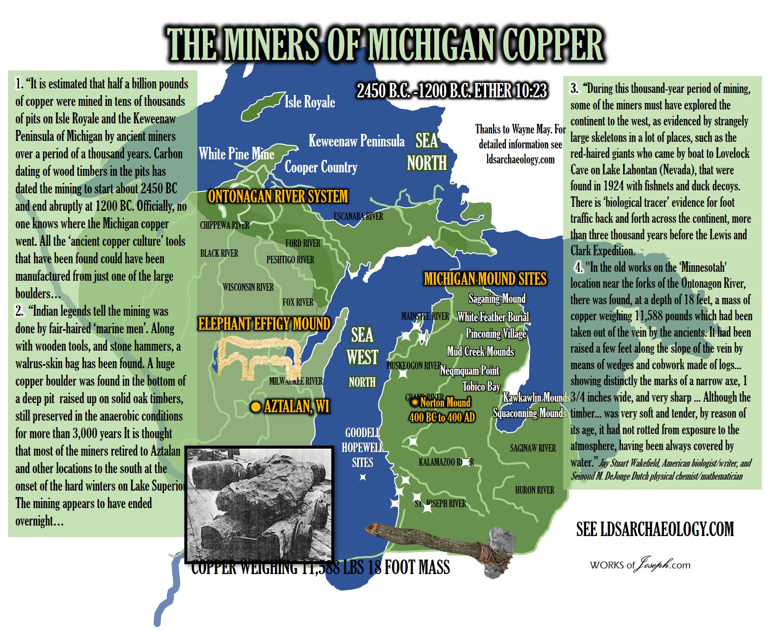 “It is estimated that half a billion pounds of copper were mined in tens of thousands of pits on Isle Royale and the Keweenaw Peninsula of Michigan by ancient miners over a period of a thousand years. Carbon dating of wood timbers in the pits has dated the mining to start about 2450 BC and end abruptly at 1200 BC. Officially, no one knows where the Michigan copper went. All the ‘ancient copper culture’ tools that have been found could have been manufactured from just one of the large boulders…
“Indian legends tell the mining was done by fair-haired ‘marine men’. Along with wooden tools, and stone hammers, a walrus-skin bag has been found. A huge copper boulder was found in the bottom of a deep pit raised up on solid oak timbers, still preserved in the anaerobic conditions for more than 3,000 years It is thought that most of the miners retired to Aztalan and other locations to the south at the onset of the hard winters on Lake Superior. The mining appears to have ended overnight…
“In the old works on the ‘Minnesotah’ location near the forks of the Ontonagon River, there was found, at a depth of 18 feet, a mass of copper weighing 11,588 pounds which had been taken out of the vein by the ancients. It had been raised a few feet along the slope of the vein by means of wedges and cobwork made of logs… showing distinctly the marks of a narrow axe, 1 3/4 inches wide, and very sharp … Although the timber… was very soft and tender, by reason of its age, it had not rotted from exposure to the atmosphere, having been always covered by water.”Jay Stuart Wakefield, American biologist/writer, and Seinoud M. DeJonge Dutch physical chemist/mathematician
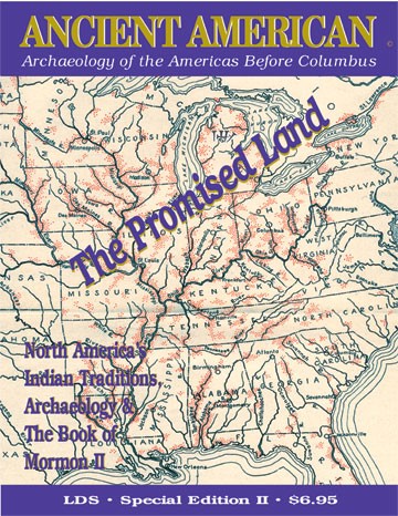
Ancient American LDS Special Edition Earth, Wood, and Copper, Trademarks of the Promised Land. The Ancient America LDS Special Editions covers a wide variety of topics from Native American Traditions, Archeological evidence of the Book of Mormon in North America, and writings from Joseph Smith and the Book of Mormon leaving no doubt that America is the The Promise Land of the scriptures. Magazine format, illustrated, 39pp. Inquire about purchase from Rian Nelson [email protected]
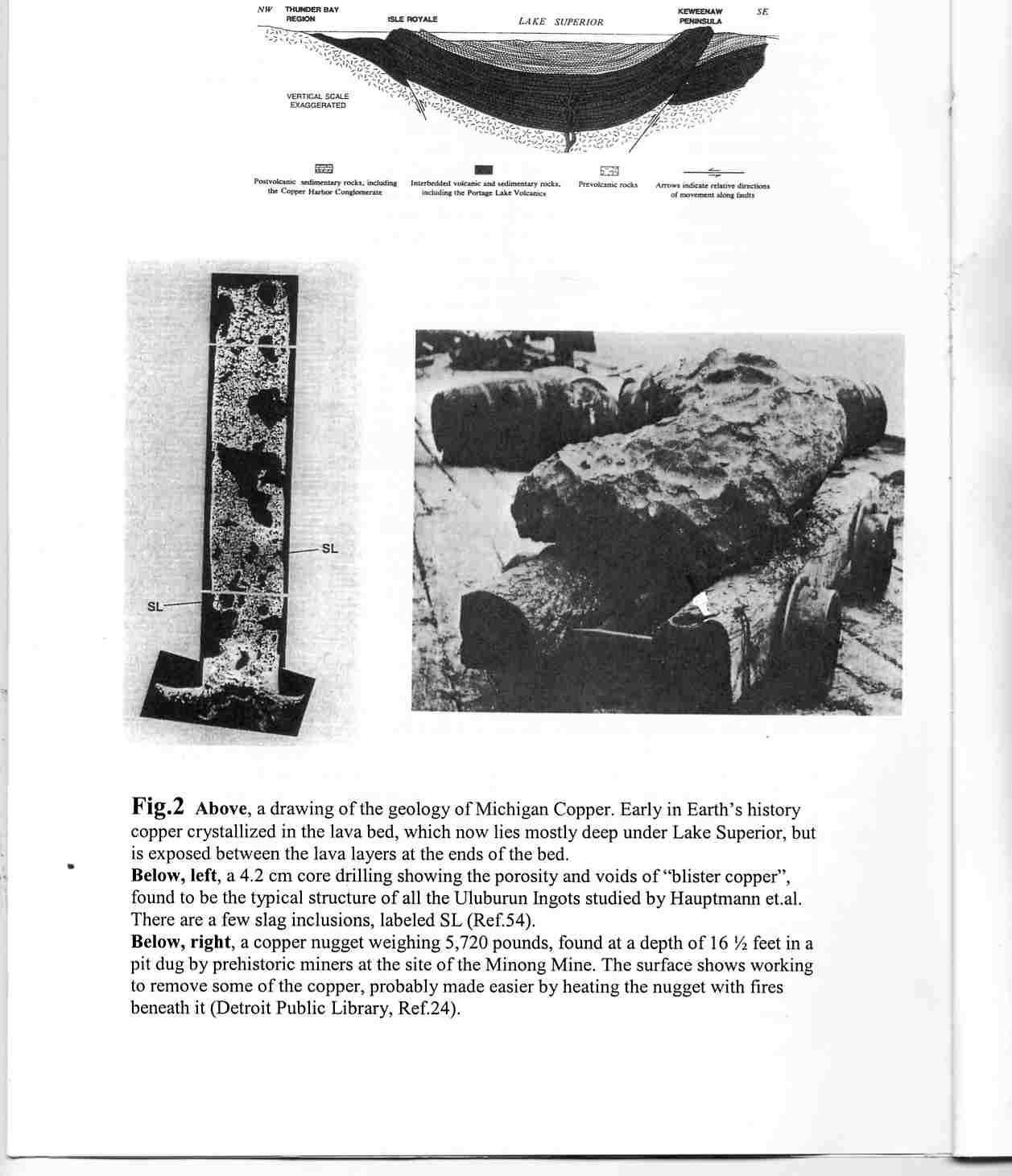
Picture right. Annotated Book of Mormon by David Hocking and Rod Meldrum page 152
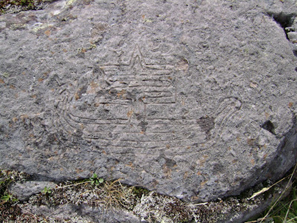
PETROGLYPH OF A SAILING BOAT (Copper Harbor, Upper Michigan, c.1640 BC)
The Institute for Megalithic Research Tuesday, 8 December 2009
Email: [email protected] —– October 26, 2009 —– Dr. R.M. de Jonge ©, [email protected]
Introduction
“The AAPS is the Ancient Artifact Preservation Society. It held its First Conference on Ancient Copper in the town of Houghton, on the Upper Peninsula of Michigan, July 10-12, 2009 (Refs.1-3).
One of the activities during the conference was a visit to the petroglyphs near Copper Harbor, on the northern tip of Keweenaw Peninsula. The most beautiful glyph is a hugh sailing boat, shown in Fig.1. In antiquity, the natural harbor of this town was used for the transport of copper ingots to Lake Michigan, and further south along the Mississippi River, as well as all the way to the east, to the Saint Lawrence River.”
Editor’s note: It also makes sense that Michigan Copper was transported to Europe for the Bronze age which was from 3,000 to 1,000 BC.
The Institute for Megalithic Research continues, “It was also important for reaching Isle Royale, some 50 miles to the northeast, another area of extensive mining operations (Refs.4,5,20-22). —– The petroglyph site near Copper Harbor is west of town near the end of the local bay. The glyph of the sailing boat has a width of 36cm, and a height of 17.5cm, including the top of the mast 19 cm. The hull of the ship has a height of 7cm, including the lower part of the mast almost 11cm. The sail has a width of 14.5cm. The carved lines are not V-shaped, but more U-shaped, having an upper width of 3.5 mm, and a depth of 2 mm. The carving was made on the ground, on a flat, natural area of the bedrock, consisting of sandstone. It is an oblong area of stone, having a height varying from roughly 30 to 60cm (Ref.3). —– The sailing boat should be considered as seaworthy (Refs.6,7). Some dimensions of this large boat are interesting. The length of the hull equals five times the height of the sail. The length of the sail equals the height of the mast, and both are twice the height of the sail. The height of the mast equals six times the width (or height) of the lower part of it, below the sail.- Finally, it should be noted, that the carved line within the sail makes a long zigzag all the way to the top. For the time being, it appears to be a mysterious feature of this petroglyph.
When studying the glyph, it appears that the left edge of the sail has been accidently flaked off (although it might have been done on purpose). Probably, it already happened when the glyph was carved, and apparently, people decided to make the best of the situation. However, it is also possible that the flaking off happened in a (much) later time period. In that case a careful restauration may now be observed.- Note, that a recent flaking off occurred near the sail, at the right si-de above. It just damaged a tiny part of the upper right corner of the glyph.
Date of the Glyph
The hull of the boat consists of five rows of planks, and the sail appears to be made of seven strips of cloth. When studying these horizontal elements of the carving, it appears to us, that in first instance, a dynasty encoding is most likely to be intended (Refs.8-10). Including the lower part of the mast the hull consists of 5+1= 6 elements, encoding the first six dynasties of Egypt. These are known to us as the Old Kingdom. The 5 rows of planks correspond to the first five dynasties, when the ancient Egyptian civilization flourished. The lower part of the mast corresponds to the 6th Dynasty, when the culture of Egypt was declining. —– The sail has seven strips of cloth, encoding the next, seven dynasties. It appears, that the upper strip provides the approximate date of the glyph. It corresponds to the 6+7= 13th Dynasty (c. 1794-1641 BC). The date of the glyph appears to coincide with the end of this dynasty, c.1640 BC.- Note, that the top of the mast peaks in two layers, which correspond to the 12th and 13th Dynasties. It is correct, that the culture of the Middle Kingdom started to decline at the end of the 12th Dynasty, a process which continued in the 13th Dynasty. Note also, that the bottom of the mast was placed on the fourth layer of the hull. It is correct, that the culture of the Old Kingdom started to decline at the end of the 5th Dynasty, a process which continued in the 6th Dynasty.”
The Institute for Megalithic Research (IMR) promotes the understanding of monuments and petroglyphs of the Megalithic Culture, which flourished in Europe but also worldwide, from c.6000 to 1000 BC. The goal is the publication of well written articles about this subject. The IMR is based in the Netherlands; present director is Dr. R.M. de Jonge. https://megalithicresearch.blogspot.com/2009/12/petroglyph-of-sailing-boat-copper.html
I love your map showing the “Northernmost Range of Arundaria (Cane).” Anciently, much of the eastern United States was covered with dense forests and cane fields (bamboo) of different varieties and heights. It extended up near the Ohio River. I believe this barrier was the number one reason why the Nephites and Mulekites did NOT discover each other for about 300 to 400 years. Eventually fields of sugar cane grew. This plant provided a good habitat for animals like Jaredite elephants, mammoths and mastodons. Exploring people were constantly getting lost in the forest.
You state “It is of prime importance to know that the earth’s climate was much warmer during the BA. There was no arctic ice.” I agree partially. Evidence of Tropical plants have been found in Ohio along with parrots. I believe the ice age began soon after Noah’s flood. The glaciers likely lasted several hundred years and the Jaredites overlapped the glacial period.
Ether 2:1, 5-6 states,
1 And it came to pass that Jared and his brother, and their families, and also the friends of Jared and his brother and their families, went down into the valley which was *****northward,***** (and the name of the valley was Nimrod, being called after the mighty hunter) with their flocks which they had gathered together, male and female, of every kind.
5 And it came to pass that the Lord commanded them that they should go forth into the wilderness, yea, into that *****quarter where there never had man been.***** And it came to pass that the Lord did go before them, and did talk with them as he stood in a cloud, and gave directions whither they should travel.
6 And it came to pass that they did travel in the wilderness, and did build barges, in which they did cross many waters, being directed continually by the hand of the Lord.
The Jaredites built barges the first time to cross the Paratethys Sea (bigger than the Mediterranean, covered the present-day Black, Caspian and Aral Seas and more). I believe the quarter where man had never been was between the Paratethys Sea and the Atlantic Ocean where Jaredites built barges the 2nd time before their 344-day voyage.
Terrific article! However, you incorrectly state, “The tablets, or more like what is left of them because they have been reduced to a couple of crumbling pieces with none of the writing remaining, is on display with the worn-down figures.” According to the YouTube video, Scott Wolter was able to identify several characters on the remains of the Newberry Tablet.
Comments are closed.