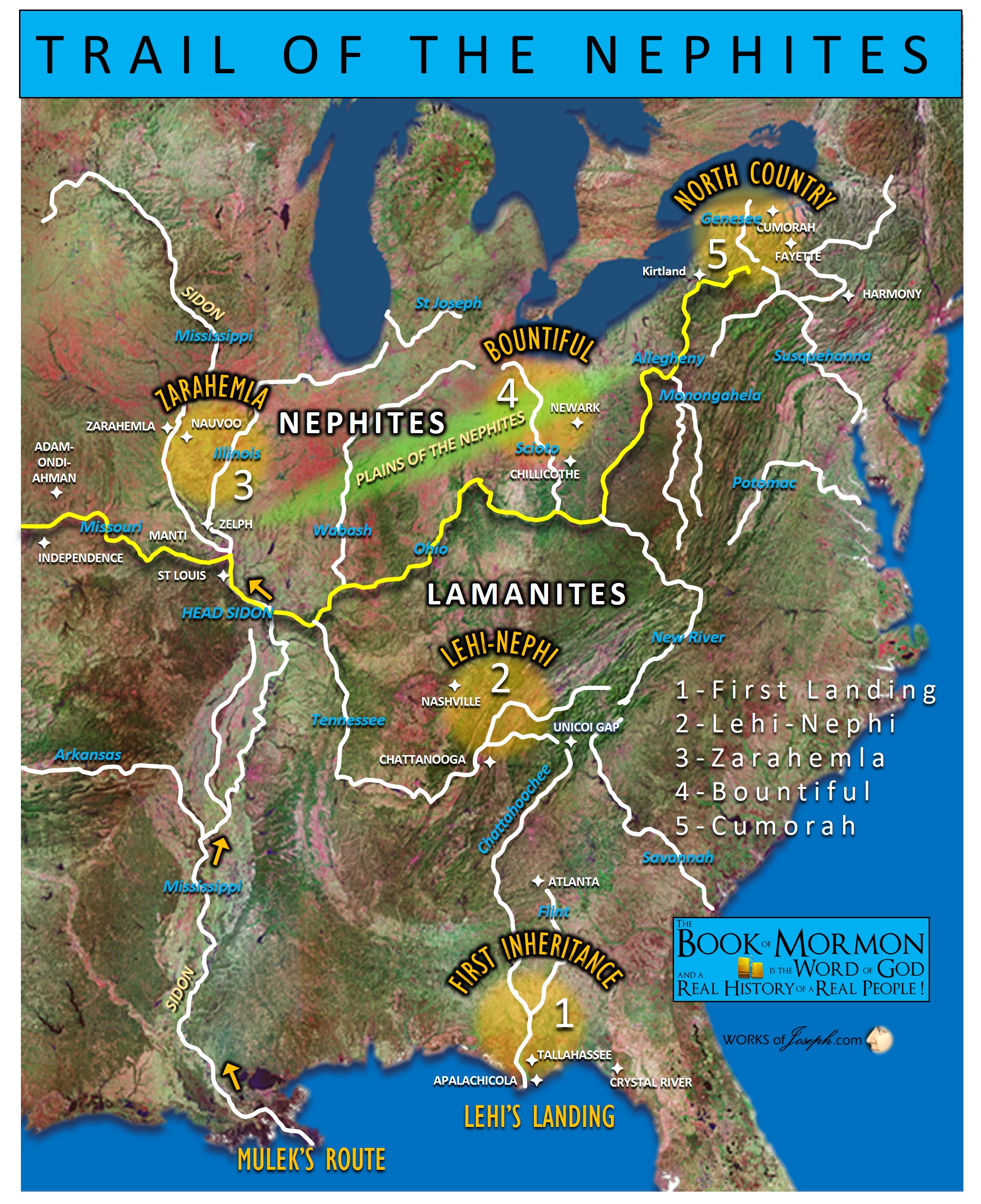
I would like to share things that make sense to me. Of course I believe there was Nephite influence in Mesoamerica but not in the beginning. I just believe the Nephites began in Florida and went to Tennessee, to Missouri to Illinois to Ohio and then to NY Cumorah, where Lamanites remained who were also mixed with other Nephites and Mulekites, as well.
While Lehites and Lamanites first lived in Florida or other parts of the USA, they could have easily migrated west to the western part of the USA area and down to Mexico and to Mesoamerica eventually. I also have read in history that in about 900 AD the Mayans left their homes because of drought or disease, no one really knows, but the Mayans traveled most likely up the Mississippi River and spread all over southeast USA. As our friend Wayne May has said, he spoke with Native Americans who speak of what they called the “Snake People” to describe many Mayans, as these Mayans enslaved the Native Americans and were more powerful than the local Native Americans over 300 years, until the Native Americans regained their stronghold, and the Mayan went back to Mesoamerica. Nephite/Lamanite/Mayan mixtures were known as the Mississippian Culture in the USA from about 900 AD to about 1300 AD. That to me is a big reason that the Native Americans and the Mayans had similarities or mixed as a race.
Most of us seem to understand the period of time of the Adena and the Hopewell, and how they tie into the Jaredites and the Nephites and Mulekites timeline. I will address the mounds in Ohio as likely mounds built by previous Adena and Hopewell Cultures.
Likely the Adena lived from about 1000 BC to 300 AD and the Hopewell from about 200 BC to 500 AD in the Heartland of North America. What are called the Fort Ancient people are the continuation of the Lamanites who defeated the Nephites at Hill Cumorah. The Mississippian are people who came up from Mexico as the Mayans in about 900 Ad to conquer the original Lamanites of North America. These people were called the Snake People by the Lamanites.

After the final battles at Cumorah, we understand the Lamanites survived and the Nephites as an organized Nation became extinct. I am not saying all Nephites were killed, as many did survive. A common belief about the Nephites is its organized nation was destroyed. That doesn’t mean however that every Nephite was destroyed, with no survivors, and the entire race or group ended. However, according to the Book of Mormon, the seed of Nephi, were not completely destroyed.
You will read below some historical information about the important part that Ohio played in the history of the plausibility of the Jaredites and the Nephites it that same location of the Heartland of America.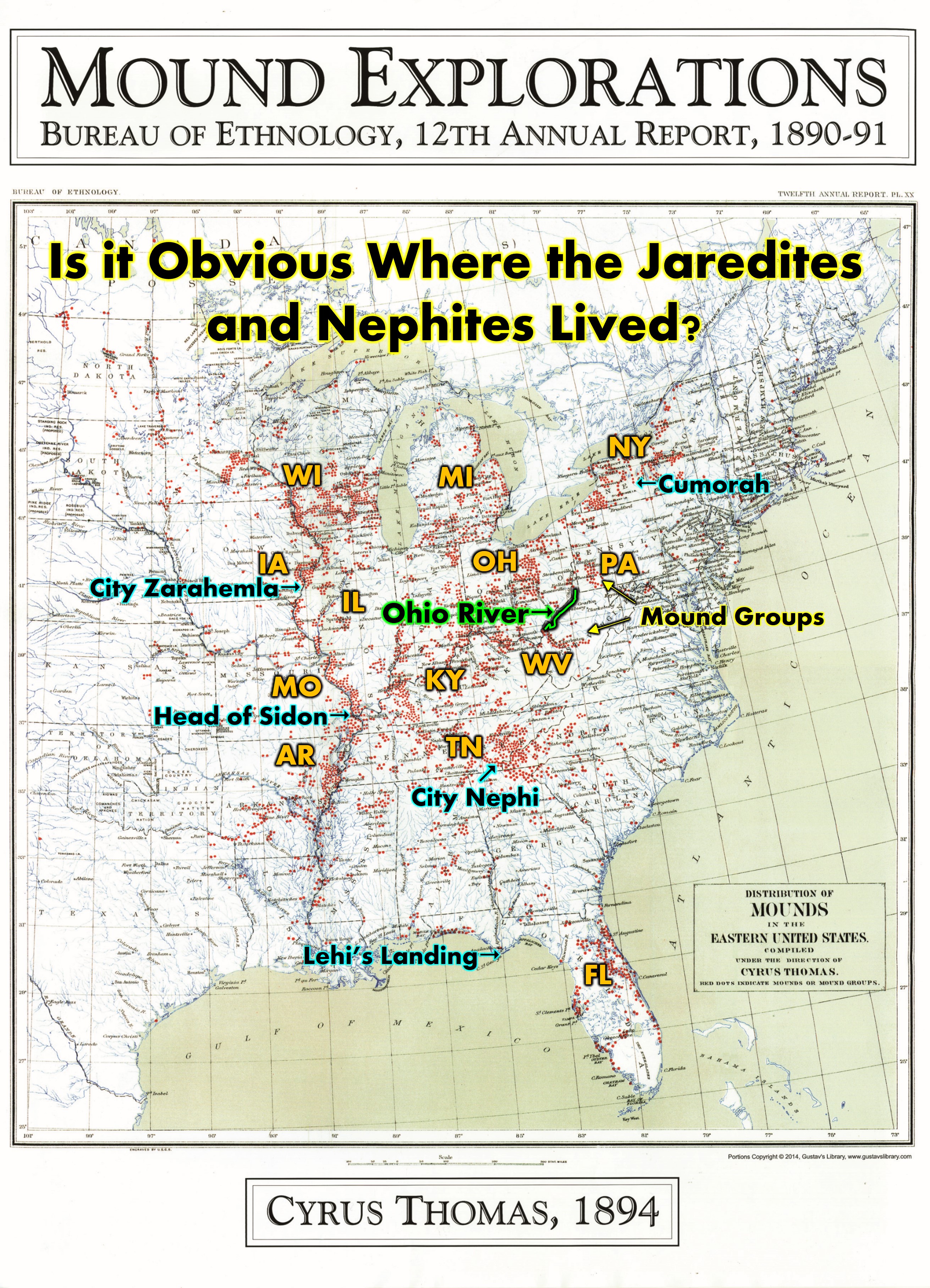
ARCHEOLOGICAL ATLAS OF OHIO by William C. Mills
“The territory embraced within the State of Ohio probably contains a greater number of prehistoric remains than any other equal area in the Mississippi valley. The number of these earthworks has been variously estimated. Some writers have estimated the number of tumuli at 10,000 and the enclosures, etc., at 1,000 to 1,500, making the total number of earthworks more than 11,000, As a matter of fact these estimates were based upon what was known of such counties as Scioto, Ross, Pikaway, Butler, Hamilton, Warren, Washington and Licking, all of which were great centers of prehistoric activity. If all the counties in the state were dotted over with the earthworks of prehistory man, as are the counties mentioned, the estimate would be inadequate. But we find the entire northwest part of the state unsuited in prehistory times for occupancy by a prehistoric people, as the greater portion was low and swampy and at certain seasons of the year covered with water. Again the southeast part of the state was entirely too rough and hilly and the valleys of the streams small, so that agriculture was carried on with great difficulty. The valleys of the two Miamis, Scioto and Muskingum were well adapted for the abode of prehistoric man and here we find his principal monuments.”
Preface, ARCHEOLOGICAL ATLAS OF OHIO Showing the Distribution of the Various Classes of Prehistoric Remains in the State WITH A MAP OF THE PRINCIPAL INDIAN TRAILS AND TOWNS. By WILLIAM C. MILLS https://archive.org/details/ArcheologicalAtlasOfOhio/mode/2up
BEYOND SQUIER AND DAVIS: REDISCOVERING OHIO’S EARTHWORKS USING GEOPHYSICAL REMOTE SENSING
Jarrod Burks and Robert A. Cook
“The prehistoric earthworks of Ohio have played a major role in the development of American archaeology and they continue to figure prominently in archaeological research. However, while a select group of larger earthwork sites have been intensively studied and resurveyed with geophysical survey instruments, much of the ongoing earthwork research, and reference to less-well-known sites, still relies on nineteenth- and early twentieth-century maps. In this article, we present the results of magnetic gradient surveys at three earthwork complexes in south central Ohio. Though much degraded by agricultural plowing and other historic impacts, our survey results show that despite near invisibility at the surface, Ohio’s earthwork sites are (1) readily detected in geophysical surveys, (2) more complex than most early maps suggest, and (3) more numerous and varied than once thought. Given the major role these sites have taken on in studies that explore topics ranging from community structure and burial ceremonialism to population mobility and the development of socioeconomic complexity, a radical redrafting of the nineteenth-century maps could have far-reaching implications in the study of Woodland period (specifically, ca. 300 B.C.-A.D. 500) cultures in the Midwest U.S.”
…Ohio is well known for its many prehistoric earthwork sites. These range from vast earthwork complexes covering well over a hundred acres, like the Newark Works and the less-known Portsmouth Group, to lone small circles, some not more than twenty meters across. Remarkably, nearly all of the region’s earthworks were built between about 400 B.C. and A.D. 400 and are associated with what archaeologists have referred to over the last one hundred years as the Adena and Hopewell cultures.[Jaredite and Nephite] Figure 1 shows the locations of nearly 600 earthwork sites recorded in the Archaeological Atlas of Ohio (Mills 1914). While the digital elevation model is relatively new, the distributional map of earth- works has changed little over the last 100 years (cf. Dancey 1984). Many of Ohio’s earthworks have figured very prominently in the development of American archaeology, as exemplified in the nineteenth century by Atwater (1820), MacLean (1879), Squier and Davis (1848), Thomas (1894), and Whittlesey (1850).” 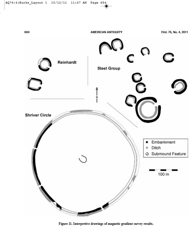
Conclusions
The work of investigation has been just commenced; its future progress may, and no doubt will, result in new and perhaps more important disclosures than any hitherto made [Squier and Davis 1848:xxxix]. Obtaining the bigger picture of complex sites through remote sensing is not a problem unique to Hopewell archaeology. In other regions archaeologists are now relying on a variety of different kinds of remote sensing data to do the same: in England magnetic gradient surveys are laying bare entire Roman cities (Gaffney et al. 2000), in the rainforests of Belize LiDAR data are revealing the shrouded secrets of the Maya city of Cara- col (Chase et al. 2011), and in many parts of the world new aerial imagery accessible via the Internet, Google Earth, and other sources is resulting in a rapid pace of site discovery on a landscape scale (e.g., Pärssinen et al. 2009; Thomas et al. 2008). The maps made of Ohio earthworks in the nineteenth century with chain and compass are still today used by archaeologists as a primary data resource. Without these maps, many of these sites would never have been known to exist. How- ever, hundreds of earthwork sites were never mapped. Early aerial photography beginning in the 1930s produced amazing new images of earthworks and even detected sites previously unknown (e.g., Reeves 1936a, 1936b). In fact, the Anderson Works, a fairly large square enclosure, was found independently by two researchers in aerial photographs as recently as just a few decades ago (Anderson 1980; Pickard and Weinberger 2009). New topographic data collected for the entire state using LiDAR is an exciting new resource that, while perhaps unlikely to lead to the discovery of many new earthwork sites, is making it easier to locate sites that have become lost or have been mislocated. The biggest benefit of the new LiDAR data is that it allows us to visualize these often complex earthwork sites on the landscape and take fairly accurate measurements of their dimensions without having to collect new field data. Trying to find these earthwork sites among the many gigabytes of data is a further challenge, one we hope to one day solve with a publically accessible database of terrain models for many of the sites. Most exciting for earthwork studies is the growing body of geophysical surveys, nearly all of which have revealed important new aspects of these sites not observable in any of the other available maps, images, and datasets (Figure 11). From new enclosure shapes and gateways to entirely new earthwork complexes, geo-physical survey is considerably refining our view of the earthworks of Ohio, rediscovering them in
ways never imagined by early pioneers such as Squier and Davis.” BEYOND SQUIER AND DAVIS: REDISCOVERING OHIO’S EARTHWORKS USING GEOPHYSICAL REMOTE SENSING Jarrod Burks and Robert A. Cook https://www.academia.edu/11784679/Beyond_Squier_and_Davis_Rediscovering_Ohios_Earthworks_Using_Geophysical_Remote_Sensing?email_work_card=view-paper
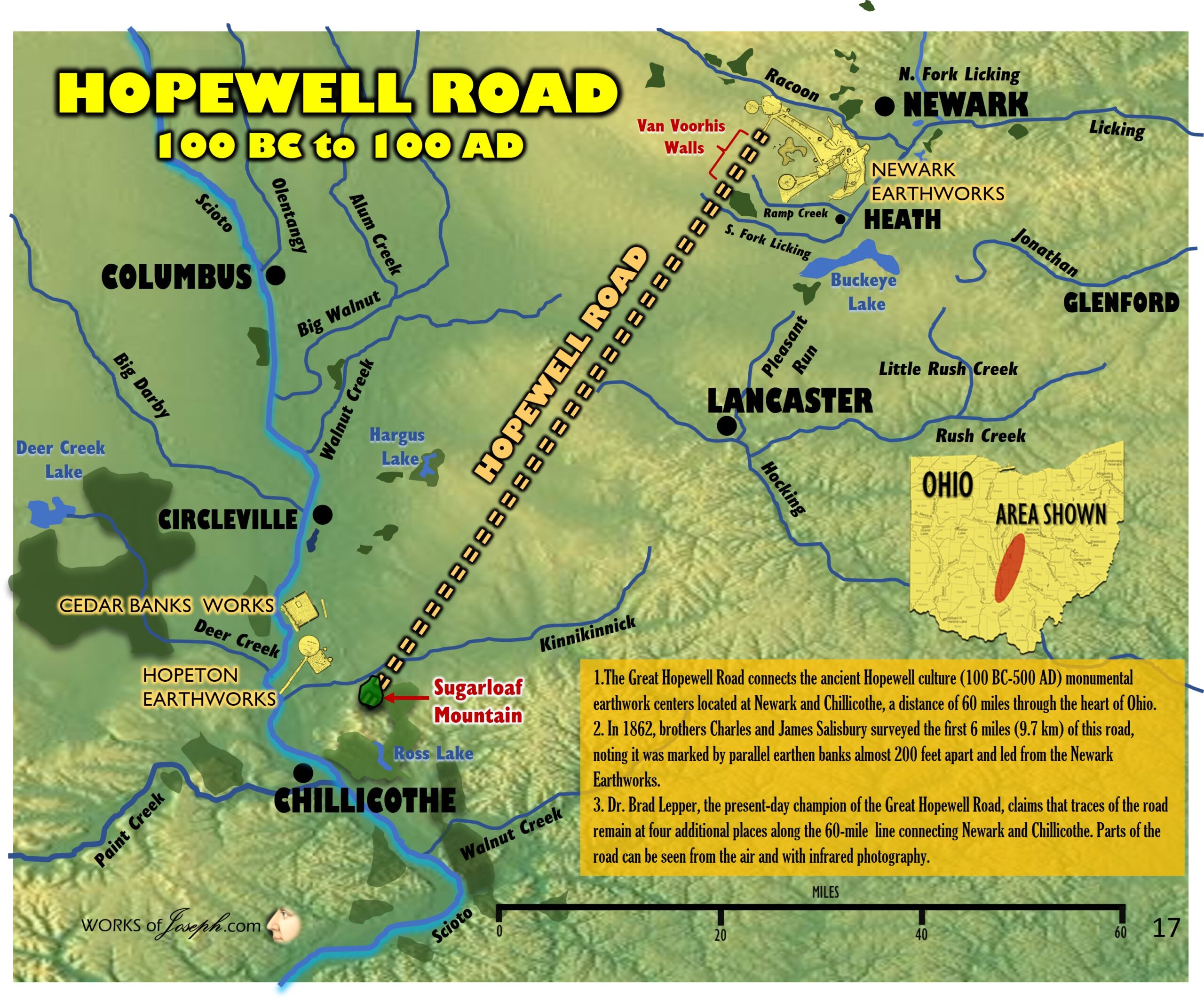
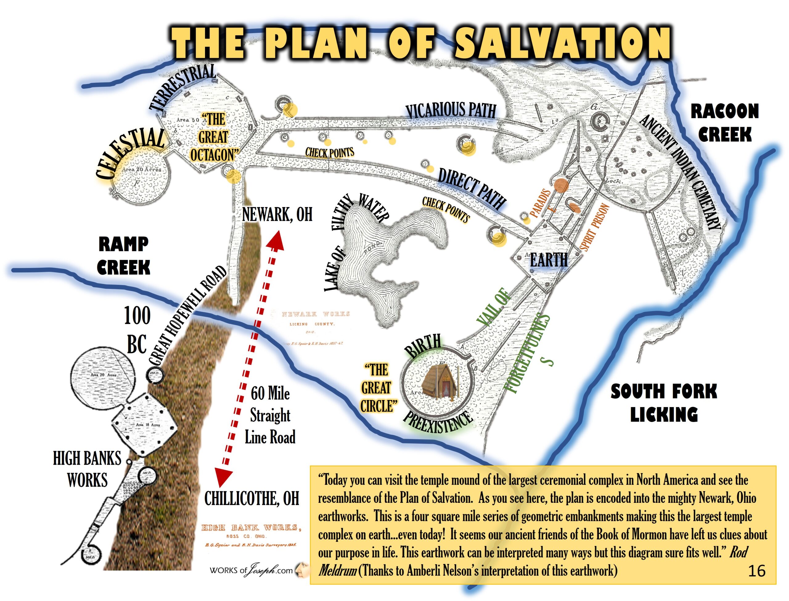
Below is much more history and archaeological verification of mounds all over Ohio. The map below is from Newark, Ohio which to me shows the complete Plan of Salvation which the ancients built as a place of sanctuary. I believe Ohio is also the likely place that Christ visited the Nephites after His resurrection in the Old World. Contact me for additional blogs for more information at: [email protected].
Middle Ohio Valley Prehistoric Archaeology
https://www.academia.edu/Documents/in/Middle_Ohio_Valley_Prehistoric_Archaeology?swp=tc-ri-35604374
The First Settlers: Native Peoples of the Vermilion Watershed
https://www.academia.edu/143917513/The_First_Settlers_Native_Peoples_of_the_Vermilion_Watershed
Comments on the Portsmouth “Indian Head” Rock
https://www.academia.edu/129442714/Comments_on_the_Portsmouth_Indian_Head_Rock
All Articles
https://www.academia.edu/Documents/in/Middle_Ohio_Valley_Prehistoric_Archaeology?swp=tc-ri-35604374