
NOVEMBER EXPEDITION 2021, MONTROSE, IOWA Information Now

MAGNETIC SIGNATURES IN GROUND FROM ANCIENT FIRES
First, we are looking for Zarahemla. That is a clear statement required for a thesis. Nothing wrong here. Second, we know where to look. We are looking at the site that the Lord identified by Revelation to Joseph Smith as Zarahemla. This then is the test of that hypothesis. Nothing wrong with that approach. We are looking for a confirmation of the truth of the Lord’s statement to the Prophet Joseph Smith. Our methods are clear. We know that ancient people kept fires to cook their food, to heat their homes and to bring light to dark places. We know that the heat from these fires changed the magnetic signatures of soil and rock. These changes can be measured with a magnetometer. The SENSYS equipment can survey 100 acres per day within grids that are 1/4″ x 1/4″. Each data point will have GPS coordinates and will measure differences in magnetic forces by +/- 1nT (nanotesla). These readings will be able to identify the location of old fire pits.
The Book of Mormon informs us that in AD 320 there was a Nephite army from the Land of Zarahemla that had 30,000 men. Taking that number as our best indicator, we estimate that the population of Zarahemla was at least 100,000 people. We can find fire pits. We believe that there should be one fire pit for every 10 people or that within a mile or so of the city’s center there would have been 10,000 fire pits. We know that German technology has worked very well on several sites including Stonehenge. We have our own experience with SENSYS from the mounds of Ohio. If we can find anything, we can find fire pits that were kept 1,600 years ago. I like science and I am willing to pay for it. If you can make improvements to our research, I welcome your informed opinion and not just off the cuff speculations. We expect that God’s ancient promises will be fulfilled — “the truth shall spring out of the earth”.
The Lost City of Zarahemla – (Book)
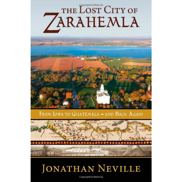
$19.95 $17.49 The Lost City of Zarahemla is destined to become one of the most important discoveries in church history in decades… the definitive answer to the question of Joseph Smith’s knowledge of Book of Mormon geography and the origins of Central American theories. An attorney, novelist, and careful scholar, Jonathan Neville has created a historical account that reads like a first-rate novel. Discover the ‘smoking gun’ of Book of Mormon geography…his name? Winchester. 362 pgs
IMPORTANT CITATIONS
Words from Jesus Christ
“Let them build up a city unto my name upon the land opposite the city of Nauvoo, and let the name of Zarahemla be named upon it.” Doctrine & Covenants 125:3
Prophet Ezra Taft Benson
“This was the place of three former civilizations: that of Adam, that of the Jaredites, and that of the Nephites.” The Teachings of Ezra Taft Benson pp. 587-588
Joseph Smith Papers
“A considerable number of the Sac & Fox Indians have been for several days encamped in the neighborhood of Montrose {Zarahemla}. The ferryman this morning brought over a great number on the Ferry boat and two Flatboats for the purpose of visiting me. The Military band and a detachment of Invincibles were on shore ready to receive & escort them to the grove, but they refused to come onshore until I went down.?> I accordingly went down, and met ‘Keokuk,” “Kish-Ku-Kosh,” “Appanoose,” and about 100 Chiefs and Braves of those tribes with their families at the landing, introduced my brother Hyrum [Smith] to them, and after the usual salutations, conducted them to the meeting ground in the grove, and instructed them in many things which the Lord had revealed unto me concerning their Fathers, and the promises that were made concerning them in the Book of Mormon;” Keokuk – Joseph Smith Papers – August 12, 1841
Crossing Mississippi on Horse – August 11, 1842
“A report came over the river that there is a several small companies of men in Montrose, Nashville, Keokuk, etc., in search of Joseph. They saw his horse go down the river yesterday and was confident he was on that side. The Mississippi River was shallow enough on this late summer day to ride a horse across it at this location.” Exploring the Book of Mormon in America’s Heartland pg 80-81. by Rod Meldrum
CROSSING THE RIVER SIDON
by Valerie Steimle
In our search for physical evidence of the Book of Mormon lands in the United States, we need to start with Zarahemla and the River Sidon. From 600 BC to 400 AD, the Book of Mormon lands were described in the book itself. Zarahemla was the largest city in the area and according to https://zarahemla.site/that-great-city “the most frequently mentioned place by name in the Book of Mormon.”
The U.S. Geological Survey tells us that the Mississippi River is one of the world’s largest river systems. It is made up of several large tributaries making it the largest river and river system in North America. It flows 2,340 miles from its source at Lake Itasca through the midcontinent of the United States all the way to the Gulf of Mexico passing by New Orleans.
From the National Park Service River Facts, the name “Mississippi” comes from the Anishinabe people (Ojibwe Indians.) They called the river “Messipi” or “Mee-zee-see-bee,” which means “Big River” or “Father of Waters.” Dakota Indians called the river “Hahawakpa,” meaning “River of the Falls” in reference to the falls we now call the Falls of St. Anthony.” (https://www.nps.gov/miss/learn/education/upload/brjfact.pdf)
So what does the River Sidon have to do with the Mississippi River and Zarahemla?
First, we learn the word Sidon is the Greek name which means “fishery” for the ancient Phoenician port city of Sidonia which is now Lebanon. Many Native Americans have considered this river a great resource for fish.
We read about Prophet Joseph Smith receiving a revelation from God which is written in the Doctrine and Covenants, section 125 in verse 3:
“3 Let them build up a city unto my name upon the land opposite the city of Nauvoo, and let the name of Zarahemla be named upon it.” Interestingly enough, the word Zarahemla in this verse has a cross-reference to Omni 1:14 in the Book of Mormon which says:
14 “And they discovered a people, who were called the people of Zarahemla. Now, there was great rejoicing among the people of Zarahemla; and also Zarahemla did rejoice exceedingly, because the Lord had sent the people of Mosiah with the plates of brass which contained the record of the Jews.”
For years and years, the Heartland theory has matched the River Sidon with the Mississippi River. How is this possible? We read in the Book of Mormon itself that Zarahemla is close to the River Sidon. According to The Book of Mormon, the River Sidon is east of Zarahemla which lines up with what Joseph Smith revealed. It would make sense from a geographical point of view that the River Sidon is the Mississippi River. As more study is done, we find that there is a possibility of finding the place of the war mentioned in Alma.
From Alma chapter 2 verses 27 and 28 and verses 33 through 35, “And behold, as they were crossing the river Sidon, the Lamanites and the Amlicites, being as numerous almost, as it were, as the sands of the sea, came upon them to destroy them.
28 Nevertheless, the Nephites being strengthened by the hand of the Lord, having prayed mightily to him that he would deliver them out of the hands of their enemies, therefore the Lord did hear their cries, and did strengthen them, and the Lamanites and the Amlicites did fall before them.
33 But Alma, with his guards, contended with the guards of the king of the Lamanites until he slew and drove them back.
34 And thus he cleared the ground, or rather the bank, which was on the west of the river Sidon, throwing the bodies of the Lamanites who had been slain into the waters of Sidon, that thereby his people might have room to cross and contend with the Lamanites and the Amlicites on the west side of the river Sidon.
35 And it came to pass that when they had all crossed the river Sidon that the Lamanites and the Amlicites began to flee before them, notwithstanding they were so numerous that they could not be numbered.”
We know that the bodies of the Lamanites who had been slain were tossed into the waters of the River Sidon. We just have to find it. An exciting event will be taking place during the first week of August of this year on the Mississippi River. A group of more than 15 professionals in science and engineering will be joining together to search for this spot. A 32-foot Pontoon Mississippi Riverboat named “Truth” is being outfitted for this expedition. Surveys of this land and river area are being studied. Advanced sonar scanning using SENSYS technology and military-trained scuba diving will be used to see and chart the river bottom. Hold onto your hats as all of these preparations are taking place to find the crossing of the River Sidon.
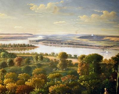
Hill Amnihu 87 B.C. from Zarahemla side on Sidon River, Nauvoo Temple 1844 A.D. from Montrose.
OPENING A NEW PAGE FOR THE BOOK OF MORMON
Welcome to the evidence-based search for the Lost City of Zarahemla!
While the geography of the Bible is established with maps showing the location of important biblical events, the Book of Mormon is often mocked by critics as fiction because it lacks concrete geography. But the times are changing.
Imagine finding the largest ancient city of the United States that existed over 2,000 years ago. What treasures would we find of the ancient inhabitants during the time of the Book of Mormon?
In the first week of August 2020, the Heartland Research Group is opening a new page for the history and geography of the Book of Mormon. Using a riverboat with advanced scanning technologies that have never before been used for this type of search, we intent to confirm the place for crossing the River Sidon. This is a big piece in the puzzle for nailing down the location of Zarahemla on the west bank of the Mississippi.
Our location was inadvertently identified by the young military officer Robert E. Lee in his 1837 Survey of the Des Moines Rapids. After this survey came to our attention, we saw that it matched perfectly with the account from the Book of Mormon. Using modern technology, we will be able to make scans that are 1000x more detailed than Lee’s 19th century survey.
We will scan the riverbed to find shallow places that were crossed by large armies on foot as reported in chapter two of the Book of Alma. For example, the battle of 60,000 warriors happened mostly on the west bank of the River Sidon, but much of the fighting was also in the water.
There is no other large river in North America that could have been crossed in the manner that is so carefully recorded for the Battle of Zarahemla. Near this crossing , there are Native American artifacts and earthworks that were part of the culture and religious life of the people who lived 2,000 years ago. Our mission in August is to establish the geography of the Book of Mormon so that you will have tangible proof of its place and time. Eventually we want to provide indisputable physical evidence for the story of Jesus Christ in America.
Our first donor has given us the use of his boat. Now we need to buy equipment for scanning the bottom of the river. Our total cost will be $12,000 to complete a digital mapping of the river bottom. We need your help. Please donate any amount or any equipment so we can do this important research this summer and provide you additional evidence for the Book of Mormon.
Details of the search:
When we find the place where Alma’s army crossed the River Sidon in the harvest time of 87 B.C., we will have evidence that we are in the neighborhood of the ancient city of Zarahemla. Since the construction of the river’s first dam in 1913 at Keokuk, Iowa, Alma’s crossing has been buried under 15 feet of water. At the crossing, the river is one mile wide.
Our platform for the underwater search is Jeff Green’s 32-foot pontoon Mississippi riverboat. From this boat, we will dive into the water to find the horizontal limestone ledge of the Keokuk Gorge over which Alma’s army walked when they crossed the river. After finding this geological formation, we will know that we have found the place of crossing.
How do we know where to search on a river that is more than 2,000 miles long? We can thank Robert E. Lee for his September 1837 Survey of the Des Moines Rapids in the Keokuk Gorge. His survey marks the point on a chart that shows where the flow of the river’s water at harvest time would have been sufficiently low so as to allow an ancient army to ford the large river. After confirming the crossing, we will locate the city of Zarahemla whose site was largely determined by the geological formations that force the mighty Mississippi to flow through the Keokuk Gorge.
In five days of boating, we can chart 200 feet x 5000 feet of the river bottom by advanced sonar scanning and military-trained scuba diving. These scans will be critical for the magnetic scanning of the city of Zarahemla with SENSYS technology that is discussed in-depth on this page https://zarahemla.site/sensys-technology
SPRINGING OUT OF THE EARTH
With the tools of modern science, the proof of the lost city is coming out of the ground. We have already searched in ways that our fathers could never imagine. In November 2020, we took the SENSYS MX V3 equipment from Germany to Montrose, Iowa’s cornfields, to places that God through His Prophet identified as Zarahemla. We found traces of 1,000’s of ancient fire pits revealed as magnetic images — these images are outlining North America’s largest 4th-century city.
Zarahemla’s long-promised unveiling is happening in our time with a technology that is comparable to an MRI scan. The lost city is coming out of the dust, fulfilling prophecies in the Book of Mormon and the Old Testament.
In January 2021, scientists at the Vilnius Radiocarbon Laboratory are dating 15 samples of ancient charcoal with the Accelerator Mass Spectrometer. The decay of Carbon-14 isotopes makes it possible to fix the age of the fire pits on the world’s timeline.
These dates are in alignment with the chronology of Zarahemla as found in the Book of Mormon.
The Lost City Zarahemla – Expedition 1
The Lost City Zarahemla – Expedition 2
True Map of the Book of Mormon Lands
To assist Heartland Research please donate here:

To See more maps here. To purchase maps click here:
