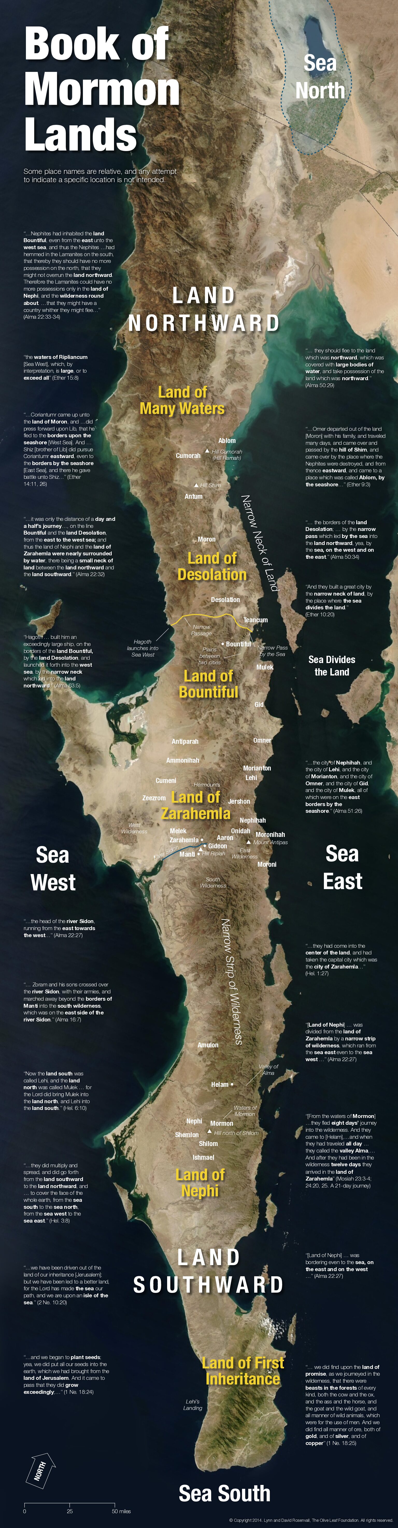
We take the opportunity to share with you some information about the Baja Theory of Book of Mormon geography. Like I have said in the past we respect all those who share their opinions of geography. David Rosenvall has been sharing the Baja Theory for many years now and he is a good man and I’m sure a great member of the Church. I just disagree with him especially about Cumorah.
So the promised land is the Baja? Is that where Cumorah is and the Garden of Eden? Northern Baja is at 30 degrees latitude and so is Jerusalem, so seeds from Jerusalem would grow in Northern Baja, correct? That is a good point. Did you know that Florida is also at 30 degrees? Elder Perry said, “The United States is the promised land foretold in the Book of Mormon—a place where divine guidance directed inspired men to create the conditions necessary for the Restoration of the gospel of Jesus Christ.” Elder L. Tom Perry Ensign Dec. 2012.
David Rosenvall’s Baja Theory of the Book of Mormon
David Rosenvall’s Baja Theory is a controversial geographical model proposing that the events of the Book of Mormon took place primarily on the Baja California Peninsula rather than in Mesoamerica or the U.S. heartland gospeltangents.com
Summary of Why Baja is Unlikely for the Book of Mormon
According to the Baja Theory, Lehi landed in the southern part of the Baja Peninsula. That would be about 20 to 22 degrees latitude. The seeds brought from Jerusalem by Lehi were at about 30 degrees latitude which would not be good for planting in southern Baja. (It may be for planting in northern Baja), but that is not where Lehi landed. The Baja theory says that the seeds Lehi had gathered before sailing (from Oman) and seeds they likely picked up additionally along the journey to Oman had adapted to a tropical or different climate along the way possibly. We believe the Lehites landed near Tallahassee, or Apalachicola, Florida which are at 29-31 degrees latitude, or perfect for growing Lehi’s seeds from Jerusalem.
Baja Small Rivers, and Creeks and Springs.
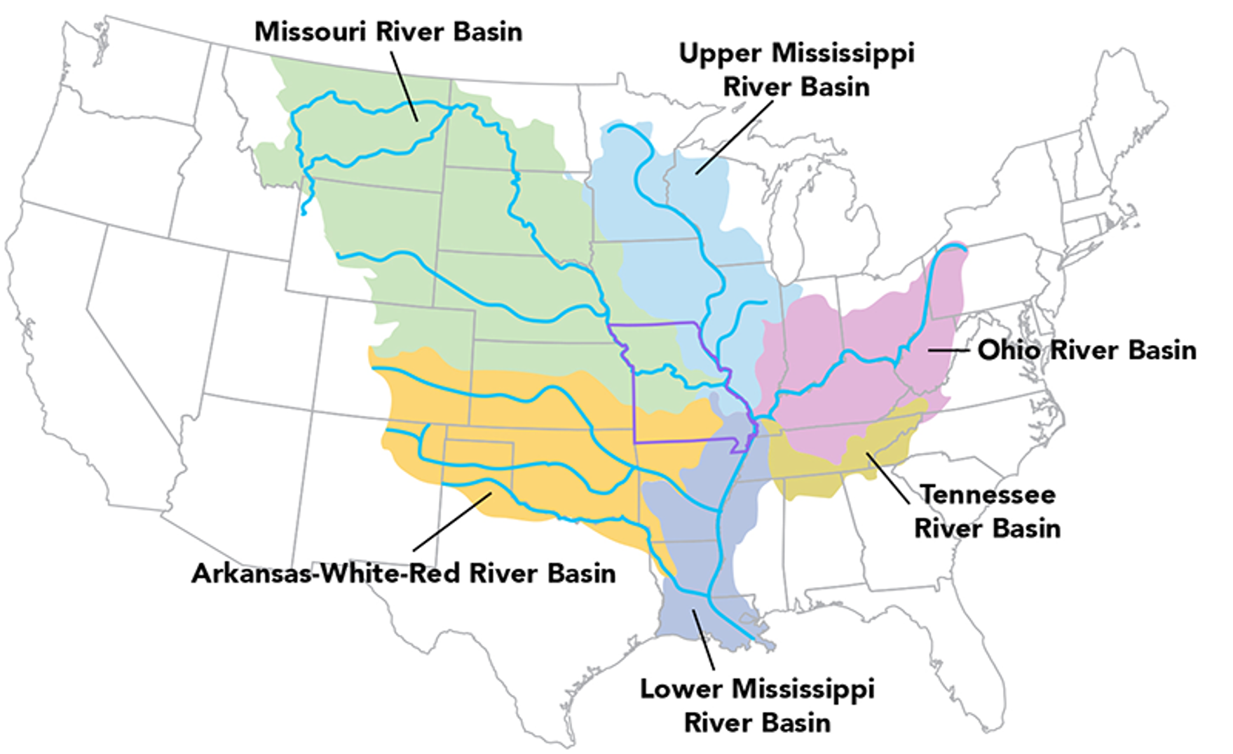
The Mississippi and Ohio basins could feed hundreds of thousands of Nephites and Lamanites. The small valleys and basins in Baja are extremely small.
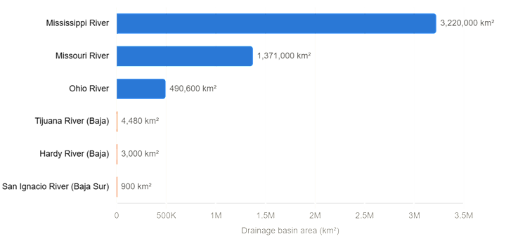
There’s no major river in the ecoregion of Baja aside from a couple of exceptions in California itself, and almost no permanent watercourses anywhere on the peninsula — it’s springs, coastal creeks, and lagoons rather than rivers as most people picture them.
The chart above puts that in perspective: the Mississippi basin (~3.22 million km²) and Missouri basin (~1.37 million km²) each dwarf even Ohio’s basin (~490,600 km²), and all three make Baja’s largest basin — Tijuana River at ~4,480 km² — look like a rounding error. The Mississippi basin alone is roughly 700 times larger than the entire Tijuana watershed.
Baja California’s peninsula is famously arid — it doesn’t have anything like a “river” in the Ohio/Mississippi/Missouri sense. What exists are mostly seasonal arroyos that only run during rare rains. Source
Here are the dimensions of the Baja California Peninsula:
- Narrowest point: About 40 km (25 miles) wide at its narrowest point, near La Paz, Baja California Sur. That’s approximately 132,000 feet. Justapedia
- Widest point: About 320 km (199–200 miles) wide at its widest point. That’s roughly 1,051,200 feet. Justapedia
To put it in perspective, the peninsula narrows to less than ⅛ of its maximum width at its thinnest section — a dramatic taper for a landmass that stretches 775 miles long from Mexicali in the north to Cabo San Lucas in the south. Justapedia
https://claude.ai/chat/9cfcc241-455f-47bf-b5f1-67d613019b80
Origins and Methodology
The theory began with a question from Rosenvall’s father, a university geography professor: Where would seeds from Jerusalem actually grow? Rosenvall realized that Jerusalem’s Mediterranean climate (wet winters, dry summers) is essential for the seeds to “grew exceedingly” as described in the text, ruling out tropical Mesoamerica or cold northern climates gospeltangents.com. This climatological insight led him to focus on the Baja Peninsula’s Mediterranean-like climate.
Rosenvall’s approach is engineering-based, modeling the Book of Mormon’s 33,000+ geographical statements against physical geography—mountains, rivers, coastlines, and climate—rather than relying solely on cultural or archaeological evidence (“human geography”) gospeltangents.com.
Key Geographic Assignments
According to Rosenvall and his wife Lynn bhroberts.org:
- Land of Nephi – Southern Baja California.
- Land of Zarahemla and Land of Bountiful – Central Baja, with a narrow neck connecting to the north.
- Land of Desolation – Northern Baja, shared by Nephites and Jaredites.
- Cumorah – Northern Baja
The peninsula’s size (over 800 miles), varied terrain, and narrow “neck” features are argued to match the distances and landforms described in the Book of Mormon bhroberts.org.
Comparison to Mesoamerican Theory
Rosenvall critiques the dominant Mesoamerican model (popularized by John L. Sorenson) for focusing on cultural similarities and artifacts, which he says can be rotated to fit the text’s “east” orientation. He argues that Nephite culture likely migrated to Mesoamerica after the destruction of the Nephite nation, explaining why cultural remnants exist there YouTube.
Strengths and Criticisms
Strengths:
- Matches the text’s climate requirements for Jerusalem seeds.
- Uses a systematic, data-driven methodology.
- Offers a varied landscape that could accommodate the Book of Mormon’s scope.
Criticisms:
- Lacks extensive archaeological evidence for Nephite/Jaredite settlements in Baja.
- Some scholars argue the theory overemphasizes physical geography at the expense of cultural and linguistic data.
- The “two Cumorahs” and other specific locations remain challenging to me. They believe the Cumorah in NY is where Joseph found the plates, they just disagree on where the final battles happened somewhere in Northern Baja on a different hill.
- In Baja the DNA is Asian. Near the Great Lakes is Hebrew, Haplogroup X also found in Galilee. https://www.nationalgeographic.com/science/article/131120-science-native-american-people-migration-siberia-genetics]
- Baja does not have the necessary animals or plants to practice the Law of Moses.
- Not enough River Basins to sustain a large Nephite/Lamanite/Jaredite population.
- There is no revelatory language for Baja. There is for Heartland. See Rod Meldrum’s new article titled “Is There a Revealed Book of Mormon Geography?“
Resources
Rosenvall’s ideas are detailed in the Gospel Tangents 2017 interview series and the book The Baja Theory of the Book of Mormon: David Rosenvall Interview gospeltangents.com. These materials compare his theory to Mesoamerican models, discuss DNA, animal species, and other evidence.
In short, Rosenvall’s Baja Theory is a climate- and physical-geography-driven alternative to mainstream Book of Mormon location models, appealing to those who value scientific and environmental consistency in interpreting scripture.
Web Site: http://www.aChoiceLand.com
Lynn and David Rosenvall, Olive Leaf Foundation. All rights reserved. The views expressed are the opinions of the authors and are not intended to represent the position of The Church of Jesus Christ of Latter-day Saints, nor any other organization.
Sidon
Where is Sidon for the Baja Theory?
Arroyo San Ignacio —What’s known: it’s a small, slow-moving spring-fed stream/oasis river that runs through the town of San Ignacio in Baja California Sur, Mexico, moving so slowly it feels more like a giant swimming pool, and is a popular spot for kayaking, swimming, and paddleboarding. It eventually feeds the San Ignacio Lagoon, about 37 miles away. Where the watershed reaches the Pacific lagoon, ~37 miles
What river flows into Laguna San Ignacio and how long is the river and depth?
There’s some conflicting info, but the gist: the lagoon is formed by the Río San Ignacio, which descends from the Sierra de San Francisco and flows south until it reaches Laguna San Ignacio, roughly 40 miles west of the town of San Ignacio. However, one ecotourism source states there is no river input to the lagoon at all, and it’s fed by alluvial sediments with very low annual rainfall — so sources disagree on whether the river’s flow actually reaches the lagoon directly versus mostly disappearing into the desert/aquifer before getting there. AllTrails + 2
No reliable length or depth figures exist for the Río San Ignacio itself — it’s one of only two real rivers in Baja California Sur, but it’s small and slow-moving, more like a fresh body of water that moves so slowly it feels more like a giant swimming pool, rather than a deep, fast-flowing river with surveyed dimensions. Allaboutbaja Sunset Magazine
What is the name of the other river in Baja and how long is it?
The most likely answer is the Río Santa Rosalía (also called Río Santa Rosalía de Mulegé), which empties into the Gulf of California near Mulegé and is one of the few named rivers listed under Rivers of Baja California Sur on Wikipedia. No reliable length figure is available for it either — it’s a small, often-dry desert arroyo-type river, and detailed hydrological measurements (length, depth) don’t appear to be published for either of Baja California Sur’s “two real rivers.” https://claude.ai/chat/e451a9a2-18a6-4ce8-b5dc-1ab26b12324b
Is there much fishing in these two rivers?
Mostly indirectly, and the real fishing action is at the river mouths/lagoons, not the rivers themselves.
Río Santa Rosalía: it’s listed as a fishing spot, most popular for common dolphinfish, Pacific crevalle jack, and spotted sand bass, but the area’s real draw is the Sea of Cortez coastline near Mulegé/Santa Rosalía, famous for grouper, yellowtail, marlin, dorado, and more. Fishbrain
Río San Ignacio / Laguna San Ignacio: the lagoon itself is popular for kayaking rather than fishing, and notably no fishing is allowed in the lagoon during whale season (roughly January–April). Outside that window, light fishing from shore or panga is possible, but it’s not a noted fishing destination compared to the coastal areas. Bloodydecks
In short, these small inland rivers aren’t significant fisheries on their own — the serious sportfishing in the region happens in the Gulf of California/Pacific waters they feed into. https://claude.ai/chat/e451a9a2-18a6-4ce8-b5dc-1ab26b12324b
Cumorah
I don’t have specific sources confirming details of this particular fringe theory readily verified. Let me search for accurate information.
Based on these sources, proponents of the Baja California model generally place the Book of Mormon’s Hill Cumorah near the Colorado River Delta, with one specific proposal identifying it as a hill now known as Cerro Prieto. The Millennial Star
Other versions of the theory don’t pin down an exact modern peak but argue the final battles happened on the Baja peninsula itself, with Moroni later traveling north to bury the plates in New York — described as a “Two Hill” theory, where the final battles occurred at a Hill Cumorah in Baja, and Moroni then spent decades traveling northward to bury the plates near Manchester, New York. Gospel Tangents
So there isn’t one single agreed-upon site — different Baja theorists propose slightly different locations, but Cerro Prieto near the Colorado River Delta is the most specific named candidate. https://claude.ai/chat/e52ba5a0-c33c-4d6c-9d18-14281ba5b0e9
Jonathan Neville about Baja
(i) Oliver and Joseph visited the repository of Nephite records in the hill Cumorah in New York multiple times. When he spoke about this in a conference just two months before he died, President Brigham Young said he did so because he feared the knowledge would otherwise be lost. See https://www.lettervii.com/2025/03/brigham-youngs-prophecy-about-cumorah.html(ii) Oliver and Joseph, along with David Whitmer, met the messenger who, having received the abridged plates from Joseph in Harmony, said he was “going to Cumorah” before he brought the plates of Nephi to Fayette. Joseph identified him as one of the three Nephites.(iii) Lucy Mack Smith reported that the first time he appeared to Joseph Smith, Moroni identified the hill as Cumorah. Thereafter, Joseph referred to the hill as Cumorah and the entire family knew to what he referred, even before he took possession of the plates.(iv) In 1834, the anti-Mormon book Mormonism Unvailed made a series of accusations against the Church, including that the Book of Mormon was fiction. In response, as Assistant President of the Church, and with the assistance of Joseph Smith, Oliver wrote and published the first formal history of the Church, including Letter VII.(v) At the outset of the history he published, Oliver explained that “To do Justice to this subject will require time and space: we therefore ask the forbearance of our readears, assuring them that it shall be founded upon facts.” Throughout the essays, Oliver clearly distinguished between facts and speculation, such as when he explained he did not know how deep Moroni buried the stone box to account for erosion and when he explained that when he asked Joseph how long he prayed before Moroni came, “hours passed unnumbered—how many or how few I know not, neither is he able to inform me; but supposes it must have been eleven or twelve, and perhaps later,”(vi) President Cowdery explicitly declared it is a fact that the hill in New York where Joseph obtained the plates was the same hill called Cumorah/Ramah in the Book of Mormon and that this is the location of the final battles.(vii) After they published Letter VII in the Messenger and Advocate, Joseph had it copied into his own journal as part of his life story where everyone can read it here:
(viii) Joseph had it republished in the Times and Seasons and Gospel Reflector, and it was republished in the Millennial Star, The Prophet, and later in the Improvement Era.(ix) While many Church leaders have reaffirmed the New York Cumorah (such as President Romney in General Conference in 1975), no Church leader has ever repudiated what President Cowdery wrote in Letter VII.

Cast Up
by Jonathan Neville
More on Baja: highways “cast up”
“The Baja advocates recently gave us a good example of how bias confirmation works. In this case, the Stick of Joseph podcast made a video about “highways” in Baja that supposedly match the Book of Mormon. https://www.youtube.com/watch?v=OTbk0domTs8
The Baja advocates had an obvious problem in Baja. The rudimentary roads throughout the peninsula are basically ruts through the desert, in some cases cleared of large rocks.
The Book of Mormon refers to highways in one verse:
“And there were many highways cast up, and many roads made, which led from city to city, and from land to land, and from place to place.” (3 Nephi 6:8)

_____
Before reading the transcript, let’s review bias confirmation again.
The Baja theory is a good example of multiple working hypotheses, which is great. I encourage everyone to propose new ideas, pending more information.
At the same time, the pursuit of clarity, charity and understanding requires us to start with clarity.
In this case, we start with the underlying premise of the Baja theory, which, like M2C, is that Oliver Cowdery lied about Cumorah/Ramah in New York.
We can all read Letter VII, as well as Letter IV, Lucy Mack Smith’s history, Parley P. Pratt’s account, David Whitmer’s account, Brigham Young’s account, and all the rest. As well as D&C 128:20.
The FAITH model starts with “Facts.”
The existence of these sources are facts that everyone who knows about them accepts as authentic. Most Latter-day Saints don’t know about them because the popular scholars and those who promote them avoid these sources.
As we will see in the video below.
The second step in the FAITH model is “Assumptions.”
For these steps, we make assumptions about the historical facts. We can assume either that
(i) Oliver et al told the truth, or
(ii) Oliver et al did not tell the truth.
The Baja advocates, like the M2C advocates, assume that Oliver did not tell the truth. Instead, they claim all of these sources related a false narrative, and that Joseph Smith himself adopted this false narrative.
Which is why we have this divergence, right from the outset.

_____
Here’s the transcript.
Hayden Paul: But there is one thing I have to point out. You know, in that scripture, it talks about uh the roads being cast up.
Rosenvall: Yeah.
Right. And I’ve always thought of it this way. That that means taking rocks and putting them on top. So the road is elevated and that’s not what we’re seeing here. What we’re seeing is rocks cleared off to the side and kind of almost creating a barrier.
That’s right.
To go on the road. So explain where does that come from?
Where does that come from? Cuz it doesn’t seem to match.
Yeah. So our normal modern day lens is that casting up on top of each other.
Biblically, especially in Isaiah, there’s a couple of references that talk about this, but what it meant is to remove obstacles, to put the stones to the side that you can create. They use the word standard. This is where you can follow to get somewhere. In fact, they used it spiritually. Remove the sins from your life.
Here’s this. Here’s the path to get back to God. So, it’s clearly removing, not adding.
What are these references? Cuz we got to fact check here. So, in Isaiah, there’s a couple. There’s one in Isaiah 62:10.
Pull, let me pull that up. Okay, I’ve got it. Verse 10, it says, “Go through, go through the gates. Prepare ye the way of the people. Cast up. Cast up the highway, gather out the stones, lift up a standard for the people.
Okay. All right. I’m seeing that. Yeah.
So, to cast up the highway means lift off the stones. That’s right. Okay. What’s the next one?
57:14. Isaiah 57:14. It says, “And shall say, cast ye up.” Cast ye up. Prepare the way. Take up the stumbling block out of the way of my people. So, right there, it’s even more clear. It’s saying, “Cast up. Cast up. remove the stumbling block from the people, make the path clear. And what’s so curious, oh, that’s way different.
Zoom out and we’ll splice in some drone footage here, but you zoom out and basically what you see is just rocks lining these roads for miles and miles and miles. And obviously today we see a lot of rain wash through these through these ancient roads. But it doesn’t take away the fact that for miles you just see these straight roads cast up, meaning all the rocks. aside.
So now, to make Baja confirm their bias, the Rosenvalls have to say “cast up” doesn’t mean “build up,” which is the literal Hebrew terminology. https://biblehub.com/interlinear/isaiah/62-10.htm
Anyone reading these verses in Isaiah might think they refer to two-step process. First, build up the road. Second, remove any stones that hinder passage.
I asked AI about it.
In Isaiah 62:10, the text gives us a remarkably vivid, accurate snapshot of exactly how ancient Middle Eastern road crews prepared a highway for a king or a massive caravan.
The verse reads:
“Pass through, pass through the gates! Prepare the way for the people. Build up, build up the highway! Remove the stones. Raise a banner for the nations.”
When you unpack the specific phrases used in this verse, it aligns perfectly with the archaeological reality of how dirt and gravel roads were constructed and maintained in the region.
The Three Steps of Ancient Road Building
The verse breaks down the three core tasks required to make a rugged desert track usable for a massive crowd:
1. “Build up, build up the highway!” Ancient roads outside of major cities were rarely dug deep into the earth; instead, they were elevated. Road builders would pile up earth, clay, and gravel to create an embankment (often called a causeway). This achieved two vital engineering goals: it created a relatively flat surface over uneven, dip-filled terrain, and it ensured that during flash floods, water would drain off to the sides rather than washing the road away.
2. “Remove the stones.” The terrain of the Levant and broader Middle East is notoriously rocky, littered with limestone and flint boulders. For a smooth journey—especially for people traveling on foot, in sandals, or leading pack animals and wheeled carts—the track had to be meticulously cleared. Workers physically cast aside large rocks to the edges of the path, which often served a dual purpose as crude boundary markers for the road itself.
3. “Raise a banner for the nations.” Because the vast desert and wilderness landscapes could easily disorient travelers, ancient highways used landmarks, stone cairns (piles of rocks), or literal flags and banners at high points. These served as ancient GPS markers, guiding travelers from afar and signaling that they were on the official, safe, and maintained imperial route.
In short, Isaiah 62:10 isn’t just using poetic imagery; it is using the literal language of an ancient public works project to describe a path being cleared of all obstacles.
That seems obvious enough, but let’s also look at how the Book of Mormon uses the term “cast up.”
2 And behold, the city had been rebuilt, and Moroni had stationed an army by the borders of the city, and they had cast up dirt round about to shield them from the arrows and the stones of the Lamanites; for behold, they fought with stones and with arrows. (Alma 49:2)
And he caused that they should build a breastwork of timbers upon the inner bank of the ditch; and they cast up dirt out of the ditch against the breastwork of timbers; and thus they did cause the Lamanites to labor until they had encircled the city of Bountiful round about with a strong wall of timbers and earth, to an exceeding height. (Alma 53:4)
 |
| Imagine trying to cast up dirt and earth against timbers in such a rocky, barren terrain as Baja. |
…when they heard this they cast up their eyes as if to behold from whence the voice came;(Helaman 5:48)
23 And they did work in all manner of ore, and they did make gold, and silver, and iron, and brass, and all manner of metals; and they did dig it out of the earth; wherefore, they did cast up mighty heaps of earth to get ore, of gold, and of silver, and of iron, and of copper. And they did work all manner of fine work. (Ether 10:23)
The sole anomaly is the highway passage in 3 Nephi 6:8 where “cast up,” according to the Rosenvalls, does not mean to create an embankment but to clear stones. And yet, that anomaly is contradicted even by the Isaiah passages they cite.
Plus, the highway described in 3 Nephi 6:8 fits the Great Hopewell Road, contrary to the tracks in the Baja desert.
None of this was brought up in the Stick of Joseph video here: https://www.youtube.com/watch?v=KR9iAsqVnmM
But it should have been.” Jonathan Neville https://www.lettervii.com/2026/06/more-on-baja-highways-cast-up.html?utm_source=follow.it
Again we just share information and it is up to you to decide. We all love the Book of Mormon whether we can agree about geography or not.