
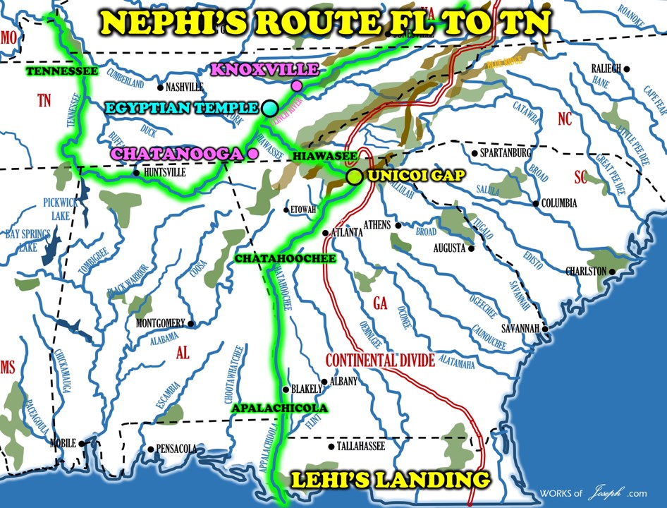
Nephi Travels from Tallahassee to Unicoi Gap to Chattanooga
(Follow Map Below)
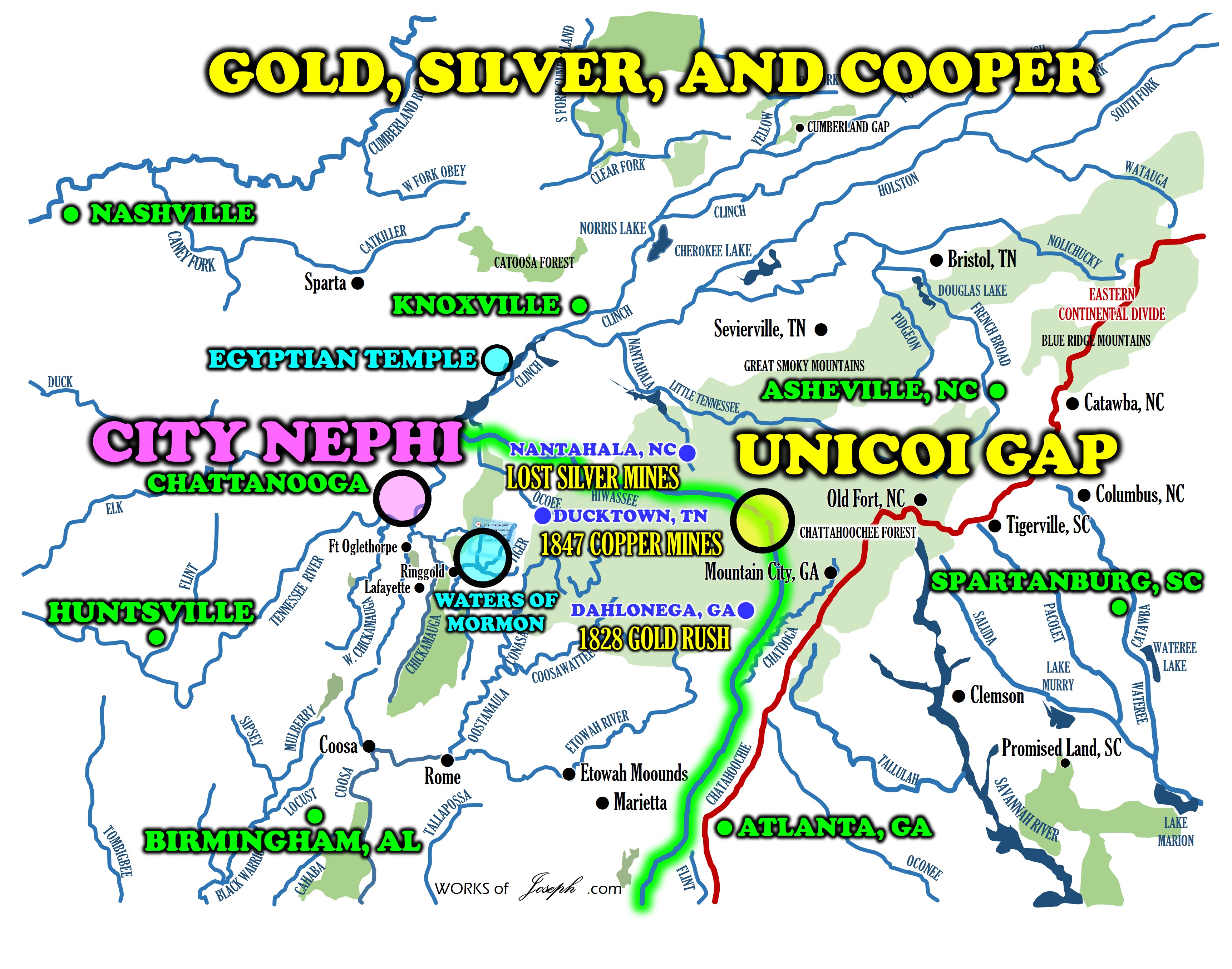
At the Head or beginning of the Chattahoochee River (1) at Unicoi Gap, only 1,700 feet away is the Head or beginning of the Hiawassee River. (2) After Nephi came from the Tallahassee, FL (3) area on the Chattahoochee he traveled “many days” as the scriptures say. That would be about 9 days by canoe from Tallahassee to Unicoi Gap GA (4) where I propose Nephi’s Valley (5) could have been. Just a few hundred feet away, Nephi could have taken the next few days by canoe on the Hiawassee River(6) to the Tennessee River (7) flowing with the river into Chattanooga (8) which we propose is the City Lehi-Nephi. (9) The First Temple could have been built on Lookout (10) in Chattanooga some 2,400 feet above the city. I propose the water of Mormon could be at Catoosa Springs(11) or at Crawfish Springs (12) Rian Nelson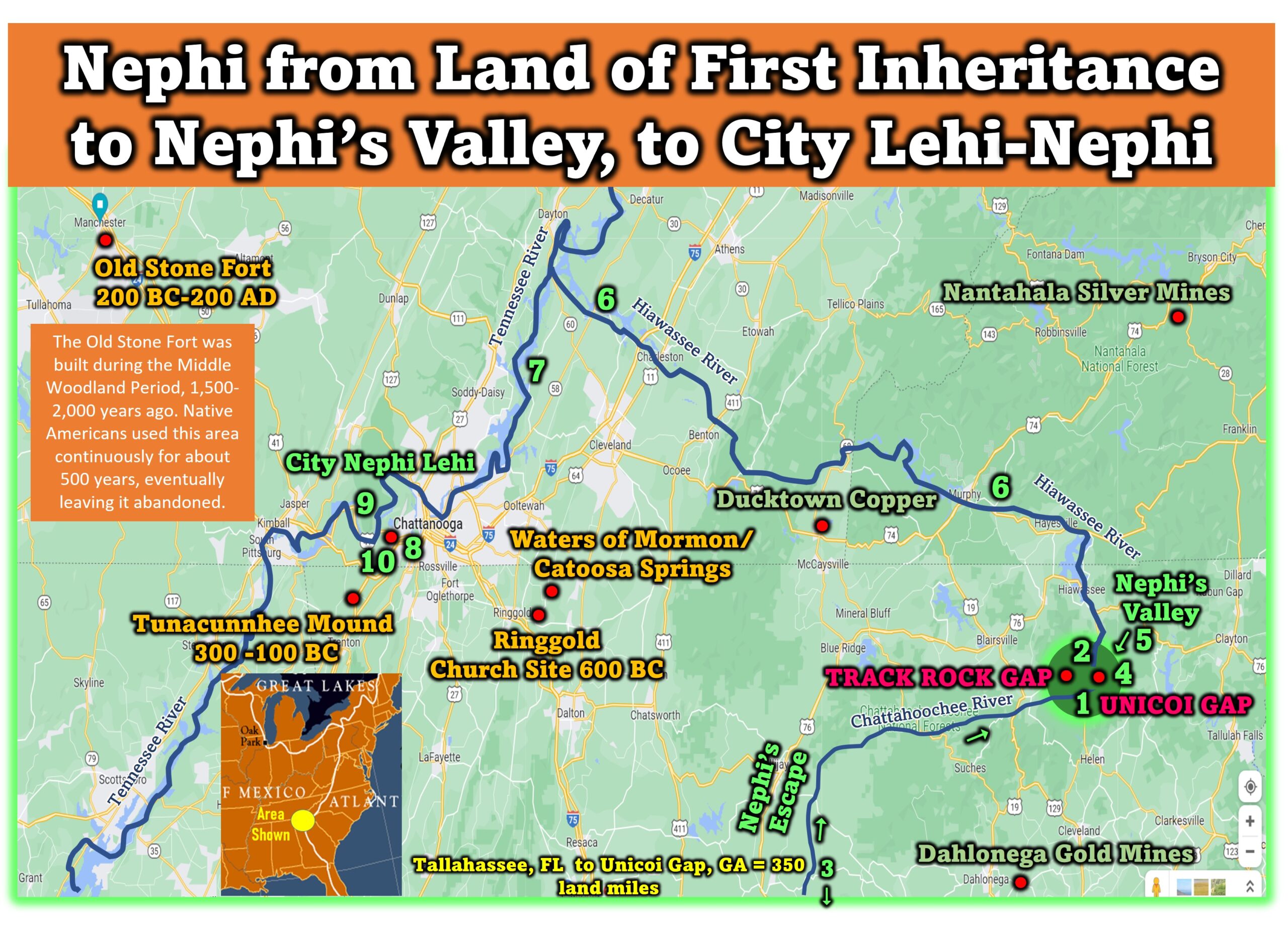
I will now discuss Track Rock Gap an archaeological site in northern Georgia. My friends Betty and Mike LaFontaine sent me personal pictures from their wonderful adventure at Track Rock Gap. They inspired me once again to do this blog about the importance of that area. I believe this is prime area where Nephi traveled to, in order to get away from Laman and Lemuel. From this Track rock Gap area they probably traveled north on the Hiawassee River into the city Lehi-Nephi or what I believe to be Chattanooga, TN., where Nephi lived and prospered building the first Nephite Temple.
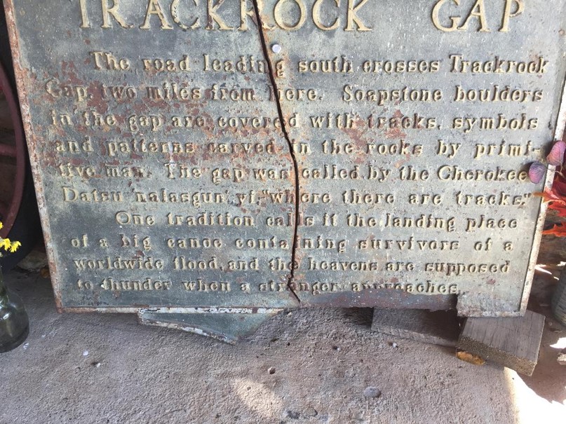
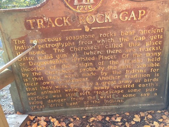
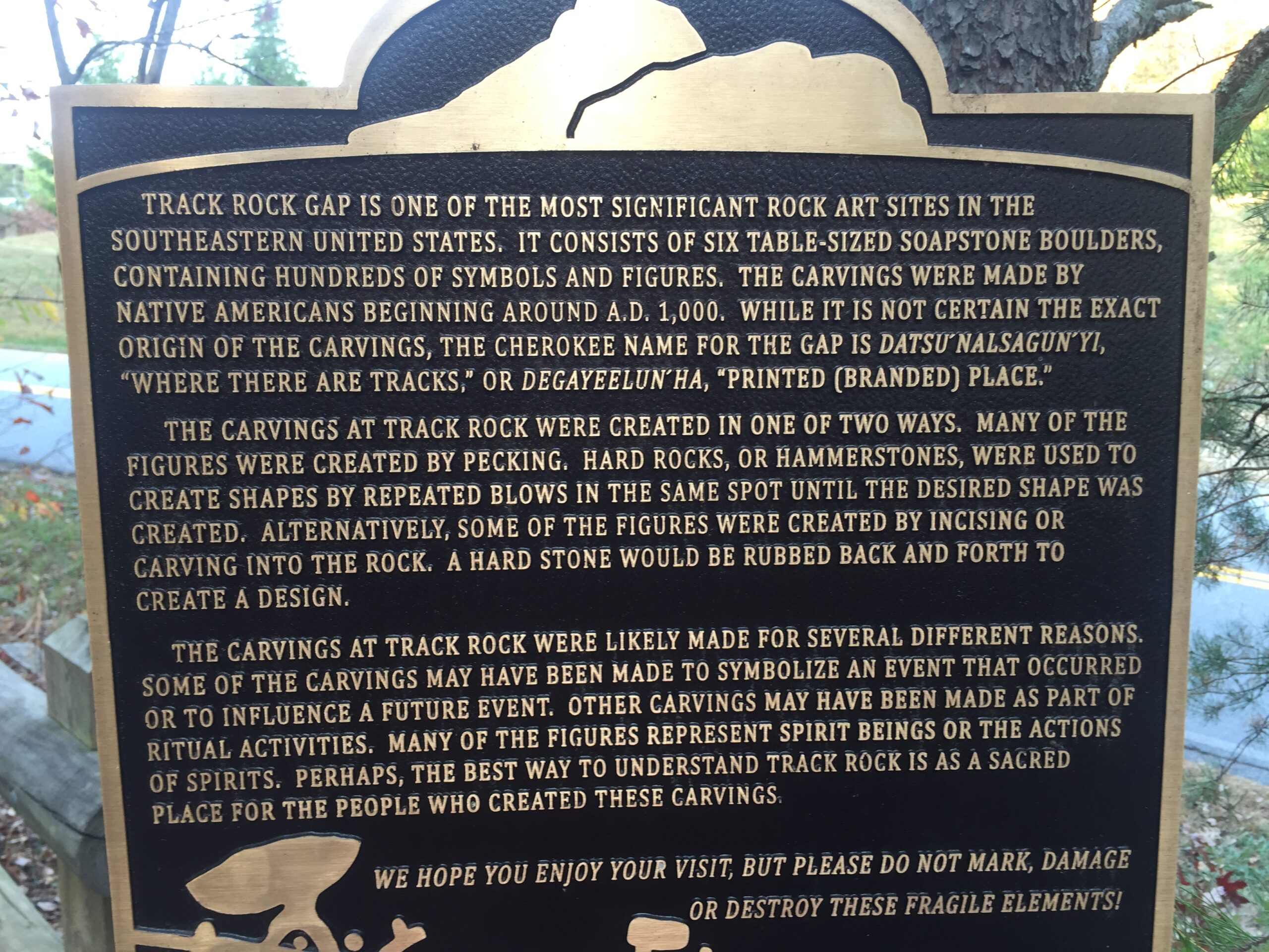
Track Rock Gap Origins The Georgia Historical Marker placed there in 1988 says:
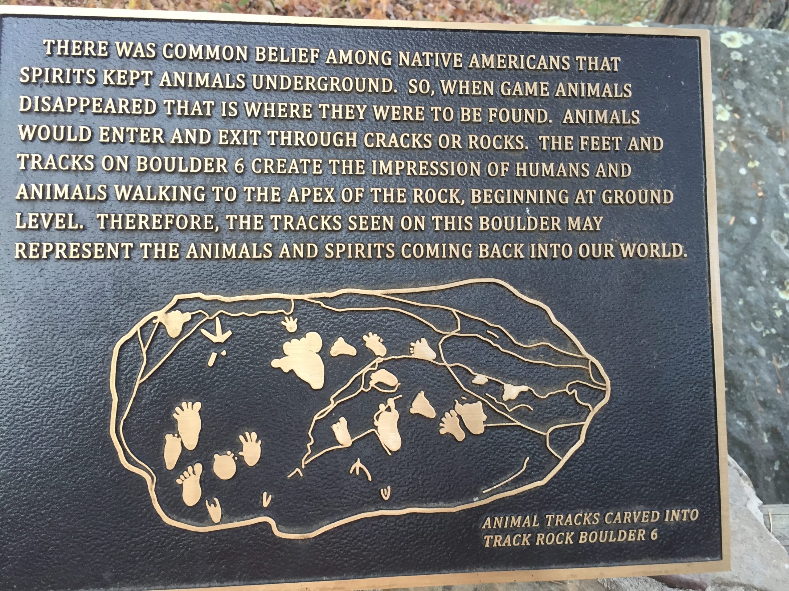
This area is one of the best-known of the petroglyph, or marked stone, sites in Georgia. The six table-sized soapstone boulders contain hundreds of symbols carved or pecked into their surface. Archaeologists have speculated dates for the figures from the Archaic Period (8,000 to 1,000 B.C.) to the Cherokee Indians who lived here until the 19th Century. No one knows the exact meaning of the symbols or glyphs which represent animals, birds, tracks and geometric figures. The earliest written account (1834) was by Dr. Matthew Stephenson, who was director of the U.S. Branch Mint in Dahlonega. One of the favorite stories about Track Rock Gap was recorded by ethnographer James Mooney who gathered Cherokee stories. The Cherokee called this site Datsu’nalasgun’ylu (where there are tracks) and Degayelun’ha (the printed or branded place). Cherokee stories include an explanation that hunters paused in the gap and amused themselves by carving the glyphs: the marks were made in a great hunt when the animals were driven through the gap, and that the tracks were made when the animals were leaving the great canoe after a flood almost destroyed the world and while the earth and rocks were soft.[1]
In 1867, conservationist John Muir traveled nearby and met a mountaineer who said, “It is called Track Gap … from the great number of tracks in the rocks – bird tracks, bar tracks, hoss tracks, men tracks, all in the solid rock as if it had been mud.”[2]
There is a gravel parking lot at Track Rock; the site is also accessible via the Arkaquah Trail. Track Rock Gap Archaeological Area is under consideration for listing on the National Register of Historic Places, reference number 76002336, but it is still pending.https://en.wikipedia.org/wiki/Track_Rock
What is the Track Rock Gap stone landscape?
Stone landscape sites, such as the one located near Track Rock Gap on the Chattahoochee National Forest in Union County, Georgia, occur throughout the region and are not unusual. Some mark important geographical locations while others have a ceremonial origin. In Georgia these were created by the Cherokee and Creek Indians and by their ancestors, while they were created by other Tribes in other states. American Indians consider these to be an important type of site that should be respected and protected. Archeologists do not understand everything about the function and use of these sites, but research is continuing. The Southern Region of the U.S. Forest Service is working with the United South and Eastern Tribes (USET) to study these sites so that we can better understand and protect stone landscape sites. https://www.fs.usda.gov/detailfull/conf/home/?cid=stelprdb5379176
Nephi’s Valley Unicoi Gap, GA
Some people believe Track Rock Gap was done by the Mayans. See Richard Thornton here: I believe the Mayans came up into the Missouri, Alabama and Georgia areas in about 900 AD and lived on top of where the Lamanites and Cherokee lived. The Mayans probably left some of their culture and probably did some engravings etc. However, The Mayans went back to Mesoamerica in about 1200 AD.
According to Wayne May and may of the Chiefs of Native Americans he met with, in Nauvoo a few years ago, they told Wayne these Mayans were called “the Snake People” by the Native Americans and the Mayans overpowered the simple hunter gatherer Lamanites and turned them into slaves. In fact these chiefs said the Mayans (Snake People) forced the Lamanites to build many of their mounds including the one called Cahokia near St Louis which is dated at 1000 AD.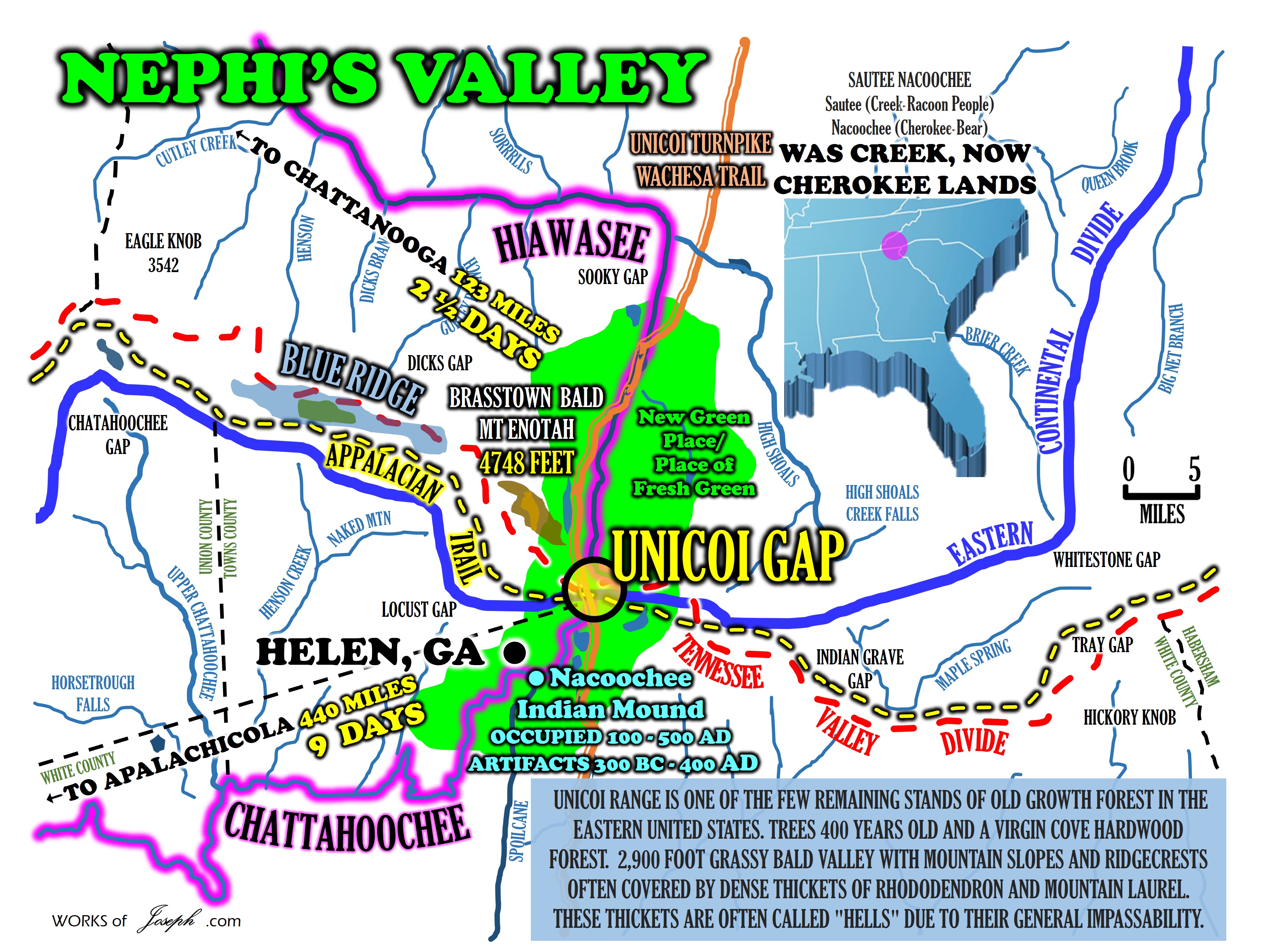
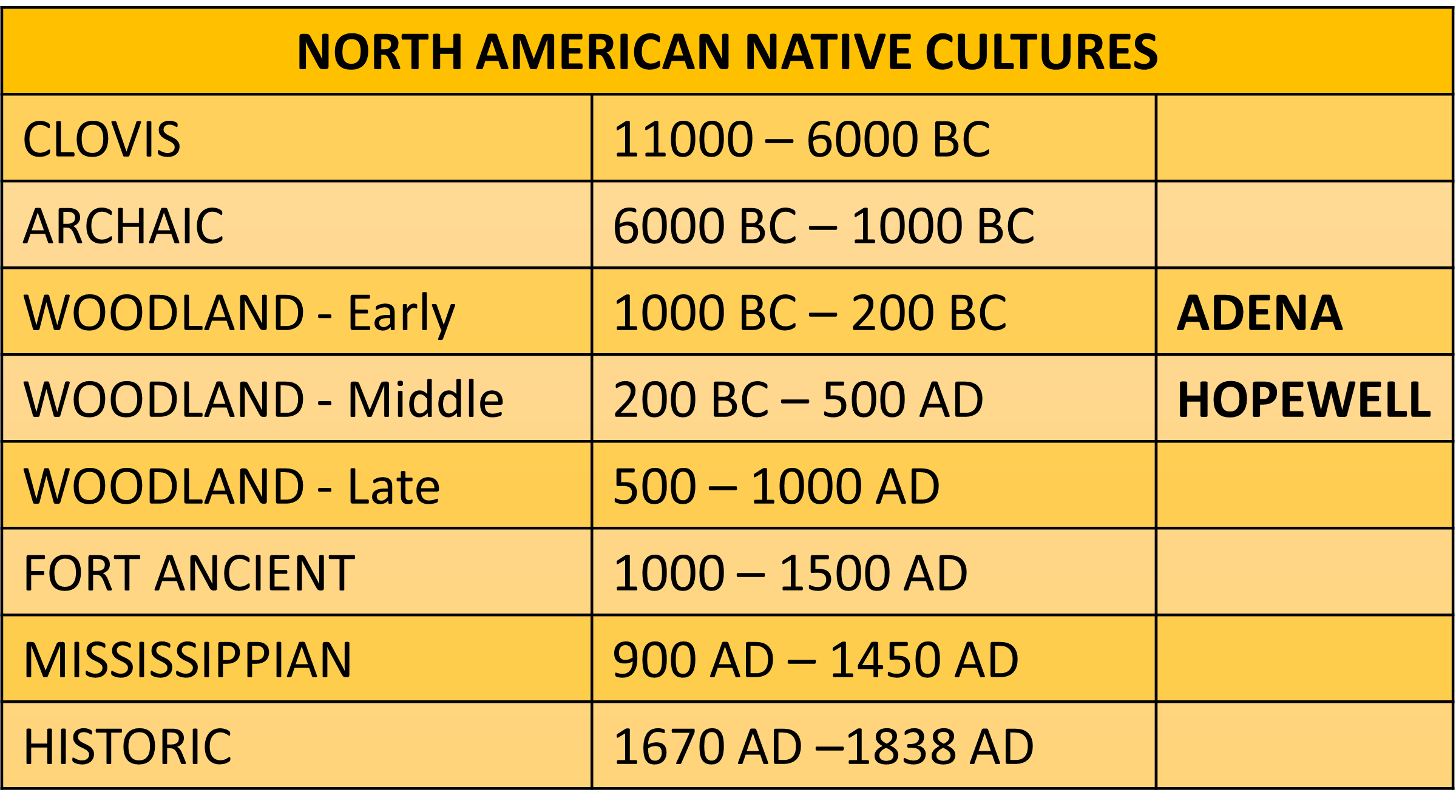
It seems the Adena began their building of mounds 1500 BC to 300 AD, and then the Hopewell 600 BC to 400 AD, built on top of those in the Heartland of North America, and then the Mayans or Mississippian Culture, 900 to 1400 AD built on top of the Hopewell. Many Native Americans that were never part of the Mayans were called the Fort Ancient culture 1000 AD to 1500 which was very different than the Mississippian culture, and the main Native Americans we hear about most today are from the Historical Period 1670 to 1866 AD or so.
It is obvious from the above timeline that the Native Americans (Nephites and Lamanites) mixed with all cultures from possible Hebrews through the Mulekites, or Asians through the Brother of Jared and his friends, or the Vikings of 1000 AD, or the Mayan of 900 AD. The “Blood of Lehi” is mixed all over North, Central, and South America today. Many prophets today mention in Temple dedication prayers the “Children of Lehi” as you can read more about here.
 Creek and Cherokee Tribes Also Debunk Mayan Myth
If you have any doubts as to the Native American origins of Track Rock Gap site and to Native American heritage that have been destroyed, this video shows the Muscogee Creek Nation and the Eastern Band of Cherokee Indians, in their own words, “debunking the Mayan myth,” and explaining clearly what the site and petroglyphs mean to their peoples, and why, horribly ironically, “it’s so important to protect it.”
But folks, this is a direct, and determined, attack on Native American heritage “not” on pre-Colombian Mexican heritage , as the internet might have you believe.
Top image: A completely painted over area on an ancient petroglyph stone in Georgia’s Trap Rock Gap: the work of stupid vandals with nothing better to do. Source: U.S. Forest Service – Chattahoochee-Oconee National Forests By Ashley Cowie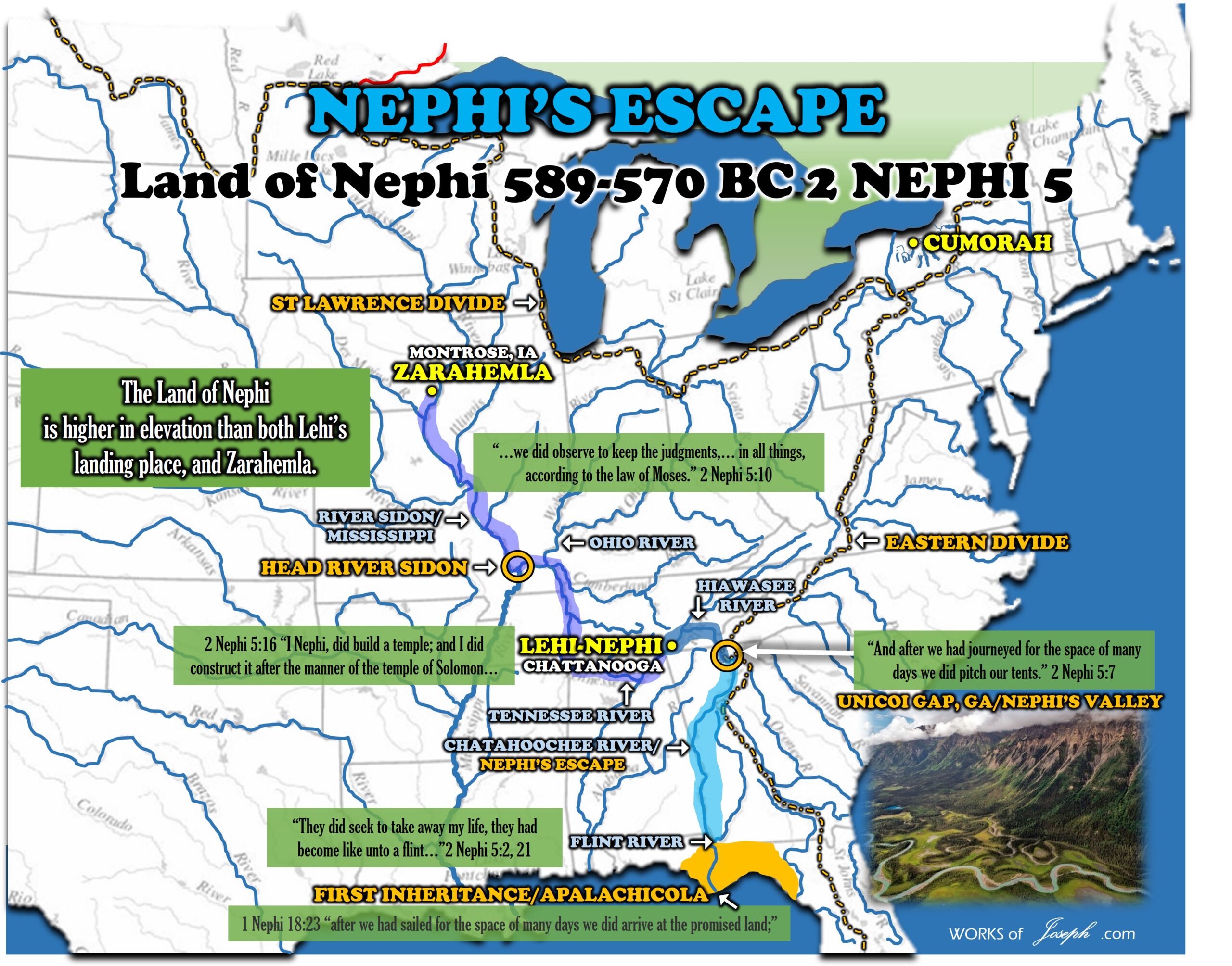
History Carved on a Rock
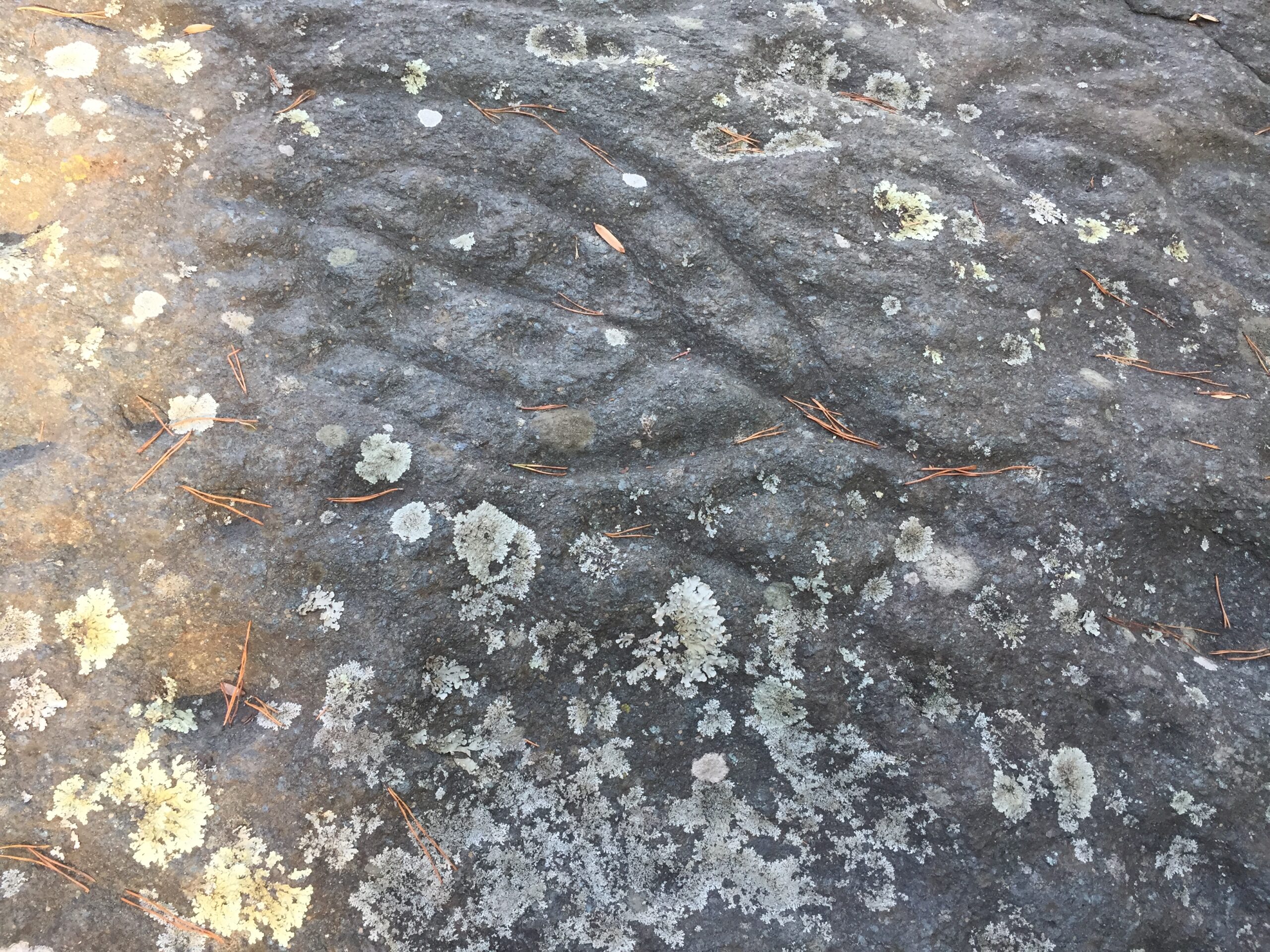
Track Rock Gap is one of the best-known of the petroglyph, or marked stone, sites in Georgia. The six table-sized soapstone boulders contain hundreds of symbols carved or pecked into their surface. Archaeologists have speculated dates for the figures from the Archaic Period (8,000 to 1,000 BC) to the Cherokee Indians who lived here until the 19th century. No one knows the exact meaning of the symbols or glyphs, which seem to represent animals, birds, tracks and geometric figures. The earliest written account was in 1834 by Dr. Matthew Stephenson, who was director of the U.S. Branch Mint in Dahlonega.
One of the favorite stories about Track Rock Gap was recorded by ethnographer James Mooney who gathered Cherokee stories. The Cherokee called this site Datsu`nalasgun`ylu (where there are tracks) and Degayelun`ha (the printed or branded place). Cherokee stories include an explanation that hunters paused in the gap and amused themselves by carving the glyphs: the marks were made in a great hunt when the animals were driven through the gap, and that the tracks were made when the animals were leaving the great canoe after a flood almost destroyed the world and while the earth and rocks were soft. Unlike other similar Native American sites, these petroglyphs are carved into huge soapstone boulders and not drawn or painted on the rocks.
Track Rock Archaeological Site
Legends and folklore, mysteries and myths, science and speculation can’t completely explain the ancient encrypted carvings on large boulders located at the Track Rock Archaeological Area.
The Track Rock Gap Archaeological Area is in the North Georgia’s Chattahoochee National Forest just below Brasstown Bald along Union County’s eastern border. This archaeological site lies in a low gap between two mountain ranges and is easily accessed along Trackrock Road just off US/76 East. The roadway travels right next to the archaeological site and Trackrock Trail.
Trackrock Road, which passes over the gap next to the site, is part of an ancient Native American trade route that traveled from north to south through the mountains. This site and trade route is estimated to have been in use since 1,000 AD; some speculate that the site and trade route are several thousands years old.
![]() There are six major boulders at the site covered in encrypted carvings along with several other smaller stones scattered about the site that appear to have some type of carvings. These primitive carvings depict ancient symbols of human and animal forms, plus what might be described as spirit beings. These carving were created at different times and not all at once. Each set of carvings appears to tell a story, or possibly a type of ritual.
There are six major boulders at the site covered in encrypted carvings along with several other smaller stones scattered about the site that appear to have some type of carvings. These primitive carvings depict ancient symbols of human and animal forms, plus what might be described as spirit beings. These carving were created at different times and not all at once. Each set of carvings appears to tell a story, or possibly a type of ritual.
Whatever the mysteries at Track Rock Archaeological Area are, is all up to speculation since the stones speak a language that archaeologists as well as the native Cherokee haven’t been able to decipher, as of yet. Symbols may coincide with native legends yet their meanings are too uncertain. The Blue Ridge Highlander believes each visitor to the site can decide for themselves as to their nature and purpose.
Newly added to the site is an interpretive area alongside the main boulders. What’s been removed from the site are the old protective grated cages that covered some of the larger boulders, often visually obstructing the carvings though providing adequate protection from earlier vandalism and theft.

Appalachian Trail Access Points in Union County
The Appalachian National Scenic Trail, (white blazed) also known as the AT, is over 2,100-miles long, mostly following the Blue Ridge and Appalachian Mountains’ backbone from Springer Mountain in North Georgia to Mount Katahdin in Maine. North Georgia’s Chattahoochee National Forest portion of the trail extends over 75-miles, traversing some of the most exceptional regions and mountain vistas in its entire 2,100-miles.
Along the southern regions of the Blue Ridge Mountain Range in Union County, the trail traverses three high mountain gaps. These gap locations are direct access points to the AT and are reached by paved roadways. Other access trails that intersect the Appalachian Trail are also listed below and are GPS’d at large recreation areas or notable points of interest. The entire Appalachian Trail should be regarded as moderate to strenuous in difficulty.