
“And now it came to pass that Moroni did not stop making preparations for war, or to defend his people against the Lamanites; for he caused that his armies should commence in the commencement of the twentieth year of the reign of the judges, that they should commence in digging up heaps of earth round about all the cities, throughout all the land which was possessed by the Nephites.” Alma 50:1

Moroni’s Fortifications
My good friend and artist Clark Kelley Price, painted this beautiful rendition above of Moroni fortifying the Nephite Lands as described in Alma 50. Clark read this chapter over and over trying to make this fortification as realistic as possible as it would have been in the Untied States of America. https://clarkkelleyprice.com/
I place this fortification somewhere near Pittsburgh, PA or Moundsville, WV as those locations would make a good fort along the Ohio/Allegheny Rivers to protect the Nephites with the rivers at their back and the East Wilderness in front as they began pushing the Lamanites east and south. (Alma 50:9) You will understand better as you read this blog.
Alma Chapter 50 I believe is one of the best sources for geography of the Book of Mormon in North America. I love creating maps as I read the text. Everything comes alive for me and I hope it does for you as well. See on maps below as this fortification could represent Pittsburgh, PA or Moundsville, WV
Read Alma 50: verse 1-6 below to understand Clark’s painting better.
 ALMA CHAPTER 50
Moroni fortifies the lands of the Nephites—They build many new cities—Wars and destructions befell the Nephites in the days of their wickedness and abominations—Morianton and his dissenters are defeated by Teancum—Nephihah dies, and his son Pahoran fills the judgment seat. About 72–67 B.C.
1 And now it came to pass that Moroni did not stop making preparations for war, or to defend his people against the Lamanites; for he caused that his armies should commence in the commencement of the twentieth year of the reign of the judges, that they should commence in digging up heaps of earth round about all the cities, throughout all the land which was possessed by the Nephites.
2 And upon the top of these ridges of earth he caused that there should be timbers, yea, works of timbers built up to the height of a man, round about the cities.
3 And he caused that upon those works of timbers there should be a frame of pickets built upon the timbers round about; and they were strong and high.
4 And he caused towers to be erected that overlooked those works of pickets, and he caused places of security to be built upon those towers, that the stones and the arrows of the Lamanites could not hurt them.
5 And they were prepared that they could cast stones from the top thereof, according to their pleasure and their strength, and slay him who should attempt to approach near the walls of the city.
6 Thus Moroni did prepare strongholds against the coming of their enemies, round about every city in all the land.
If Moroni prepared strongholds in every city in all the land, can you imagine how many that would be? Not 10 or even 100, I would guess hundreds of strongholds. Here is a good quote concerning this number of fortifications.
Archaeological Evidence

“ON THE SOUTH SIDE OF LAKE ERIE, THERE IS A SERIES OF OLD FORTIFICATIONS, RUNNING FROM THE CATTARAUGUS CREEK TO THE PENNSYLVANIA LINE, A DISTANCE OF FIFTY MILES; some are two, three, and four miles apart, and some within half a mile. Some contain five acres… Still further south, there is said to be another chain of forts running parallel with the former, and about the same distance from them as those are from the lake… Whether the nations, which possessed our western country before the Iroquois, had erected those fortifications to protect them against their invaders, or whether they were made by anterior inhabitants, are mysteries which cannot be penetrated by human sagacity; nor can I pretend to decide whether the Eries or their predecessors raised the works of defense in their territory; but I am persuaded that enough has been said to demonstrate the existence of a vast population, settled in towns, defended by forts, cultivating agriculture, and more advanced in civilization than the nations which have inhabited the same countries since the European discovery.” Clinton, De Witt. A Memoir On The Antiquities Of The Western Parts Of The State Of New-York Complete Book at the end of this blog; (Note: Map and comment Below: Remember not even the Native Americans know who built these fortifications, meaning a much earlier people than the Native Americans (perhaps the Hopewell or Nephite people) built these strongholds.
“It appears to me that there are two distinct eras in our antiquities; one applicable to the remains of old fortifications and settlements which existed anterior to European intercourse…. The old fortifications were erected previous to European inter course. The Indians are ignorant by whom they were made; and in the wars which took place in this country it is probable that they were occupied as strongholds by the belligerents; and it is likely that the ruins of European works of a different construction may be found in the same way that Roman and British fortifications are to be seen in the vicinity of each other in Great Britain. It is remarkable that our ancient forts resemble the old British and Danish.” Clinton, De Witt. A Memoir On The Antiquities Of The Western Parts Of The State Of New-York
Chief Joseph
“When Chief Joseph, a renowned Nez Perce leader, surrendered to Europeans in 1877, he gave a special gift to General Nelson Appleton Miles, wrote Vine Deloria, Jr. in his book Red Earth white Lies. The gift received by the general was a pendant that turned out to be an ancient Mesopotamian cuneiform tablet. According to Benjamin Daniali of AssyriaTimes.com, the tablet was translated by Robert Biggs, professor of Assyriology at the Oriental Institute of the University of Chicago. Professor Biggs found that it was a sales receipt for a lamb dating back to 2042 B.C.
Mary Gindling of Helium’s History Mysteries wrote, “The chief said that the tablet had been passed down in his family for many generations, and that they had inherited it from their white ancestors. Chief Joseph said that white men had come among his ancestors long ago.” ICT News, covers the latest stories and issues affecting Native American communities across the continent.
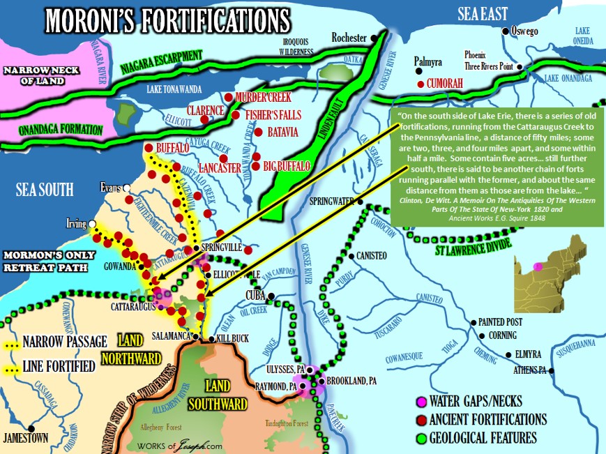
The yellow lines in the map above represent a day for a Nephite, and a day and a half for a Nephite, and the Narrow Passage spoken of in Mormon 2:29. This is the “SERIES OF OLD FORTIFICATIONS, RUNNING FROM THE CATTARAUGUS CREEK TO THE PENNSYLVANIA LINE, A DISTANCE OF FIFTY MILES” [Red dots above], spoken of in this quote. This 44 miles from the Land Northward as shown on the map above at Irving, NY to the Land Southward to Salamanca, NY needed to be protected. Also, this 66 miles from the Land Northward at Buffalo NY to the beginning of the Land Southward at Kill Buck, NY is the proposed day and a half for a Nephite. See map below.
 (See Moroni’s America page 241 quoted below).
“What is Mormon’s frame of reference here? (Mormon 2:29) He is writing from his own homeland, where he grew up. It is the same perspective he had when, as a boy, his father took him “into the land southward, even to the land of Zarahemla” (Mormon 1:6). The Lamanites received all the land southward.
This is the only mention in the text of a “narrow passage.” It is not a neck or even a pass; it may not be a natural feature at all. A passage is a “road; way; avenue; a place where men or things may pass or be conveyed.”
As part of a treaty, it appears to be an agreed-upon route or way—a corridor—through which access between the two lands would be permitted.
The narrow passage specified in this treaty reminds me of the narrow passages, also established by treaty, between West Germany and Berlin during the cold war. One could travel within these passages, but veering outside could mean arrest and imprisonment.
In terms of real world geography, there are numerous valleys, long narrow rises and hills, and other features in western New York that could have served as the narrow passage defined by this treaty. Presumably this narrow passage would give access to the river system that led into the land southward—the very river system Mormon’s father took him on when he was eleven years old.” Moroni’s America page 241-242.
“Passage,” Webster’s 1828 Dictionary, http://bit.ly/Moroni113.
This quote from De Witt Clinton again here saying, “ON THE SOUTH SIDE OF LAKE ERIE, THERE IS A SERIES OF OLD FORTIFICATIONS, RUNNING FROM THE CATTARAUGUS CREEK TO THE PENNSYLVANIA LINE, A DISTANCE OF FIFTY MILES;” I use this quote often which I believe is describing the Narrow Passage in the Book of Mormon in Mormon 2:29 which says, “And the Lamanites did give unto us the land northward, yea, even to the narrow passage which led into the land southward. And we did give unto the Lamanites all the land southward.”
MORONI FORTIFIES THE LANDS OF THE NEPHITES – Alma 50:1-15 About 72–67 B.C.
1 “And now it came to pass that Moroni did not stop making preparations for war, or to defend his people against the Lamanites; for he caused that his armies should commence in the commencement of the twentieth year of the reign of the judges, that they should commence in digging up heaps of earth round about all the cities, throughout all the land which was possessed by the Nephites.
2 And upon the top of these ridges of earth he caused that there should be timbers, yea, works of timbers built up to the height of a man, round about the cities.
3 And he caused that upon those works of timbers there should be a frame of pickets built upon the timbers round about; and they were strong and high.
4 And he caused towers to be erected that overlooked those works of pickets, and he caused places of security to be built upon those towers, that the stones and the arrows of the Lamanites could not hurt them.
5 And they were prepared that they could cast stones from the top thereof, according to their pleasure and their strength, and slay him who should attempt to approach near the walls of the city.
6 Thus Moroni did prepare strongholds against the coming of their enemies, round about every city in all the land.
7 And it came to pass that Moroni caused that his armies should go forth into the east wilderness; yea, and they went forth and drove all the Lamanites who were in the east wilderness [Map Below] into their own lands, which were south of the land of Zarahemla.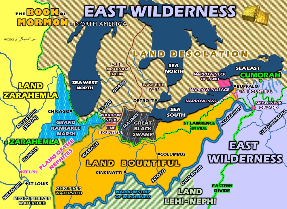
8 And the land of Nephi did run in a straight course [Map below with Latitudes] from the east sea to the west.
9 And it came to pass that when Moroni had driven all the Lamanites out of the east wilderness, which was north of the lands of their own possessions, he caused that the inhabitants who were in the land of Zarahemla and in the land roundabout should go forth into the east wilderness, even to the borders by the seashore, and possess the land.
10 And he also placed armies on the south, in the borders of their possessions, and caused them to erect fortifications that they might secure their armies and their people from the hands of their enemies.
11 And thus he cut off all the strongholds of the Lamanites in the east wilderness, yea, and also on the west, fortifying the line between the Nephites and the Lamanites, between the land of Zarahemla and the land of Nephi, from the west sea, running by the head of the river Sidon—the Nephites possessing all the land northward, yea, even all the land which was northward of the land Bountiful, according to their pleasure.
12 Thus Moroni, with his armies, which did increase daily because of the assurance of protection which his works did bring forth unto them, did seek to cut off the strength and the power of the Lamanites from off the lands of their possessions, that they should have no power upon the lands of their possession.
13 And it came to pass that the Nephites began the foundation of a city, and they called the name of the city Moroni; and it was by the east sea; and it was on the south by the line of the possessions of the Lamanites.
14 And they also began a foundation for a city between the city of Moroni and the city of Aaron, joining the borders of Aaron and Moroni; and they called the name of the city, or the land, Nephihah.
15 And they also began in that same year to build many cities on the north, one in a particular manner which they called Lehi, which was in the north by the borders of the seashore.”
In the map above there are some very interesting things. In Alma 50 the main border between the Lamanites and the Nephites is the light blue rivers above, the Ohio and the Allegheny. In verse 8 is says, “And the land of Nephi did run in a straight course from the east sea to the west.” Clearly the East Sea is represented by the Atlantic Ocean. The words “to the west” could represent and border or barrier along the Ohio River.
Notice above that the straight course would imply a common latitude and there are many cities on the East Sea that match up with cities on the Ohio River. In my opinion the most likely straight course would be from the Head of the river Sidon (confluence of the Ohio and Mississippi rivers) with the city of Norfolk, VA which is a strait course both being about 37 degrees latitude.
As you read in verse 13 above it says, “And it came to pass that the Nephites began the foundation of a city, and they called the name of the city Moroni; and it was by the east sea; and it was on the south by the line of the possessions of the Lamanites. Where is the line of possessions of the Lamanites? At that 37 degree latitude or the 38 degrees of Washington DC and Huntington WV or Moroni could be from Philadelphia to Moundsville at nearly 40 degrees latitude.
I have reasoned that wouldn’t it be fairly cool if the ancient city of Moroni was either Philadelphia, Baltimore, Washington DC or Norfolk? I have done some wonderful research around the Washington DC area to see what signs of the Hopewell people we could find. Amazingly there are many mounds and sites that date to the time of the verses in Alma 50 which would be around 73 BC. See map below of the sites in DC area.

Also in verse 14 of Alma 50 it says, “And they also began a foundation for a city between the city of Moroni and the city of Aaron, joining the borders of Aaron and Moroni; and they called the name of the city, or the land, Nephihah.” If the city Moroni that “was by the east sea; and it was on the south by the line of the possessions of the Lamanites” (verse 13), if we find that line of the Lamanite possessions which is the same as the straight course line, we could find the ancient city of Moroni and the Land of Nephihah which would be north of Moroni.
I have overloaded you with maps in this blog. Unless you are willing to follow the rivers, artifacts, geology, terrain, text, and all evidence, it will be difficult for you to find secondary evidence for the Book of Mormon. Each map created here has a specific purpose and I challenge you to read for yourself the text of the Book of Mormon and I believe some of this geography will begin to make sense to you. Please don’t get caught up in the maps however. Read by the Spirit and the Lord will guide you in finding truth of whatever you seek, if it be the Lord’s will and your righteous desire.
Below is pages 131-142 of On the Antiquities of the Western parts of the State of New York
A MEMOIR by the Honourable Samuel L. Mitchill
On the Antiquities of the Western parts of the State of New York, addressed to the Honourable Samuel L. Mitchill, a Vice-President of the Literary and Philosophical Society of New York, Professor of Natural History in the University of the State, etc., etc. Page 131-142
“As the progress of cultivation extinguishes the remains of Antiquities mentioned in this Memoir, the view of the writer, in publishing it, is to awaken enquiry to a subject of great importance, before the means of investigation are entirely lost.
…The town of Pompey, in the county of Onondaga, is the highest ground of that country,* and divides the waters which flow into the bay of Chesapeake and the Gulph of St. Lawrence. The most elevated parts of the town exhibit the remains of ancient settlements, and in various other parts of it, the vestiges of a numerous population appear. About two miles south from Manlius Square, and in the town of Pompey, I examined the remains of a large town, which were obviously indicated by large spots of black mould in regular intervals of a few paces distant,! in which I ob served bones of animals, ashes, carbonized beans or grains of Indian corn, denoting the residence of human beings. This town must have extended at least half a mile from east to west, and threequarters of a mile from north to south. This extent I could de termine \vith considerable accuracy from my own view, but I was assured by a gentleman of veracity that its length from East to west was one mile. A town covering upwards of five hundred acres must have contained a population greatly transcending all our ideas of credibility. A mile to the east of the settlement there is a burying-ground containing three or four acres, and close to the west end there is another. This town was on elevated ground, about twelve miles distant from the Salt Springs on Onondaga, and was well calculated for defense. On the east side there is a perpendicular descent of one hundred feet into a deep ravine, through which a fine stream flows, and on the north side a similar one. There are three old forts situate distant about eight miles from each other, and forming a triangle which encloses the town; one a mile south of the present village of Jamesville, and the other north-east and south-east in Pompey ; and they were, in all probability, erected to cover the town and to protect the inhabitants against the attacks of an enemy. All these forts are of a circular or elliptical form; there are bones scattered all over the ground; an ash tree growing on it was cut down, and the con centric circles showed it to be ninety-three years old. On a heap of mouldered ashes, composing the site of a large house, I saw a white pine tree, eight and a half feet in circumference and at least one hundred and thirty years old. On the line of the north side the town was probably stormed.
There are graves on each side close to the precipice; sometimes five or six persons were thrown promiscuously into the same grave. If the invaders had been repulsed, the inhabitants would have interred the killed in the usual places; but from the circumstance of there being graves near the ravine and in the village, I am induced to believe that the town was taken. On the south side of this ravine a gun-barrel, several bullets, a piece of lead, and a skull perforated by a bullet, were dis covered. Indeed, gun-barrels, axes, hoes and swords were found all over these grounds, and I procured the following articles, which I now transmit to the Society to be deposited in their collection: two mutilated gun-barrels, two axes, a hoe, a bell without a clapper, a piece of a large bell, a finger-ring, a sword blade, pieces of bay onets, gunlocks and earthenware, a pipe, door-latch, beads and several other small things. These demonstrate European inter course, and from the attempts which were evidently made to ren der the gun-barrels useless by filing them, there can be little doubt but that the Europeans who had settled here were defeated and driven from the country by the Indians.
Near the remains of this town I observed a large forest, which was in former times cleared and under cultivation; and I drew this inference from the following circumstances: There were no hillocks or small mounds which are always the result of uprooted trees; no uprooted or decaying trees or stumps, no underwood, and the trees were generally fifty or sixty years old. Many, very many, years must elapse before a cultivated country is covered with wood. The seeds must be slowly conveyed by winds and birds. The town of Pompey abounds with forests of a similar character; some are four miles long and two wide, and it contains a great number of ancient places of interment. I have heard them estimated at eighty. If the present white population of that county were entirely swept away, perhaps in the revolution of ages similar appearances would exist.
It appears to me that there are two distinct eras in our antiquities; one applicable to the remains of old fortifications and settlements which existed anterior to European intercourse, and the other referring to European establishments and operations; and as the whites as well as the Indians would frequently resort to the former for protection, habitation or hunting, they must necessarily contain many articles of European manufacture, and thereby great confusion has resulted by blending together distant eras greatly remote in point of time. The French had, undoubtedly large establishments in the territory of the Six Nations. A quarto volume in Latin, written by Francis Creuxines, a Jesuit, was published at Paris in 1664, and is entitled Historicae Canadensis sen Novae Franciae Libri deceum ad annum usque Christi, MDCLVI. 134
…The traditions of the Indians agree in some measure with the French relations. They represent that their forefathers has several bloody battles with the French and finally compelled them to abandon the country; that the French, after being driven to their last fortress, capitulated and agreed to depart on being furnished with provisions; that the Indians filled their bags with ashes, covered with corn, and that the greater part of the French in consequence fell victims to famine at a place called by them anse de famine and by us, Hungry Hill. There is a hill in Pompey which the Indians will not visit, and which they call Bloody Hill.[See map above] It is surprising that no old Indian weapons, such as stone knives, axes and arrowheads, are found in this country*. It appears that they were superseded by French substitutes of iron.
The old fortifications were erected previous to European inter course. The Indians are ignorant by whom they were made; and in the wars which took place in this country it is probable that they were occupied as strongholds by the belligerents; and it is likely that the ruins of European works of a different construction may be found in the same way that Roman and British fortifications are to be seen in the vicinity of each other in Great Britain. It is remarkable that our ancient forts resemble the old British and Danish. Pennant, in his Tour in Scotland, says: “On the hill, near a certain spot, is a circular British entrenchment, and I was told of others of a square form at a few miles’ distance, I suppose Roman” — and in his Tour through Wales he describes “a strong British post on the summit of a hill in Wales, of a circular form, with a great foss(e) and dike and a small artificial mount within the precinct.” How exactly does this correspond with our old forts! The Danes as well as the nations which erected our fortifications, were in all probability of Scythian origin. According to Pliny, the name of Scythian was common to all the nations living in the north of Asia and Europe.
In the town of Camillus, in the same county of Onondaga, about four miles from the Seneca River, thirty miles from Lake Ontario, and eighteen from Salina, there are two ancient forts, on the land of Judge Munro, who has been settled there about nine teen years. One is on a very high hill, and its area covers about three acres. It had one eastern gate, and in the west there was another communicating with a spring about ten rods from the fort; its shape elliptical. The ditch was deep and the eastern wall ten feet high. In the centre was a large limestone of an irregular shape, which could be raised by two men; the bottom was flat and three feet long. It contained, in the opinion of Judge Munro, unknown characters plainly figured on the stone to the extent of eighteen inches in length and three inches in breadth. When I visited this place the stone was not to be seen, and my enquiries to find it were unsuccessful. I saw the stump of a black oak on the wall, one hundred years old; and about nineteen years ago there were indicia of two preceding growths. The second fort is almost half a mile distant, on lower ground, constructed like the other, and is about half as large. Near the large fort there are the marks of an old road, now covered by trees. I also saw in several places in this town, on high ground, considerable ridges stretching from the top to the bottom of the hills and the gullies between of no great width. This phenomenon occurs in very ancient settlements where the soil is loamy and the hills steep, and is occasioned by crevices produced and gradually enlarged by torrents. In a forest state this effect cannot result, and this evinces that those grounds were cleared in antient times. When settled by us they exhibited the same appearance as now, except being covered by wood; and as stumps are now to be seen in the gullies, the ridges and intervening small ravines could not have been made by the last clearing. The first settlers observed shells of testaceous animals accumulated in great masses in different places, and numerous fragments of pottery. Judge Munro found, in digging the cellar of his house, several pieces of brick. In various places there were large spots of deep black mould, demonstrating the former existence of buildings and erections of different kinds; and Judge Munro, seeing the appearance of a well, viz: a hole ten feet deep and the earth considerably caved in, he dug three and a half feet deep and came to a parcel of flints, below which he found a great quantity of human bones, which pulverized on exposure to the air. This is strong evidence of the destruction of an ancient settlement. The disposal of the dead was unquestionably made by an invading enemy.
I also observed on Boughton’s Hill, in Ontario county, where a bloody battle is said to have been fought, black spots of mould at irregular intervals, and yellow clay between. The most easterly fortification yet discovered in this region is about eighteen miles east of Manlius Square, with the exception of the one in Oxford, Chenango County, hereafter mentioned. To the north they have been discovered, as far as Sandy Creek, about fourteen miles from Sacket’s Harbor; near that place there is one that covers fifty acres and that contains numerous fragments of pottery. To the west there are great numbers. There is a large one in the town of Onondaga, one in Scipio, two near Auburn, three near Canandaigua, and several between Seneca and Cayuga Lakes, there being three within a few miles of each other. The fort before referred to as being in Oxford, is on the east bank of the Chenango River, in the centre of the present village, which is on both sides of the river. There is a piece of land containing between two and three acres, which is about thirty feet higher than the adjoining flat land around it. This rise of land lies- along the river bank about fifty rods, and at the southwesterly end this fort was situated. It contained about three roods of ground, and on the river the line was nearly straight and the bank almost perpendicular.
The figure was nearly like this:[left]
At the places north and south, marked for gates, there were two spaces of about ten feet each where the ground has not been broken, which were undoubtedly the entrances or gateways by which the people of the fort went out and in, and particularly for water. The curve, except the gateways, was a ditch regularly dug; and although the ground on which the fort was situated was, at the first white settlement, as heavily timbered as any other part of the forest, yet the lines of the work could be distinctly traced among the trees, and the distance from the bottom of the ditch to the top of the embankment, generally about four feet.
The antiquity of this fortification is more particularly evident from the following fact: There was one large pine tree or rather dead trunk, fifty or sixty feet high, which being cut, one hundred and ninety -five circles of the wood could be easily distinguished; and many more could not be counted, as the sap wood of the tree was principally gone. Probably this tree was three or four hundred years old; certainly more than two hundred. It might have stood one hundred years after it had completed its growth, and even longer. It is also uncertain how long a time elapsed from the excavation of the ditch to the commencement of the growth of this tree. That it was not there when the earth was thrown up is certain; for it stood on the top of the bank, and its roots had shaped themselves to the ditch, running quite under the bottom of it; then rising on the other side near the surface of the earth, and then pursuing a horizontal direction. Probably this work was picketed in, but no remains of any wooden work have been discovered. The situation was very eligible, being healthy, commanding a beautiful prospect up and down the river, and there being no highland within such a distance that the garrison could be annoyed. No vestiges of any implements or utensils have been found, except some pieces of coarse pottery resembling stoneware, and roughly ornamented. The Indians have a tradition that the family of the Antones*, which is supposed to belong to the Tuscarora nation, are the seventh generation from the inhabitants of this fort; but of its history they know nothing. There is also a place at Norwich, in the same county, on a high bank of the river, called the castle where the Indians lived at the period of our settling the country, and some vestiges of a fortification appear there, but it is in all probability of a much more modern date than the one at Oxford.
*[Evidence of a Native American tribe called the Antones, who belonged to the Tuscarora Nation, may have been the builders of a mound on 2 1/2 acres, called Fort Hill in Oxford. The remains were noticed when Oxford was first settled in 1788, and is one of the oldest fortifications in the east, dating back to before the discovery of this country by the Europeans. The strategic location of the hill provided an unobstructed view up and down the river. The Fort area was semi-circular, about 30′ high and enclosed about 3/4 acre of birch and maple trees. An old Oneida oral tradition told of a terrible enemy chief called “Thick Neck” of the Antone tribe, which dated back seven generations to Fort Hill. (Documented in the 1906 “Annals of Oxford, NY”, by H.J. Galpin.) Thick Neck had fought with the Oneidas, but finally they defeated him by Lake Warn (then called Warn’s Pond). After his death, Thick Neck’s leaderless tribe joined with the Oneidas.
Human bones, ancient earthen cooking utensils and other relics were found when excavations were made at Fort Hill. In October, 1897, while workmen were engaged in trenching the village for the water works, they uncovered parts of two skeletons in the road near the crosswalk west of the Congregational church known today as the United Church of Oxford]. http://www.oxfordny.com/about/yesterday/forthill.php
Antiquities of the Western parts of the State of New York continues saying, “In the town of Ridgeway, in Genesee County, there have been discovered several ancient fortifications and burial places. About six miles from the Ridge road, and south of the great slope or mountain ridge, an old burying ground has been discovered within two or three months, in which are deposited bones of an unusual length and size. Over this ground lay the trunk of a chestnut tree, apparently four feet through at the stump. The top and limbs of this tree had entirely mouldered away by age. The bones lay across each other in a promiscuous manner; from which circumstance and the appearance of a for, in the neighbourhood, it is supposed that they were deposited there by their conquerors; and from the fort being situated in a swamp, it is believed it was the last resort of the vanquished, and probably the swamp was under water at the time.
There are extensive clearings in the Indian reservation at Buffalo, of which the Senecas can give no account. [Plausible truth about the Hopewell or Nephites before the Seneca]. Their principal settlements were at a great distance to the east, until the sale of the greater part of their country since the conclusion of the Revolutionary War.

On the south side of Lake Erie [From Irving to Salamanca, NY above] there is a series of old fortifications running from the Cattaraugus Creek [apx. 44 miles or a Day for a Nephite to go from the land northward to the land southward] to the Pennsylvania line, a distance of fifty miles. Some are two, three and four miles apart, and some within half a mile. Some contain five acres. The walls or breastworks [are] of earth; and they are generally on ground where there are appearances of creeks having once emptied into the lakes ; or where there was once a bay ; so that it is inferred that these works were once on the margin of Lake Erie, which has now retreated from two to five miles northerly. Still further south, there is said to be another chain of forts running parallel with the former, [Blue line in map above or apx 66 miles for a Day and a Half for a Nephite to get from the land northward to the land southward] and about the same distance from them as those are from the lake. The country here exhibits two different tables or sections of bottom, intervale or alluvial land; the one nearest the lake being the lower, and if I may so denominate it, the secondary table land; the primary or more elevated table land is bounded on the south by hills and valleys where Nature exhibits her usual aspects.
The primary alluvial land was formed from the first retreat or recession of the lake, and then, it is supposed, the most southern line of fortifications was erected. In process of time the lake receded further to the north, leaving another section of table land, one which the other tier of works was made. The soil on the two flats is very different: the inferior being adapted for grass, and the superior for grain ; and the timber varies in a correspondent (sic) manner. On the south side of Lake Ontario there are also two* alluvial formations; the most recent is north of the ridge road; no forts have been discovered on it. Whether there be any on the primary table land I have not learnt; south of the mountain ridge many have been observed. *In the original “too.”
In the geology of our country it is important to remark that the two alluvial formations before mentioned are, generally speak ing, characteristic of all the lands bordering on the western waters ; while on the eastern waters there is but one alluvial tract, with some few exceptions. This may be ascribed to the distance of the St. Lawrence and the Mississippi from the ocean, their having prostrated, at two different periods, impediments or barriers, and in consequence of thus lowering the beds in which they flowed, having produced a partial exhaustion of the remote waters.
These distinct formations may be considered as great chronological landmarks. The non-existence of forts on the secondary or primary alluvial formations of Lake Ontario is a strong circumstance from which the remote antiquity of those on the high lands of the south may be deduced ; because if they had been erected after the first or last retreat of the lake, they would undoubtedly have been made on them as most convenient and best adapted for all military, civil and domestic purposes.
The Iroquois formerly lived, according to their traditions, on the north side of the Lakes. When they immigrated to their present country, they extirpated the people who occupied it, and after the European settlement of America the confederates destroyed the Eries, or Cat Indians, who lived on the south side of Lake Erie, Whether the nations which possessed our western country before the Iroquois had erected those fortifications to protect them against their invaders, or whether they were made by anterior inhabitants, are mysteries which cannot be penetrated by human sagacity; nor can I pretend to decide whether the Eries or their predecessors raised the works of defense in their territory; but I am persuaded that enough has been said to demonstrate the existence of a vast population, settled in towns, defended by forts, cultivating agriculture, and more advanced in civilization than the nations which have inhabited the same countries since the European discovery.
Albany, October 7, 1817. Clinton, De Witt. A Memoir On The Antiquities Of The Western Parts Of The State Of New-York. Full book here: https://archive.org/details/westernpartsstate00clinrich/page/n1/mode/2up?q=fortifications
See Moroni’s America many maps below, or the Land of the Nephites.


