“At the onset, we stipulate that the spiritual messages of the Book of Mormon are more important than its geography. And yet the historicity—the historical accuracy—of the book is also important. The Book of Mormon could not accomplish its objective if it was not a true history of real people. As a restored history, it is a tangible symbol of the restored gospel. The book’s very existence is a manifestation of the reality of divine revelation in our day.
When we read the Book of Mormon under the light Joseph and Oliver provided, we see it in a completely new way. We come to realize that the Gospel was restored where it was lost. The light of the Gospel was extinguished in the Old World when the Apostles were killed and the Church fell into apostasy, but that light endured in the New World until the Nephite civilization was finally destroyed in New York around 400 A.D. What better place for the restoration of the Gospel than the scene of its disappearance? And from the New World, the gospel is taken back to the Old World. This blog does not represent words from The Church of Jesus Christ of Latter-day Saints.
Kankakee Marsh
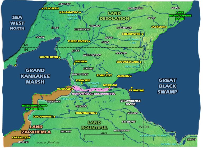
We first show you the ancient Kankakee Marsh. Map below. At the beginning of my research, I looked up the Grand Kankakee Marsh. I found information from northern Indiana organizations and researchers on both historical and environmental aspects of the marsh. The Hoosier Valley Railroad Museum shared that the Grand Kankakee Marsh was known as the “Everglades of the North” and had once covered more than 500,000 acres. From just this information, I started to understand the vastness of what this marsh used to be, and it had me wondering what had happened to it. How could something so big disappear?
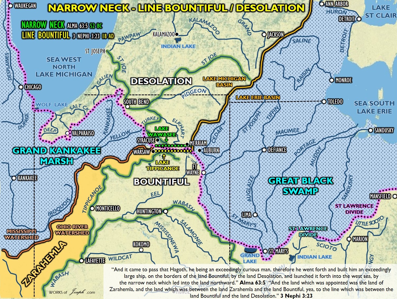
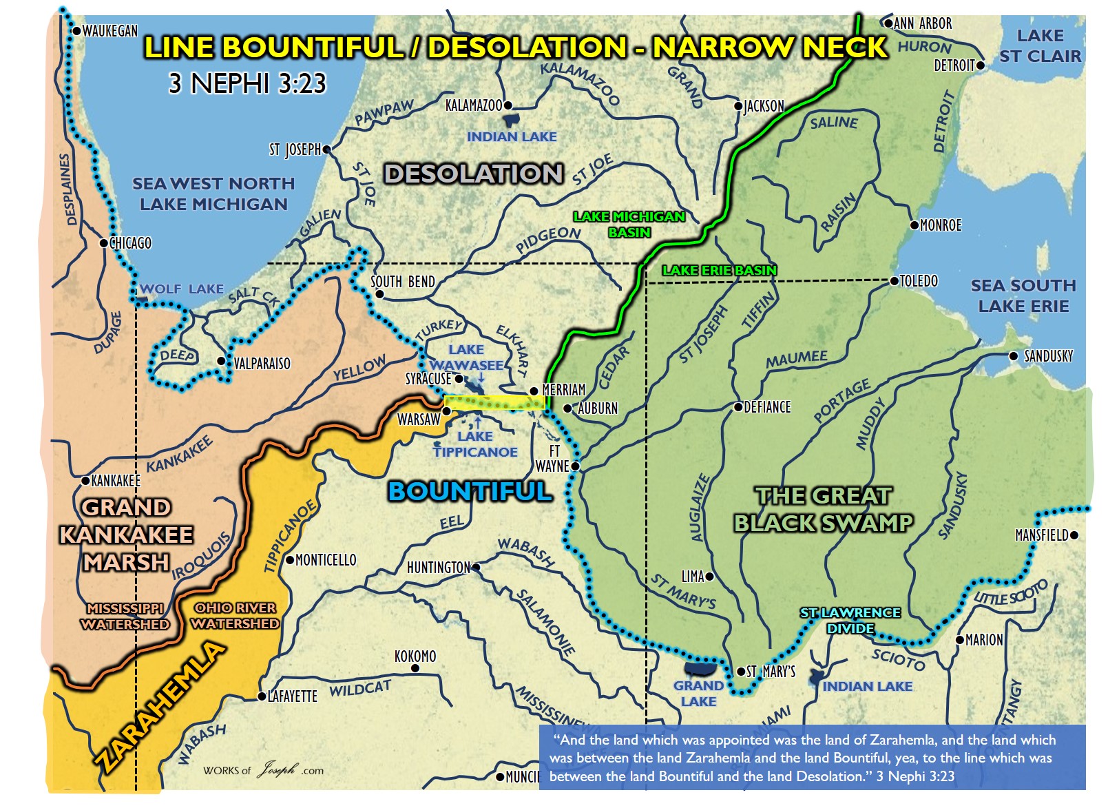
In this article we are speaking about the “Narrow Neck” in Alma 63, not the Narrow Neck of Land” in Ether 10, which is the Niagara Peninsula. The “Narrow Neck” is between the two Indiana cities of Merriam and Warsaw. The “Narrow Neck” is also the location of the “Line Bountiful” found in 3 Nephi 3:23. The term “Narrow Neck of Land” was a Jaredite location, not a Nephite one.
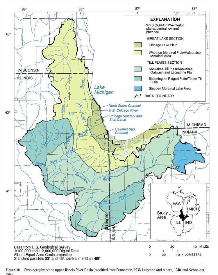
“For thousands of years, the Kankakee River meandered from the area that would in time become South Bend across the northwest corner of Indiana and into Illinois. This lazy river nurtured the largest inland wetlands in the United States — the Grand Kankakee Marsh. Before European settlement, local peoples enjoyed its bountiful resources and shelter. (See Map Below).
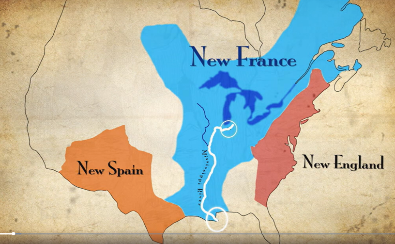
French explorer LaSalle canoed down the Kankakee River in 1679 on his voyage of discovery to the Mississippi. This marsh was home to an amazing diversity of plants, birds, fish and animals that supported a local economy built around fur trade, hunting, fishing and farming. See map left.
After the Civil War, efforts to drain the Grand Kankakee Marsh began in earnest. Networks of drainage ditches were dug to carry the water out of the marsh. Massive steam-powered dredge boats dug straight channels through the marsh reducing the length of the Kankakee River by over half. These channels made it possible to easily cut down and transport the old-growth hardwood forest.” Source
NARROW NECK- Where Hagoth built his ships. On Lake Michigan lower east side following Lake Michigan’s coast along the St Lawrence Continental Divide to the St. Joe River. Anciently the Grand Kankakee Marsh extended south of Lake Michigan and the Great Black Swamp extended west of Lake Erie. The neck running E/W was 30 miles between Warsaw, IN and Merriam IN. Alma 63:5
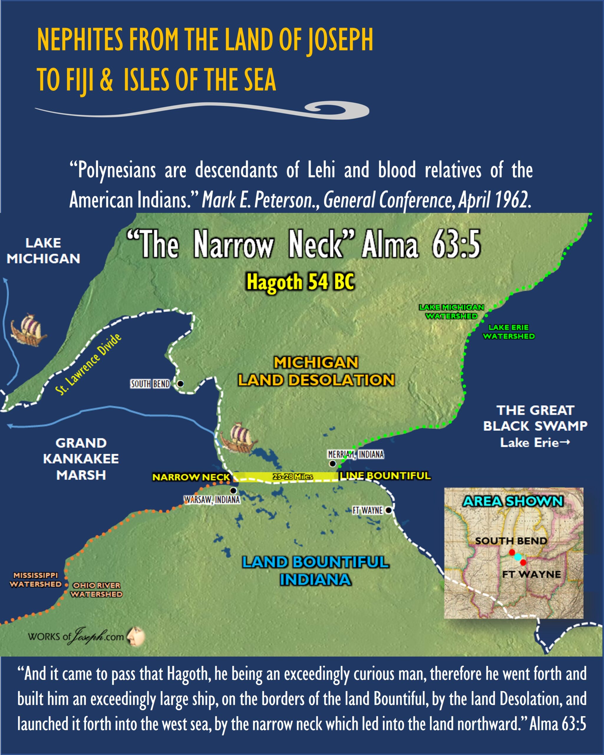
Let’s Explain Hagoth:
“Although some scholars insist that the Polynesian ancestors came from the Orient and sailed east to settle Polynesia, the Church of Jesus Christ of Latter-day Saints has always taught that they sailed west from America. In 1818, Stuart Meha, a Māori Latter-day Saint from New Zealand, sent a telegram to the Church leaders. Reply, “I would like to say to you brethren and sisters from New Zealand, you are some of Hagoth’s people, and there is NO PERHAPS about it!” Continuing, Joseph F. Smith told how it had been given to him by the spirit, while laboring in Hawaii, that the Polynesians were descendants of Lehi.” Longer Hagoth blog here: 
Closeup of the Line Bountiful in 3 Nephi 3:23, between Merriman and Warsaw, Indiana. Desolation was also the location of the Hill Cumorah which is further north east from this map.
“Not long ago, the Grand Kankakee Marsh saturated nearly a million acres across Northern Indiana and into a portion of Illinois. This unique ecological landscape was home to some of the highest concentrations of wildlife on the planet, with waterfowl so numerous they literally blackened the sky. Louis the XIV claimed this land as part of “New France,” The marsh was once known as Chicago’s food pantry.
Many sought the riches of the marsh, including industrialists who made their fortunes from its seemingly endless natural resources. But it all came at the expense of the environment – today less than 5% of the Grand Kankakee Marsh has survived man’s advances. But with a better understanding of wetlands’ important role in the environment, there is a renewed effort to restore part of what was lost.” https://www.lakeshorepublicmedia.org/evergladesofthenorth
The Grand Kankakee Marsh: A Forgotten Natural Wonder
“Known as the “Everglades of the North,” the Grand Kankakee Marsh was an expansive wetland covering a vast swath of northern Indiana. Excursion trains along the former Chesapeake & Ohio rail line travel through a portion of the former marsh as passengers are delighted by wildlife, trees, and wildflowers.
The railroads in the area once brought many hunters, trappers, and fishermen into the marsh from the Chicago region, returning them home with their bounties. The railroads also transported grasses back into the city for use in packaging. There were numerous hunting lodges located throughout the marshland, including at English Lake.
Once a magnificent natural wonder, the marsh stood as a testament to the beauty and diversity of wetland ecosystems in the United States. Spanning across the region, this vast marshland teemed with rich flora and fauna, serving as a crucial habitat for numerous species. Sadly, due to decades of human intervention and drainage efforts, the Grand Kankakee Marsh is now a shadow of its former self.
A Jewel of Biodiversity
The Grand Kankakee Marsh was a thriving ecosystem known for its extraordinary biodiversity. The marshland covered over 500,000 acres, encompassing diverse wetland habitats such as swamps, marshes, and shallow lakes. It was home to a remarkable array of plant species, including cattails, sedges, water lilies, and various species of aquatic grasses. This abundance of plant life supported a multitude of animal species, including migratory birds, waterfowl, turtles, frogs, and diverse fish populations.
Native American Heritage
Before European settlement, the Grand Kankakee Marsh played a vital role in the lives and culture of Native American tribes such as the Miami and Potawatomi. These tribes recognized the marsh’s ecological significance, relying on its resources for sustenance and utilizing its wetlands for transportation and trade. The marsh was not only a source of food and materials but also held spiritual importance within their cultural practices.
Human Impact and Drainage
In the late 19th and early 20th centuries, as the United States underwent rapid industrialization and agricultural expansion, the Grand Kankakee Marsh faced significant human intervention. Draining the marsh to convert it into farmland became a prevailing notion, driven by the desire for economic development and land use conversion. Canals were constructed to channelize and drain the wetlands, and large-scale projects attempted to straighten the meandering Kankakee River. As a result, the natural hydrological balance was disrupted, leading to irreversible changes in the marsh’s ecosystem.
Environmental Consequences
The extensive drainage efforts had profound environmental consequences for the Grand Kankakee Marsh. As the wetlands diminished, so did the habitat for numerous plant and animal species. Migratory birds lost a critical stopover point during their long journeys, and waterfowl populations declined. The altered water flow and increased sedimentation disrupted the delicate balance of the aquatic ecosystem, affecting fish populations and water quality. The loss of wetland vegetation also resulted in decreased water retention and increased flooding in surrounding areas.
Restoration Efforts and Future Prospects
Recognizing the ecological and cultural value of the Grand Kankakee Marsh, efforts have been made in recent years to restore and preserve what remains. Various organizations, environmental groups, and government agencies have been collaborating to reconstruct wetlands, improve water quality, and promote habitat restoration. These initiatives aim to reintroduce native plant species, recreate natural hydrological conditions, and support the recovery of wildlife populations. The goal is to revive the Grand Kankakee Marsh’s ecological functions while providing recreational opportunities and environmental education for the surrounding communities.
The nearby Kankakee Fish & Wildlife Area contains more than 4,000 acres of habitat for migrating waterfowl and other wildlife. Bald eagles can sometimes be sighted along the tracks along with other birds of prey. Many songbirds, butterflies, deer, and other animals call the area home. Wildflowers, tall grasses, and riparian plants can be seen from the train as we pass through remnants of the Grand Kankakee Marsh.” Source
3-Necks in the Book of Mormon
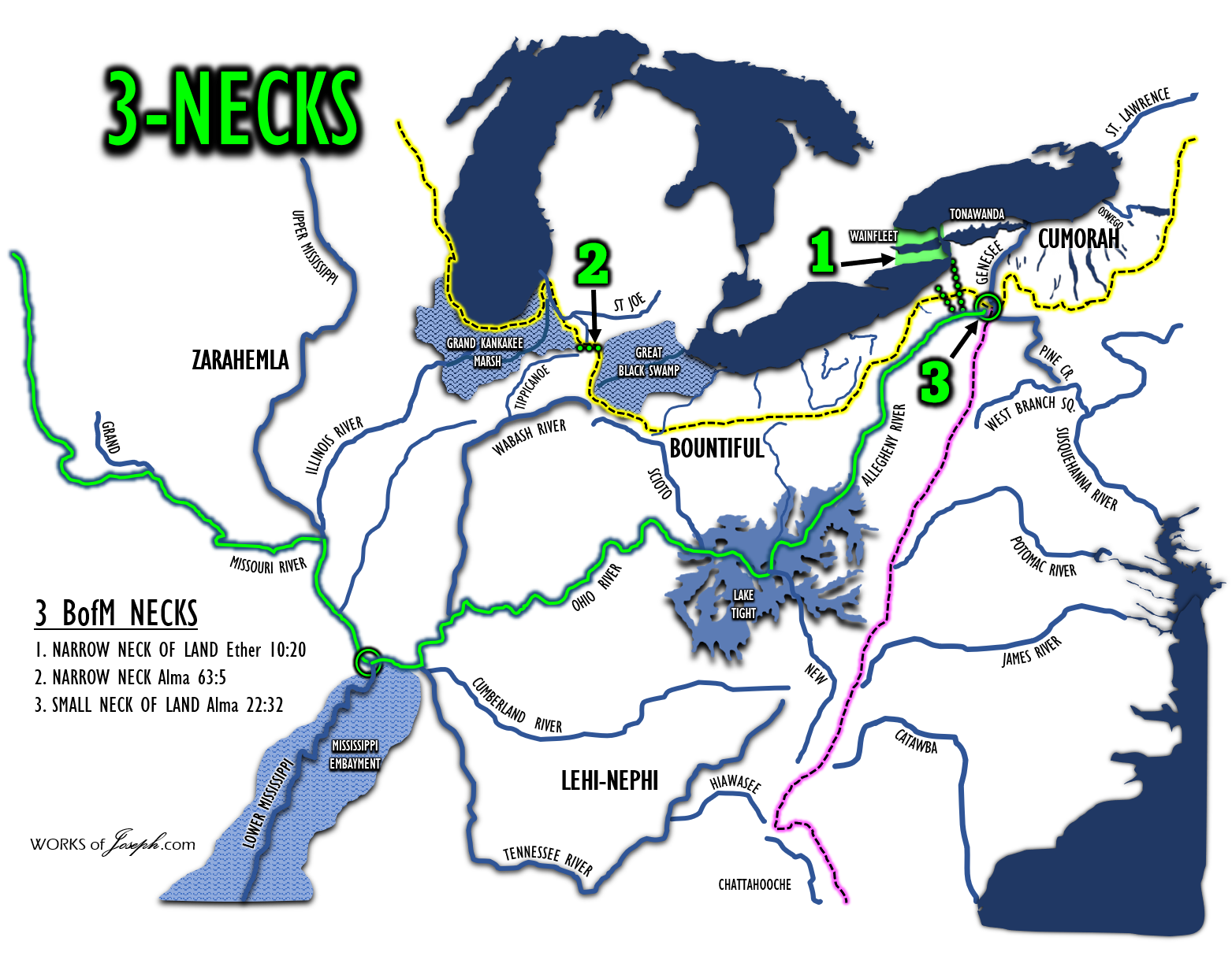
Above we have spoken about the “NARROW NECK”, repeated briefly below:
NARROW NECK- Where Hagoth built his ships. On Lake Michigan lower east side following Lake Michigan’s coast along the St Lawrence Continental Divide to the St. Joe River. Anciently the Grand Kankakee Marsh extended south of Lake Michigan and the Great Black Swamp extended west of Lake Erie. The neck running E/W was 30 miles between Warsaw, IN and Merriam IN. Alma 63:5
We will now briefly share with you about the other two NECKs spoken of in the Book of Mormon.

NARROW NECK OF LAND- Lake Ontario divides the land at Hamilton, OT Canada, and Lake Erie divides the land at Buffalo, NY, and at Toledo, OH. In Central America the ”land divides the sea”. (Isthmus of Tehuantepec) Lake Ontario and Lake Erie are seas, where the “sea divides the land” as quoted in Ether. Ether 10:20. The N/S distance from Lake Erie to Lake Ontario is only about 24 miles wide. This scripture is from the Jaredite people. It shows like in the picture below that the Jaredites said “They built a great city (Buffalo) by the narrow neck of land by the place where the sea divides the land.” It does not say it was a place where the land divides the sea as they show in Mesoamerica in the map right.
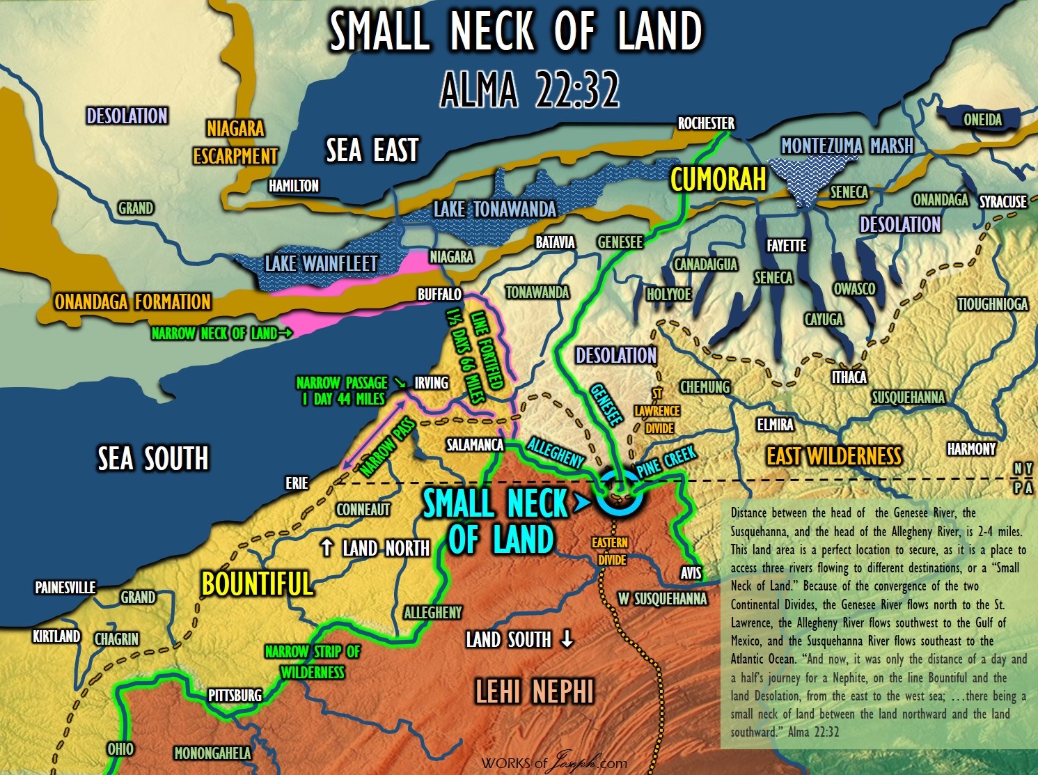
SMALL NECK OF LAND- Allegheny, Susquehanna, and Genesee head-river gaps. (Triple Divide Map left) Only 6 miles between each of these three river heads, where the two Continental Divides meet. (St Lawrence and Eastern Divide) Anciently this location was called the Forbidden Path, and was a strategic defensive location, hunting area, and buffer zone for the Native Americans to protect their south land. “Leading directly into the heart of the central New York Iroquois heartland, the Forbidden Path stood at a strategic transportation break linking river systems ultimately flowing into Chesapeake Bay, the Great Lakes, and the Ohio Valley.” (Journey on the Forbidden Path: Volume 89, Part 2 By Christian Frederick Post, John Hays) Alma 22:32. This is the gate of the Narrow Strip of Wilderness and the place which is the “Nearly” in “nearly surrounded by water.” Don’t confuse this location with the more well known, “Narrow Neck of Land” nor the “Narrow Neck.”