
ANNOTATED EDITION OF THE BOOK OF MORMON – MORONI’S AMERICA MAPS
“At the onset, we stipulate that the spiritual messages of the Book of Mormon are more important than its geography. And yet the historicity—the historical accuracy—of the book is also important. The Book of Mormon could not accomplish its objective if it was not a true history of real people. As a restored history, it is a tangible symbol of the restored gospel. The book’s very existence is a manifestation of the reality of divine revelation in our day.
When we read the Book of Mormon under the light Joseph and Oliver provided, we see it in a completely new way. We come to realize that the Gospel was restored where it was lost. The light of the Gospel was extinguished in the Old World when the Apostles were killed and the Church fell into apostasy, but that light endured in the New World until the Nephite civilization was finally destroyed in New York around 400 A.D. What better place for the restoration of the Gospel than the scene of its disappearance? And from the New World, the gospel is taken back to the Old World.
We come to realize that the early history of the Church paralleled Nephite history, in reverse. The Nephites were destroyed in New York, so the Church was established there. The Nephites had been driven from Zarahemla and diminished on their way to Cumorah, so the Church grew on its way to Zarahemla from Cumorah. Joseph Smith was eventually buried in an ancient Nephite cemetery in Nauvoo—across the river from Zarahemla.
Finally, we come to realize that just as the Gospel was once taken from the entire Earth, now it is spreading to the entire Earth. And the Book of Mormon is the means for making that possible…
My objective in writing the book Moroni’s America, including the maps (see p. 523), was not to persuade or convince anyone of anything. I have simply assembled and organized information that I think everyone interested in the Book of Mormon should be aware of. While I think the geography I present is consistent with the text and makes more sense than alternatives I’ve read, the most important consideration is whether a given map corroborates and supports what Joseph Smith and Oliver Cowdery taught about the Hill Cumorah in New York, including their specific teachings in Letter VII.
 The New York Cumorah doesn’t answer other questions about Book of Mormon geography, but it is a firm “pin in the map” (see p. 523 Annotated Book of Mormon) given to us by Joseph and Oliver, who knew Cumorah was in New York because they personally visited Mormon’s depository there (Mormon 6:6). Every prophet and apostle who has commented about Cumorah since then, including members of the First Presidency speaking in General Conference, have affirmed what Joseph and Oliver taught. In my view, no legitimate geography can reject what they said was a fact.
Over the years, people have made so-called ‘abstract’ maps based on their subjective interpretation of the text. While these may be helpful for envisioning a general relationship among named locations, such efforts cannot possibly derive a definite real-world setting because the information in the text is too vague. However, when we start with Cumorah in New York and think of Mormon and Moroni describing things from their earth-bound perspective, the hundreds of geography-related passages make sense in the real world. Joseph Smith specifically rejected a hemispheric geography when he wrote the Wentworth letter and he rejected a limited model based solely in New York when he wrote his letter to Emma during Zion’s Camp. For these and other reasons I’ve explained in my books and blogs, I suggest we consider the North American setting for the Book of Mormon.
Each element is framed as a proposal or plausible interpretation, always subject to revision with more information. Feel free to agree or disagree. Each of us makes our own decisions about what to believe, and I recognize how complex that process is. And yet, well informed decisions tend to be better than uninformed decisions—especially uniformed decisions that reject what the prophets have taught about the New York Cumorah.” Jonathan Neville The Annotated Book of Mormon by David Hocking and Rod Meldrum page 522
 “I was first taught and inspired about the North American Model by Rod Meldrum. The Works of Joseph maps included in this Annotated Edition of the Book of Mormon were created after being inspired while reading the book Moroni’s America by Jonathan Neville. However, I want others to know that the spiritual messages of the Book of Mormon are far more important than the geography. But I also believe the historical accuracy is critical to my full comprehension of the ‘most correct book’ (Joseph Smith Jr.) on the earth. Many Latter-day Saints agree that the Garden of Eden, Adam-ondi-Ahman, and Cumorah are located in North America, and most know that the New Jerusalem will be built upon the American Continent (Articles of Faith #10, Doctrine and Covenants 84:1-4). It just makes sense to me that the Book of Mormon history primarily occurred in the United States of America, as other sacred events did.
The maps have been created based on Joseph Smith’s writings that the Hill Cumorah is in Manchester, New York (Letter VII), that Joseph did have a vision of Zelph who was a Book of Mormon Chieftain in Illinois (Joseph Smith Papers), and Joseph did write a letter to Emma June 4, 1834 telling her that he was ‘wandering over the plains of the Nephites,’ in Illinois, Indiana and Ohio. (Joseph Smith Papers). I also believe the Promised Land spoken of in the Book of Mormon is indeed the choice land of the United States. I desire that these visual representations of Book of Mormon events will inspire you and teach you more about the spiritual message of The Book of Mormon, Another Testament of Jesus Christ.” Rian Nelson The Annotated Book of Mormon by David Hocking and Rod Meldrum page 522
 “Whenever I hear anyone, including myself, say, “I know the Book of Mormon is true,” I want to exclaim, “That’s nice, but it is not enough!” We need to feel, deep in “the inmost part” of our hearts, that the Book of Mormon is unequivocally the word of God. We must feel it so deeply that we would never want to live even one day without it. I might paraphrase President Brigham Young in saying, “I wish I had the voice of seven thunders to wake up the people” to the truth and power of the Book of Mormon ” President Russell M. Nelson The Book of Mormon: What Would Your Life Be Like without It?
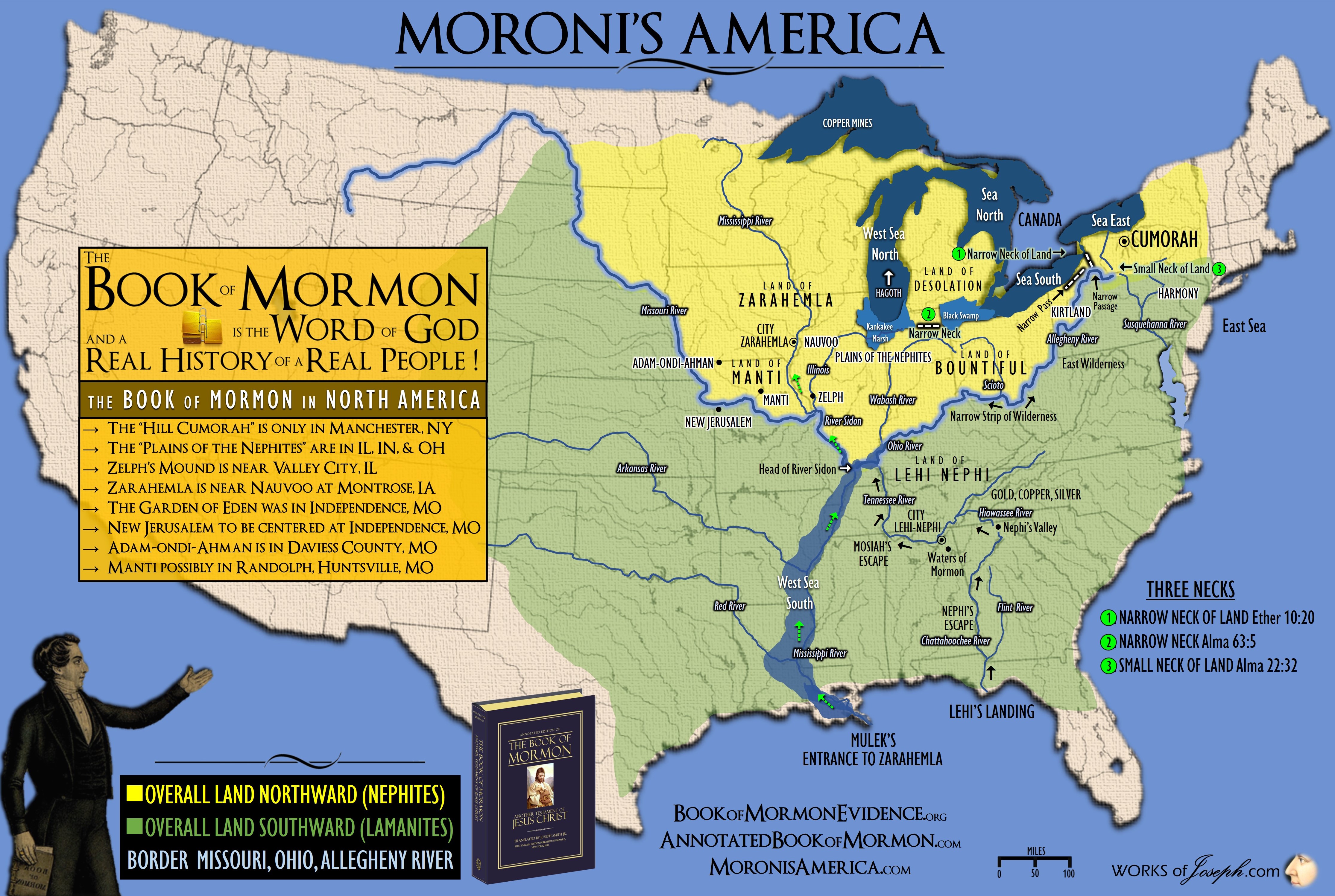
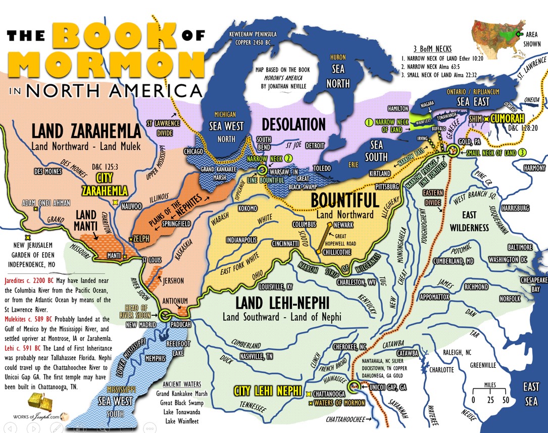
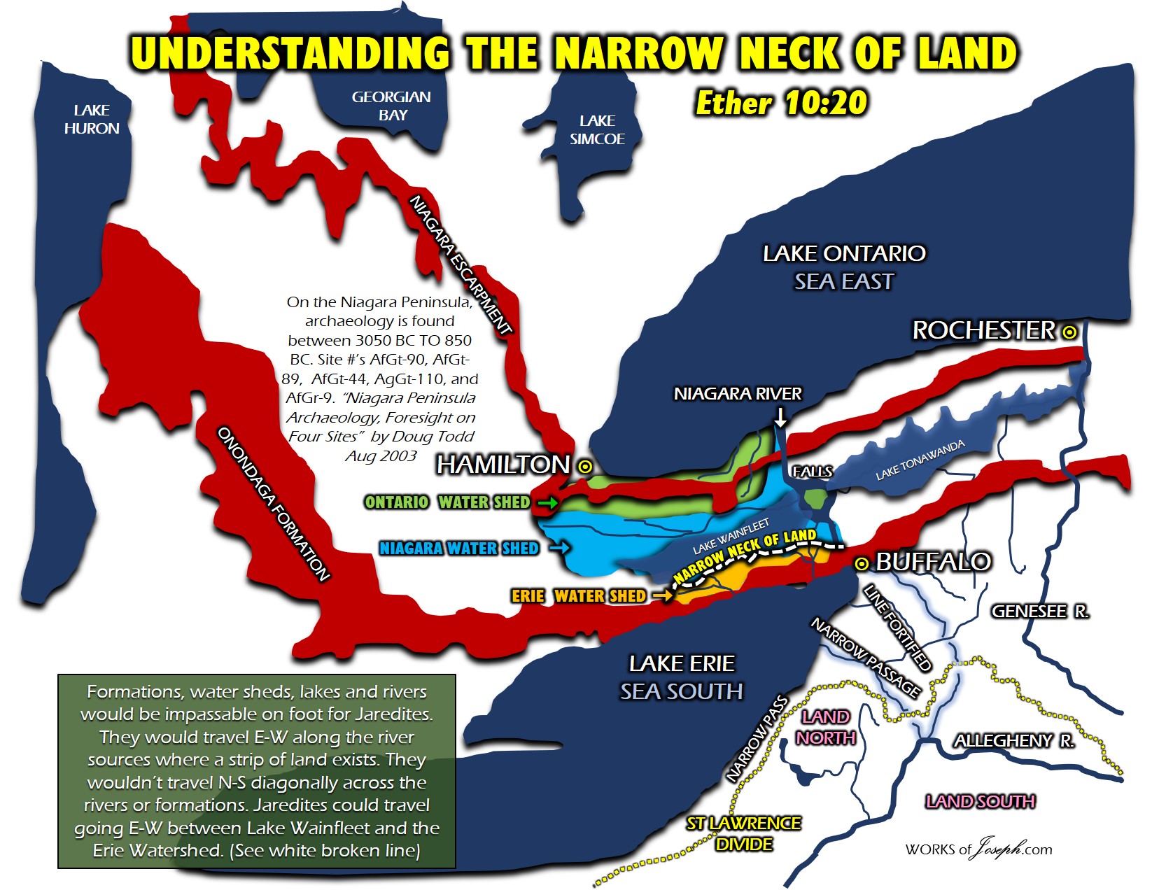
UNDERSTANDING NECKS, LINES, PASSAGES, AND THE NARROW NECK OF LAND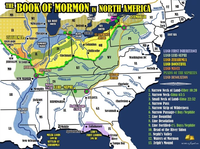
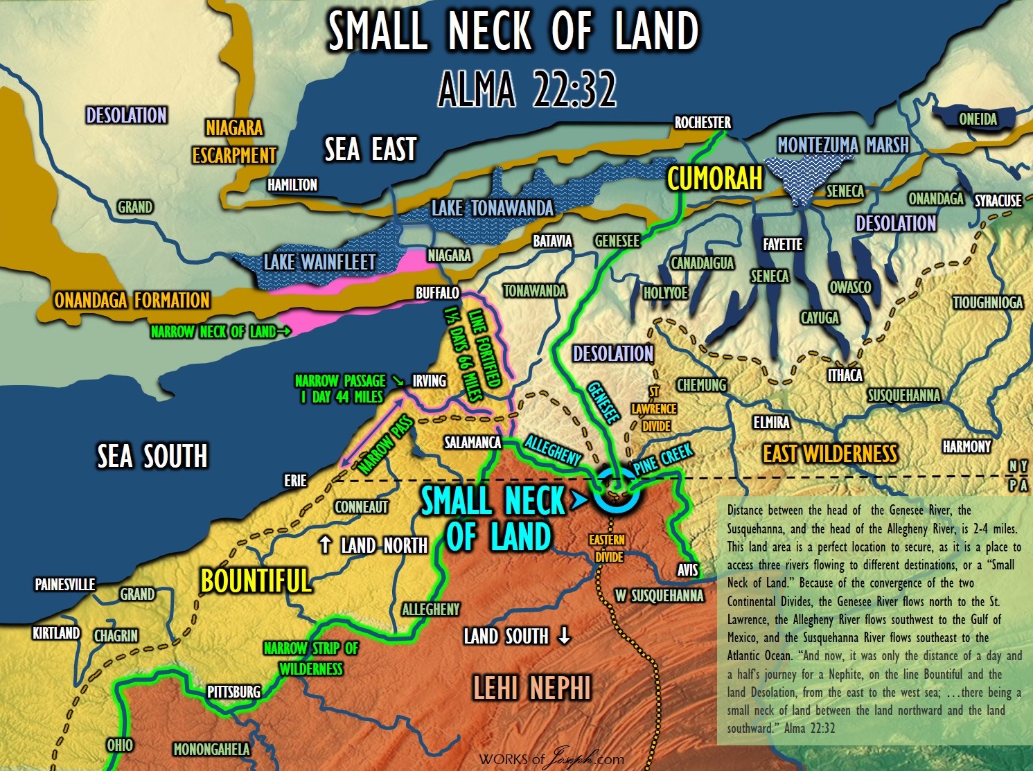
NARROW PASS- This could be described in many areas in the Heartland of America, as the geography has changed over the years. We know the Great Lakes have receded since ancient times. Passes could include: The land pass between Lake St. Clair and Lake Huron (St. Clair River), or Land between Lake St Clair and Lake Erie. (Detroit River), or E-W pass between Lake Erie and Lake Ontario near Niagara Falls. The best choice is the land E-W between the south side of Lake Erie and the Allegheny River, from Irving, NY to Salamanca, NY. Lake Erie was larger anciently and is bordered on the south by the St Lawrence Divide.Mormon 3:5 (Near Buffalo, NY by the Narrow Neck of Land)
Alma 50:34. (Line Desolation between Lake Erie and the Allegheny River.)
Alma 52:9 (Line Bountiful is an E/W Continental Divide of 30 miles between Warsaw, IN, and Auburn, IN.
NARROW PASSAGE- Begins on the south side of Lake Erie at Irving NY, following the Cattaraugus Creek south through Zoar Valley on the Little Valley Creek, ending at the Allegheny River which is where the land southward begins. A day’s journey for a Nephite of 44 miles. “On the south side of Lake Erie, there is a series of old fortifications, running from the Cattaraugus creek to the Pennsylvania line, a distance of fifty miles; some are two, three, and four miles apart, and some within half a mile.” Clinton, De Witt. A Memoir On The Antiquities Of The Western Parts Of The State Of New-York. Mormon 2:29
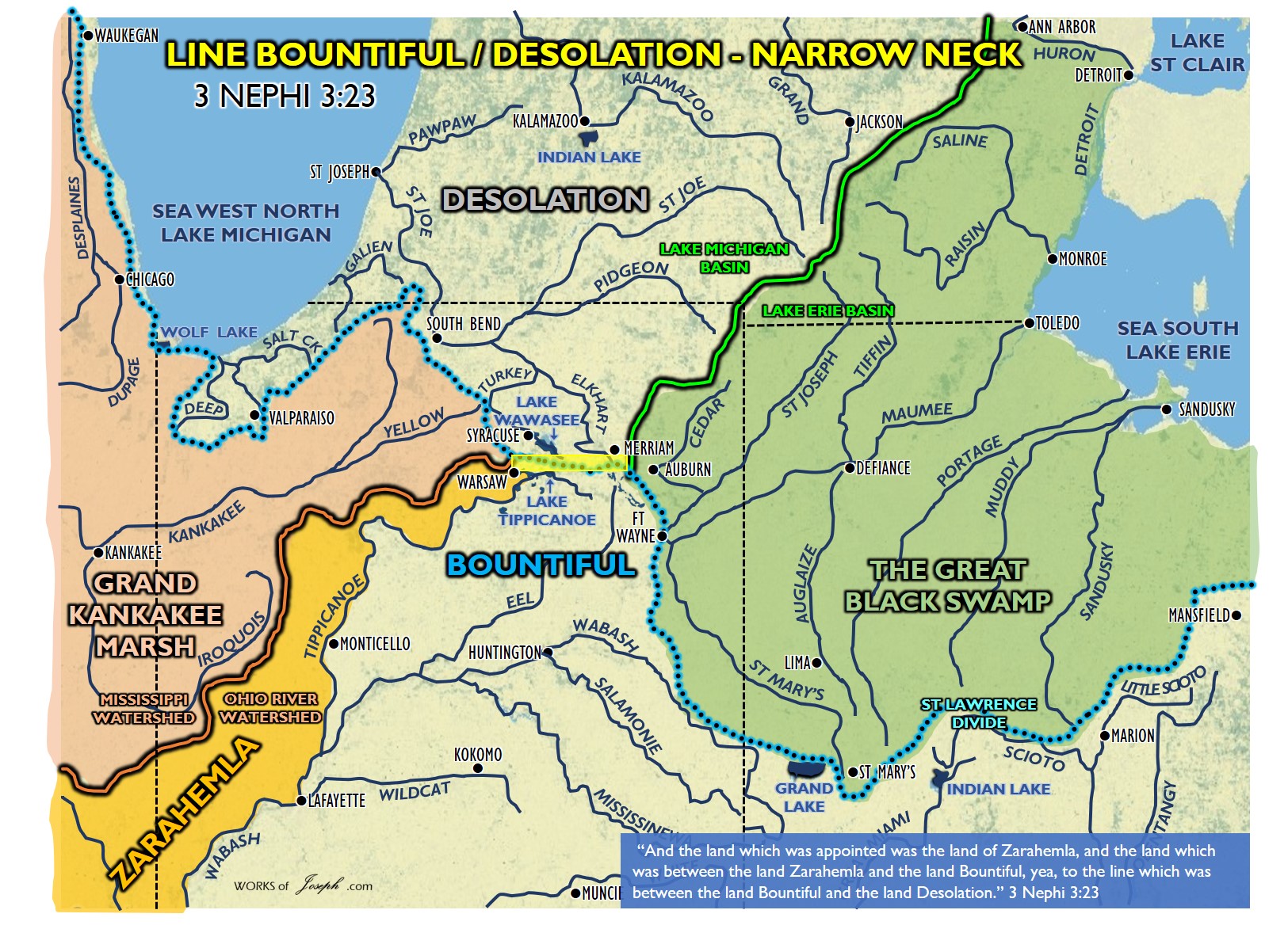
NARROW NECK- Where Hagoth built his ships. On Lake Michigan lower east side following Lake Michigan’s coast along the St Lawrence Continental Divide to the St. Joe River. Anciently the Grand Kankakee Marsh extended south of Lake Michigan and the Great Black Swamp extended west of Lake Erie. The neck running E/W was 30 miles between Warsaw, IN and Merriam IN. Alma 63:5
Here is a great quote to explain Hagoth: “Although some scholars insist that the Polynesian ancestors came from the Orient and sailed east to settle Polynesia, the Church of Jesus Christ of Latter-day Saints has always taught that they sailed west from America. In 1818, Stuart Meha, a Māori Latter-day Saint from New Zealand, sent a telegram to the Church leaders. Reply, “I would like to say to you brethren and sisters from New Zealand, you are some of Hagoth’s people, and there is NO PERHAPS about it!” Continuing, Joseph F. Smith told how it had been given to him by the spirit, while laboring in Hawaii, that the Polynesians were descendants of Lehi.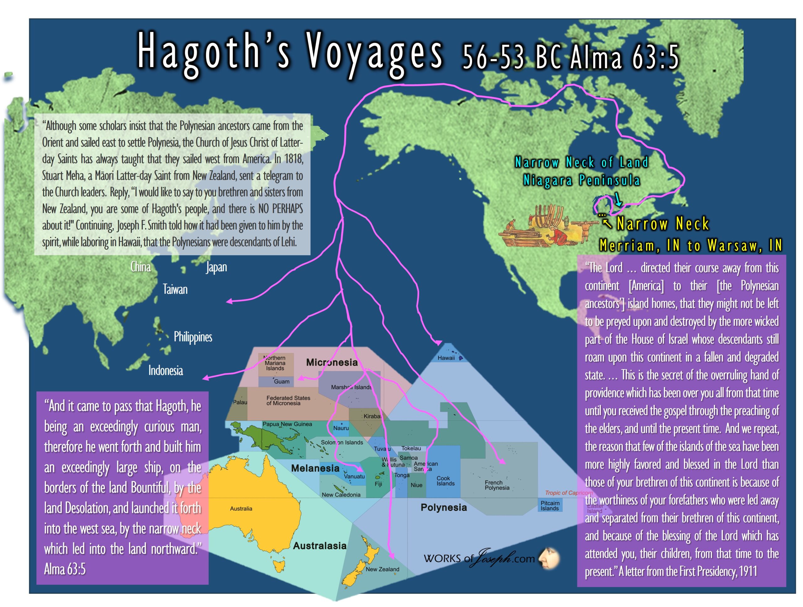
NARROW NECK OF LAND- Lake Ontario divides the land at Hamilton, OT Canada, and Lake Erie divides the land at Buffalo, NY, and at Toledo, OH. In Central America the ”land divides the sea”. (Isthmus of Tehuantepec) Lake Ontario and Lake Erie are seas, where the “sea divides the land” as quoted in Ether. Ether 10:20. The N/S distance from Lake Erie to Lake Ontario is only about 24 miles wide.
SMALL NECK OF LAND- Allegheny, Susquehanna, and Genesee head-river gaps. (Triple Divide) Only 6 miles between each of these three river heads, where the two Continental Divides meet. (St Lawrence and Eastern Divide) Anciently this location was called the Forbidden Path, and was a strategic defensive location, hunting area, and buffer zone for the Native Americans to protect their south land. “Leading directly into the heart of the central New York Iroquois heartland, the Forbidden Path stood at a strategic transportation break linking river systems ultimately flowing into Chesapeake Bay, the Great Lakes, and the Ohio Valley.” (Journey on the Forbidden Path: Volume 89, Part 2 By Christian Frederick Post, John Hays) Alma 22:32. This is the gate of the Narrow Strip of Wilderness and the place which is the “Nearly” in “nearly surrounded by water.” Don’t confuse this location with the more well known, “Narrow Neck of Land.” (3 “NECKS” see # 3,4,5).
NARROW STRIP OF WILDERNESS- The Allegheny, Ohio, Mississippi, and Missouri Rivers act as a west to east fence, across the United States. This is the main border between the Nephites and Lamanites from about Independence MO to Hill Cumorah . The gate of the fence is the Small Neck of Land which is why the Nephites and Lamanites were “nearly” surrounded by water. Alma 22:27. Rivers are well known as a type of wilderness where there are marshes, weeds, and unusable space along both banks of rivers, thus creating a wilderness area where people don’t live, especially if the river bed is low or dry.
LINE BETWEEN/LINE FORTIFIED- Journey for a Nephite from the “Great City” at Buffalo, NY in a straight line to the Allegheny River near Salamanca, NY. Remember everything south of the Allegheny River is the land southward. (66 miles or about a day and a half for a Nephite). North of this line is Desolation and south is the Land Bountiful.
Line Fortified Helaman 4:7
Line Between Alma 50:11
LINE DESOLATION/BOUNTIFUL- The Great Black Swamp anciently went from the west end of Lake Erie to Fort Wayne, Indiana. It occupied what was formerly the southwestern part of proglacial Lake Maumee, a Holocene precursor to Lake Erie. Grand Kankakee Marsh anciently surrounded the south of Lake Michigan. These swamps almost connected W/E along the St Lawrence Divide. The northern Lake Michigan water basin and the southern Mississippi water basin create a line along the St Lawrence Divide of about 30 miles. From about Warsaw, IN to Auburn, IN, is the 30 mile long E/W line the Nephites would have to of defended. 3 Nephi 3:23
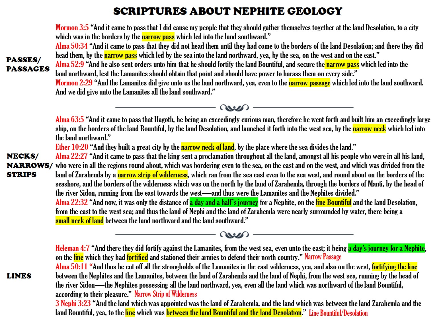
SCRIPTURES ABOUT NEPHITE GEOLOGY
MORMON 3:5 “And it came to pass that I did cause my people that they should gather themselves together at the land Desolation, to a city which was in the borders, by the narrow pass which led into the land southward.”
ALMA 50:34 “And it came to pass that they did not head them until they had come to the borders of the land Desolation; and there they did head them, by the narrow pass which led by the sea into the land northward, yea, by the sea, on the west and on the east.”
ALMA 52:9 “And he also sent orders unto him that he should fortify the land Bountiful, and secure the narrow pass which led into the land northward, lest the Lamanites should obtain that point and should have power to harass them on every side.”
MORMON 2:29 “And the Lamanites did give unto us the land northward, yea, even to the narrow passage which led into the land southward. And we did give unto the Lamanites all the land southward.”
ALMA 63:5 “And it came to pass that Hagoth, he being an exceedingly curious man, therefore he went forth and built him an exceedingly large ship, on the borders of the land Bountiful, by the land Desolation, and launched it forth into the west sea, by the narrow neck which led into the land northward.”
ETHER 10:20 “And they built a great city by the narrow neck of land, by the place where the sea divides the land.”
ALMA 22:27 “And it came to pass that the king sent a proclamation throughout all the land, amongst all his people who were in all his land, who were in all the regions round about, which was bordering even to the sea, on the east and on the west, and which was divided from the land of Zarahemla by a narrow strip of wilderness, which ran from the sea east even to the sea west, and round about on the borders of the seashore, and the borders of the wilderness which was on the north by the land of Zarahemla, through the borders of Manti, by the head of the river Sidon, running from the east towards the west—and thus were the Lamanites and the Nephites divided.”
ALMA 22:32 “And now, it was only the distance of a day and a half’s journey for a Nephite, on the line Bountiful and the land Desolation, from the east to the west sea; and thus the land of Nephi and the land of Zarahemla were nearly surrounded by water, there being a small neck of land between the land northward and the land southward.”
HELAMAN 4:7 “And there they did fortify against the Lamanites, from the west sea, even unto the east; it being a day’s journey for a Nephite, on the line which they had fortified and stationed their armies to defend their north country.”
ALMA 50:11 “And thus he cut off all the strongholds of the Lamanites in the east wilderness, yea, and also on the west, fortifying the line between the Nephites and the Lamanites, between the land of Zarahemla and the land of Nephi, from the west sea, running by the head of the river Sidon—the Nephites possessing all the land northward, yea, even all the land which was northward of the land Bountiful, according to their pleasure.”
3 NEPHI 3:23 “And the land which was appointed was the land of Zarahemla, and the land which was between the land Zarahemla and the land Bountiful, yea, to the line which was between the land Bountiful and the land Desolation.”
There are 3 unique mentions in the Book of Mormon about NECKS! All in different locations.
- NARROW NECK OF LAND Ether 10:20
- NARROW NECK Alma 63:5
- SMALL NECK OF LAND Alma 22:32
These three unique mentions of NECK are all in different locations in North America. THE NARROW NECK OF LAND is defined below:
Lake Ontario (a sea) divides the land at Hamilton, OT Canada, and Lake Erie (s sea) divides the land at Buffalo, NY.
In Central America, the ”land divides the sea”. (Isthmus of Tehuantepec) which is opposite of what the scripture says about the “sea divides” the land.
Lake Ontario and Lake Erie are seas, where the “sea divides the land” as quoted in Ether. Ether 10:20. The N/S distance from Lake Erie to Lake Ontario is only about 24 miles wide and in Central America it is 140 miles, which doesn’t sound very narrow to me. In the Book of Mormon the Narrow Neck of Land is only described in the Book of Ether, so the Jaredites used it, not the Nephites. There is archaeological verification at the Niagara Peninsula that dates from 800 BC to 3000 BC which is the time of the Jaredites.

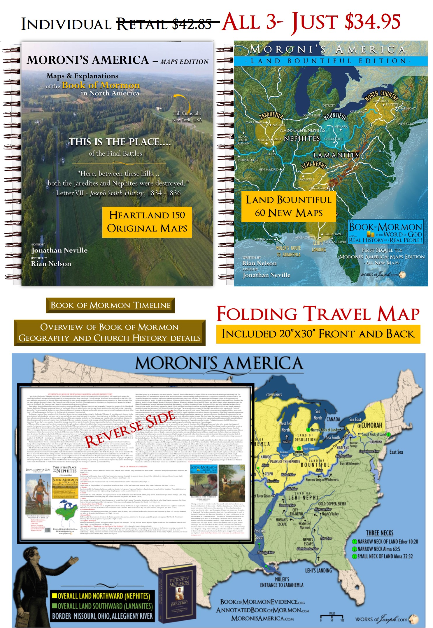
Moroni’s America-Heartland Map Package- BOTH MAP Book’s (210 Maps) + TRAVEL MAP Save 18%
was $42.85 now! $34.95- Click Here!
Maps and Text by Rian Nelson
Great article and very detailed, thanks
Comments are closed.