
Lewiston, NY Mound and Others
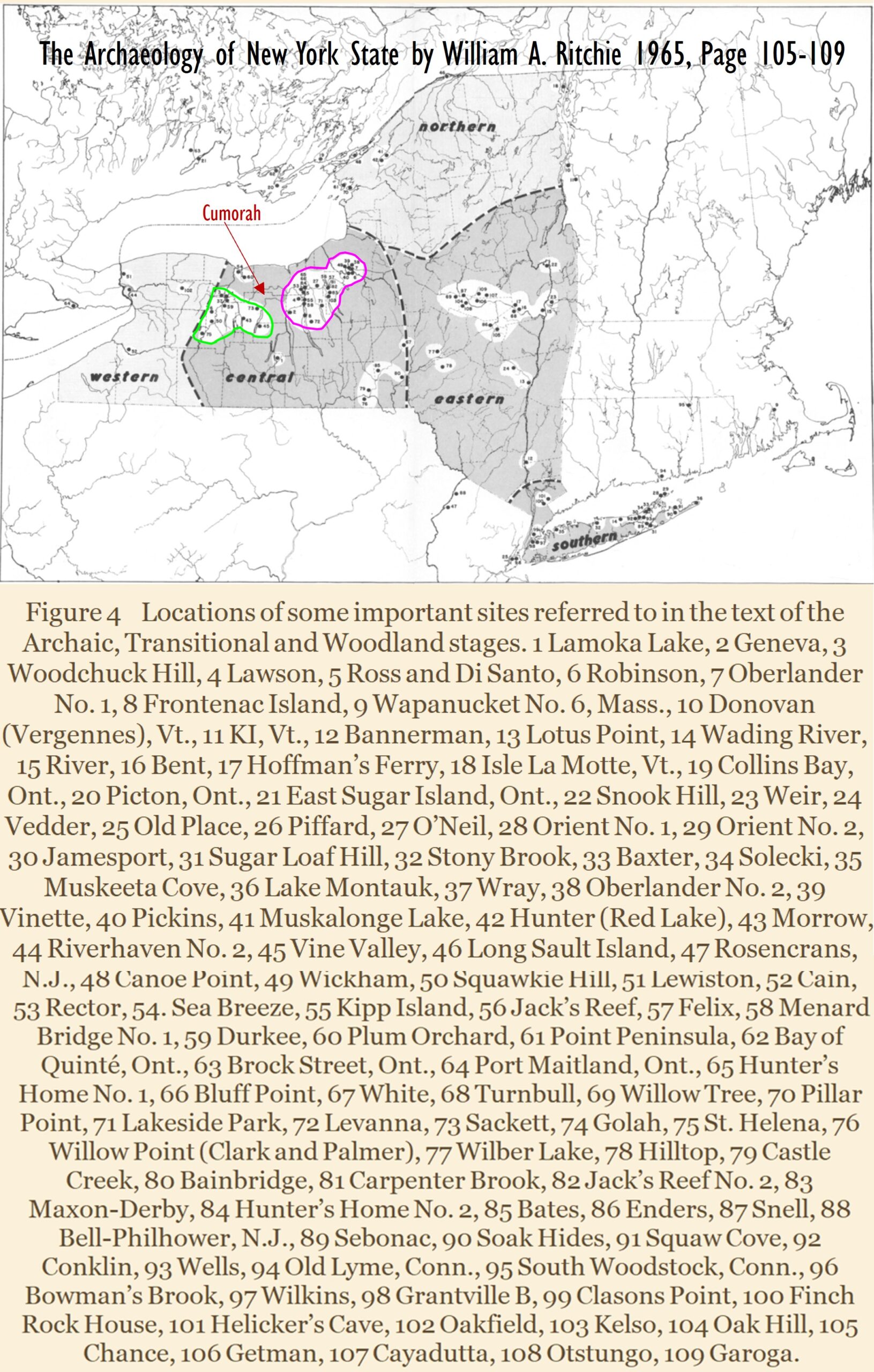
As you see in the map (left) from The Archaeology of New York, you can see 109 ancient sites dated from about 2400 BC (Lamoka) to 1600 AD in New York State, and many near Cumorah. I ask you to look between the green line and the pink like in the map, as you see an absence of mound sites. Could that be indicative that after the final battles at Cumorah, the people chose not to live in those particular areas of Cumorah? There are ancient historical words that mention a “Bloody Hill” or the “Hill that ran Red all Day”. See my blog here, about THE WAR OF BARK EATERS AND WHERE THE BLOOD RAN RED ALL DAY (Hill Cumorah Battle?)
You will find below over 25 books or articles written by non-Mormons that verify evidence of hills, mounds, ditches, artifacts, forts, bones and arrowheads during the Book of Mormon timeline of 600 BC to 421 AD found all over the eastern area of North America, from Florida to Tennessee to Illinois, to Ohio and in New York. I also share with you over 15 blogs or articles I have written of additional massive evidence you can research. Of course you can research and pray for personal revelation,
“Must be like God. — April 10, 1842. Joseph Smith said, “If you wish to go where God is, you must be like God, or possess the principles which God possesses, for if we are not drawing towards God in principle, we are going from Him and drawing towards the devil. * * A man is saved no faster than he gets knowledge, for if he does not get knowledge, he will be brought into captivity by some evil power in the other world, as evil spirits will have more knowledge, and consequently more power than many men who are on the earth. Hence It needs revelation to assist us and give us knowledge of the things of God.” A Compendium of The Doctrines Of The Gospel. Franklin D. Richards, of the Twelve Apostles of the Church of Jesus Christ of Latter-day Saints, and Elder James A. Little, Salt Lake City, Utah: Entered according to Act of Congress in the year 1882
If you READ, Truth can be found!

Historical Verification of the Book of Mormon in North America
Non-Mormon Archaeology and Research 600 BC to 421 AD
- Ancient Monuments Of The Mississippi Valley By E. G. Squier, Am., And E. H. Davis, M.D. Accepted For Publication By The Smithsonian Institution, June 1847
- Aboriginal Monuments Of The State Of New York Comprising The Results Of Original Surveys And Explorations; With An Illustrative Appendix, By E. G. Squier, A.M.1849
- Archaeology of New York State 1965 by William A. Ritchie Or here
- The Archeological History of New York, Volumes 235-238 By Arthur Caswell Parker
Lewiston Mound NY
Lewiston is a village in Niagara County, New York, United States. The population was 2,701 at the 2010 census. The village is named after Morgan Lewis, an early 19th-century governor of New York. It is part of the Buffalo–Niagara Falls Metropolitan Statistical Area.
The Village of Lewiston, NY (also known as Yehęwakwáʼthaʼ[3] in Tuscarora) is within the Town of Lewiston. The Earl W. Brydges Artpark State Park lies at its southern border. Lewiston was selected by Rand McNally as one of the “Top Ten Best Small Towns in America” in November 2012.
Lewiston is situated on the Niagara River, just across the river from Canada. The Niagara River intersects the Niagara Escarpment between Lewiston and Queenston, Ontario, identifying the escarpment’s Lewiston-Queenston section as the geologic origin of Niagara Falls. Over a roughly 12,500 year span, the falls have eroded nearly seven miles south from Lewiston to their present location in Niagara Falls, creating the seven-mile long Niagara Gorge. Lewiston lies halfway between the world-famous Niagara Falls and historic Fort Niagara in Youngstown. Niagara Falls is approximately a ten-minute drive to the south. Visitors from Canada can take the Lewiston-Queenston Bridge across the Niagara River.
Popular summer festivals include the Lewiston Art Festival (the second weekend in August) and the Northwest Jazz Festival (the last weekend in August). The famous Niagara County Peach Festival takes place during the second weekend of September. Several other festivals, such as the Harvest and Hops Festival, take place during the year. Most are held on or near Center Street, the Village’s main street (18F North).
Lewiston recently won an online voting contest sponsored by USA Today and Rand McNally for “Best for Food” small town in America, beating 176 other communities. Lewiston has over 30 locally owned and operated restaurant/food establishments within a mile, primarily on Center Street, catering to a variety of tastes. It was also designated in the same contest as one of the “Top Ten Best Small Towns in America.”
Various cultures of Native American tribes inhabited the Lewiston area for thousands of years, with the earliest known artifacts dating to 5000 B.C. By the 14th century, Iroquoian-speaking peoples inhabited the area. Before the mid-17th century, they had coalesced into the Five Nations, the historic Iroquois tribes of the Haudenosaunee based in present-day New York. In the early 18th century, they were joined by the Iroquoian Tuscarora from the South, who centuries before had migrated from the Great Lakes area to North Carolina. In 1722, the Iroquois accepted the Tuscarora as the Sixth Nation of the confederacy. The Tuscarora had a village here before the American Revolutionary War called Yehęwakwáʼthaʼ.
During the war, Tuscarora and Oneida Iroquois bands allied individually with the colonists or the British. Those who allied with the British went north with Joseph Brant before the end of the war and are part of the Six Nations of the Grand River First Nation in Ontario. Those allied with the American colonists stayed in New York. The Tuscarora Nation of New York is federally recognized and has occupied a reservation at Lewiston since the early 19th century, although in the 1950s state and federal authorities took 22% of their reservation by eminent domain to construct what is now the Robert Moses Power Plant reservoir.[4]
The Village of Lewiston (formerly known as The Landing) was the site of the first European settlement in western New York in 1720, where trading started along the river. French explorers arriving from Canada across the river had visited the area as early as 1615. The village, incorporated in 1822, claims to be the “most historic square mile in America”. It was named after Morgan Lewis, the 3rd Governor of New York.[5]
In addition to its ancient indigenous settlement, Lewiston became historically significant during European development of North America, and strategic in United States and Canadian history. It was the site from which the US invaded Canada in the Battle of Queenston Heights which took place October 13, 1812. It was the first major battle of the War of 1812. A commemorative sign marks the location where the American force embarked to cross the Niagara River. After the Americans lost the battle, a British retaliatory raid in December 1813 burned Lewiston to the ground and killed several civilians. While most American militia deserted, the local Tuscarora natives stood and fought a delaying action which bought enough time for the surviving citizens to escape.[6] The Historical Association has constructed a large scale bronze monument of thanksgiving to the Tuscaroras entitled Tuscarora Heroes Monument that was unveiled on the 200th anniversary of the attack on December 19, 2013.” Wikipedia
History https://en.wikipedia.org/wiki/Lewiston_(village),_New_York
Lewiston-Hopewell Burial Mound
Lewiston, New York 14092, United States
Created By: Nazareth College.jpg")
Information
Address: 43° 9.991′ N, 79° 2.67′ W. Marker is in Lewiston, New York, in Niagara County. Marker can be reached from South 4th Street south of Tuscarora Street.
Hopewell sight
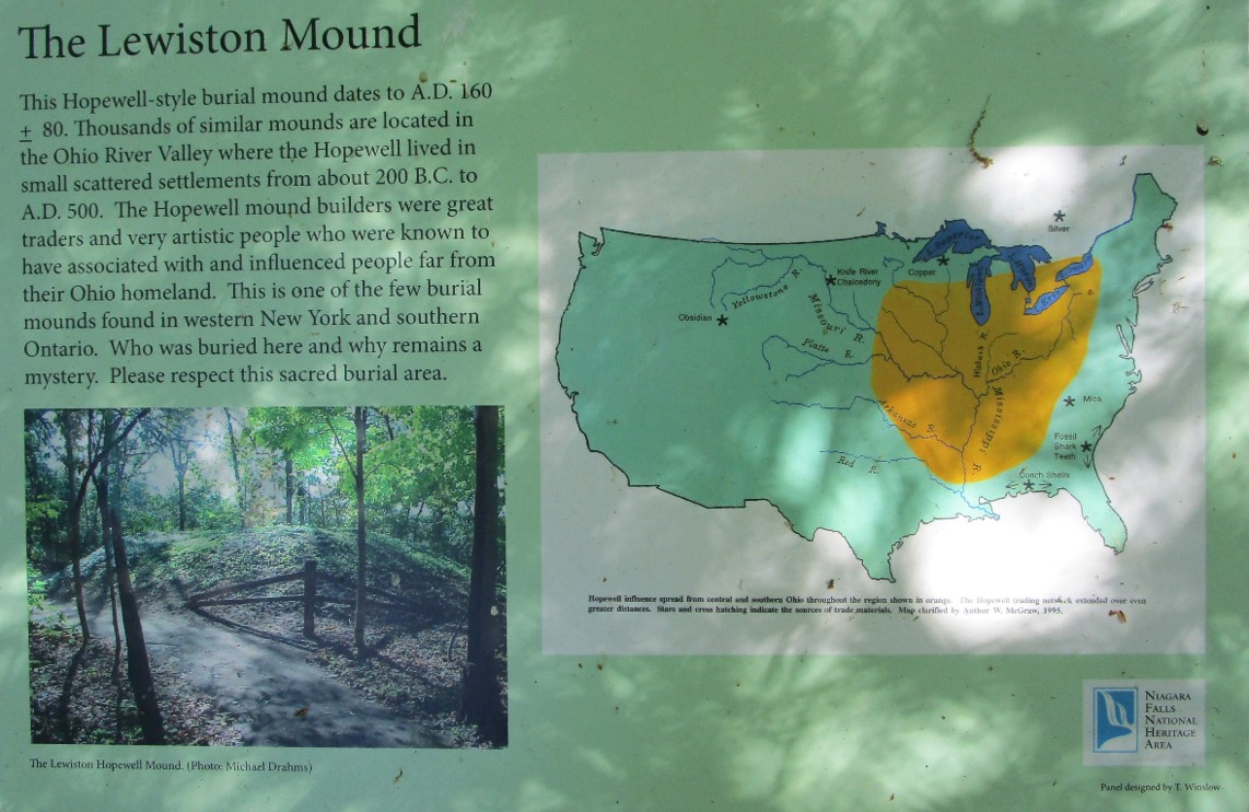
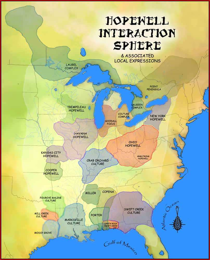
The Hopewell site is located on the grounds of the Earl W. Brydges Artpark. The Hopwell site dates back to the year 200 AD. The Marker can be reached from South 4th Street south of Tuscarora Street. On the grounds of Artpark, the Hopewell sight is found in a wooded section of the land, in between two parking lots. The inscription on the mound of the Hopewell site says that there are “Thousands of similar mounds are located in the Ohio River Valley where the Hopewell lived in small scattered settlements from about 200 B.C. to A.D. 500.”
The inscription also describes that the Hopewell mound creators were associated with and influenced people far from their Ohio homeland. The Hopewell mound builders were also traders and very artistic people. There is no known reason why people were specifically buried here and there are no identities revealed of the people buried here. Lastly the inscription asks for the respect for the sacred burial ground. “In our community, Indian Mounds Park is a cemetery and should be treated as one,” said a police officer in James Walsh’s newspaper article. The police officer in James Walsh’s newspaper article refers to people drinking and doing drugs in a park hidden by the trails that go through an Indian burial ground. In an effort to reroute trails in St. Paul park, a $2.5 million trail reconstruction project, is the subject of a public meeting. While there are people that take this as far too extreme it is essential to try to conserve and respect these burial grounds as it’s important for the history of our country.
Established in 1893, Indian Mounds Regional Park is home to six Indian burial mounds high atop 450 million-year-old limestone and sandstone bluffs overlooking the Mississippi River and downtown St. Paul (Walsh). The burial site spans at least two American Indian cultures. One of which is the Dakota group. And in addition the ancient people known as the Hopewell that house the site you see here in Lewiston NY, at Artpark.
Works Cited:
Walsh, James. Ancient Mounds in an Urban Conflict: A Plan to Reroute Trails at St. Paul Park Draws Praise from American Indian Groups, Pushback from Neighbors., 18 July 2019.
Written by: Alec Petocchi