
Indiana Mounds
Palmyra Register, 1818 says: “The author of this interesting and valuable work, in speaking of the antiquities of the state of Indiana that now exist near Vincennes, County of Knox, says that “On the hills, two miles east of the town, are three large mounds; and others are frequently met with on the prairies, and upland, from White River to the head of the Wabash. They are in every respect similar to those in Franklin County, already described. The French have a tradition, that an exterminating battle was fought in the beginning of the last century, on the ground where Fort Harrison now stands, between the Indians living on the Mississippi, and those of the Wabash. [Zarahemla]. The bone of contention was the lands lying between those rivers, which both parties claimed. There were about 1000 warriors on each side. The condition of the fight was, that the victors should possess the lands in dispute. The grandeur of the prize was peculiarly calculated to inflame the ardor of savage minds. The contest commenced about sunrise. Both parties fought desperately. The Wabash warriors came off conquerors, having seven men left alive at sunset, and their adversaries but five. The mounds are still to be seen where it is said the slain were buried.” Palmyra Register, 21 January 1818 Extract from the Western Gazeteer. In my opinion I believe the Algonquian Language Group are most likely the remaining Lamanites of the final battle of Cumorah. I believe the Iroquois Language Group are most likely the remaining Nephites from the Cumorah battle. After this last battle, there were only Lamanites so-called, yet many Nephites joined them and so did many Mulekites and other races. I propose after this battle in 385 AD at Cumorah, tribes most likely formed again. I believe the two most strident opponents were Algonquian and Iroquois.
Understanding each Native Groups Location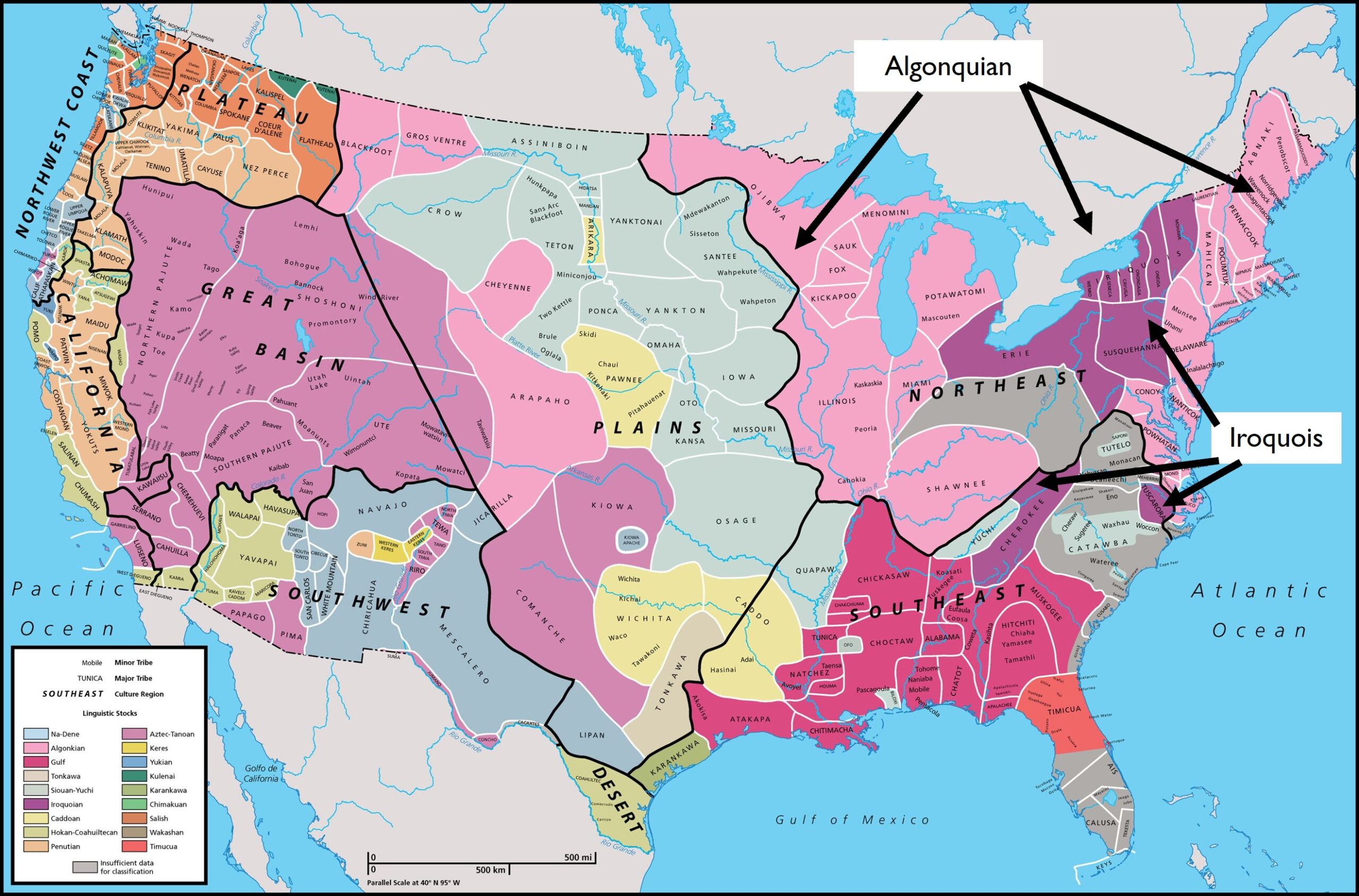
 Wabash Confederacy
“The Wabash Confederacy, also referred to as the Wabash Indians or the Wabash tribes, was a number of 18th century Native American villagers in the area of the Wabash River in what are now the U.S. states of Illinois, Indiana, and Ohio. The Wabash Indians were primarily the Miami, Weas and Piankashaws, but also included Kickapoos, Mascoutens, and others.[Algonquian/I call Remaining Lamanites]. In that time and place, Native American tribes were smaller political units, and the villages along the Wabash were multi-tribal settlements with no centralized government. The confederacy, then, was a loose alliance of influential village leaders (sometimes called headmen or chiefs). In the 1780s, headmen of the Wabash Confederacy allied themselves with a larger, loose confederacy of Native American leaders in the Ohio Country and Illinois Country known as the Northwestern Confederacy, in order to collectively resist U.S. expansion after the American Revolutionary War. In 1786, a Wyandot [Iroquois/ I call a remaining Nephite] messenger named Scotosh warned Congress that the Wabash, Twightwee, and Miami nations would disrupt U.S. surveyors, and Congress promised reprisals if that occurred. This resistance movement culminated with the Northwest Indian War. The alliance with the Western Confederacy ended in 1792 with the Wabash Confederacy signed a treaty with the United States.” Wikipedia
This quote above could have been in reference to the many battles fought between the Lamanites and Nephites in this general area. (See Map Below) The area described in the article above is the area we would call the middle of the Land Zarahemla and the Land Bountiful with the Land Desolation being north of Bountiful. As a matter of fact, my maps show that the Wabash River could possibly be the division point of the Land Bountiful, east of the Wabash, and the Land Zarahemla west of the Wabash to the Mississippi River and beyond, to the Missouri River. The area of Lachoneus of the Book of Mormon and many other battles in Alma 2 and Alma 46 are probably likely just south of the Narrow New bordering on the land Zarahemla and the Land Bountiful on the Wabash River. That area of Missouri to Illinois, to Indiana to Ohio to Pennsylvania were all the direction of the last great battle of the Book of Mormon ending at Cumorah.

There are 3 unique mentions in the Book of Mormon about NECKS!
- NARROW NECK OF LAND Ether 10:20
- NARROW NECK Alma 63:5 (This blog is about this Neck)
- SMALL NECK OF LAND Alma 22:32

These three unique mentions of NECK are all in different locations in North America. THE NARROW NECK OF LAND is defined below:
Lake Ontario (a sea) divides the land at Hamilton, OT Canada, and Lake Erie (s sea) divides the land at Buffalo, NY.
In Central America, the ”land divides the sea”. (Isthmus of Tehuantepec) which is opposite of what the scripture says about the “sea divides” the land.
Lake Ontario and Lake Erie are seas, where the “sea divides the land” as quoted in Ether. Ether 10:20. The N/S distance from Lake Erie to Lake Ontario is only about 24 miles wide and in Central America it is 140 miles, which doesn’t sound very narrow to me. In the Book of Mormon the Narrow Neck of Land is only described in the Book of Ether, so the Jaredites used it, not the Nephites. There is archaeological verification at the Niagara Peninsula that dates from 800 BC to 3000 BC which is the time of the Jaredites.
THE NARROW NECK
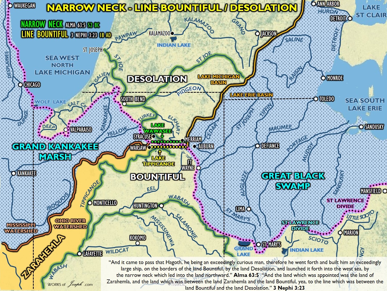
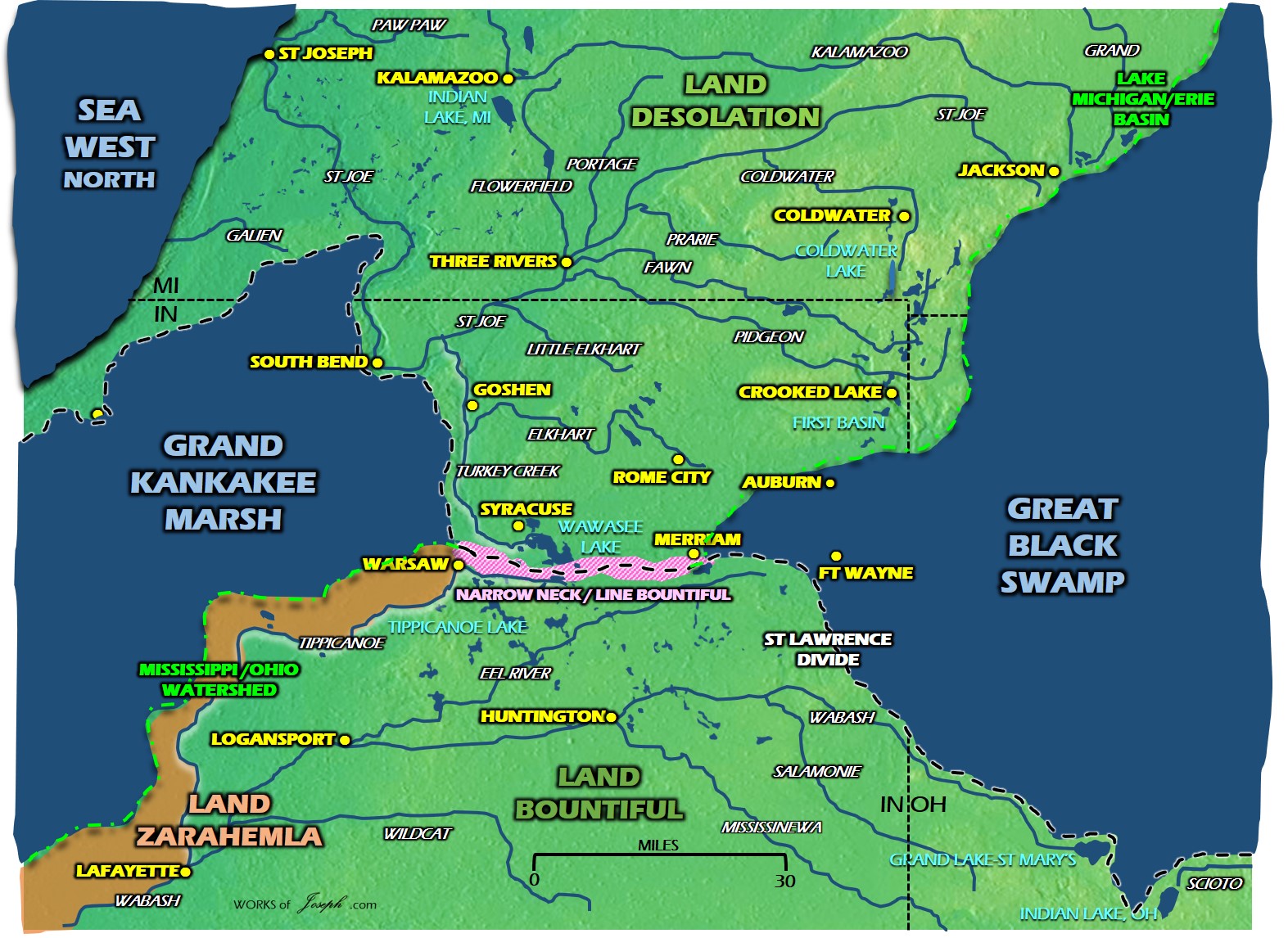
The NARROW NECK is very different than the “Narrow Neck of Land” I will share with you how the Narrow Neck in Alma is located in Indiana along the St Lawrence Divide which divides the land. The rivers flow north of the Narrow Neck towards the Gulf of St Lawrence or south towards the Gulf of Mexico- The Narrow Neck of Alma is where Hagoth built his ships. On Lake Michigan lower east side following Lake Michigan’s coast along the St Lawrence Continental Divide to the St. Joe River. Anciently the Grand Kankakee Marsh extended south of Lake Michigan and the Great Black Swamp extended west of Lake Erie. The neck running E/W was 30 miles between Warsaw, IN and Merriam IN. See Alma 63:5

Ancient Lake and Marsh
GRAND KANKAKEE MARSH Everglades of the North. 1 Million acres called “New France” and “Chicago’s Food Pantry.” An endless supply of fur, fowl, and fin. Information
GREAT BLACK SWAMP 40 miles wide and 120 miles long. It was the Great Black Swamp, an oozing mass of water, mud, snakes, wolves, wildcats, biting flies, and clouds of gnats and mosquitoes. Information
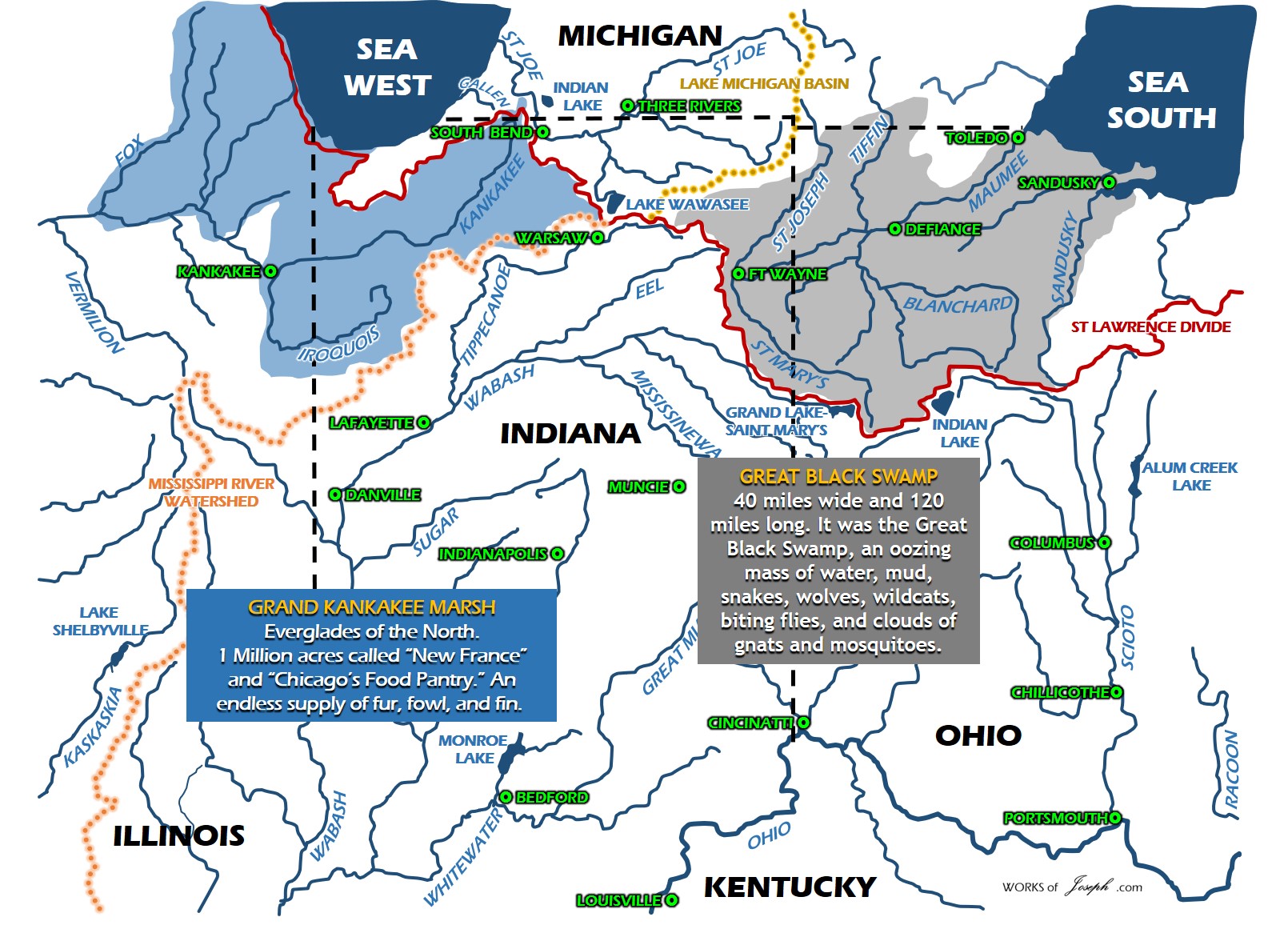
The Narrow Neck Alma 63:5 and the Line Bountiful 3 Nephi 3:23-24 are the same area.
“And it came to pass that Hagoth, he being an exceedingly curious man, therefore he went forth and built him an exceedingly large ship, on the borders of the land Bountiful, by the land Desolation, and launched it forth into the west sea, by the narrow neck which led into the land northward.” Alma 63:5
“And the land which was appointed was the land of Zarahemla, and the land which was between the land Zarahemla and the land Bountiful, yea, to the line which was between the land Bountiful and the land Desolation. And there were a great many thousand people who were called Nephites, who did gather themselves together in this land. Now Lachoneus did cause that they should gather themselves together in the land southward, because of the great curse which was upon the land northward.” 3 Nephi 3:23-24
These divides and basins determine which way the water flows and where the rivers begin. If I were a Nephite I would not cross the rivers, but I would travel on the rivers and follow the walking path of these divides and basins. A Nephite could walk all along the red or orange lines without ever crossing a river. Can you find the Narrow Neck yet?
The Saint Lawrence River Divide is a continental divide in central and eastern North America that separates the Great Lakes-St. Lawrence River Basin from the southerly Atlantic Ocean watersheds. Information Long Red Line above
Lake Erie Basin consists of Lake Erie and surrounding watersheds, which are typically named after the river, creek, or stream that provides drainage into the lake. The watersheds are located in the states of Indiana, Michigan, New York, Ohio, and Pennsylvania in the United States, and in the province of Ontario in Canada. Information Orange Line North of the St Lawrence Divide
The Michigan Basin is a geologic basin centered on the Lower Peninsula of the U.S. state of Michigan. The feature is represented by a nearly circular pattern of geologic sedimentary strata in the area with a nearly uniform structural dip toward the center of the peninsula. Information Orange Line North of the St Lawrence Divide
The Mississippi River Basin has the world’s fourth-largest drainage basin (“watershed” or “catchment”). The basin covers more than 1,245,000 square miles (3,220,000 km2), including all or parts of 32 U.S. states and two Canadian provinces. The drainage basin empties into the Gulf of Mexico, part of the Atlantic Ocean. Information Orange line south of the St Lawrence Divide
The Ohio’s drainage basin covers 189,422 square miles (490,600 km2), encompassing the easternmost regions of the Mississippi Basin. The Ohio drains parts of 14 states in four regions. Information Orange line south of the St Lawrence Divide
NARROW NECK– Where Hagoth built his ships. On Lake Michigan lower east side following Lake Michigan’s coast along the St Lawrence Continental Divide to the St. Joe River. Anciently the Grand Kankakee Marsh extended south of Lake Michigan and the Great Black Swamp extended west of Lake Erie. The neck running E/W was 30 miles between Warsaw, IN and Merriam IN. Alma 63:5
Pink line above is also the LINE DESOLATION/BOUNTIFUL- The Great Black Swamp anciently went from the west end of Lake Erie to Fort Wayne, Indiana. It occupied what was formerly the southwestern part of proglacial Lake Maumee, a Holocene precursor to Lake Erie. Grand Kankakee Marsh anciently surrounded the south of Lake Michigan. These swamps almost connected W/E along the St Lawrence Divide. The northern Lake Michigan water basin and the southern Mississippi water basin create a line along the St Lawrence Divide of about 30 miles. From about Warsaw, IN to Auburn, IN, is the 30 mile long E/W line the Nephites would have to of defended. 3 Nephi 3:23
This is a close up of the Line Bountiful/Narrow Neck in the large yellow dots. This would be a route the Nephites could have walked. Remember the rivers and water flow north or south of this yellow like as it is the St Lawrence Divide and the highest point of this region.

Look at all of the arrows so you can see what direction each river is flowing. They can flow any direction including north like parts of the Tennessee River and the New River. Notice the Plains of the Nephites goes West and East through Ohio, Indiana, and Illinois.
Notice Ancient Lake Tight? Lake Tight, named for geologist William G. Tight, was a glacial lake in what is present-day Ohio, Kentucky, and West Virginia, during the Ice Age the early Pleistocene before 700 ka. As you know I think most geologists have their dates wrong. Lake Tight could have been around during the Jaredite times. Also look at Lake Erigan an Ancient Lake system. Prior to the beginning of the Pleistocene Ice Age about two million years ago, Ohio’s drainage system consisted of at least two major river systems. Best known is the Teays system that entered southern Ohio and swung westward across Indiana and Illinois to the ancestral Mississippi River system. The Teays River (pronounced taze) was a major preglacial river that drained much of the present Ohio River watershed, but took a more northerly downstream course. Again the dates are probably wrong but it is nice to see the geology of the ancient United States. It may have been Jaredite or Nephite times as we just don’t know.
The Nephites really were nearly surrounded by water. See the map below.

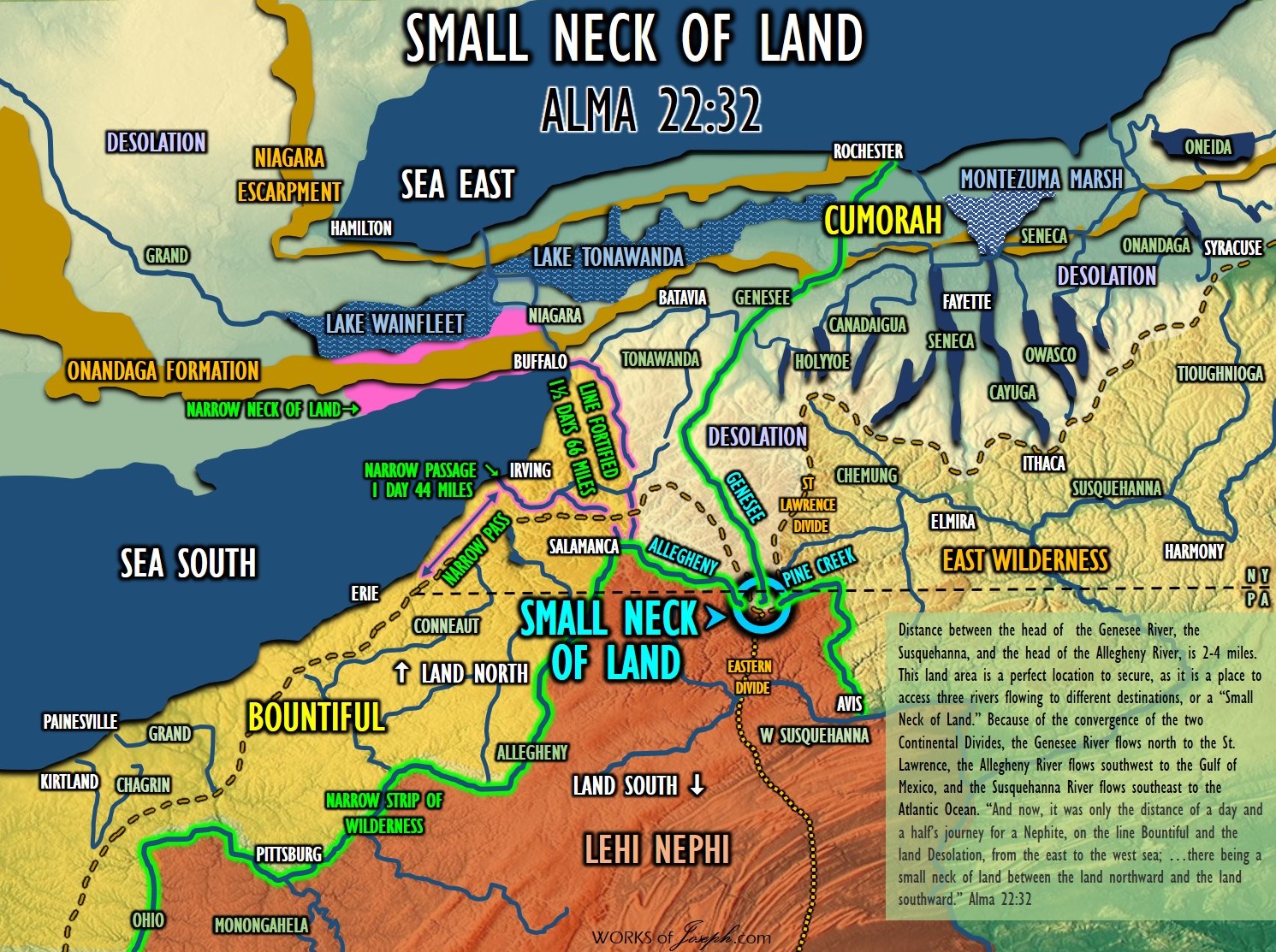
The above map references the third neck we haven’t spoken of much yet. The “Small Neck of Land” is at Gold, PA which is a place called a Triple Gap, which is part of the Eastern Continental Divide.
The Eastern Continental Divide, Eastern Divide or Appalachian Divide is a hydrographic divide in eastern North America that separates the easterly Atlantic Seaboard watershed from the westerly Gulf of Mexico watershed. The divide nearly spans the United States from south of Lake Ontario through the Florida peninsula, and consists of raised terrain including the Appalachian Mountains to the north, the southern Piedmont Plateau and lowland ridges in the Atlantic Coastal Plain to the south. also see the map below which shows #3 as the Small Neck of Land which connects to the St. Lawrence Divide and goes south past Atlanta where #11 is probably where Nephi traveled north to get away from his brothers.
Walk through this map colors to determine where each divide, land, or neck is located. If you learn to read the maps you will definitely know how and why the Nephites traveled the way they did. The highways of the Nephites were the rivers.
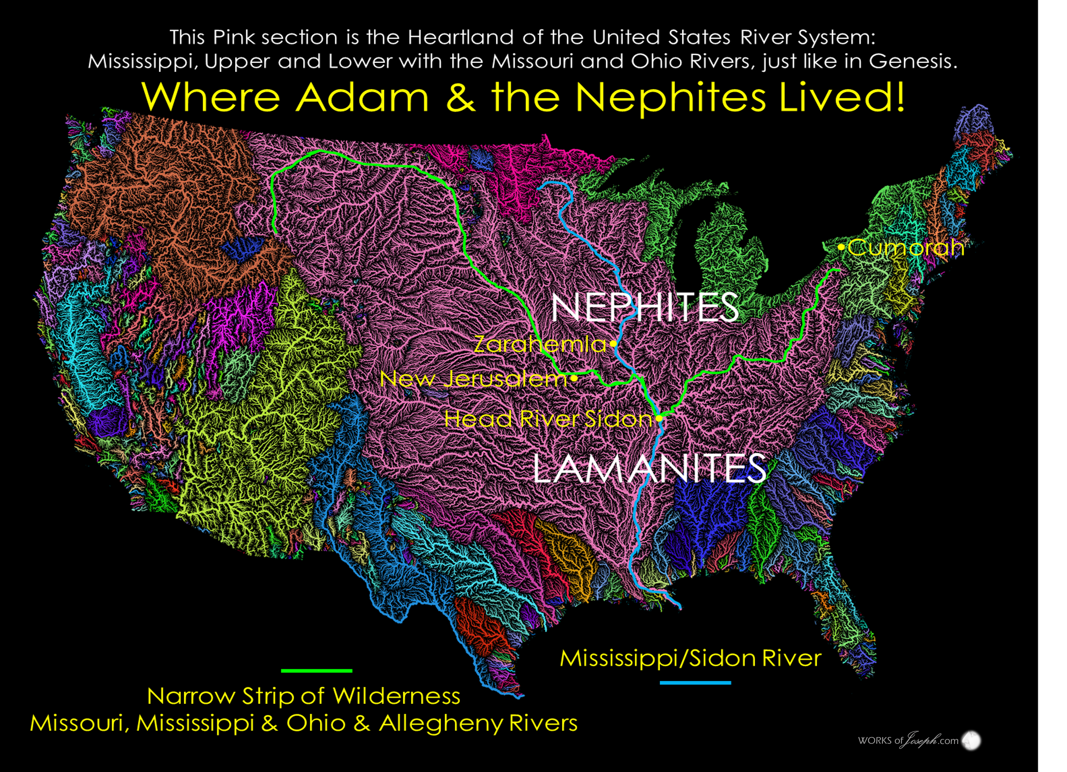
In this large map you can see all the river systems in the United States. See the large Mississippi river system in pink right through the middle of the U.S. It is one of the most productive systems in the world. No wonder the Lord chose it for the Promised Land. Dr. John Lefgren PhD, has done a lot of research in determining how valuable this Mississippi Valley was to feed the people and armies of the Nephites below.
Conflict and Displacement of Hopewellian People In the 4th Century in Western New York
Focus of Research in the Heartland of North America- Prepared by Dr. John Lefgren PhD Complete Blog Here

“All serious conflict results in the displacement of people. Indeed, much of the movement of people in the ancient as well as the modern world is the result of conflict. The proposed research would examine the movements and the encampments of the Hopewellian people who were in conflict in Western New York during the late 4th century. The paper examines associated themes such as the dislocation and displacement of people who came from the river valleys of Ohio and Illinois. There would be a review of the accounts by the first Europeans of fortifications and artifacts of war including bones of a people who were in Western New York a thousand years before Columbus. The research would examine sites where the archaeological record shows artifacts from the rich agricultural lands of the Mississippi river valleys. The research would examine various aspects of ancient life in these sites and their particular ‘wilderness’ settings, framing the discussion within the themes of movements and dislocations, and especially their multiple impacts on the Hopewellian people who came to a land removed from their origins. A particular emphasis for the research would be movements and dislocations of people in conflict. The Hopewellian people became in effect ‘stuck’ in the northeastern wilderness. The inhabitants of these ancient sites were in conflict and they coped with the situation as well as they could. The conflict is reflected in the different features of the sites and the archaeological material which the fieldwork produces. The research would focus on how conflict pushed the Hopewellian people from one region to another. The research will compare the multi-generational construction of large and numerous earthworks of these people in Ohio to the immediate construction of hundreds of fortifications in Western New York. Considering the displacement of people in our time the research will note how conflicts have pushed hundreds of millions of people from one region to another in Europe, Africa, the Middle East, the Indian Subcontinent and Asia. In this context the research examines how in the ancient world one conflict pushed one people from the Heartland of America into the northeastern lands of Western New York.” Lands, Peoples, and Armies In Ancient America During the Fourth Century John C. Lefgren, PhD
Statement of Dr. Lefgren’s Thesis
This paper supports the Heartland Geography for the lands of the Book of Mormon. The primary arguments are based on the knowledge (1) that large armies need large populations, (2) that large populations need large amounts of food, and (3) that large amounts of food need large amounts of land and water. The historic setting for the Book of Mormon is a place which is epic in size and significant in location. Moroni confirmed the grandeur of his people. Moroni’s father, Mormon, was the leader of armies which were larger than those under the command of George Washington. The armies of Mormon operated in areas which were comparable to those of Ulysses S. Grant and Robert E. Lee. The history of this true story entails 1,500,000 square miles where the waters of the Mississippi and St. Lawrence flow.
Mormon wrote in AD 385 that he had under his command 230,000 men. He placed his armies in defensive positions because his armies were numerically less than his opposition. In the final battles, the two sides had more than 500,000 combatants. This war required huge amounts of material and food. The methods of production were pre-industrial. In the final stages of the war the combatants needed more than 1,000,000 tons of food and supplies per year. How did these nations organize themselves? Does pre-modern history in other parts of the world help us to understand what Mormon experienced? These are the important questions of this paper.
The conclusion of the study is that in the final battles of the late fourth century the Lamanite armies had access to the resources of the world’s largest contiguous arable land while the Nephite armies had access to the resources of the world’s largest system of fresh water lakes. The Mississippi Basin has an area of about 1,000,000 square miles and the St. Lawrence Basin has an area of about 500,000 square miles. The study explains that the theory of war for a large theater of operation gave good reasons why Mormon would gather the Nephite armies into defensive positions near the southern shores of Lake Ontario.
The final battles of the Book of Mormon required the resources of the basins of the Mississippi River and the St. Lawrence River. In the battle of AD 385 there were combatants who came from the 31 states which are connected to the Mississippi as well as from the 9 states and 6 provinces which are connected to the St. Lawrence. The armies of the Lamanites destroyed the armies of the Nephites. The final battles required more than 1,000,000 tons of food and material which were produced by a population of about 30,000,000 who were working in an area of 1,500,000 square miles. The men and material necessary to execute this war were moved on the major waterways of North America.
Given available historical sources, it is possible to estimate how lands, waterways, people and armies were interrelated in the pre-modern societies of Europe and Asia. These interrelationships help to establish how similar parameters related to people who were preparing for battle in North America in AD 380.

Christ in America- 44-page PDF Thirty-eight years after the publication of his first book, Dr. Lefgren again looks to the Mosaic Law for the ordering of days and how this calendar connects to the birth of Christ as synchronized by the world’s largest geometric clock. He examines the very minute for the numeric harmony of the sign for the birth of Christ — a sign which ancient people witnessed in the Heartland of America. The identification of this moment is found in a timeline from more than 2000 years ago and relies on 6 primary sources: (1) the exact movements of the earth around its axis; (2) the exact movements of the earth around the sun; (3) the exact movements of the moon around the earth; (4) the exact physical alignment of 3,000 acres of ancient earthworks in Newark, Ohio; (5) the exact 5-year prophecy of the coming of Christ by Samuel, the Lamanite; and (6) the exact eyewitness testimony of the fulfillment of the prophecy by Nephi, the Son of Nephi. All these sources point to the same moment in time and place.

He has a new book here which is entitled The Sign Before the Birth of Jesus Christ; As Witnessed in Newark, Ohio, 6:29 P.M., Tuesday April 6th, 1 B.C.; The 5-Year Prophecy of Samuel, the Lamanite; The Sun and the Moon Keeping Ancient Time at the Newark Earthworks.
Dr. Lefgren along with Dr. John Pratt have created a wonderful new DVD called, “Oh How Lovely was the Morning” This is the true story about two people who were on the same search for important dates associated with the History of the Church. Little did they know that their paths would come together many years later in such an important way. The event of the First Vision and the appearance of the Father and the Son to the Prophet Joseph Smith, stands alone as the pivotal event from the Lord in these last days! John Lefgren and John Pratt conclude the date of The First Vision was March 26, 1820.
UNDERSTANDING NECKS, LINES, PASSAGES, STRIPS, AND THE NARROW NECK OF LAND
NARROW PASS- This could be described in many areas in the Heartland of America, as the geography has changed over the years. We know the Great Lakes have receded since ancient times. Passes could include: The land pass between Lake St. Clair and Lake Huron (St. Clair River), or Land between Lake St Clair and Lake Erie. (Detroit River), or E-W pass between Lake Erie and Lake Ontario near Niagara Falls. The best choice is the land E-W between the south side of Lake Erie and the Allegheny River, from Irving, NY to Salamanca, NY. Lake Erie was larger anciently and is bordered on the south by the St Lawrence Divide.Mormon 3:5 (Near Buffalo, NY by the Narrow Neck of Land)
Alma 50:34. (Line Desolation between Lake Erie and the Allegheny River.) Alma 52:9 (Line Bountiful is an E/W Continental Divide of 30 miles between Warsaw, IN, and Auburn, IN.
NARROW PASSAGE- Begins on the south side of Lake Erie at Irving NY, following the Cattaraugus Creek south through Zoar Valley on the Little Valley Creek, ending at the Allegheny River which is where the land southward begins. A day’s journey for a Nephite of 44 miles. “On the south side of Lake Erie, there is a series of old fortifications, running from the Cattaraugus creek to the Pennsylvania line, a distance of fifty miles; some are two, three, and four miles apart, and some within half a mile.” Clinton, De Witt. A Memoir On The Antiquities Of The Western Parts Of The State Of New-York. Mormon 2:29
NARROW NECK- Where Hagoth built his ships. On Lake Michigan lower east side following Lake Michigan’s coast along the St Lawrence Continental Divide to the St. Joe River. Anciently the Grand Kankakee Marsh extended south of Lake Michigan and the Great Black Swamp extended west of Lake Erie. The neck running E/W was 30 miles between Warsaw, IN and Merriam IN. Alma 63:5
NARROW NECK OF LAND- Lake Ontario divides the land at Hamilton, OT Canada, and Lake Erie divides the land at Buffalo, NY, and at Toledo, OH. In Central America the ”land divides the sea”. (Isthmus of Tehuantepec) Lake Ontario and Lake Erie are seas, where the “sea divides the land” as quoted in Ether. Ether 10:20. The N/S distance from Lake Erie to Lake Ontario is only about 24 miles wide.
SMALL NECK OF LAND- Allegheny, Susquehanna, and Genesee head-river gaps. (Triple Divide) Only 6 miles between each of these three river heads, where the two Continental Divides meet. (St Lawrence and Eastern Divide) Anciently this location was called the Forbidden Path, and was a strategic defensive location, hunting area, and buffer zone for the Native Americans to protect their south land. “Leading directly into the heart of the central New York Iroquois heartland, the Forbidden Path stood at a strategic transportation break linking river systems ultimately flowing into Chesapeake Bay, the Great Lakes, and the Ohio Valley.” (Journey on the Forbidden Path: Volume 89, Part 2 By Christian Frederick Post, John Hays) Alma 22:32. This is the gate of the Narrow Strip of Wilderness and the place which is the “Nearly” in “nearly surrounded by water.” Don’t confuse this location with the more well known, “Narrow Neck of Land.” (3 “NECKS” see # 3,4,5).
NARROW STRIP OF WILDERNESS- The Allegheny, Ohio, Mississippi, and Missouri Rivers act as a west to east fence, across the United States. This is the main border between the Nephites and Lamanites from about Independence MO to Hill Cumorah . The gate of the fence is the Small Neck of Land which is why the Nephites and Lamanites were “nearly” surrounded by water. Alma 22:27. Rivers are well known as a type of wilderness where there are marshes, weeds, and unusable space along both banks of rivers, thus creating a wilderness area where people don’t live, especially if the river bed is low or dry.
LINE BETWEEN/LINE FORTIFIED- Journey for a Nephite from the “Great City” at Buffalo, NY in a straight line to the Allegheny River near Salamanca, NY. Remember everything south of the Allegheny River is the land southward. (66 miles or about a day and a half for a Nephite). North of this line is Desolation and south is the Land Bountiful.
Line Fortified Helaman 4:7 Line Between Alma 50:11
LINE DESOLATION/BOUNTIFUL- The Great Black Swamp anciently went from the west end of Lake Erie to Fort Wayne, Indiana. It occupied what was formerly the southwestern part of proglacial Lake Maumee, a Holocene precursor to Lake Erie. Grand Kankakee Marsh anciently surrounded the south of Lake Michigan. These swamps almost connected W/E along the St Lawrence Divide. The northern Lake Michigan water basin and the southern Mississippi water basin create a line along the St Lawrence Divide of about 30 miles. From about Warsaw, IN to Auburn, IN, is the 30 mile long E/W line the Nephites would have to of defended. 3 Nephi 3:23
Visit or look online at the many Mounds the Jaredites and Nephites were most likely living near, in Indiana and by the the Narrow Neck. Free Maps Here:
[…] This quote above could have been in reference to the many battles fought between the Lamanites and Nephites in this general area. (See Map Below) The area described in the article above is the area we would call the middle of the Land Zarahemla and the Land Bountiful with the Land Desolation being north of Bountiful. As a matter of fact, my maps show that the Wabash River could possibly be the division point of the Land Bountiful, east of the Wabash, and the Land Zarahemla west of the Wabash to the Mississippi River and beyond, to the Missouri River. The area of Lachoneus of the Book of Mormon and many other battles in Alma 2 and Alma 46 are probably likely just south of the Narrow Neck bordering on the land Zarahemla and the Land Bountiful on the Wabash River. That area of Missouri to Illinois, to Indiana to Ohio to Pennsylvania were all the direction of the last great battle of the Book of Mormon ending at Cumorah. Full Blog Here: […]
Comments are closed.