In the Heartland of the United States you will find many interesting geological features that help you create a map about ancient dwellings of the Book of Mormon people.
Each map I share with you will teach you incredible information of the plausible travel and routes of the Nephites and Lamanites. Where they could have traveled and where there was an impossible obstacle that could not be overcome. All of these things affect the time and mode and way of travel.
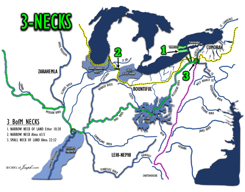
Bookmark this blog for future reference. There is an overload of information that was put together not just to read in one sitting, but refer to over and over. You won’t know and understand Nephite Geography or Geology without a broad rage of study. In fact, take just one section for example, “The Narrow Neck” and study it completely. Begin in Alma 63:5 which was in 52 BC. Read other blogs and see questions and answers on our site here: https://bookofmormonevidence.org/answers/ or call Rian or email me at [email protected] and I will be happy to help. IE, see blog here: https://bookofmormonevidence.org/understanding-necks-lines-passages-strips-and-the-narrow-neck-of-land-2/
Where Did the Nephites Live
Jungles of Mesoamerica, or the Plains of the United States? The promised land of America or a land somewhere else that may be nice, but it was not chosen as the Promised Land? “The United States is the promised land foretold in the Book of Mormon—a place where divine guidance directed inspired men to create the conditions necessary for the Restoration of the gospel of Jesus Christ.” Elder L. Tom Perry Ensign Dec. 2012
Where would they have lived and why and what archaeology may validate it? What would be the best places of defense or where to build a fort. How important to have high places where you could see your enemy? What method of transportation would be best, walking or canoe? Where to build a city and live for long periods because of the nearby farms or type of soil?
Considering the Heartland of the United States has changed over the years, how would those changes affect the Nephites. In other words what terrain or lake is not present today that could have been there many years ago? How could those changes effect where the Nephites lived or fought?
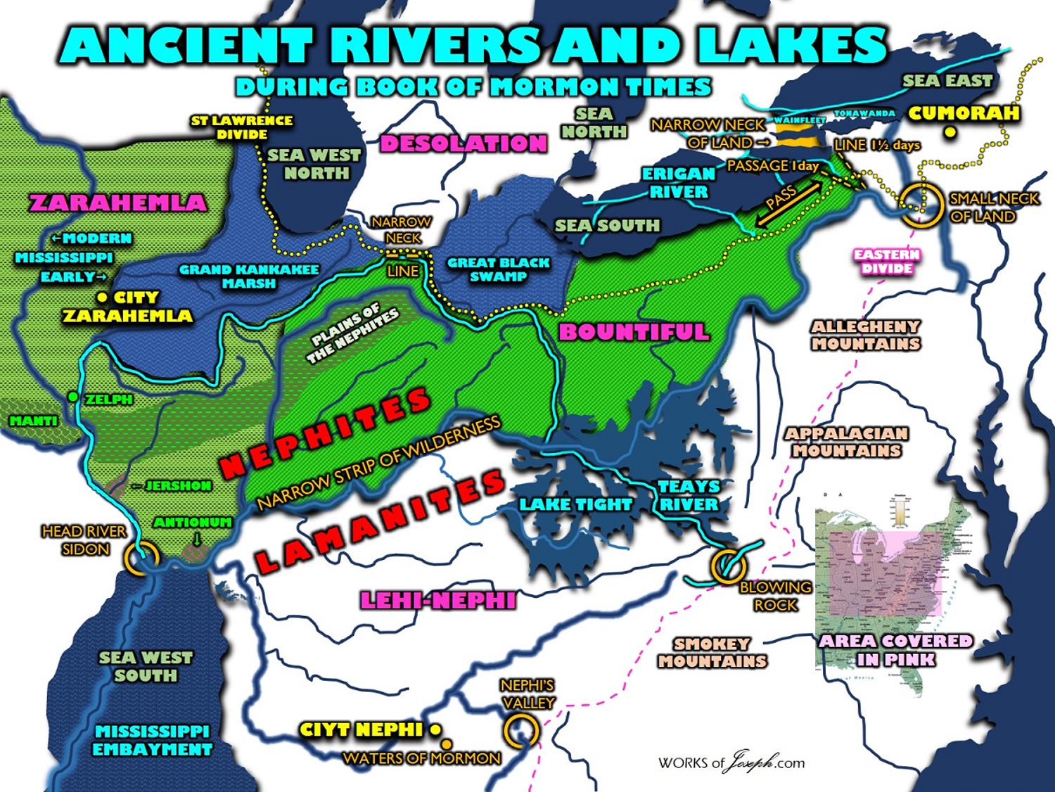
My purpose in this blog is to let you know about ancient lakes, rivers, terrain, artifacts, swamps, fortifications, marshes, and climate that would have a major impact on where the Nephites lived and defended their territory. What geological features are not present today in the Heartland that were very important to the survival of the Hopewell Culture or as we would call it the Nephite Culture?
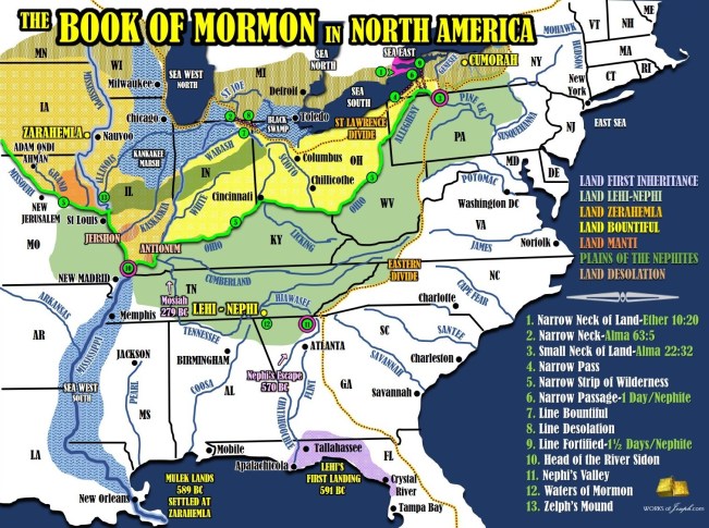
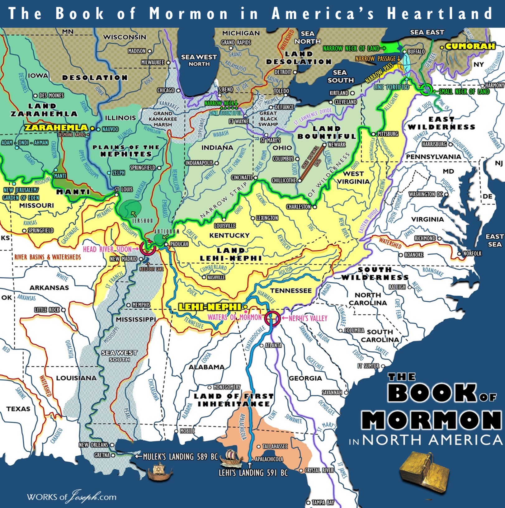
Below is the overall main map of the entire Nephite territory!
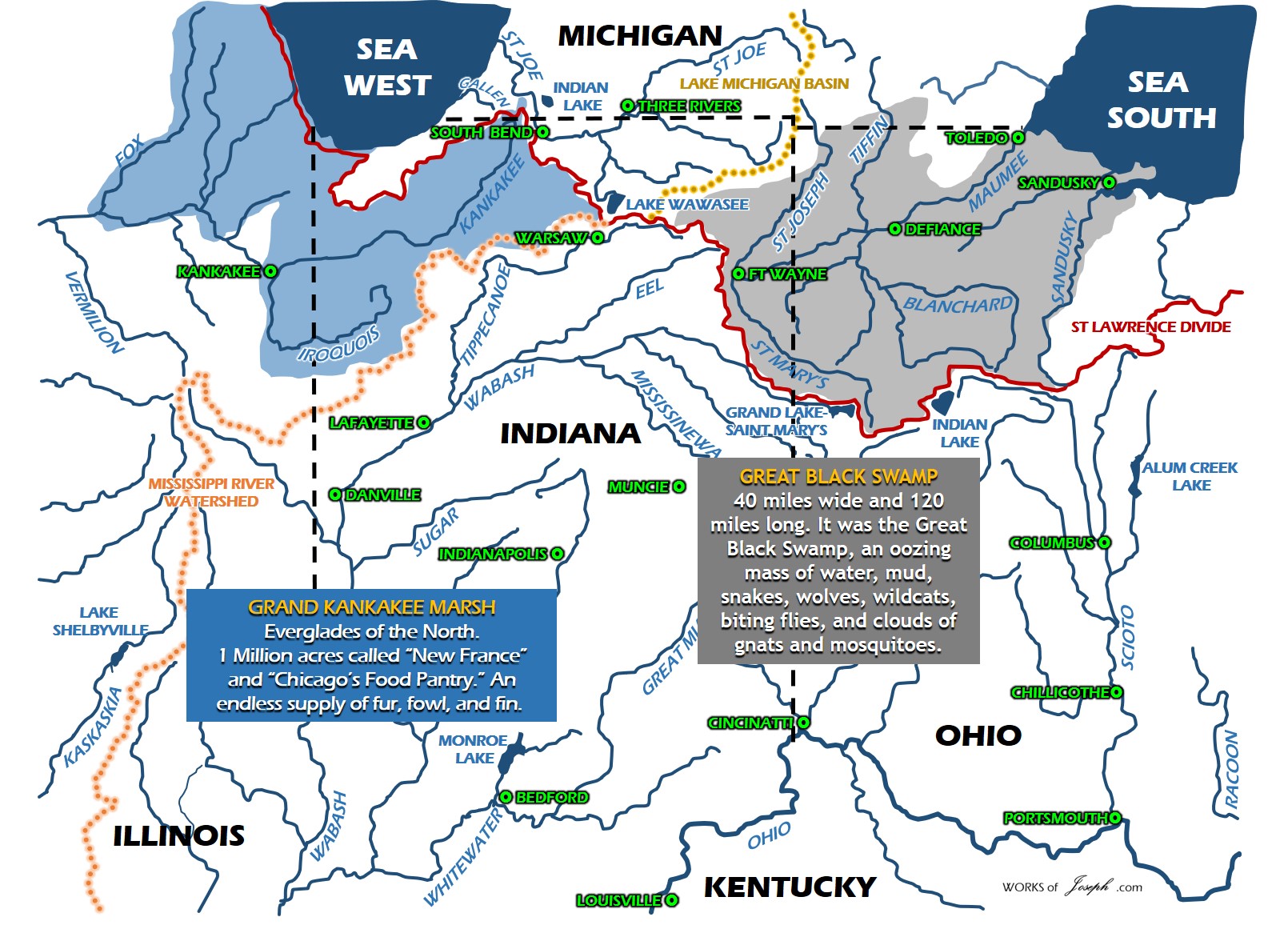
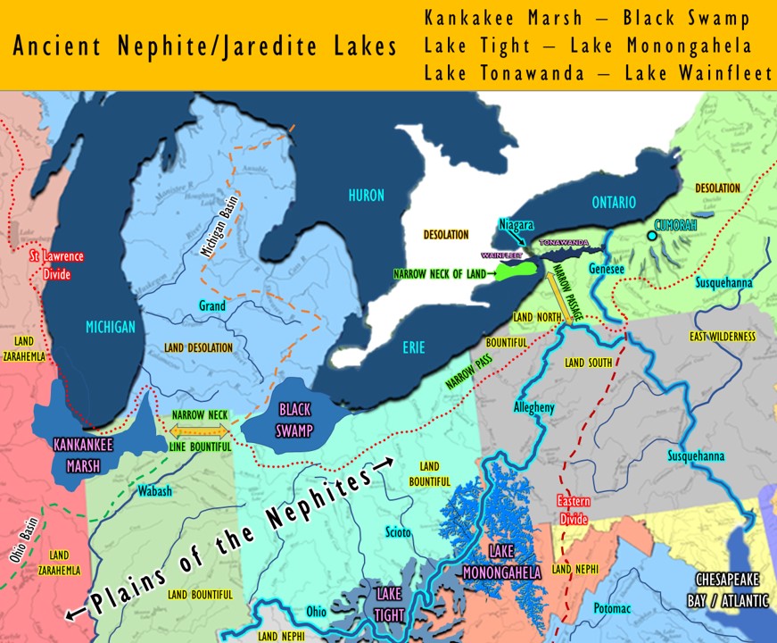
Great Black Swamp
“It is hard to believe that there once lay a terrible swamp beginning in the vicinity of South Boundary Street and running as far south as Findlay, Ohio, and east and west from the city of Sandusky nearly to Fort Wayne, Indiana…40 miles wide and 120 miles long. It was the Great Black Swamp, an oozing mass of water, mud, snakes, wolves, wildcats, biting flies, and clouds of gnats and mosquitoes. It was nearly big enough to cover the entire state of Connecticut. (Map Below)
Water, often up to the belly of a horse, stood on the surface until it evaporated in the hot summer months. When it rained, or thawed in the winter, it was water and muck. Much of the swamp was covered with an almost impenetrable forest of giant oak, sycamore, hickory, walnut, ash, elm, maple and cottonwood trees, except in a few prairie areas where limestone just under the surface would not support timber growth.
Not even native Indians went into the swamp except to hunt, and unless you could follow a blazed trail, it was easy to become hopelessly lost since you could only see but a few yards ahead.
The enormous weight of the mile-thick ice pack pressed down and scooped out the earth beneath it to create a depression about 10 feet lower south of where Perrysburg sits on the river bluff. Thereafter, until it was drained, water stood in the silted wetland and clay in the ground prevented it from soaking in. When water was standing and flooding conditions occurred, large fish from the Maumee River and other streams could swim all over areas now covered by corn and soybean fields. One man in Perrysburg told of ice skating all the way to what is now Weston, Ohio, nearly 17 miles southwest of Perrysburg.
There was no end to the variety of sickness and maladies spawned from the mosquito-infested swamp. There was cholera, typhoid and milk sickness, but chief among them were malarial fevers generally known as “ague” for which people kept quinine powder on the table, along with salt and pepper, to sprinkle on their food. (See Alma 46:40)
The fevers caused people to have chills, or the shakes, and according to a doctor of the time it took them from three to five years to get over it. The shakes occurred from about the first of July until the first frost. They took hold of people and literally shook them up. The doctor wrote that so violent were the chills and shaking that when they came on, the very bed and floor would rattle.
The Black Swamp was Ohio’s last frontier, and beginning in the 1840s, it took several generations of determined farmers to drain it and make it the rich, flat farmland of today. What started it all was pretty much the idea of the medical profession which believed that it was bad swamp air that caused the fevers.
They were ignorant of the fact that it was blood-sucking mosquitoes that transmitted the disease, but at least they were on the right track. Along with this, when canals and railroads came through here they created markets for the vast timber resources, most of it in the swamp. And still another good reason for beginning the tremendous job of draining the swamp was the realization that it could be done. People learned from trying to build roads that they could dig ditches and the water would flow toward the nearest stream of river.
Until then, early farmers tilled just the highest ground, with some effort to build shallow, open ditches around a plot or field, or one leading to the nearest creek if available. As more settlers came, farmers would sometime cooperate in extending their adjoining ditches.
Finally, in 1850, the Ohio legislature passed the first law regarding government support for drainage systems resulting in people throughout Northwest Ohio cooperating in wide-area drainage, with ditches deep enough to drain the swamp water into Lake Erie via the Maumee and Portage Rivers.
Individual farmers continued to dry out their fields by plowing trenches across them, using wooden troughs laid underground, and eventually with clay tiles and pipe introduced by European farmers.
It took back-breaking labor and construction of one of the greatest underground drainage systems in the history of the world to create the productive farmland we now drive by and take for granted just outside of Perrysburg.” Historic Perrysburg Inc 2006-2012

Great Black Swamp Book of Mormon Features-
Narrow Neck
Line Bountiful/Desolation

Great Kankakee Marsh Book of Mormon Features-
Narrow Neck
Line Bountiful/Desolation
Hagoth’s Launch
Grand Kankakee Marsh
”Located along the historic Kankakee River, the park is dynamically affected by seasonal flooding. This, along with different natural communities, provides ideal feeding in the fields for a variety of wildlife. Densely wooded areas and the remnants of old river channels provide excellent habitat for a large deer herd, many species of ducks, and other wildlife. Preservation of these natural habitats is one of the primary goals of the Lake County Parks and Recreation Department.
Hunting, wildlife and bird viewing, biking, hayride tours and canoe workshops make up the majority of recreation opportunities at the Marsh. The levees are also heavily used as bridle trails. GKM, along with Stoney Run and Deep River, are the Lake County Parks where the public may ride their horses. For the past 19 years, the park has been the site of the annual Voyageur Rendezvous, a living history reenactment of the early French fur trade era that presents educational information in a colorful re-creation.
GKM was acquired in 1977 with assistance from the Nature Conservancy. Through the years the marsh has been developed and managed for wildlife as well as public use. The careful management and regulation of hunting seasons has helped to make this property a noteworthy hunting area.
The majority of the park land was acquired through grants. In 1977 $425,000 was provided by the Land and Water Conservation Fund for the purchase of 872 acres. Since then many other grants, donations, and purchases have been combined to increase the park site to 2,069 acres.
In 1991, the park department received an Indiana Waters Grant of $250,000 (Dingle/Johnson Funds) to construct public access site on Kankakee River at Grand Kankakee Marsh. Special design included floating finger pier that “rides” with the 12′ high and low levels of the river. Parking for ten cars with trailers adjoins handicapped accessible ramp.
Summary
The Grand Kankakee Marsh that bordered the Kankakee River once consisted of between 500,000 and 600,000 acres of marsh land in Indiana.
It was from two to fifteen miles wide for the length of the river in Indiana and was the largest contiguous marsh in Indiana and one of the largest on the continent.
To understand how such a magnificent Marsh could be obliterated, one must consider the prevailing sentiment in the country at the time. The push was one to settle the area and then stake claim to the land further West. Settlement, at the time, meant agriculture.
Portions of the Kankakee Marsh soil were a black, sandy loam, three to six feet deep. This was potential prime farm land, all that needed to be done was to remove the water. Once the actual draining process began and well connected land speculators became involved, the drainage project became unstoppable. The voices of those who objected to the project could not be heard over the din of the activities of the steam shovels.” Lake County Parks and Recreation Department Corporate Office 
Lake Tight
A GREAT LOST RIVER GETS ITS DUE By WALTER SULLIVAN
NY Times Published: November 29, 1983
GEOLOGISTS now believe that one of the great master rivers of world history once flowed west from the eastern portion of the United States and was responsible for much of the land and stream formation as far west as the Mississippi valley. 
Its deep gorges and broad valleys, as well as remnants of its many tributaries, now lie hidden under glacial deposits covering the region south of the Great Lakes.
Not until recently has the existence of such a river – probably formed more than two million years ago and almost certainly never seen by human eyes – finally become accepted.
Yet early explorers of the Ohio River drainage basin did begin to note early on that there was something very mysterious about its topography.
In 1838 a Dr. P. Hildreth wrote, in the first annual report of the Geological Survey of Ohio, ”Great changes have evidently been made in the direction of all our watercourses before they found their present levels.”
Typical of the evidence for such changes was the observation by Gerard Fowke in 1886 that the deep gorge west of Chillicothe, Ohio, could not have been formed by the trickles of Paint Creek, its present occupant. It must, he said, have been cut by a mighty river. His proposition, however, was met with great disdain by the conventional geologists of the time.
In 1903 William G. Tight of Denison University in Granville, Ohio, made a similar observation in West Virginia: The deep valley running westward from Charleston to the Ohio River, he said, carries no significant flow of water beyond St. Albans, where the Kanawha River suddenly turns north. Professor Tight sought in vain to persuade the geological community that this valley once carried a mighty river that continued across Ohio, Indiana and Illinois through a valley now deeply buried under glacial deposits. He called it the Teays (pronounced taze) River, for a village in West Virginia.
Mahomet Valley
After its discovery by coal explorers, the hidden river valley across Illinois was called the Mahomet Valley, for a town where the river is most deeply buried. But geologists did not then regard it as a continuation of the Teays, as most of them now do. 
Some rivers, such as the Scioto in Ohio, have completely reversed their ancient direction of flow. The Scioto now flows south over a deep bed of glacial material, past Columbus and Chillicothe, to the Ohio River at Portsmouth. The bedrock beneath it, however, shows that it once formed a section of the Teays where it flowed north.
A key factor in changing direction was the formation of a ”forebulge’‘ in front of the advancing ice, produced in much the same way as marshy ground bulges forward when one walks across it.
Earlier this year a conference was held at the Newark campus of Ohio State University to discuss the role of the Teays River valley in providing migration paths for southern plant life into Ohio. Isolated groves of magnolias grow wild along the old riverbed, as do some species of azalea and rhododendron.
A related mystery of long standing is the presence of enormous boulders of alien origin in parts of Kentucky, far south of the known limits of ice advance.
The boulders seem more typical of rocks from the Adirondacks or the region between Ottawa and Quebec. The Epworth Boulder in Lewis County, Ky., weighs 16 tons.
It seems clear that they must have been carried south by ice, yet there are no other glacial deposits in the area. One possibility is that they were left by a very early glaciation.
Teays River or Ohio River
Still the notion of such a river remained unpopular, but over the years it has been slowly rolling along toward acceptability. Now, as was manifest at last month’s meeting of the Geological Society of America in Indianapolis, scientists believe the evidence is overwhelming. One entire session of the conference was devoted to tracing the course and complex history of this ”new” American river – the Teays. 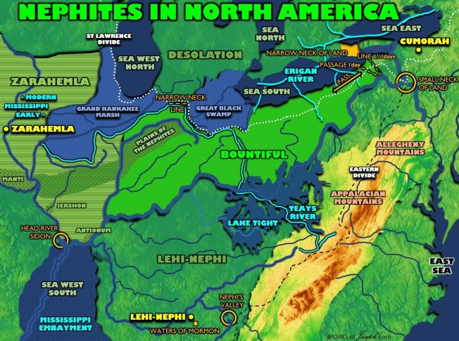
The buried river and its surrounding landscape have now been charted by recording the depths to bedrock of tens of thousands of water, oil and gas wells. This procedure has revealed the location of most of the main stream and its tributaries, but there are still gaps.
Near Springfield, Ohio, for example, one of the buried tributaries seems to stop at a wall of stone. No route around the wall has yet been found. Various improbable explanations have been advanced, Dr. Richard P. Goldthwait of Ohio State University points out, such as, for example, a passage through extensive underground caverns.
An early clue to the Teays route across Illinois was uncovered in the 1880’s, when a coal company sank an exploratory shaft on the edge of Urbana. At a depth of 125 feet, water began pouring into the excavation at such a stupendous rate that the company soon renamed itself the Union Water Supply Company.
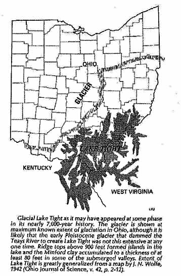
What finally killed the Teays River and gave birth to the Ohio River were the repeated southward advances of mile-thick ice sheets. For a time the ice dammed the Teays, forming what geologists now call Lake Tight, whose silty deposits cover much of Ohio.
After the ice reached its southern limit and began retreating, it unloaded its burden of rock, gravel, sand, clay and silt, leaving the landscape, including the Teays valley, buried under hundreds of feet of glacial ”drift.”
Torrents of water from the melting ice formed the Ohio River along what had been the ice’s farthest southward advance.
Today, wells in that area provide two dozen public and industrial water systems with 50 million gallons of water daily, and the Indianapolis conference was told there is no evidence of severe depletion. In a sense the river is still there, though it no longer flows in one long continuous stream. It is believed that much of the water in the ancient bed of the Teays comes from regional rainfall that drains down into the aquifer, rather than from its original tributaries to the east. The wells penetrate as much as 300 feet of glacial drift that fills the valleys where the buried river joined an earlier course of the Mississippi.
Teays River 
Abstract
The Teays River was a preglacial river which drained a large portion of the east-central United States. The river met its end when Pre-Illinoisan (Early Pleistocene) ice sheets dammed the region, causing the formation of a large glacial lake, resulting in breached drainage divides and the formation of new drainage channels. These changes would eventually result in the creation of the modern Ohio River drainage system.
Geographic Setting
The Teays River was a preglacial river, comparable in size to its eventual successor, the Ohio River. The Teays River drained a large portion of the east-central U.S., including almost two thirds of Ohio (Hansen, 1995). The River’s headwaters were located near Blowing Rock, North Carolina and subsequently flowed through Virginia, West Virginia, Ohio, Indiana and Illinois. (Hansen, 1995).
Old Kentucky River
The largest tributary to the Teays River was the Old Kentucky River (Teller 1991), which extended from southern Kentucky through Frankfort (where I currently reside), and subsequently flowed northeast, meeting other tributaries and eventually joining the Teays.
In Virginia and West Virginia, the Teays River flowed in the valleys of the modern New River and Kanawha River (Hansen, 1995). The river then flowed west to Scioto County, Ohio and to Ross County, Ohio near Chillicothe. The valley then disappears under glacial sediments but can be tracked using water well yields and other means (Hansen, 1995). A total of seven tills have been identified within the Teays River Valley (Andrews, 2004). In portions of Ohio, the buried valley is up to 2 miles wide and lies beneath 500 FT of glacial sediments (Hansen, 1995).
Figure 2. Google Earth image showing remnant of Teays River Valley in Southern Ohio (N-S oriented river is the present day Scioto River).
Teays River Origins
The origin of the Teays River is up for debate. Some believe that the Teays formed during the Tertiary (Hansen, 1995). This scenario dates the formation of the Teays to approximately five million years ago, when water flowing from the Appalachian Mountain region carved channels while flowing to lower elevations (Ohio Department of Natural Resources). Another possibility is that the westward flowing Teays was a result of even earlier Pleistocene glaciations (Figure 3), which rerouted an earlier drainage system flowing to the Great Lakes region (Gray, 1991; Andrews 2004; Dutch 1999).
Glaciation and the Teays River
Pre-Illinoisan (Early Pleistocene) glaciations brought an end to the Teays River (Hansen, 1987), although specific dates were poorly constrained prior to recent cosmogenic isotope dating of fluvial deposits (Andrews, 2004). Dating of sediments suggests that the glacial advance which blocked the Teays did so sometime between 1.3 and .78 million years ago (Andrews, 2004).
The advance of ice sheets eventually dammed the Teays resulting in the formation of glacial Lake Tight, which is named after William George Tight, professor of geology and botany at Denison University. Tight published an article entitled “Drainage modifications in south-eastern Ohio and adjacent parts of West Virginia and Kentucky” in 1903 (Hansen, 1987). The article gave evidence for the existence of a preglacial river that had origins in the Appalachians (Tight, 1903).
Lake Tight rose to an elevation of nearly 900 feet and created a number of lakes in tributary valleys (Hansen, 1995). The lake extended into portions of Ohio, West Virginia, and Kentucky and covered approximately 7000 square miles. Dating of the seasonal changes in preserved lake bottom sediments (known as the Minford Clay) indicate the lake was present for greater than 6500 years (Hansen 1995). These clays were analyzed by Bonnett et al and determined to have reversed polarity, indicating that if they were deposited in the Pleistocene, they were deposited during the Matuyama reversed polarity chron (Bonnett, 1991). This data suggests a glaciation and Lake Tight formation date between 0.79 and 1.6 million years ago (Bonnet, 1991).
The waters of Lake tight created new drainage as it breached drainage divides and created new drainage channels which were lower in elevation than the Teays (Hansen, 1995). This new drainage system named Deep stage would mark the beginning of the Ohio River system, although subsequent glaciations would be needed to carve the modern Ohio River (Hansen, 1995).
The Teays River gradually changed its course as glaciations dammed and filled trunk valleys several times, forcing rivers beyond the glacial margin to establish new channels (Teller, 1991). This likely happened in a step process as continental ice sheets invaded the Teays River watershed (Teller, 1991). The largest tributary – the Old Kentucky River – was diverted resulting in flow of these waters west to the Old Ohio River (see figure 1 for river locations) (Teller, 1991).
Modern Remnants
Although the Teays River no longer exists it has resulted in many lasting impacts. Many people live atop the ancient Teays River Valley which is filled with glacial sediments. These sand and gravel sediments create a productive aquifer for municipal water supplies (Ohio Department of Natural Resources). In addition to providing a groundwater resource, the river also has an impact on the biology of the region. Shawnee State Forest contains isolated patches of several Appalachian plants far to the north of their native ranges. Their origins are believed to be from deposition as seeds were carried downstream from their original habitat prior to the glaciations (Ohio Department of Natural Resources). The river is also credited for isolating endangered species of cave beetles in Ohio, where they are the only known specimens north of the Ohio River. The beetles were likely stranded as the Teays river changed course (Ohio Department of Natural Resources). In addition, the Minford clay is mined in some areas as a raw material for making brick and ceramic products (Hansen, 1995).
References
Andrews, William M. Jr., 2004, Geologic Controls on Plio-Pleistocene Drainage Evolution of the Kentucky River in Central Kentucky, PhD Dissertation, University of Kentucky.
Bonnett, R.B., Noltimier, H.C., and Sanderson, D.D., 1991, Apaleomagnetic study of the early Pleistocene Minford Silt Member, Teays Formation, West Virginia, in Melhorn, W.N., and Kempton, K.P., eds., Geology and hydrogeology of the Teays-Mahoment Bedrock Valley System: Boulder, Colorado, Geological Society of America Special Paper 258.
Dutch, Steven, 1999, Pleistocene Glaciers and Geography, Accessed Online http://www.uwgb.edu/dutchs/earthsc202notes/glacgeog.htm.See glaciers.
Gray, H.H., 1991 Origin and history of the Teays drainage system: The view from midstream, in Melhorn, W.N., and Kempton, K.P., eds., Geology and hydrogeology of the Teays-Mahoment Bedrock Valley System: Boulder, Colorado, Geological Society of America Special Paper 258.
Hansen, Michael C., 1987, The Teays River, Ohio Geology Newsletter Summer 1987, Ohio Department of Natural Resources, Division of Geological Survey.
Hansen, Michael C., 1995, The Teays River, GeoFacts No. 10, Ohio Department of Natural Resources, Division of Geological Survey.
Musser, Karl, 2007, Ohio River Map, Accessed Online http://commons.wikimedia.org/wiki/File:Ohiorivermap.png.See ohio.
Ohio Department of Natural Resources: Ohio’s Ancient Nile-The Teays River, Accessed Online http://www.dnr.state.oh.us/parks/magazinehome/magazine/sprsum04/teaysriver/tabid/364/Default.aspx.See ohio.
Teller, J.T., and Goldthwait, R.P., 1991, The Old Kentucky River; A major tributary to the Teays River, in Melhorn, W.N., and Kempton, K.P., eds., Geology and hydrogeology of the Teays-Mahoment Bedrock Valley System: Boulder, Colorado, Geological Society of America Special Paper 258.
Tight, W.G., 1903, Drainage modifications in southeastern Ohio and adjacent parts of West Virginia and Kentucky: U.S. Geological Survey Professional Paper 13.
River Watersheds
Watershed’s or ridges of land that separate waters flowing to different rivers, basins, or seas, would be significant in Nephite geography. Continental divides and the flow of significant rivers, would also be key geological features in Nephite history. Rivers would have been the highways of the Nephites.
Erigan River
Glaciers Shaped the Ohio River
Weak Ice Ages began occurring as early as 5 million years ago. Gradually, they became more severe. 1.4 million years ago, for the first time, glaciers advanced through valleys incised by the Erigan River drainage. This river system flowed through the present day sites of the Great Lakes which didn’t exist yet. The Laurentide ice sheet obliterated the Erigan River system and advanced beyond another major, now extinct, river–the Teays. The Teays River began in the North Carolina mountains and flowed in a northwesterly direction through what today is Virginia, West Virginia, Ohio, Indiana, and Illinois before emptying into the Mississippi River. Glaciers formed a dam, blocking the northwesterly flow of the Teays River and creating the massive Lake Tight, a 7000 square mile body of water as deep as 800 feet in some spots. Lake Tight must have been quite a sight–gray gravel and ice on the northwestern side and green boreal forests of spruce, pine, and northern hardwoods on the southeastern shore. Many species of fish lived in the water, attracting great flocks of gulls; and it was a summer destination for duck, goose, and swan. The churning waters spawned big waves like those of an ocean rather than a lake. Overflow from the lake was captured by a minor tributary of the Cumberland River. The ice forced the water to erode backward into bedrock, lengthening this tributary. This large creek/small river became the mighty Ohio river. When the glacier retreated, the ice dam melted, releasing an incredible quantity of water into the Ohio river and incising a deeper valley toward its outlet, the Mississippi River.
The ancient Teays River was a major regional drainage system during the Pliocene and early Pleistocene. The advance of glaciers during Pleistocene Ice Ages dammed this river, allowing a minor tributary of the Cumberland River to capture the stream flow. This small river became the mighty Ohio.
Map of Ohio River drainage. Glaciers pushed the water content of the Teays River south, creating the Ohio River instead. Formerly, it was a small tributary.
The Orange or Reddish outline above is the Ohio Water Basin. Technically you could walk this entire water shed as this is the dry land where the rivers begin and all rivers flow into Ohio River in dark blue.
Subsequent glacial advances during Ice Ages over the past 1.4 million years have had a major influence on the shape of the Ohio River. The southern lobe of the Laurentide ice sheet frequently advanced far enough south to push sediment into the northern part of the Ohio River, damming tributaries and creating an extensive network of lakes. During glacial maximums there were always a chain of lakes along the Ohio border with West Virginia and Kentucky. The Illinois Ice Age was 1 of the most severe. It lasted from ~240,000 BP-~135,000 BP. The Laurentide ice sheet advanced as far south as northern Kentucky–its greatest extent ever. This backed up lakes from the present day site of Louisville to the Pennsylvania border, forcing water into the Ohio River headwaters and incising 45 feet of bedrock.
Though the Wisconsin Ice Age (~114,000 BP-~11,000 BP) was not as severe as the previous glacial advance, the Ohio River valley was frequently incised by pulses of glacial meltwater. A recent study of river sediment found that changes in the Ohio River were closely correlated with global climate change. Warmer climate phases within the Ice Age were associated with greater incising and erosion, resulting from melting ice and large water discharge. Colder climate phases and lower water discharge caused greater sediment build-up, known as aggradation.
Today, the Teays River valley is mostly hidden by sediment, but its descendent is clearly visible on maps. Government officials used the Ohio River as a convenient demarcation to draw up borders between states. Imagine how different a modern day map of the United States would look, if there had been no Ice Ages, and accordingly, no Ohio River worth noting.
Reference:
Counts, Ronald; et. al.
“Late Quaternary Chronostratigraphic Framework of Terraces and Alluvium along the lower Ohio River, Southwestern Indiana, and Western Kentucky”
Quaternary Science Reviews February 2015
Mississippi Embayment
The Mississippi Embayment of North America, a northward extension of the Gulf of Mexico coastal plain, is a southwestward-plunging trough containing ∼1.5 km of Cretaceous and Cenozoic sediments. The Embayment is underlain by the early Paleozoic Mississippi Valley graben basement fault complex. Previous authors have attributed Embayment subsidence to the opening of the Gulf of Mexico. However, the Embayment subsided 60 million years after cessation of the sea-floor spreading in the Gulf. We have previously argued that the Mississippi Embayment formed as a result of the westward passage of faulted crust (Mississippi Valley graben) over the Bermuda hotspot in mid-Cretaceous. More recently published age data clarify age progressive (northwest-to-southeast) mid-Cretaceous volcanism that crosses the Mississippi Embayment, beginning ∼115 Ma in eastern Kansas and ending ∼65 Ma in central Mississippi. This line of volcanism coincides with the predicted Bermuda hotspot path and has isotopic signatures consistent with a mantle hotspot source. We propose that during mid-Cretaceous, the weak crust of the Mississippi Valley graben complex was uplifted 1–3 km as it passed over the Bermuda plume, and this upland was eroded. As the Mississippi Valley graben complex moved west of the hotspot, it subsided, and the eroded region became a topographic low that filled with fluvio-marine sediments, the Mississippi Embayment. Supporting evidence for mid-Cretaceous uplift and erosion of the Embayment region includes: (1) an angular unconformity on pre-Late Cretaceous rocks with ∼2 km eroded at mid-Cretaceous along the hotspot path; (2) a broad anticline in the Embayment at mid-Cretaceous (revealed by unfolding the down-warped basal Late Cretaceous unconformity); (3) exhumation and weathering of mid-Cretaceous plutons before burial by Late Cretaceous sediments; and (4) a mid-Cretaceous change in the northern part of the Gulf of Mexico sedimentation from a continuous carbonate platform to a large influx of deltaic clastics.![]()
We now suggest that magmatic activity and pronounced uplift in the Mississippi Valley graben region may have been a result of increased hotspot flux of the typically weak Bermuda hotspot during the Cretaceous superplume mantle event (∼120–80 Ma). 
Lake Tonawanda
“Lake Tonawanda was a prehistoric lake that existed approximately 10,000 years ago at the end of the last ice age, in Western New York, United States.
The lake existed on the southern (upper) side of the Niagara Escarpment east of the present course of the Niagara River between Early Lake Erie to the south and Glacial Lake Iroquois (the ancestor of Lake Ontario) to the north. During the retreat of the glaciers, the water levels of the Great Lakes were higher. Lake Tonawanda was created and fed by the elevated waters of Lake Erie. Lake Tonawanda itself was drained into Lake Ontario by a series of falls over the escarpment, including one at present day Lockport, New York.
The lake evaporated when the waters of Lake Erie dropped below the level of the feeder streams to the lake. Subsequently Lake Erie drained over the escarpment entirely through Niagara Falls, which marks roughly the western terminus of the former lake bed.
The remains of the previous falls, which rivaled Niagara Falls in grandeur, can be seen along the escarpment. The sinking of homes in the lakebed has been an ongoing problem in communities such as Amherst, New York.” Source:
Lake Wainfleet
Once covered by a shallow, warm sea 300-450 million years ago, what is now the Wainfleet Wetlands Conservation Area was the site of a clay and limestone quarry from the late 19th century until the 1960s. Fossils of the plants and animals that lived in the Paleozoic sea can be seen in the exposed limestone of the Onondaga Formation, in the quarry walls and on rock tableland.
Purchased by the NPCA in 1978, today the quarries and clay pits have naturalized and are home for fish, birds, waterfowl, turtles, snakes and plants. Unique alvar communities of rock-loving plants also thrive in the shallow soils.
This Conservation Area is a natural area and helps fulfill the NPCA’s objective to further the conservation, restoration, development and management of natural resources, as it is managed to provide habitat for fish and wildlife and to preserve the geological significance of the site, while providing passive recreational and educational opportunities.
The site contains the best exposed fossil and viewing area of geological formation and fossils (ancient marine lifeforms) in the Niagara Peninsula, highlighting species that lived 380- 450 million years ago in the shallow warm saltwater sea of the Michigan Basin that covered the site. Tilobites, crinoids shellfish and corrals can be seen.
This important property is home to a variety of unique and significant habitats including: alvars, prairie, cliffs, provincially significant wetlands, upland forest, low shrub areas and open water and streams. It contains terrestrial and aquatic habitat, supporting waterfowl staging areas, and is home to a number of birds (passerine, raptors waterfowl), mammals, fish, turtles, snakes, frogs, toads, and salamanders.
This wetland is unique as it attracts a large variety of bird species, with over 50 different confirmed sightings. Yellow Warblers are the most common, and wading and shorebirds are plentiful as are Great Blue Herons, Egrets, Gulls, Terns, and Sandpipers. Guests may also encounter Bald Eagles, Northern Pintails, Northern Shoveleers, Mallards, and more.
Wainfleet Wetlands is a Bronze Plaque Award winner for quarry rehabilitation work with the Management of Abandoned Aggregate Properties Program, awarded for efforts to increase wetland development and habitat cover for improved diversity and function in the landscape. Source
Narrow Neck of Land (Enlarged)

Montezuma Marsh
Montezuma Marsh is a marsh at the northern end of Cayuga Lake in the Finger Lakes region of New York. Much of the marsh is part of the Montezuma National Wildlife Refuge, which is a major point on the route of many migratory birds, such as Canada geese and mallard ducks.![]()
The Cayuga valley is an old preglacial valley, which once drained northward into the Ontario Valley. Cayuga Lake and Montezuma Marsh were partially created by the damming effect of huge quantities of glacial drift brought from the Laurentian Shield of Canada and the deepened Ontario valley. (Cayuga Lake was also deepened southward of the area of the marsh.) The valley is completely buried by a drumlin field between the marsh and Lake Ontario.
The marsh was a barrier to westward travel in colonial times as roads could not be built across it, with the technology of the time. The first major passageway was the Erie Canal, which was completed in 1825 but the digging of the section that crossed the marsh was one of the most difficult, with great loss of life due to mosquito borne fevers (possibly malaria). The cut was finally finished by digging it in the winter (also with great suffering, due to frostbite) when mosquitoes were dormant.

Early Lake Erie
Early Lake Erie was a prehistoric proglacial lake that existed at the end of the last ice age approximately 13,000 years ago. The early Erie fed waters to Glacial Lake Iroquois.
The ancient lake was similar in size to the current lake during glacial retreat, but for some period the eastern half of the lake was covered with ice.
Early-period Lake Erie was made up of smaller lakes (Lakes Warren, Wayne, Maumee and Lundy) with lower depths. Much of the ancient lake bed is now northern Ohio.
12,000 years before present (YBP) the Laurentian ice sheet had melted to the east, creating an outlet for the Lake Erie basin at the Niagara Escarpment. Simultaneously, the ice sheet had opened a drainage between Lake Algonquin and Lake Ontario thorough the Kirkfield Outlet. This ended the outflow from Lake Algonquin into the Lake Erie Basin. Holocene history of Lake Erie began with a flood of water over the Niagara Escarpment. The flood created a channel in the moraines and bedrock lower water level in the Erie basin.[2] The Niagara River Outlet, was over 50 metres (160 ft) lower than the present level of Lake Erie[3] creating a non-glacial lake, called Early Lake Erie. At this stage water elevation was 120 metres (390 ft) above sea level. The lake consisted of two lobes, one in the eastern basin and a smaller lake in the central basin.[4]
Discharge from Lake Algonquin
Early or Low-Level Stage of Early Lake Erie. Herdendorf, 2013. Gray is deep water basin, blue is Early Lake Erie.
About 10,400 YBP the ice sheet advanced southward, blocking the Kirkfield Outlet. Once again, the Lake Erie basin received water from Lake Algonquin, through the Port Huron Outlet and the new St. Clair River-Lake St. Clair-Detroit River system.[5] The additional water created a marshy swamp in the western basin, then it created a river system through the Pelee Passage.[6] The shallow central basin overflowed the Norfolk Moraine creating the Pennsylvania Channel into the eastern basin. The deeper eastern basin overflowed Niagara Escarpment by the Niagara River[7] for a brief time. There is still a division of ideas about whether Early Lake Erie overflowed the Niagara River at this time or remained without an overflow.[4][8] Source
Laurentide Ice Sheet
The Laurentide Ice Sheet was a massive sheet of ice thousands of years ago that covered millions of square miles, including most of Canada and a large portion of the northern United States
Lake Erie Table Lands
“The country here exhibits two different tables or sections of bottom, intervale or alluvial land; the one nearest the lake being the lower, and if I may so denominate it, the secondary table land; the primary or more elevated table land is bounded on the south by hills and valleys where Nature exhibits her usual aspects. The primary alluvial land was formed from the first retreat or recession of the lake, and then, it is supposed, the most southern line of fortifications was erected. In process of time the lake receded further to the north, leaving another section of table land, one which the other tier of works was made. The soil on the two flats is very different: the inferior being adapted for grass, and the superior for grain ; and the timber varies in a correspondent (sic) manner. On the south side of Lake Ontario there are also two alluvial formations; the most recent is north of the ridge road; no forts have been discovered on it.” Memoir on the antiquities of the western parts of the state of New-York BY De Witt Clinton
Niagara Escarpment
The Niagara Escarpment is a long escarpment, or cuesta, in the United States and Canada that runs predominantly east–west from New York, through Ontario, Michigan, Wisconsin, and Illinois. The escarpment is most famous as the cliff over which the Niagara River plunges at Niagara Falls, for which it is named.
The Escarpment is a UNESCO World Biosphere Reserve. It has the oldest forest ecosystem and trees in eastern North America.[1]
The Escarpment is composed of an outcrop belt of the Lockport Formation of Silurian age, and is similar to the Onondaga Formation, which runs in a parallel outcrop belt just to the south, through western New York and southern Ontario. The Escarpment is the most prominent of several escarpments formed in the bedrock of the Great Lakes Basin. From its easternmost point near Watertown, New York,[2] the escarpment shapes in part the individual basins and landforms of Lakes Ontario, Huron, and Michigan.
In Rochester, New York, three waterfalls over the escarpment are where the Genesee River flows through the city. The escarpment thence runs westward to the Niagara River, forming a deep gorge north of Niagara Falls, which itself cascades over the escarpment. In southern Ontario, it spans the Niagara Peninsula, closely following the Lake Ontario shore through the cities of St. Catharines, Hamilton, and Dundas, where it takes a sharp turn north in the town of Milton toward Georgian Bay. It then follows the Georgian Bay shore northwestwards to form the spine of the Bruce Peninsula and Manitoulin Island, as well as several smaller islands in northern Lake Huron, where it turns westwards into the Upper Peninsula of northern Michigan, south of Sault Ste. Marie. It then extends southwards into Wisconsin[3] following the Door Peninsula through the Bayshore Blufflands and then more inland from the western coast of Lake Michigan and Milwaukee, ending northwest of Chicago near the Wisconsin–Illinois border. https://en.wikipedia.org/wiki/Niagara_Escarpment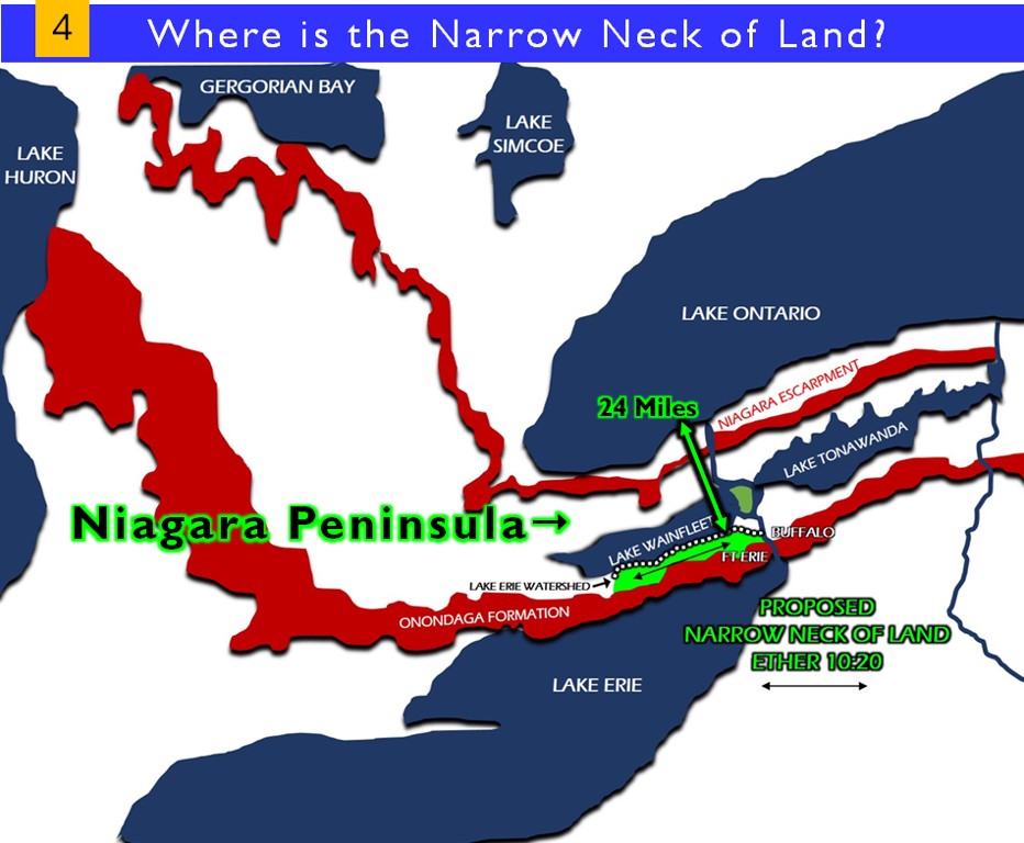
Onondaga Formation
The Onondaga formation in Pennsylvania includes all strata between the overlying Marcellus black shale and the underlying Oriskany sandstone. It consists of four members, lithologically distinct, but intergradational with one another and faunally indistinguishable. In the east a cherty limestone member overlies the Esopus shale member; in central Pennsylvania, a non-cherty limestone member succeeds a limy shale member. Local variations in lithology and thickness and minor disconformities are known. The upper contact of the formation, however, is usually transitional; and the lower contact is everywhere a disconformity. Because of its close faunal and strati-graphic affiliation with the overlying beds, the Onondaga formation in Pennsylvania is now assigned to the position of lowest formation of the Hamilton group of the Middle Devonian. https://www.journals.uchicago.edu/doi/abs/10.1086/624456?journalCode=jg
The Onondaga Limestone is a group of hard limestones and dolomites of Devonian age that form an important geographic feature in some areas in which it outcrops; in others, especially its Southern Ontario portion, the formation can be less prominent as a local surface feature.[citation needed]
In upstate New York and southern Ontario the sedimentary rocks tend to slope slightly southward, and the Onondaga outcrops in a line that usually forms an escarpment (the steep face of a cuesta), because of its resistance to erosion. The outcrop can be traced from the Hudson River valley westward along the southern rim of the Mohawk River valley, passing just south of Syracuse, and along the northern heads of the major Finger Lakes to Buffalo, New York. From Fort Erie, Ontario it runs to Windsor just north of the Lake Erie shoreline, becoming less prominent as one travels westward. It is not distinct west of Windsor, but begins to become noticeable as a steep hill just northwest of Leamington, as it forms a low ridge/escarpment along much of the Lake Erie shoreline.
Chittenango Falls
In several spots it is breached by geologically young streams and spectacular waterfalls are formed, such as at Chittenango Falls just east of Syracuse, Buttermilk Falls at Le Roy, New York and Indian Falls west of Batavia.
A few other breaches occur in older valleys, which likely once had waterfalls, but erosion eventually obliterated them. Such breaches occur at the Tully valley, the Genesee River valley near Avon, New York, and at Port Colborne, Ontario, where the old valley forms a harbor on Lake Erie.
The formation is broken by the only major fault line in western New York, the Linden Fault just east of Batavia, where the eastern side of the fault has dropped down and the ledge moved southward relative to the western side. On the western side of the fault in Genesee County the escarpment achieves its greatest prominence. The New York State Thruway has a rock cut at Batavia which clearly shows the fault and is a popular point for geology class field trips.[1] The fault, which runs from Attica, New York northward to Lake Ontario, is still active and periodically causes minor earthquakes in the area.
The Onondaga Limestone also can be found in other areas where rocks of the same age outcrop, such as in western Pennsylvania and Michigan but they do not form prominent geographic features.
A similar and more prominent outcrop known as the Niagara Escarpment runs parallel and about 25 miles (40 kilometers) to the north through upstate New York, but curves northwestward in southern Ontario toward Lake Huron and eventually into Michigan’s Upper Peninsula and Wisconsin’s Door Peninsula.
Another smaller outcrop known as the Portage Escarpment lies about 35 miles (56 km) to the south, running along the southern ends of the Finger Lakes and forming Cascadilla, Ithaca and Buttermilk Falls in Ithaca.
The Onondaga Escarpment contains significant outcrops of flint (a type of chert) which bears the escarpment’s name. This variety of chert was of great importance to First Nations peoples throughout Southern Ontario, who used it to make stone tools (lithics) such as projectile points and hide scrapers. This variety of chert, which is of reasonably high-quality and which was highly valued by First Nations peoples, is often a common variety of chert recovered archaeologically from sites relatively adjacent to outcrops; for example, Onondaga-variety chert comprises 95% of all of the flint material from some sites in Milton, Ontario. The material has also been found as well at some distance from its original source; Onondaga chert has been recovered at the late archaic Duck Lake archaeological site in northern Michigan,[2] circa 400 kilometers from the nearest outcropping of the material. This wide distribution implies either a very large seasonal migration of ancient peoples or long-distance trade routes, with both likely being the case at different times throughout the prehistory of the Great Lakes region.[3] https://en.wikipedia.org/wiki/Onondaga_Limestone
The Scioto River Valley: “Keeping Promises in the Promised Land
We here in Scioto County live in the Scioto River Valley. It is a locale rich in natural resources and rich in American history. From the dramatic river confluence of the Scioto and the Ohio rivers in Portsmouth to the wide bottoms north of town, the valley – framed by lush native hills – offers a gorgeous landscape that should never be taken for granted.
A pertinent question for locals is “How much do you know about your homeland?” According to historian Andrew Lee Feight, the need to know is extremely important. He recounts a famous song that echoed that very notion:
“’Come all ye likely lads that have a mind for to range, Into some foreign country, your fortunes for to change; In seeking some new pleasures we will all together go, An’ we’ll settle on the banks of the pleasant Ohio.’ So went the old song, which James Keyes used in 1880 as a preface to his collection of sketches detailing the lives of pioneer settlers near the mouth of the Scioto River.
“For many, the Scioto Valley was an American Promised Land and it filled rapidly with men, women, and children, a seemingly restless people who were chasing their fortunes in the newly opened lands of the Trans-Appalachian West.”
Allow me to shed a little light on the valley we call home. It is my hope that this exposition may reward you with a new understanding of our land and our forefathers.
The Scioto River Valley
The geologic history of the Scioto River is tied to the destruction of the Teays River network during the Ice Ages and consequent creation of the Ohio River. As the Ice Age began to cool the earth, and large glaciers began to creep south from modern-day Canada, many landforms and features were changed or destroyed. The Teays River’s path once traveled through modern-day West Virginia, Kentucky, Ohio, Indiana, and Illinois, finally emptying into the Gulf of Mexico, which at the time extended to southern Illinois.

The north flowing Teays River was dammed by glaciers, and damming of other rivers led to a series of floods as lakes overflowed into adjacent valleys. These Pre-Illinoisan (Early Pleistocene) glaciations brought an end to the Teays River.
The advance of ice sheets eventually dammed the Teays resulting in the formation of glacial Lake Tight. Glacial Lake Tight is estimated to have been two-thirds the size of modern Lake Erie. The lake extended into portions of Ohio, West Virginia, and Kentucky and covered approximately 7000 square miles. Valleys beyond the reach of glaciers were reorganized to create the Ohio River, and the Scioto River replaced the Teays River. The Scioto River flows through segments of the Teays River valley but opposite the direction the Teays River flowed.
The Scioto River then ran in a channel about 100 feet below its present bed. All its tributaries near their months were 100 feet lower than now. This made their flow much more rapid, and the growing process was very active. Every flood carried out of the tributary valleys an immense amount of eroded debris. Thus was the valley formed and fashioned into its present size and shape.
Had it not been for the upheaval there could have been no erosion; and without erosion the geological and stratigraphical formation of the valley would not have occurred. This glaciers gave birth to the valley, with all its living organisms.
Human Habitation
The Scioto River is fully 231 miles in length. Humans have inhabited the region for thousands of years. The river valley was home to many Native American cultures. The best known group was the Mound Builders of the Hopewell tradition. Of course, water is essential for life, but the Scioto also offered fertile land for homesteading pioneers – both Indian and white.
Here is a poetic view of the Scioto in the History of Lower Scioto Valley, 1884 …
“Drainage is not the entire object of our river systems. Irrigation and exposure of deep and otherwise hidden treasures are evidently had in view by the Author of Nature with all is elementary combinations. He that makes eyeless fishes where no light can every penetrate would not upheave and plow down the earth’s crust without having in view some special object. Scioto Valley is not, by any means, destitute of the foot-prints of the Deity, but is proof of his handiwork …
“But, aside from the ancient denizens of the Scioto Valley, let us view the inhabitants of the valley when first seen by the Caucasian. Not a tree had yet fallen before the ax of the white man. Among the waving branches of the heavy timbered bottoms, and on the stately oaks of the hills, were heard the notes and cries of birds of various plumage, new and strange. The Indian whoop, the panther’s cry, the hoarse growl of the bear, the howl of the wolf, mingled with thousands of notes of animated beings of a new world. Is he dreaming? Or, does he behold the animated beings of a literal country, like the ones left behind him?”
Yet, why, as a rule, did most early inhabitants of the Scioto Valley settle in the hills, some distances from the river instead of in the rich bottoms?
Despite the resources offered by the valley, both natives and whites had to deal with one persistent threat in the idyllic setting – flooding. Floods posed problems for habitation. Some were particularly devastating. For example, in 1753, a massive flood overflowed both the Scioto and Ohio River banks and completely destroyed the native village of Lower Shawneetown.
Andrew Feight wrote this about the event …
“Having themselves only recently returned to the region, at least three generations since their ancestors had been expelled, the Shawnee were apparently unfamiliar with the occasional massive floods that can make the annual, predictable floods, which inundate the area’s bottom lands, seem unremarkable. The Flood of 1753 would undoubtedly compare with the devastating flood of 1937, which swallowed much of Portsmouth and many other towns along the Ohio River.”
Not only did the river valley present threats of flooding waters, but also it harbored other serious health hazards.
According to James Emmitt, one of Waverly’s prominent fathers …
“Vegetation in the bottoms, in those days, was absolutely rank. Sycamore, black walnut and hackberry trees grew abundantly and to splendid proportions, and the vines of the wild grape clambered up in a dense and tangled mass to their very tops, interlacing their branches, and often uniting many trees in a common bond of clinging vines.
“The growth of weeds and underbrush was wonderfully dense, and when the floods would come and cover the bottoms, several inches of water would remain in those brakes of weeds for months after it had receded from less densely overgrown ground.
“As a matter of fact, the water would stand almost the year around, in lagoons, over a large portion of the bottoms, converting them into huge marshes, and causing them to closely resemble much of the swamp land now so abundant in the South.”
The bottom lands were called “immense tracts of poison-breeding land, marshy in nature, and wholly unfit for the agreeable habitation of man.” The lowlands were “reeking with malaria” and “ague” that was described as “almost as malignant as yellow fever.” Reports say “when a man was seized with the shaking ague, as it manifested itself in 1818-20, he imagined that a score of fiends were indulging in a fierce warfare over the dismemberment of his poor person.”
Emmitt wrote:
“Oh, what torture it was! After the terrible quaking ceased then came the racking, burning fever, that scorched the blood, parched the flesh, and made one pray for death. Torture more absolute and prostrating could not well be conceived of. And when it is remembered that no one who dared brave the dangers of the bottoms was exempt from ague, in some one of its many distressing forms, during the entire spring and summer seasons, and often year in and out, it is not surprising that the early settlers shunned what was to them a plague-stricken district.”
Thus, the hill country bordering the bottoms was first settled by whites. Then the bottoms were “gradually conquered” as residents worked from their outer boundaries clearing away timber, vines, and underbrush. Once the land was cleared, the sun converted it into “workable condition.” And, fever and ague grew less prevalent as the land was cleared up.
The pioneers turned up rich bottom lands since the debris – once an impediment that had kept floods from receding quickly – also produced a positive consequence. At every rise in the river, the water was held on the bottoms until “they had become enriched by a heavy deposit of the soil carried down from the hilltops.” However, once cleared, the bottom lands suffered more soil loss from the currents of flood waters. It seems nature provides and also takes away.
The Scioto River Valley remains one of the most fertile and beautiful areas of the country. Often people overlook the bountiful nature of their own environment, preferring to revel in memories and images of faraway places. The gem we in Scioto are entrusted to protect rivals any other natural wonder. Perhaps we should do much more to enjoy this gift and to enhance its being. These are promises that would benefit all who here dwell.
Sources:
James Emmitt. Chillicothe Leader. 1886. Found at “Pike County” on rootsweb.ancestry.com.
Andrew Lee Feight Ph.D. “Lower Shawnee Town and the Flood of 1753. Lower Scioto Blog. December 24, 2007.
Andrew Lee Feight, Ph.D. “Settling the Scioto Valley.” Tour curated by: Andrew Lee Feight, Ph.D. sciotohistorical.org.
R.P. Goldthwaite. “The Teays Valley Problem, a Historical Perspective”, pp. 3-8 in Wilton N. Melhorn, 1991, Geology and Hydrogeology of the Teays-Mahomet Bedrock Valley Systems, Geological Society of America Special Paper
Kay L. Mason. History of Lower Scioto Valley Ohio. usgwarchives.net.
Ohio Statewide Files – History: Chapter 4, History of Lower Scioto Valley. Chicago. 1884. Source