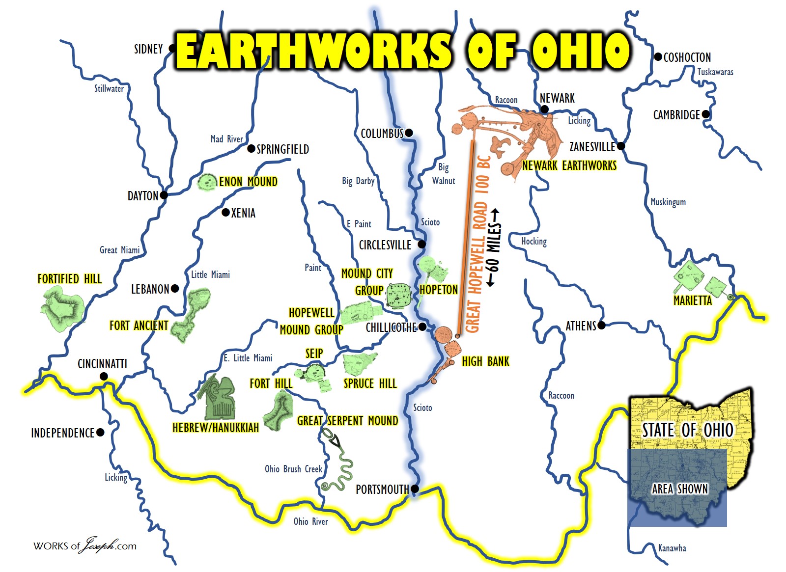
The State of Ohio contains a larger number of prehistoric remnants than any other equivalent area in the Mississippi valley. Some have estimated the number of mounds at 10,000 and the enclosures, villages, and caches at around 1,500, making the total number of earthworks in Ohio more than 11,000.
Since its inception in 1966, more than 80,000 properties have been listed in the National Register. Together these records hold information on more than 1.4 million individual resources including buildings, sites, districts, structures, and objects which provides a link to the country’s heritage at the national, state, and local levels.
There are over 3,700 properties and sites listed in Ohio. Of these, approximately 200 are prehistoric locations. Within Ohio’s 88 counties, 50 counties include prehistoric sites listed in the National Registry. Do you know of a mound or earthwork site that is not protected? We can help you register your site with the National Register.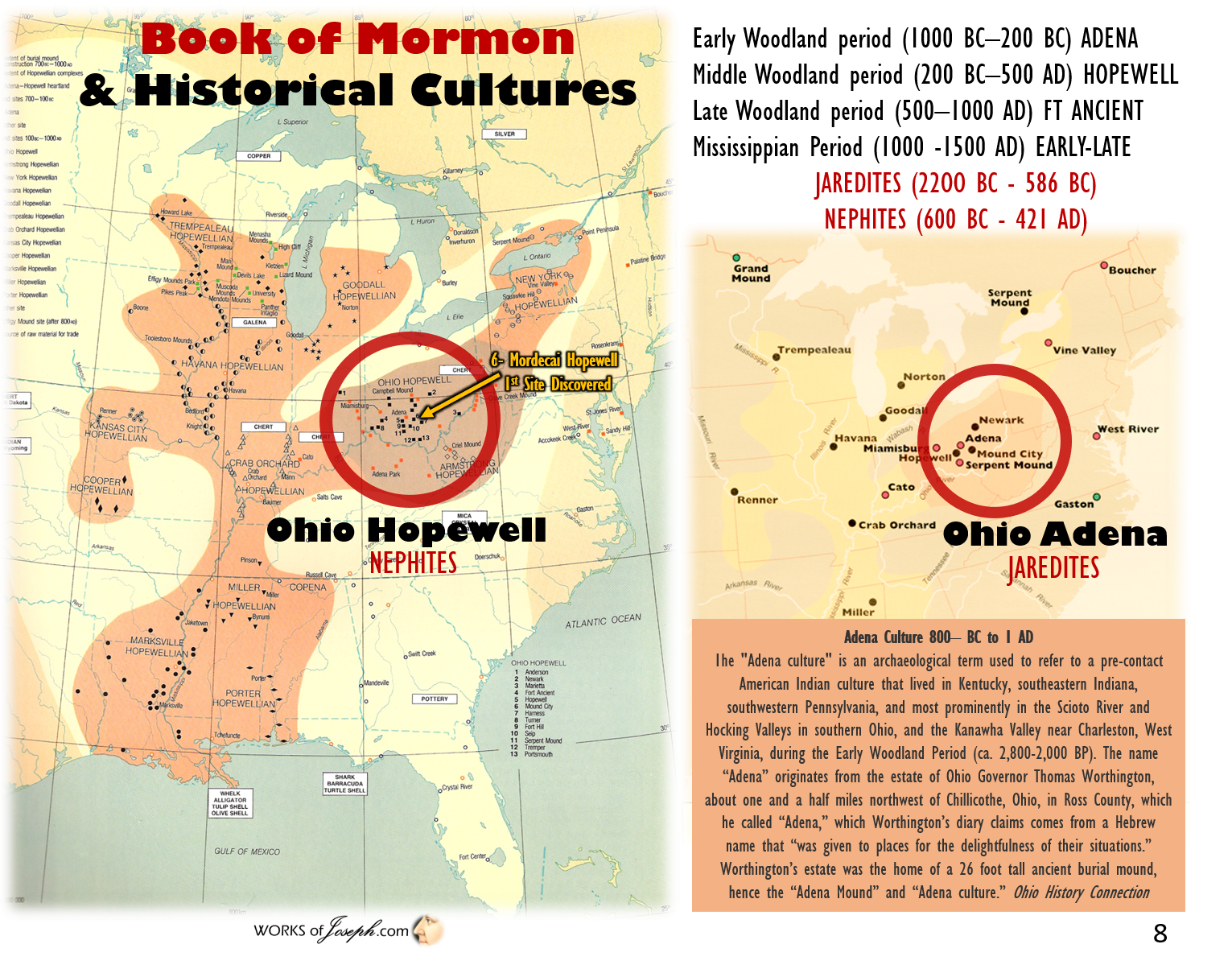
The following chart is from the Archaeological Atlas of Ohio which was published in 1914. Many of the mounds and earthworks were destroyed by farming and development by this time. This chart shows the number of recorded and mapped mounds:
1914 Archeological Atlas of Ohio by Wm. C. Mills.
The territory embraced within the State of Ohio probably contains a greater number of prehistoric remains than any other equal area in the Mississippi valley. The number of these earthworks has been variously estimated. Some writers have estimated the number of tumuli at 10,000 and the enclosures, etc., at 1,000 to 1,500, making the total number of earthworks more than 11,000, As a matter of fact these estimates were based upon what was known of such counties as Scioto, Ross, Pickaway, Butler, Hamilton, Warren, “Washington and Licking, all of which were great centers of prehistoric activity.
If all the counties in the state were dotted over with the earthworks of prehistory man, as are the counties mentioned, the estimate would be inadequate. But we find the entire northwest part of the state unsuited in prehistory times for occupancy by a prehistoric people, as the greater portion was low and swampy and at certain seasons of the year covered with water. [The Black Swamp shown below]
Again the southeast part of the state was entirely too rough and hilly and the valleys of the streams small, so that agriculture was carried on with great difficulty. The valleys of the two Miamis, Scioto and Muskingum were well adapted for the abode of prehistoric man and here we find his principal monuments. The task of recording these monuments was begun in a very early day by Col. Chas. Whittlesey, President of the Western Reserve Historical Society. He had constructed a large 12 X 14 feet wall map and had recorded upon it all the known monuments. This map is now the property of the Ohio State Archaeological and Historical Society and was drawn by Thomas Mathew, Professor of Drawing at the Ohio Agricultural and Mechanical College (State University). No date is marked upon the map but no doubt it dates back to the 1870’s.
In 1891 an Archaeological map of Ohio was published by the Smithsonian Institution, upon which many additional mounds were noted. In 1895 Prof. Warren K. Moorehead constructed for the Society a new Archaeological map and commenced to map the state .systematically. The size of the new map was 6×6 feet which was much smaller than the map made for Col. Whittlesey. After Prof. Moorhead’s resignation in 1897 the writer conducted a systematic examination of the State, county by county, verifying wherever possible those monuments already known and at the same time adding new records to the map. After due consideration the Executive Committee of the Society found that a wall map would be entirely too unwieldy and undesirable as a published account of the earthworks of Ohio and they changed the plan of publication to an Archaeological Atlas of Ohio, by counties, a more convenient form for examination and study. In presenting the Archeological Atlas of Ohio, the author wishes to state it is as near complete as is at present possible, remindful of the fact that many monuments have been destroyed by a century or more of cultivation of the soil and by other destructive agencies and that many, no doubt, exist that we have no records of.

The various classes of earthworks shown on the maps of the Atlas are as follows:
Mounds (mortuary)
Enclosures (circular, crescent and square)
Village sites burials (ordinary interments)
cemeteries
stone graves
effigies
petroglyphs
flint quarries and caches.
The symbols designating the various earthworks are shown in the subjoined cartographic table (left): The mound, for the most part erected as a monument to the dead, is the best known and most abundant of the earthworks of Ohio. They are usually conical in form and varying in height from a few feet to 67 feet and in diameter from 10 to several hundred feet. They may occur singly or in groups but always in close proximity to their villages.
Ross County has 370 recorded burial mounds; Licking County has 225, Butler County 221, Jackson County and Pickaway County tie for fourth place with 173 each, while Auglaize, Henry and Wood counties have no records of a single mound. Total number of recorded mounds in the state of Ohio is 3,513.
The division of enclosures into three classes — the circular, the square and the crescent — is merely an arrangement of convenience suggested by their forms and is not necessarily indicative of purposes for which they were constructed. With respect to purpose and location, the following classification probably is more desirable:
“Hilltop enclosures, of irregular form, conforming to the topography of the mound on which they lie and from the natural strategic advantage of their position, suggesting a military. that is, a defensive use, closures, geometric in design more or less symmetrical and located on low or level lands, the purpose of which may have been the same, but perhaps constructed by a different culture; among enclosures partaking somewhat of the characteristics of the two preceding classes but located on high or low ground apparently with little regard to topography.
Fort Ancient, in Warren County, is the best example of the hill-top enclosures of the state. Enclosures of this class usually are constructed of stone and earth combined, and occur most frequently in the southern half of the state though not uncommon elsewhere. The best examples of the second named (the square) class are found in Licking, Ross, Butler, and other counties contiguous to the Muskingum, Scioto and Miami rivers. They take the form of circles, squares, crescents, etc., singly or in combination and usually are constructed entirely of earth. The third class of enclosures (the crescent) occur principally in the southern portions of the state and in several counties south of Lake Erie. They vary greatly in form and location and consequently in probable uses. The total number of enclosures recorded in the various counties of Ohio is 587.
Ross County stands first with 49, Licking County 36, Pickaway County 33 and Franklin County comes fourth with 28. The village sites marking the places where aboriginal villages or camps existed are scattered pretty generally over the state. They furnish intimate data regarding the domestic life of the aborigine. Among the important village sites are the Baum village site and the Gartner site, in Ross County. Both have been explored by the Society and the results printed in the Society–s publications. The total number of village sites recorded in the state is 354. Miami County leads with 35 recorded sites, Jackson County 22, Hamilton 17, and Darke County 13.
Cemeteries and burials are self-explanatory. They usually occur in or near village or camp sites. The stone grave is merely a local variation of burial custom occurring most frequently along the Ohio River where the abundance of slabs of loose stone encouraged their use in preparing graves. Of the effigy mounds, the greatest is the Serpent Mound of Adams County. Others are the Opossum Mound of Licking County, the Warren County Serpent, the tapir like figure in Scioto County and several anomalous figures in Pickaway, Ross and other counties. These works are described under their respective counties.
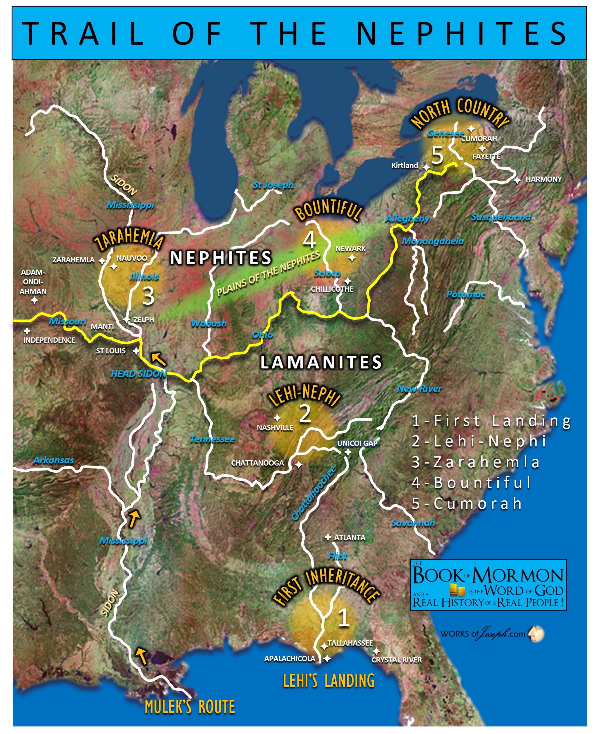
Trail of the Nephites
 Petroglyphs or rock pictures are found cut into exposed rock surfaces and are most abundant along the Ohio River. Among the more important of the petroglyphs are those in Jackson, Meigs, Belmont, Columbiana and Cuyahoga counties and are described under those counties. Flint quarries, the principal ones of which are located in Licking, Muskingum and Coshocton counties, were of great importance in the aboriginal economy. Their purpose is evident — the supplying of raw material for the manufacture of the multitude of chipped flint objects found in practically every section of the state.
Flint Quarries recorded number 109. The total number of the various classes of earthworks recorded upon the maps of the Atlas are: Mounds (burial) 3,513 Enclosures (Square, circular and crescent) 587 Village Sites 354 Burials (Ordinary internments) 714 Cemeteries 39 Stone Graves 17 Effigy Mounds 5 Petroglyphs 16 Flint Quarries 109 Caches 6 Rock Shelters 35 Total 5,395
The author (of the 1914 Archeological Atlas) is under many obligations to Mr. H. C. Shetrone for his untiring efforts in assembling the records of the earthworks and placing the marks in the proper position on the maps and for personal examination of sections along the Ohio River. To Mr. Phillip Hinkle of Cincinnati for furnishing the records for Hamilton County. To Mr. Almer Hegler for furnishing the records for Fayette County. To Judge H. C. Miller and Mr. F. E. Bingman of Jackson for the records of Jackson County. The author is also indebted to many others in the various counties of the state, who aided in many ways to furnish records and assist in locating the archeological remains for a permanent record. Wm. C. Mills. Columbus, Ohio. March, 1914.
North Perry County, Ohio
http://ohiomounds.com/wp-content/uploads/2012/08/Finding-Ohio-Mounds-Sample-Chapter.pdf
Parallels of the Hopewell Culture
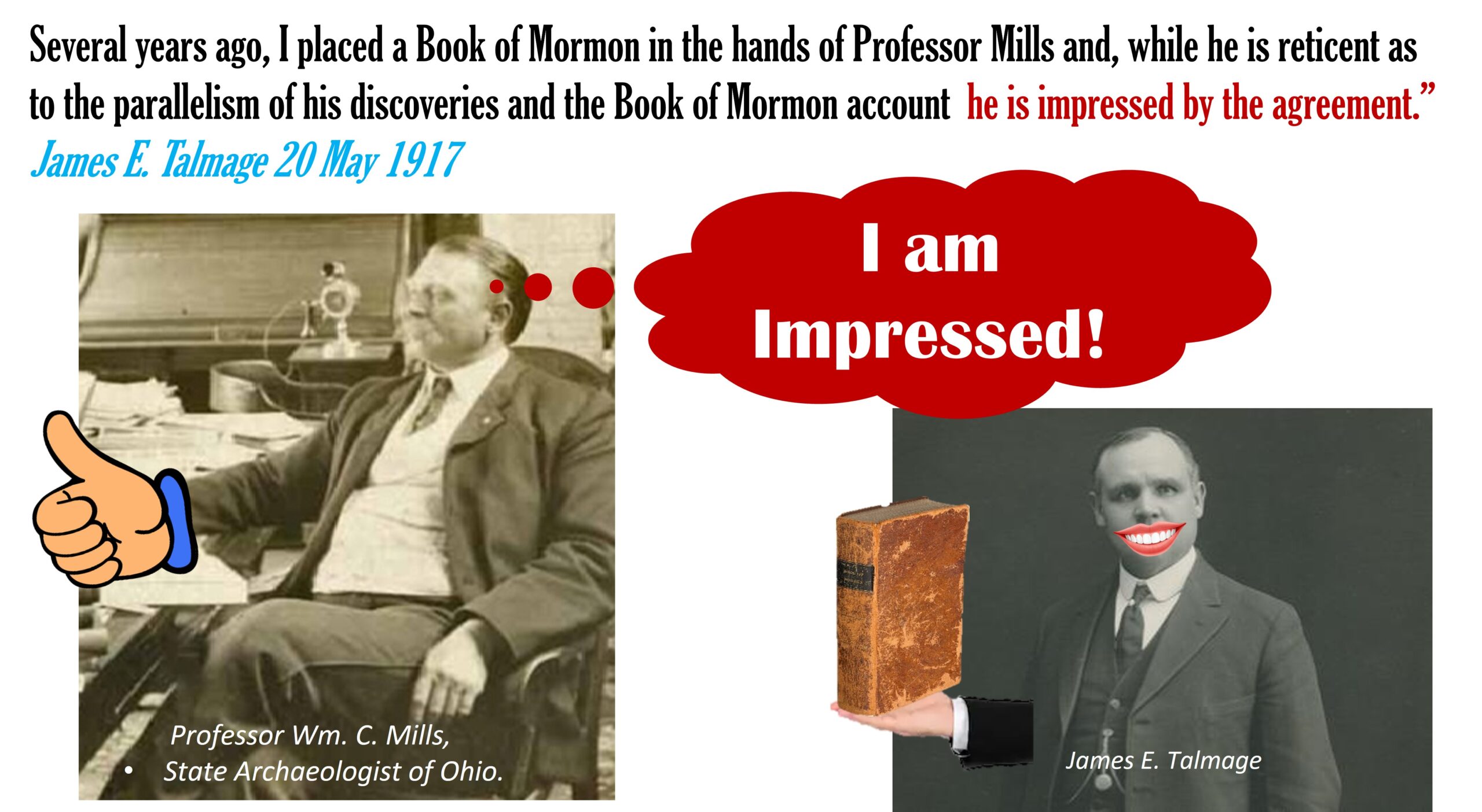 James Talmadge said, “Parallels of the Hopewell Culture as described by William C. Mills, Chief Archaeologist of Ohio, with the Book of Mormon. [May 20, 1917; Sunday] Attended Sunday School and afternoon service in Hawthorne Hall, and was a speaker at each assembly. Evening meetings here, as also in Brooklyn, have been discontinued for the summer. The attendance both at Sunday School and afternoon meeting was surprisingly large in view of the fact that many of the Utah college students have left for the vacation period. This evening at the hotel I had a long and profitable consultation with Professor Wm. C. Mills, State Archaeologist of Ohio. He is continuing his splendid work of exploration in the Ohio mounds, and I went over with him again the remarkable agreement between his deductions and the Book of Mormon story.
He has reached the following (10) conclusions: The area now included within the political boundaries defining the State of Ohio was once inhabited by two distinct peoples, representing two cultures, a higher and a lower. These two classes were contemporaries; in other words, the higher and the lower culture represented distinct phases of development existing at one time and in contiguous sections, and furnish in no sense an instance of evolution by which the lower culture was developed into the higher.
These two cultural types or distinct peoples were generally in a state of hostility one toward the other, the lower culture being more commonly the aggressor and the higher the defender. During limited periods, however, the two types, classes, or cultures, lived in a state of neutrality, amounting in fact to friendly intercourse.
The numerous exhumations of human bones demonstrate that the people of the lower type, if not indeed both cultures, were very generally affected by syphilis, indicating a prevalent condition of lasciviousness.
There (are) two peoples or cultures…the lower culture was most commonly the assailing party, while the people of the higher type defended as best they could but in general fled.
 As a further consequence of this belligerent status they buried their dead, with or without previous cremation, in such condition as to admit of expeditious covering up of the cemeteries by the heaping of earth over the sepulchers [sic], in which hurried work the least skilled laborers and even children could be employed.
From a careful collating of data it is demonstrated that the general course of migration through the area now defined as the State of Ohio was inward from the west and outward toward the east.
Professor Mills states that no definite data as to the age of these peoples have as yet been found, but that the mounds may date back a few hundred years or even fifteen hundred or more. Several years ago I placed a Book of Mormon in the hands of Professor Mills and, while he is reticent as to the parallelism of his discoveries and the Book of Mormon account, he is impressed by the agreement.” James E. Talmage 20 May 1917
Tony & Lorraine George
“Ancient Clues from Old Ohio History”
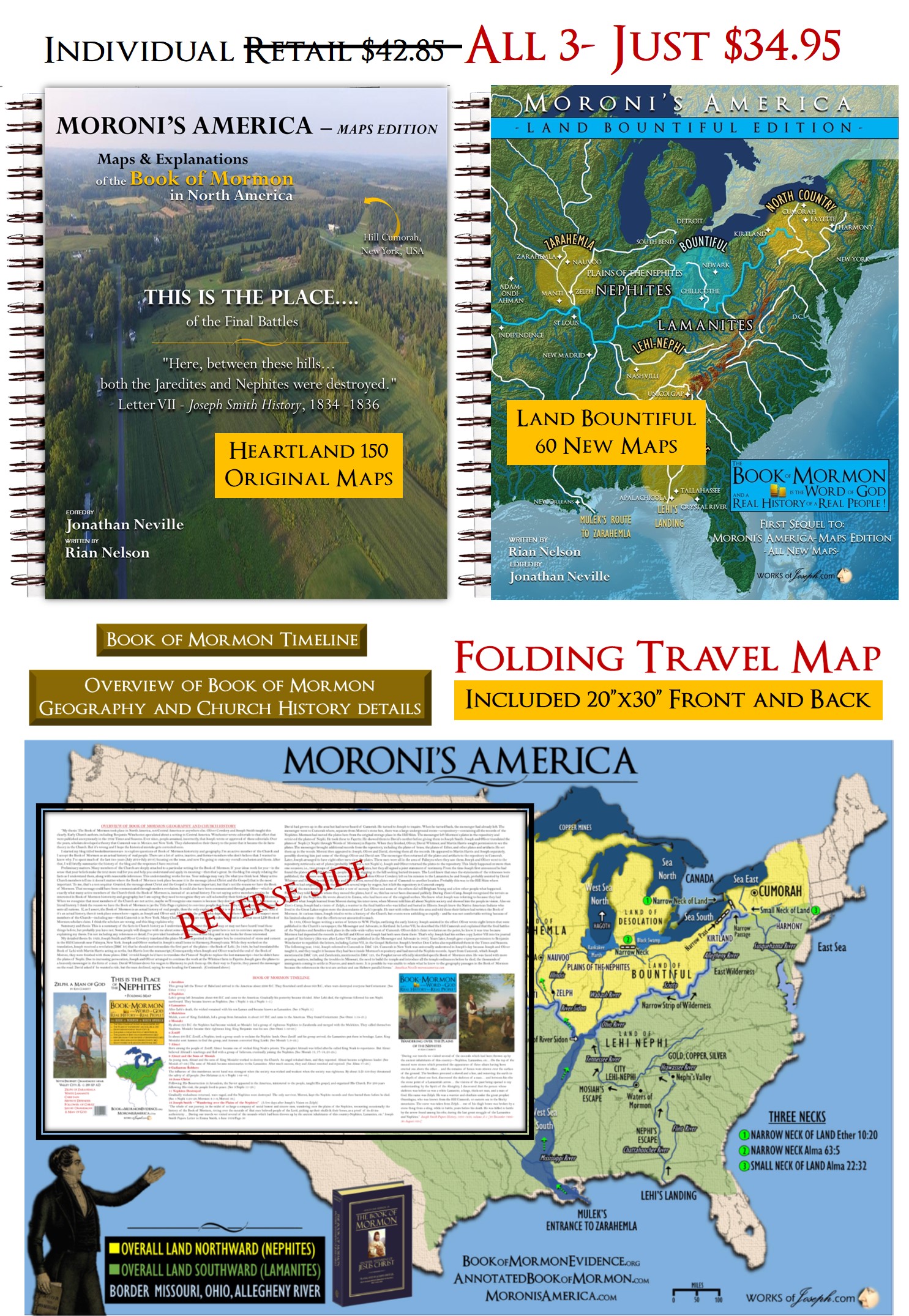
Tony and Lorraine have been researching the Mound Builder culture most of their lives. Tony was born and raised in southern Ohio, otherwise known as Hopewell Central, and follows in the footsteps of his father’s passion. Lorraine, his high school sweetheart, joined with him on an early date to Hopewell Culture National Historic Park, and the rest is history, literally. Having been surrounded by countless earthworks during their life and working closely with current archaeologists, they share enthusiasm and excitement and their love of history with countless visitors to Ohio. Purchase their Map Book called Moroni’s America Maps,”Land Bountiful Edition” HERE
“Lorraine is a princess of very distant royal ancestry who courted and married an Appalachian goober. Her family has roots in the early history of The Church of Jesus Christ of Latter-day Saints. Tony’s family arrived in the Ohio valley seven generations ago, among the earliest of pioneers in that region. He has been the beneficiary of stories and observations of the ancient peoples and their land and has continued the pursuit with earnestness. He has served as a Bishop and in various other capacities in Church and community organizations. Together they provide a simple but curious perspective of an ancient culture who kept their eyes aligned to the horizon, but their hearts to the heavens.”
Possible Places for The Savior’s Appearance –
Principal location of Ross County Ohio – even in historic times, the geology, geography, and biotic zones have been recognized as significant and even desirable for habitation. Modern Chillicothe serves as regional commerce center and a crossroads of transportation. The Scioto River and large tributaries in Paint Creek and Deer Creek converge in one relatively concentrated region. The Shawnee revered the place. Ohio pioneers made Chillicothe the first capital of the newly formed state.
Sugarloaf Mountain, Ohio – Eternal Geography
 Sugarloaf Mountain – “The Hopewell road from Newark points straight as an arrow to Sugarloaf Mountain, the hill directly behind the Cedar Bank site. It is also the hill which many Chillicothe earthworks align to. Additionally, the Marietta Road, another ancient thruway, points straight to Sugarloaf from Marietta. Then consider the Kanawha Trail from Charleston WV and the Scioto Trail from Portsmouth OH…yep, the same. It seems everything in southern Ohio points to Sugarloaf. And there is more. The largest concentration of Hopewell earthworks are within minutes of Sugarloaf (over 500). You can see Columbus OH from the top of the hill. It commands the valley more in presence as opposed to height. Anthony George Lifelong Resident of Chillicothe, Ohio and Archaeological Researcher.
 Trail#1– The “Great Trail” so-called, was the most important of the east and west trails in Ohio. It was the western extension of the great highway between the Indian country around Delaware and Chesapeake Bay traveling westward to the forks of the Ohio
Trail #2- Of striking importance was the Scioto trail running north and south through the state, between Sandusky Bay,“ and the mouth of the Scioto River. Ascending the Sandusky River crossing the portage and descending the Scioto to its juncture with the Ohio, the Scioto trail crossed the 1atter river and joined the famous “Warrior’s Path”, leading far into the southland.
Trail #3- This trail connected the Indian country about the forks of the Muskingum with the Shawnee settlements on the Scioto and thence west and north to the important Miami towns.
Trail #13- Extended from Maguck [Circleville] southeast to the Muskingum River thence southward, crossing the Ohio river in Washington County. This was a well-known war trail from the Shawnee settlements on the Scioto to the Indian settlements in southwestern Pennsylvania.
ARCHAEOLOGICAL ATLAS OF OHIO INDIAN TRAILS AND TOWNS
By William C. Mills 1914
5,396 OHIO ARCHAEOLOGICAL SITES Identified by 1914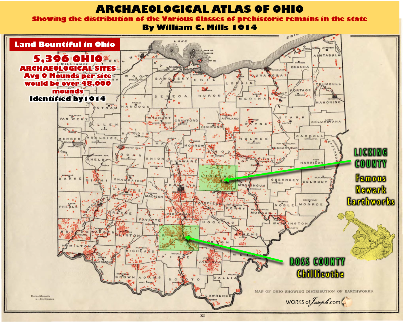
The importance of the aboriginal trails of Ohio to the settlement and development of the state, hardly can be overestimated. In many instances they determined the location of the early white settlements as well as the first forts and military roads, many of them later becoming permanent highways. They ranged in width from a mere trail threading the wilderness to paths of a few feet wide in the more open country and generally followed the high ground between the water courses of hills and ridges adjacent to the streams. It was along these trails that the aboriginal Ohio peoples traveled from one part of the state to another, whether engaged in warfare, the chase, trade and barter, or migration. Later they served, together with navigable streams, as the only means of entrance for the white traders and settlers who pushed their way into the country west and north of the Ohio River. Thus, the trails in great measure determined the course of improved highways and in this way strongly influenced the location of communities and towns.
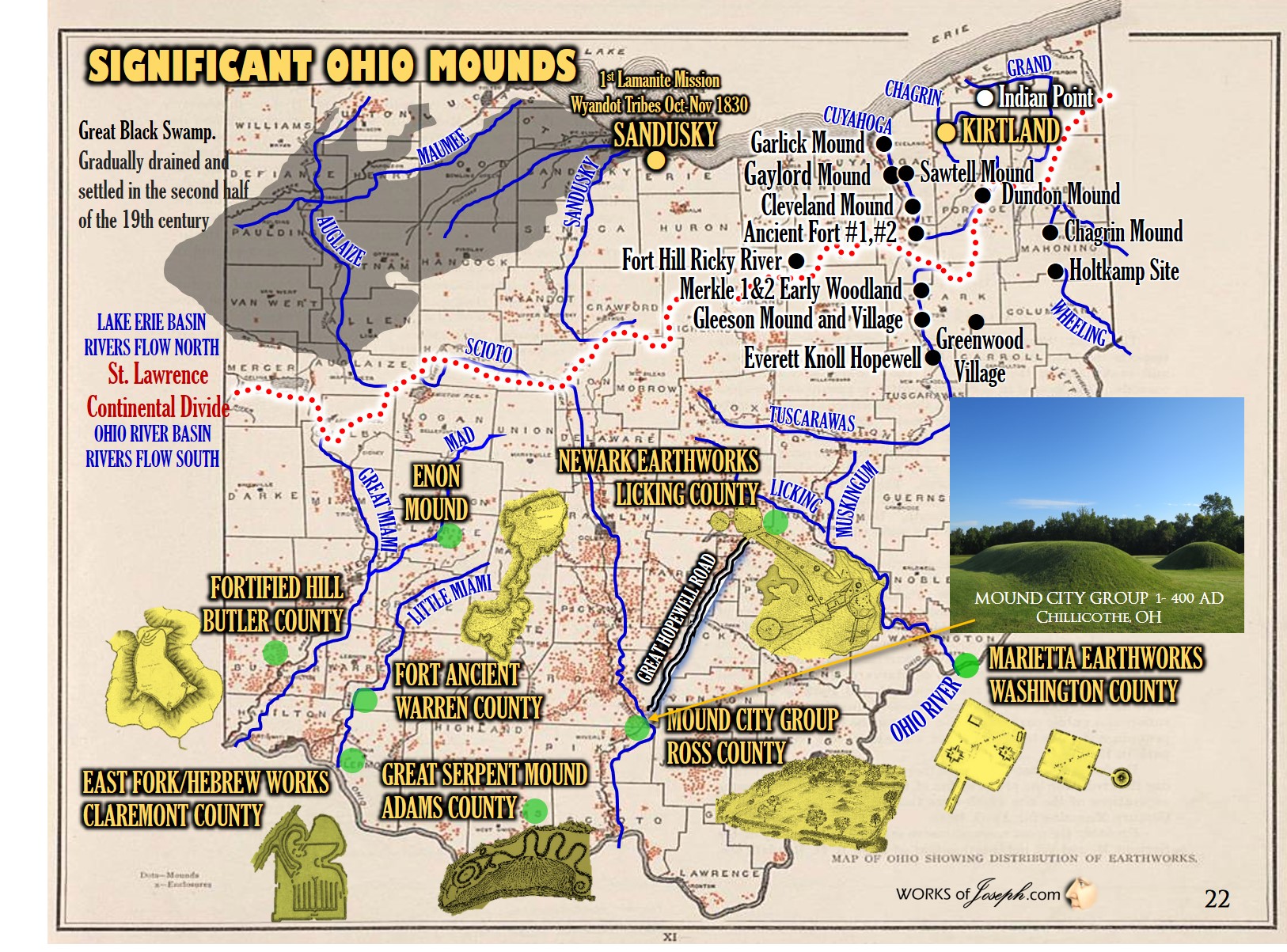
SPECIFIC EARLY WOODLAND MOUNDS AND SITES AROUND CLEVELAND
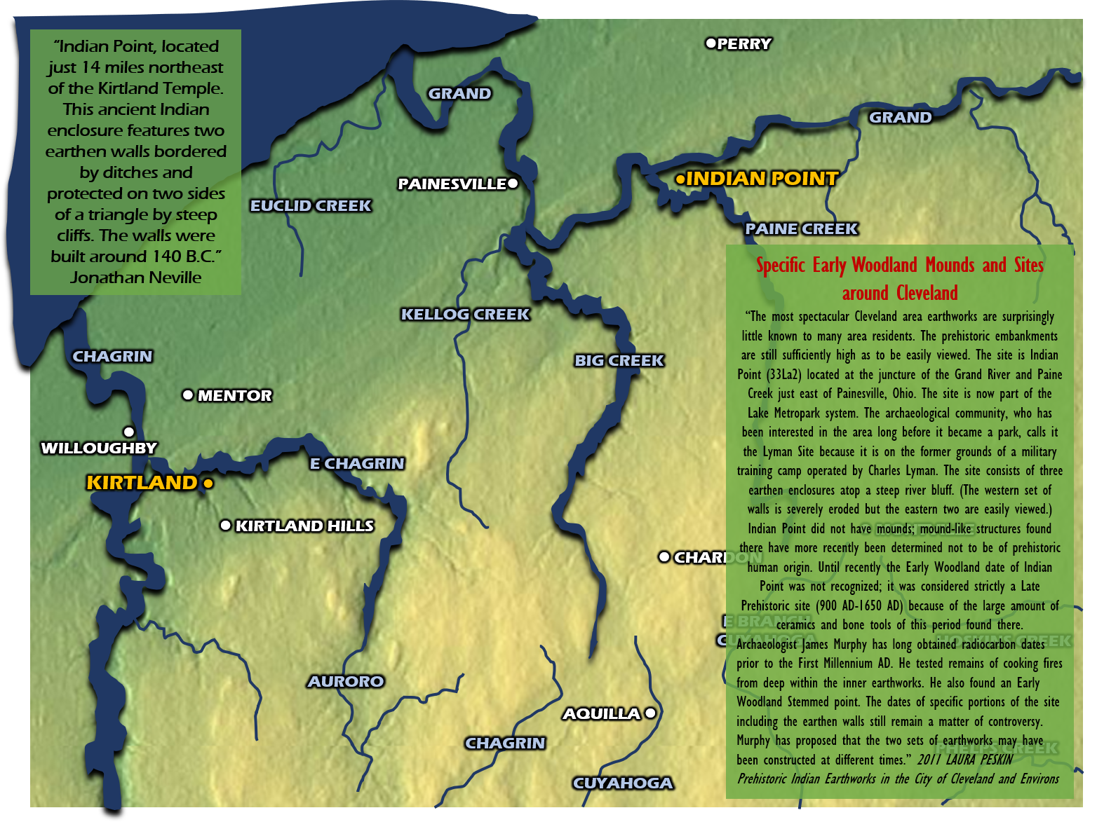
“Indian Point, located just 14 miles northeast of the Kirtland Temple. This ancient Indian enclosure features two earthen walls bordered by ditches and protected on two sides of a triangle by steep cliffs. The walls were built around 140 B.C.” Jonathan Neville by reading the signage at the site.
“The most spectacular Cleveland area earthworks are surprisingly little known to many area residents. The prehistoric embankments are still sufficiently high as to be easily viewed. The site is Indian Point (33La2) located at the juncture of the Grand River and Paine Creek just east of Painesville, Ohio. The site is now part of the Lake Metropark system. The archaeological community, who has been interested in the area long before it became a park, calls it the Lyman Site because it is on the former grounds of a military training camp operated by Charles Lyman. The site consists of three earthen enclosures atop a steep river bluff. (The western set of walls is severely eroded but the eastern two are easily viewed.) Indian Point did not have mounds; mound-like structures found there have more recently been determined not to be of prehistoric human origin. Until recently the Early Woodland date of Indian Point was not recognized; it was considered strictly a Late Prehistoric site (900 AD-1650 AD) because of the large amount of ceramics and bone tools of this period found there. Archaeologist James Murphy has long obtained radiocarbon dates prior to the First Millennium AD. He tested remains of cooking fires from deep within the inner earthworks. He also found an Early Woodland Stemmed point. The dates of specific portions of the site including the earthen walls still remain a matter of controversy. Murphy has proposed that the two sets of earthworks may have been constructed at different times.” 2011 LAURA PESKIN Prehistoric Indian Earthworks in the City of Cleveland and Environs
Cedar Bank Works – Ancient Temple? Chillicothe, OH
Proximity of likely temple site – the Cedar Bank site is a great candidate for a temple site. It is situated on the east bank of the Scioto and below Sugarloaf Mountain. Incidentally, Sugarloaf has a very, majestic shape. Even Squire and Davis suggest Cedar Bank as a place of “religious observances”. And then there is the name ‘Cedar Bank. It is understood that the site was named from the inordinate number of cedar trees growing on a bank among one of the thickest hardwood forests in the world.
 Propagated from an ancient introduction of cedars? Additionally, the earthwork appears to have had a graded way to the water feature. It also resembles very, very closely the constructions found in Marietta, OH, Cincinnati, OH, Havana, IL and what we know as the Zarahemla site across from Nauvoo. Keep in mind that upon the Savior’s coming the people would be practicing the law of Moses. Although the Newark works are wonderful at offering symbolism of the Plan of Salvation through its geometric, earthen constructions, so do likewise other geometric construction’s in Ohio and opposite Portsmouth in Kentucky. These constructions were likely built or ‘added upon’ (from earlier constructions) after the Savior’s coming and teachings. Anthony George, Lifelong Chillicothe Resident & Archeological Researcher (For points 1-5 see page 2)
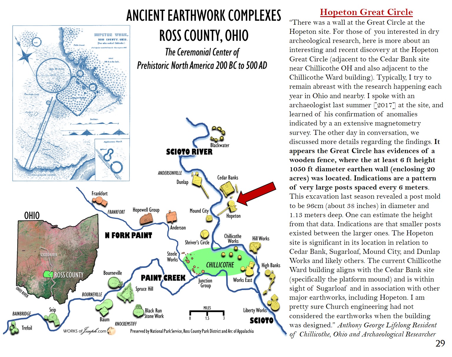
Hopeton Great Circle
“There was a wall at the Great Circle at the Hopeton site. For those of you interested in dry archeological research, here is more about an interesting and recent discovery at the Hopeton Great Circle (adjacent to the Cedar Bank site near Chillicothe OH and also adjacent to the Chillicothe Ward building). Typically, I try to remain abreast with the research happening each year in Ohio and nearby. I spoke with an archaeologist last summer [2017] at the site, and learned of his confirmation of anomalies indicated by a an extensive magnetometry survey. The other day in conversation, we discussed more details regarding the findings. It appears the Great Circle has evidences of a wooden fence, where the at least 6 ft height 1050 ft diameter earthen wall (enclosing 20 acres) was located. Indications are a pattern of very large posts spaced every 6 meters. This excavation last season revealed a post mold to be 96cm (about 38 inches) in diameter and 1.13 meters deep. One can estimate the height from that data. Indications are that smaller posts existed between the larger ones. The Hopeton site is significant in its location in relation to Cedar Bank, Sugarloaf, Mound City, and Dunlap Works and likely others. The current Chillicothe Ward building aligns with the Cedar Bank site (specifically the platform mound) and is within sight of Sugarloaf and in association with other major earthworks, including Hopeton. I am pretty sure Church engineering had not considered the earthworks when the building was designed.” Anthony George Lifelong Resident of Chillicothe, Ohio and Archaeological Researcher
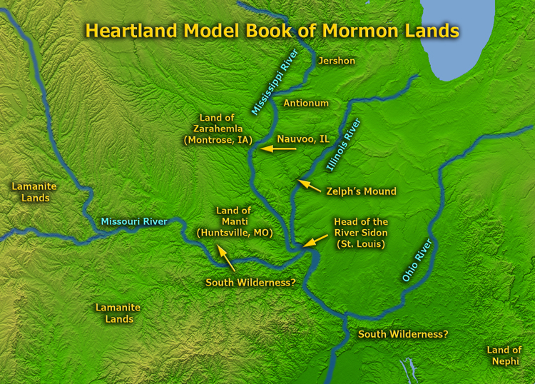
Promised Land Bountiful
“And it came to pass that after we had sailed for the space of many days we did arrive at the promised land; and we went forth upon the land, and did pitch our tents; and we did call it the promised land. And it came to pass that we did begin to till the earth, and we began to plant seeds; yea, we did put all our seeds into the earth, which we had brought from the land of Jerusalem. And it came to pass that they did grow exceedingly; wherefore, we were blessed in abundance. And it came to pass that we did find upon the land of promise, as we journeyed in the wilderness, that there were beasts in the forests of every kind, both the cow and the ox, and the ass and the horse, and the goat and the wild goat, and all manner of wild animals, which were for the use of men. And we did find all manner of ore, both of gold, and of silver, and of copper.” 1 Nephi 18:23-25
The Small Neck of Land
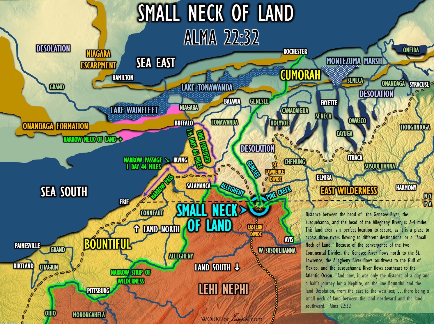
Triple Divide – 3 River Sources
- Susquehanna Flows to the Atlantic
- Allegheny/Ohio Flows to the Gulf of Mexico
- Genesee Flows to the Gulf of St Lawrence
“… I propose that the narrow strip of wilderness is a major river—or system of rivers—that serves as an effective border. Here is my rationale. First, Moroni tells us it is a border. The “narrow strip” element suggests a feature that is visible and obvious to people on the ground; i.e., narrow enough that observers can see how wide it is, and long and thin enough that it is not mistakable. It is a definite border, not a vague region. Second, the definitions of the terms offer similar connotations. Narrow suggests a vale, valley, or river bed. Strip suggests something that is long and thin—like a river… In the past, however—in Book of Mormon times—the Ohio River often dried up in late summer. This left the riverbed as an expanse of silt and mud. In that state, it could not be called a river. But it could still be a border, and it could still be called a narrow strip of wilderness.” Jonathan Neville Moroni’s America page 23, 51-5
Research Group SENSYS Magnetometer Survey
 “James Dutcher, in June 1987, received permission from Elizabeth Cooperrider, the owner, to excavate the stone mound… He measured the mound at 129 feet east to west and 110 feet north to south, with the highest point being 12 feet. Using a backhoe, he removed large portions of stone from the center of the mound, excavating a trench 30 feet by 10 feet on the northwest side of the stone mound. In the trench he found a fire hearth and a layer of charcoal on thirteen flat stones; four post molds were also located. The charcoal was sent to Beta Analytic in Florida in January 1988 for radiocarbon dating, and the results produced a date of 2220 ± 50 b.p., which translated to a date of ca. 270 b.c., suggesting a late Adena or early Hopewell period structure”. Glenford Stone “Fort” and Other Stone Constructions in Ohio and Beyond Norman Muller NEARA Journal, 2010
Many areas in Ohio have had magnetometer surveys. Above left, is an example of what those surveys look like. Experts search for post holes, fire pits, moved earth, and other things 3-5 feet below the surface .
Newark Earthworks
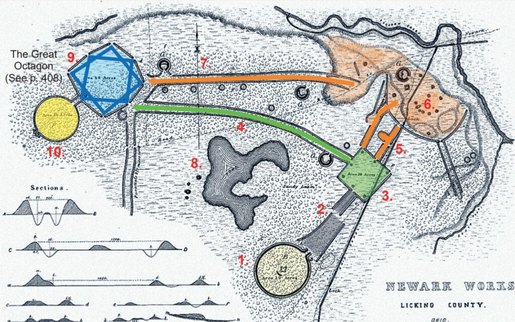 The Newark Works, built between 100 B.C. – 500 A.D. is the largest surviving Hopewell earthwork complex in North America and originally encompassed more than four square miles. Taken as a whole, the earthwork symbols appear to represent a fundamental understanding of the essential elements of the Plan of Salvation:
1. Pre-Mortal Life: The Great Circle (light yellow) may symbolize our spirits eternal nature (circle), being born from a fluid-lined womb which opens toward the east, entering a—
2. Veil of forgetfulness: Two converging paths between the Great Circle and square are juxtaposed symbolizing
our forgetting of the pre-mortal life.
3. Telestial Kingdom: Mortal life (green square) represents earth and is likened to having four corners, “and gather
together the dispersed of Judah from the four corners of the earth” (2 Nephi 21:12).
4. Direct path: If all ordinances are performed on earth the individual can enter this path passing only one checkpoint.
5. Spirit Prison: Entrance from the earth, having only a dead-end holding area for the wicked.
6. Paradise: Another holding area following earth life where the gospel is preached and accepted or rejected.
7. Vicarious path: Those who accept the gospel in Paradise must have their temple ordinances performed by others
thereby passing multiple checkpoints.
8. Lake of Filthy Water: This man-made stagnant lake symbolizes the temptations each person must pass through.
9. Terrestrial Kingdom: (blue octagon), represented as the Seal of Melchizedek or eight-pointed star or octagon.
10. Celestial Kingdom: (gold circle) Entered only through the Terrestrial realm of Melchizedek through a straight and narrow path to be eternally encircled about by God. (Annotated Book of Mormon page 250- Original research by Amberli Nelson)
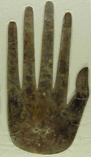
HOPEWELL EFFIGY OF A HUMAN HAND
“Effigy of a human hand cut from sheet mica, Ohio Hopewell culture, 100 BC-500 AD. Excavated from Hopewell Mound Group, Ross County, Ohio ca.1922-1925. The Hopewell obtained mica from western North Carolina. This object is 11” x 7” and is held in the Ohio History Connection Archaeology Collection. Hopewell culture spiritual leaders used small slabs of mica for a kind of mirror, possibly used in divination ceremonies, and artisans cut sheets into a variety of delicate shapes that may have been sewn onto garments to serve as personal ornaments. Around 400 A.D Hopewell culture began to decline for an unknown reason according to archaeologists.” Ohio History Connection Archaeology.
3 Nephi 11: 13-17
Zechariah 13:6
John 20:24-29
D&C 45:52
Pictured-Actual artifact at Ohio History Connection Museum, Columbus, OH
Dr. John C. Lefgren of Bethlehem, PA was the person who first made the association of the Fibonacci Series to this Hopewell artifact which shows the nail print in the hand of Christ. (See great video “The Fibonacci Sequence” here https://www.youtube.com/watch?v=P0tLbl5LrJ8)