
Artifacts, History and Archaeology Provide Strong Evidence for the Book of Mormon Near Cumorah!
There is a belief that the Iroquois Nation played an important role in the life of Joseph Smith. He lived in an area with many Iroquois chiefs and may have even met many of these great men. Ganargua Creek (Mud Creek) was a primary stopover point for the Iroquois on their trade routes. Joseph Smith also had an interest in the creek after hearing a speech from Seneca Indian Chief Red Jacket at Palmyra in 1822.
Many historians believe that Iroquoian ideas of federalism, and balance of power directly influenced the US system of government. Benjamin Franklin admired native American government structures. In 1744, Canassatego advocated in Washington the federal union of the American colonies. See Here

The Iroquois or Haudenosaunee (People of the Longhouse) are a historically powerful northeast Native American confederacy. They were known during the colonial years to the French as the Iroquois League, and later as the Iroquois Confederacy, and to the English as the Five Nations, comprising the Mohawk, Onondaga, Oneida, Cayuga, and Seneca. After 1722, they accepted the Tuscarora people from the Southeast into their confederacy and became known as the Six Nations.
 Handsome Lake
“The Onondagas: These have special interest… this warrior, Zelph, was an Onondaga, as well as a “white” Lamanite, and that the Onondagas (of New York), consequently must be of Lamanite lineage.” J.M. Sjodahl, An Introduction to the Study of the Book of Mormon
“Contrary, then, to widespread assumptions during Joseph Smith’s lifetime that the Onondaga migrated to the New York region, it becomes clear that they originated here as a small, narrowly localized amalgamation of a few villages near Onondaga Lake, during the century before Columbus’ discovery of America” Beauchamp’s Aboriginal Place Names of New York;
County of Onondaga

PROBABLY no county in the State had originally a greater number of aboriginal monuments within its boundaries, than the county of Onondaga. It has, however, been so long settled, and so generally brought under cultivation, that nearly all vestiges of its ancient remains have disappeared. The sites of many are, however, still remembered ; but even these will soon be forgotten. It is a fortunate circumstance that the antiquities of this county were the first to attract the attention of observers, and our accounts relating to them are more complete than concerning those of the other parts of the State. Our principal source of information respecting their numbers, localities, and character, is the memoir of De Witt Clinton, already several times alluded to. Mr. Schoolcraft and Mr. J. V. H. Clark, of Manlius, have presented additional information; and from these authorities we derive most of the facts, and illustrations which follow.
Ancient works occurred in the towns of Fabius, De Witt, Lafayette, Camillus, Onondaga, Manlius, Elbridge, and Pompey ; but of many of them we know nothing beyond the simple
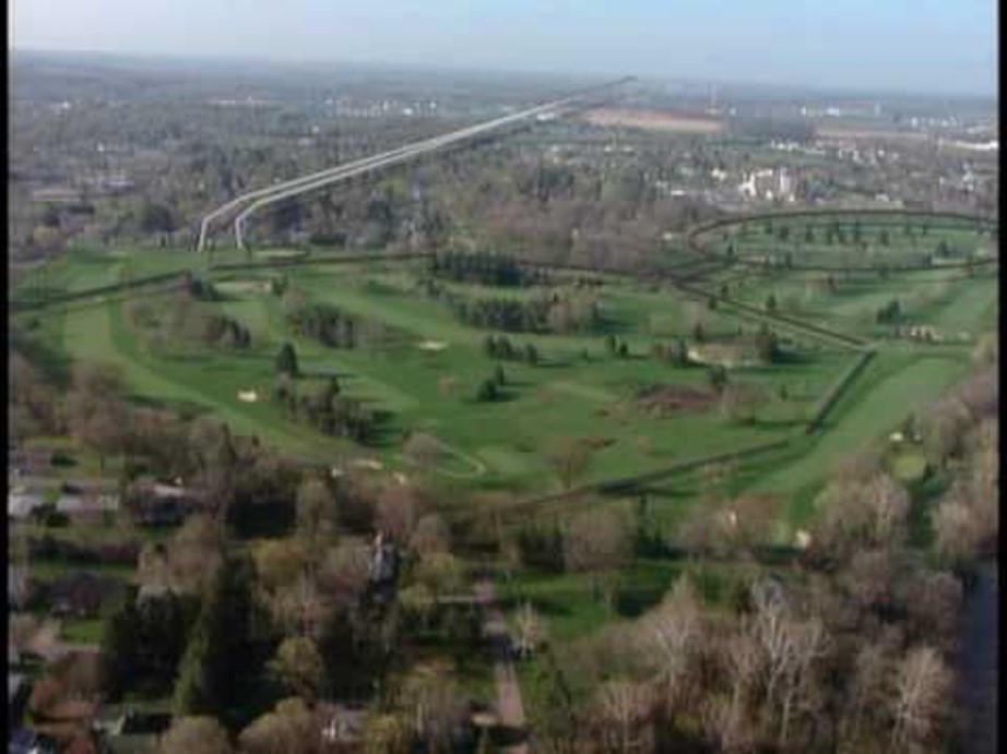
No. 4), which has been very nearly obliterated by the plough. The sections indicated in the engraving are yet quite distinct ; nor can the parts supplied differ very materially from the original lines. Perhaps no work in the State has more decided evidences of aboriginal occupation. The entire area is covered with traces of ancient habitations, and with relics of art pottery, ornaments, and implements. Exterior to the walls, in all directions, but particularly on the level grounds between the two works, the same indications .are abundant. Indeed, the artificial accumulations are so great as materially to augment the fertility of the soil. Caches have been observed here, in some of which the present proprietor of the grounds has found a number of bushels of parched corn, carbonized by long exposure. It is scattered over the surface, and after rains may be collected in considerable quantities. Here, too, have been found skeletons buried according to the usual custom.
The aboriginal population must have been very large at this spot, which, both in respect of soil and the close proximity of springs and pure streams, affords a most beautiful site for an Indian village.
 Mr. Schoolcraft states, on the authority of Le Fort, late chief of the Onondagas, that Ondiaka, the great chronicler of his tribe, informed him, on his last journey to Oneida, that in ancient times, before they had fixed their settlements at Onondaga, and before the Five Nations were confederated, the Onondagas lived below Jamesville and in Pompey ; that in consequence of continued warfare with other tribes, they removed their villages frequently; and that, after the confederation, their fortifications being no longer necessary, they were allowed to fall into decay. This, he believed, was the origin of the ancient works at these points. Notes on the Iroquois, p. 442. Aboriginal Monuments of the State of New York Onondagas County page 35
POMPEY, NY
Source: Onondaga; or Reminiscences of Earlier and Later Times, Vol. II, by Joshua V. H. Clark, A.M., Stoddard and Babcock, Syracuse, NY, 1849, pp. 241-282

You Dig up no more Dead Indian
This [Pompey] was one of the original towns, formed at the first organization of the county, in 1794, and number ten of the Military Townships. At that period it comprised the townships of Pompey, Fabius and Tully, with that part of the Onondaga Reservation, lying south of the Great Genesee Road, and east of Onondaga Creek. The boundaries and area of this town, have been materially diminished since the period of its first organization; so that at the present time, it contains but sixty-eight lots of the one hundred, as laid out in the original township. This township obtained great celebrity abroad, at a very early period, and was principally settled by people from New-England, many of whom took up their residence here, while the township was a part of the town of Mexico, Herkimer County. Mr. John WILCOX was the first white settler on the Township, who came out in the spring of 1789, with an Indian chief from Oneida, for the purpose of exploring the country. He made selection of the lot on which he settled, known as the HASKINS farm, two miles north of La Fayette village. Here was an extensive Indian orchard, and with a view to its improvement, Abel OLCUTT came out the same spring, and made arrangements for pruning it. He spent his nights at the Onondaga Castle, three miles distant, there being no white people nearer than DANFORTH’s or MOREHOUSE’s. He lodged in the cabin of CAWHIEDOTA.  In the prosecution of his labors in pruning, he was surprised that in the center of each and every tree was a collection of small brush, about the size of a bushel basket. Wondering at the singularity of such a circumstance, he inquired of his Indian friend and host the cause, who explained after the following manner: He said, that after the war of the Revolution, the Indian settlement at that place was abandoned, in consequence of the destruction of the corn fields, and a part of the great orchard, by Col. Van SCHAICK, in 1779; that the Onondagas had become completely discouraged, in consequence of the severe losses they had sustained during the war; consequently the Indians, since the war, had not occupied or cultivated any of their lands in that quarter, and the brush he had found collected in the apple-trees, was the work of bears, who ascended the trees in autumn, gathering in the slender branches loaded with apples, with their paws leisurely devouring the fruit, at the same time depositing the branches under them, between the larger diverging limbs, for a more comfortable seat. Sometime after Mr. WILCOX had settled in his new place of abode, his harvests had been abundant, and his stacks of hay and wheat numerous; (for as yet, he had no barns,) every thing seemed to prosper in his hands, but lo, in a single night his cherished hopes were blasted, for some ruthless hand had lighted the torch, and applied it with complete fatality to the gathered treasures of the year. He awoke in the morning only to behold the desolation, and the smoking ruins of his labors, his sustenance and wealth.
The Indians were suspected as guilty of the outrage, and complaint was at once made to the principal chief at Onondaga, who upon investigation, remarked to Mr. WILCOX with the most perfect nonchalance without palliation or denial, “You dig up no more dead Indian, no more will your stacks be burned.” The admonition was sufficient, for although it had been a common practice to rob Indian graves, for the brass kettles and trinkets buried with the bodies; it was from this time discontinued, and the harvests of the farmers were henceforth unmolested.
IROQUOIS ORIGINS NEAR PALMYRA
The Onondaga at the great white pine tree in Syracuse NY on the shores of Onondaga Lake is where the message of peace was planted and the hatchets were buried. Similarly, the Lamanites , “…buried the weapons of war, for peace.” See Alma 24:19
“How America Was Discovered is a story told by Handsome Lake (Seneca Prophet), and documented by Arthur C. Parker, about a young minister who meets the one he perceives to be the Lord, who then asks him to go to a new land and bring with him cards, money, a fiddle, whiskey, and blood corruption. In return the young minister will become rich. The young minister sought out Christopher Columbus, and with the help of his crew, traveled to the Americas. They turned back to report what they had seen, which caused an immigration of people from Europe to the Americas. Along with the people came the five things that aided in destroying the natives. The end reveals that the “Lord” in the gold castle was actually the devil, and that even he knew what he had caused was wrong.” Rudes, B. Tuscarora English Dictionary Toronto
When serving as Mission President to the Seminole Indians in Central Florida, Murray J. Rawson was teaching a group of the tribe about the Book of Mormon when he was interrupted by their Chief, saying: “We had a war long ago with a light skinned people around the Great Lakes. We conquered them but we had so much respect for their warrior chief that we buried him at the mouth of the Oswego River that is in New York State. We don’t discuss this very much because it is an embarrassment to us. President Rawson then asked why this is an embarrassment, and the Chief replied, “ Our history is written on metal plates and buried in a hill in New York, but we don’t know which hill!” (Talk given to missionaries in training at the MTC, Provo, Utah 1979, by President Murray J. Rawson).

IROQUOIS TREATIES
1613 Two Row Wampum or Tawagonshi Agreement (Dutch and French)
1677 Covenant Chain Treaty (English)
1784 The Treaty of Fort Stanwix between the United States and Native Americans. Rome, New York
1788 Phelps & Gorham Purchase with the Iroquois for lands in New York State east of the Genesee River
1794 Treaty of Canandaigua affirming lands rights in New York State east of the Genesee River
1797 Treaty of Big Tree with the Iroquois for lands in New York State west of the Genesee River
“Contrary, then, to widespread assumptions during Joseph Smith’s lifetime that the Onondaga migrated to the New York region, it becomes clear that they originated here as a small, narrowly localized amalgamation of a few villages near Onondaga Lake, during the century before Columbus’ discovery of America” Beauchamp’s Aboriginal Place Names of New York;
Hills and Ruins of Pompey

The first settlers in the present town of Pompey, were Ebenezer BUTLER, from Harrington, Connecticut, who located on lot number sixty-five, in 1792. His brother, Jesse BUTLER, and Jacob HOAR, came on in the spring of the same year. Sally HOAR was the first white child born in this town, and Orange, son of Jesse BUGLER, the first male child. Ebenezer BUTLER died in 1829; he has descendants still living in Ohio. Directly after these first, came James OLCOTT, True Worthy and Selah COOK, Noadiah and Epiphas OLCOTT, the HOLBROOKs, JEROMEs, HIBBARDs, HINSDALEs, MESSINGERs, WESTERNs, ALLENs, BURRs and others, so that neighborhoods began to be formed in many places, as early as 1793 and 1794…
On the west branch of the Limestone Creek, near the mills of the Messrs. PRATT, about two and a half miles north-east of Pompey Hill, is a remarkable waterfall, of about one hundred and sixty feet, which at high water, presents a very grand and imposing appearance. This fall is almost perpendicular, yet enough broken to add beauty to its general character. The chasm below the fall is narrow, deep, abrupt, and the sides much worn. The rock is brown shale…
There are several stone quarries in this town, used for building purposes, mostly dark shale, which are not considered of the most durable or desirable kind. Among these are found petrifactions of oyster, clam and scollup shells, and specimens of trilobite, and other extinct species of crustacea, found in the earliest fossiliferous strata… It may not be uninteresting to the rising generation to be informed, that less than fifty-five years ago, such a vehicle as a horse wagon, was not in existence in this town or county, and the visiting was done mostly in winter on ox sleds; and happy and rich indeed was he who could yoke a pair of oxen of his own, make his way through the woods with his wife and a child or two on the sled, on an evening’s visit to a neighbor’s, several miles distant… At length a beautiful village appears, and is called BUTLER’s Hill, afterwards, Pompey Hill; and there was a time within the memory of many still living, when this same village of Pompey Hill, was as prominent a place as any in the county. It gave more tone to the surrounding settlements, on account of its refinement and wealth, its intelligence and learning, than any place in its vicinity. People came here for legal advice, they came here for medical advice, to do their trading, and they came here for fashions, they came here for military parades, for political discussion, and for general consultations of a public nature; they came here to engage in all the amusements and duties incident to men of a public character…
As the country increased in population, and the forests were prostrated by the woodman’s ax, the beasts of prey yielding the right of possession, retreated into the more unbroken regions, where the dwellings of men were not as frequent. In the town of Fabius, the next town south, an old bear lingered, apparently disputing the right of occupancy, with more tenacity and boldness, than some of his more timorous associates. And not unfrequently did he sally forth in the night, and make forcible entry into the pig pens and carry off some of the younger branches of the swine family, much to the annoyance of the settlers… This occurrence took place in 1802 or ‘3, and is still a story of interest to the descendants of the participators in the scenes of that day….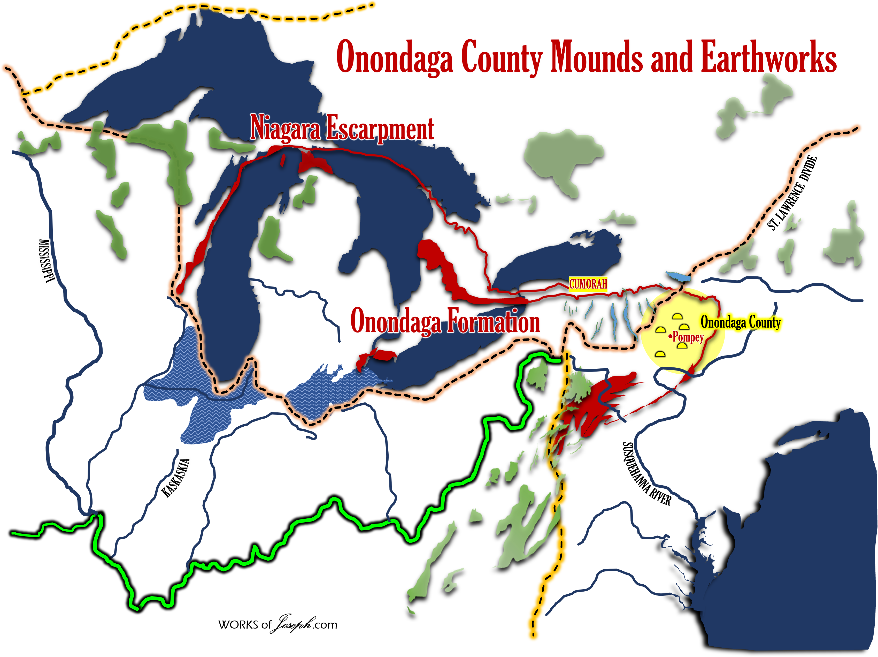
POMPEY HOLLOW, DELPHI
This highly fertile and interesting valley, which borders on the east line of the county, is ten miles in length by about two in width, and contains near twelve thousand acres of land… The land of this valley, like much of that in other parts of the town of Pompey, had to be cleared of heavy timber, consisting of elm, oak, ash, maple, basswood, &c., interspersed with pine, cedar and hemlock. Like the pioneers of all new settlements, the first years of their sojourn were spent under exceedingly great discouragements. They relied, for the first year or two, entirely on provisions brought along with them from the east…
The first frame house of worship in the town of Pompey, was erected by this society in 1807 and ‘8, being the third house of worship erected in the county. The following Rev. gentlemen have occasionally or stately officiated here. Rev. Messers. Rawson, DAVENPORT and BALDWIN, were settled here; Rev. Messers. LEONARD and CHADWICK, and several Baptist and Methodist Clergymen, have occasionally officiated. The Universalist Society now hold and occasionally occupy the house, and furnish a large part of the congregation. The building is apparently fast going to decay.
Dr. Daniel DENNISON first commenced the practice of medicine at this place, in 1814, and is still at his post healing the sick and comforting the dying. Previously, Drs. WARD, WEED. and FISK, of Eagle Village, had officiated as physicians at this place. No lawyer has ever resided at Oran. Messrs. DELAMATER opened the first store of note here about the year 1810, and did a flourishing business…
 A little cast of the village of Delphi, are two very beautiful waterfalls, on the Limestone Creek. They are separated by a deep rocky gorge, of some twenty rods in extent, about thirty yards broad at the top, and not more than eight or ten at bottom, through which the water rushes with great force. The upper fall may be about forty feet in height, and nearly perpendicular, very little broken, and situated as it is among this wild mountain scenery, conveys to the mind an idea of sublimity and grandeur, exciting both wonder and astonishment. The lower full is about fifty feet, and the water leaps over the abrupt and rocky precipice, with a charming mixture of the picturesque and sublime. The high banks of bare dark brown shale, with occasionally an evergreen shrub growing out of the perpendicular precipice, serves to vary the effect, and give life to the boldness and imagery of the scene.
Statistics of Pompey from census of 1845:—
Number of inhabitants, 4,112; subject to military duty, 257; voters, 977; aliens, 36; paupers, 6; children attending Common Schools, 1,029; acres of improved land, 30,951; grist mills, 3; saw mills, 11; oil mills, 2; fulling mills, 1; carding machines, 1; woolen factory, 1; trip hammer, 1; asheries. 1; tanneries, 5; Churches—Baptist, 3; Presbyterian, 3; Episcopal, 1; Methodist, 4; l Universalist, 1; Roman Catholic, private, 1; Academy, 1; Common Schools, 26; Select Schools, 1; taverns, 8; retail stores, 5; merchants, 9; manufacturers, 26; farmers, 775; mechanics, 88; clergymen, 9; physicians, 6; lawyers, 5.
ANTIQUITIES OF THE TOWNSHIP OF POMPEY.
The antiquities of the township of Pompey, consist mainly of earthern forts and defenses—mural remains, traces of villages, trading establishments, burying places and sundry articles found scattered among them. These things, it is our intention briefly to notice.
Indian Hill
One of the most noted localities of this kind, is the one on the farm of Isaac P. JOBS, usually called “Indian Hill.” Upon this spot have been found, perhaps a greater variety of articles, positively indicating the residence, at some early period, of Europeans, than on any other in the vicinity… To the north, is a beautiful slope, extending some thirty or forty rods, when it takes a rapid fall of fifty or more feet. Then a plain of some thirty or forty acres, spreads itself out in full view from the hill. Upon this level were several acres literally covered with graves.
A brass medal was found near this place, in 1821, by John WATSON. It was without date, on one side of it was a figure of Louis XIV, king of France and Navarre. On the reverse aide, was represented a field, with three flowers de luce, supporting a royal crown, surrounded by the name of Nale LANFAR & Co. It was about the size of a Spanish pistareen, had been compressed between dies—characters and letters distinct. It was given to the Hon. Samuel L. MITCHELL, to grace his collection of curious relics and coins.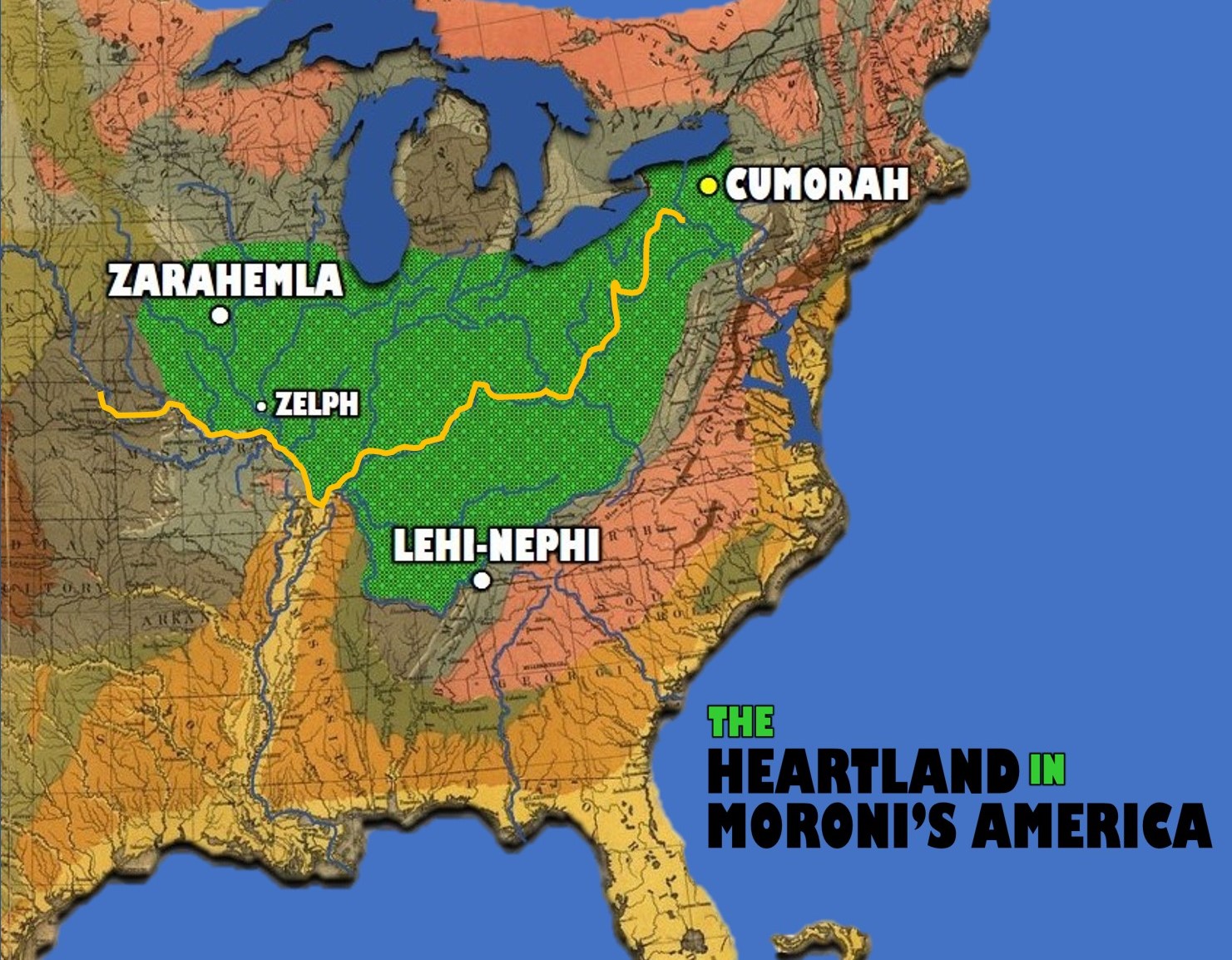
Enclosure entitled “The Fort”
When the first settlers came here in 1791, ’92 ’93, this ground was covered with thorns, wild plumtrees and other shrubs, indicating that it had been cleared and cultivated at some previous time. When it was first cultivated in these latter times, gun barrels, sword blades, hatchets, knives, axes, clay pipes, copper kettles, brass chains, beads of glass, pewter plates, rings for the fingers, ear and nose jewels, lead balls, iron gate hangings, copper coins, tools for working wood and iron, and other articles used by civilized men and unknown to savages, together with human bones, were frequently found on or near the earth’s surface. Many of our early settlers, now living, distinctly recollect the appearance of the enclosure entitled “the fort,” upon and about which, trees had grown to a considerable size. Its earthen walls were then some four or five feet high, having evidently been considerably lessened by the ravages of time. It was circular, and from three hundred to three hundred and fifty feet in diameter. There was but one gateway, and that quite narrow. In 1801, Mr. John HATCH ploughed up three muskets and a blunderbuss. They were found near together, the stocks decayed, the barrels flattened as if with the head of an ax, plainly bearing the indentations of that instrument. There are traditionary notions prevailing with some of the inhabitants in this vicinity, that the mutilation of these arms in this manner was by the Indians who did it that the sound of the guns might not kill them. It is supposed that they were ignorant of the true cause of the weapon’s power of destructiveness. This conclusion is probably erroneous, as nearly all the gun barrels have been found flattened at their muzzles, and the more reasonable inference is, that it was the work of victorious parties who were unable to secure them by removal, and did it to prevent their again becoming useful in the hands of their enemies.
Guns, Copper Coins and Brass Found
The guns usually found, are of a heavy make, with large bell-shaped muzzles; those seen by the author were evidently of English manufacture. The copper coins were French, though so much corroded, that the marks and dates could not be deciphered. Several pits where corn had been stored were visible. In one of these pits a large quantity of charred corn was found. Probably on the breaking up of the establishment, the lodge which contained it was burned over it, and thus prepared the mass for the state of preservation in which it was found. At every plowing something new is brought to light. Not long since a curiously wrought brass chain, two and a half feet long and one inch and a half wide, was found. Its appearance was as if it had recently been subjected to fire, the most prominent parts newly polished. A curious brass image was recently found there, probably a part of some Romish priest’s collection. Many of these relics were found by Mr. JOBS or his workmen, and several are now in his possession. The soil upon this ridge, where undoubtedly once flourished an extensive Indian village, and European trading establishments, has the appearance of rich garden mold recently manured. Large spots of very dark mold may still be seen at regular intervals, a few yards apart, in which are mingled ashes and charcoal, and these, probably, mark the site of the cabins or houses once standing over them. De Witt CLINTON visited this place and others of a similar nature in 1815 or 1816, made many inquiries, and gathered a variety of relics, some of which were presented to the New-York Historical Society. Among them were a small bell without a clapper, piece of a large bell, a gold finger ring, sword blade, bayonet, &c.
Skeletons
There is an extensive burying place contiguous, where several acres were once covered with graves of men, women and children. The skeletons were universally found buried in sitting posture, facing the east, with some domestic utensil or weapon of war between the thigh bones. They are usually found two or three feet below the surface. The skull and bones of the body are uniformly sunk to a level with the legs. From appearances, the bodies, after being placed in their graves, were covered with brush previous to casting the earth upon them. Trees of two hundred years growth, once stood over some of these graves.
This and all the other burying places have been resorted to by antiquaries and others, more curious than considerate, for the purpose of obtaining Indian skeletons. To so great an extent has this rude practice been carried, that perhaps at this time it would be difficult to find one by seeking—as if it could be no harm to rob an Indian’s grave. These noble men have gone; their generations sleep in our cultivated fields; our harvests wave upon their hills; we have robbed them of all else, and we should at least spare their places of sepulcher. Many years ago, when the settlements were first made, a man, whose name deserves not to be remembered, made a regular business of disinterring the bones contained in the Indian graves, to taking whatever was found in them to himself. Hundreds of skeletons have been removed for anatomical purposes, and to enlarge the cabinets of the curious. In this unhallowed business he amassed several hundred dollars’ worth of property. The Indians, who are remarkable for their regard for the dead who, though Pagan in their worship, are shining examples for Christians to follow, in respect to the violation of these sacred deposit, mere at one time on the point of unceremoniously chastising him in a most summary manner. He eluded their vengeance and never dared visit the country afterwards.
Onondaga Castle
There is another place of considerable importance, called “the castle,” near David WILLIAMS’, Pompey, one mile from “Indian Hill.” In former years it was owned by Michael BOURSE, who collected a great variety of trinkets, consisting of beads, precious “stone ornaments,” &c. In 1815, a brass medal was found, on one side of which was an equestrian image with a drawn sword, and on the other, William, Prince of Orange, with a crest or coat of arms; the date was obliterated. William, Prince of Orange, flourished in 1689, and was quite conspicuous in the affairs of New-York for several years previous. This medal may have been a present by him to some distinguished chief. In that neighborhood, a bass wood tree was felled, and an ineffectual attempt made to split the first twelve feet into rails. It was found impossible to open it at all, when, upon farther examination, a large chain was found encircling it, over which one hundred and seventy-eight concentric circles had formed, representing as many years. A large hemlock tree was discovered with three distinct cuts of an ax, over which one hundred and seventy-nine of these granular circles had formed. Now subtract one hundred and seventy-eight from 1815, the time when these examinations were made, and we have the date 1637, as the time when these marks were supposed to have been made, at which time, it is reasonable to suppose, the neighborhood was inhabited by Europeans. A mortar dug out of solid rock may be seen at the brook near by, holding nearly a peck. In the steep banks of this brook are numerous evidences of its having been the scene of a hard fought battle. Articles of war, such as gunbarrels and bullets, have been found, and also knives, axes, &c., upon this particular spot. The regular appearance of four laid out streets for a considerable extent, was once very discernable, and small hillocks where corn had evidently been cultivated could be traced for a long distance. Weapons and implements anciently used by the Indians were frequently found by farmers in plowing their fields, consisting of arrowheads, axes, hatchets, gouges, pestles, &c., made of flint, granite and hornblend, nicely cut and finely polished. David WILLIAMS at one time plowed up the skeleton of a man, and found with it a small brass kettle filled with corn and beans, in a tolerable state of preservation. The kettle was used in his family for domestic purposes several years. A gun barrel was found leaning against a tree, with two-thirds of its top imbedded therein. Wood had made over it about twelve inches. Fragments of the lock were found with it. A box was discovered below the surface of the earth, supposed to have been buried in a hurried manner. It was so far preserved as to show plainly that it had been made of riven planks of ash, partially smoothed with an ax. It contained cloths of red and blue colors; the folds could plainly be seen, and parts were so sound as to admit of being raised without falling asunder. Lead clasps, bearing French marks upon them, were contained in the box.
Samuel HIBBARD and David HINSDALE at one time found a gun barrel on lot number six. They were then boys, and thought to have a little sport. For this purpose they placed the butt end of the gun barrel in the fire, for the purpose of burning off the rust; after a while the barrel exploded and forced a ball against the stone jambs, which completely flattened it. How long this weapon had been charged is unknown, but allowing it to be at the date of other evidences of French occupancy, it must have been near one hundred and forty years. The barrel when found was standing upright in a clump of basswood bushes, as if it had been leaned against a stump which had decayed, and the clump of shrubbery grown up in its stead. Over thirty ivory combs were found near the same place, many of them in a tolerable state of preservation. Wagon loads of old iron have been taken from these grounds.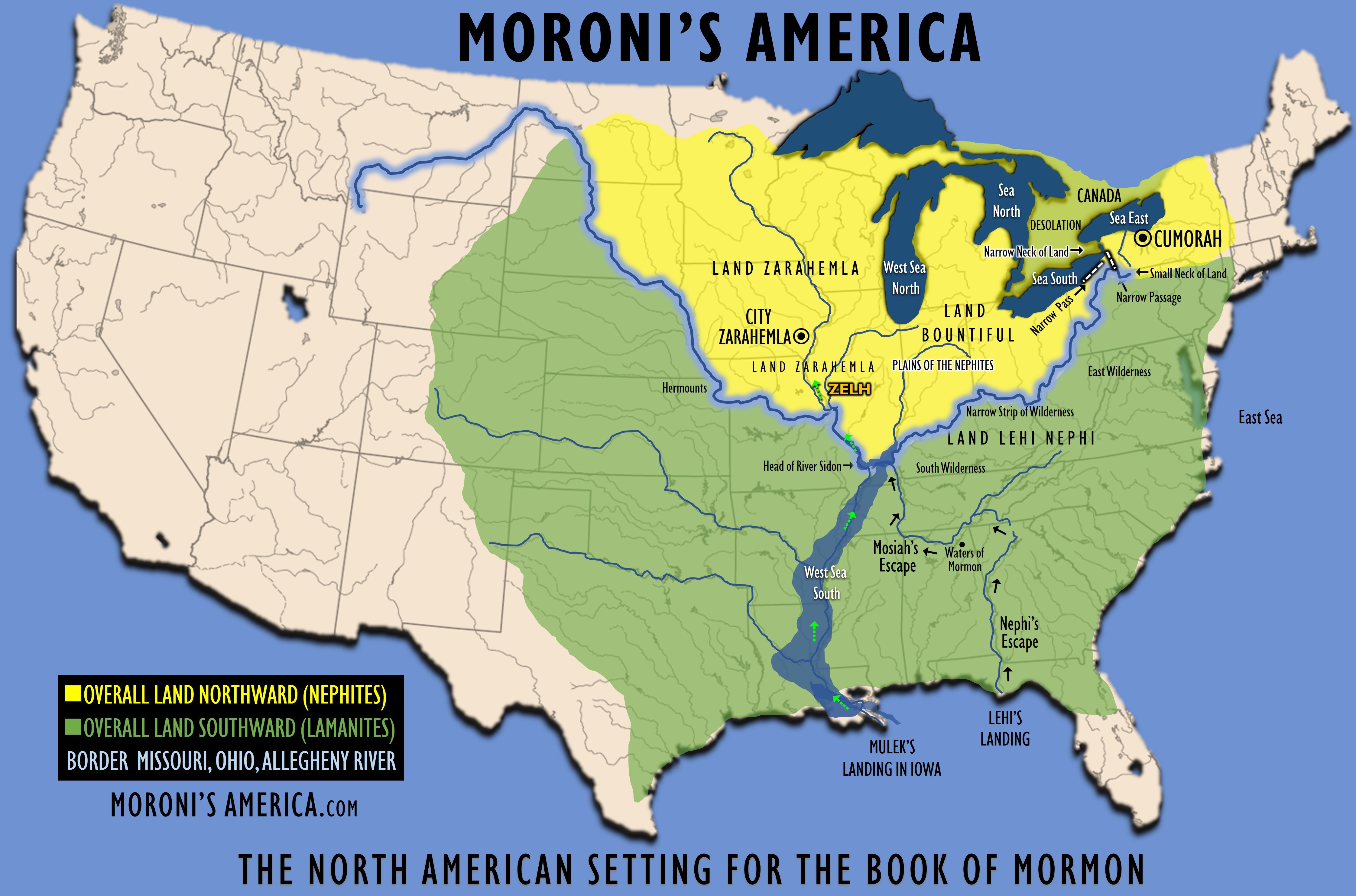
Mr. HINSDALE of Pompey, at one time had in his possession three vises, one of which was very large, and the jaws alone weighed forty one pounds. It was beautifully engraved all over, with representations of dogs, bears, deer, squirrels, fishes, birds, and was altogether a beautiful specimen of workmanship. Another, a hand vise of excellent quality, was sold to Mr. BOYLSTON, a silversmith of Manlius Village, who used it while he continued in the business. Mr. David HINSDALE found a nest of brass kettles, the largest of which would hold two pails full, and the smallest about three pints. They were all bailed, ready for use, and some of the smaller ones were used in Dr. WESTERN’s family, and Mr. HINSDALE’s family, for several years. The larger ones, being on the outside, were considerably corroded by time and exposure, and were unfit for use. When found, they were nearly buried under the roots of a large tree.
The bones of a man were found on the surface, partially covered, and with them part of a case of surgical instruments, much corroded by rust. On the late Dr. WESTERN’S farm, could be distinctly traced the remains of a small fortification, with a burying place. One grave was opened, in which were the remains of thirteen men. One of the skulls taken from it had been perforated by a bullet, which was found within it. Another skull found in this grave was very much larger than its fellows; the under jaw would fit completely outside of a common man’s, and it is said that the other bones were of corresponding gigantic dimensions A vise and other blacksmith’s tools were found here, as well as gate hinges and many trinkets like those already enumerated. Not far from this last, on the farm of the late John CLAPP, at an early day were plainly traceable, the lines of an earthen fortification. Sundry articles, such as musket balls, gun barrels, axes, &c., have been found upon this ground. The axes were usually made from a straight bar of iron, the eye formed by bending it over, welding it down and hammering out an edge; not at all resembling any tool now in common use. Near this place were plowed up, several years since, six large, very deep, heavy, and broad rimmed pewter platters. They were found several inches below the surface, one within another; they are in a very good state of preservation now and plainly bear the impression of the British coat of arms; probably were once the property of a party of English traders and may have been buried there as a place of safety.
In felling a large pine tree for shingles on Mr. HIBBARD’S farm, in 1820, after cutting in about a foot, the mark of an ax was found, and also a burned spot, the size of a man’s hand or larger. The probability is, that the tree had been “boxed” to obtain turpentine, and when the ancient settlement was broken up, the turpentine had been burned out. From appearances, about one hundred and seventy years must have passed away since the ax and fire had set their mark upon this tree. All had grown up solid, and there was no outward appearance of former work upon the tree. On Mr. David HINSDALE’s farm, under a large pine stump, was a heap of ashes and cinders, from which the boys in the neighborhood used to extricate almost every variety of Indian relic.
Tis the Field of Blood.
Near Mr. HINSDALE’s house, when the land was first occupied, and before the plow began its work, there were numerous circular elevations made of stones, some twelve or fourteen feet in diameter, and about eighteen inches high. They were arranged in regular rows, some two or three rods apart, and were probably the foundations of cabins, which had been once erected on this ground, which must from their numbers and extent formed a considerable village. Among the curious relics preserved by Mr. HINSDALE, is a pad-lock of triangular shape, about three inches on a side. It is almost destroyed by rust, but it is a singular piece of mechanism, and must in its day have been quite a formidable opponent to the progress of thieves. He has a knife which has withstood the rust and ravages of exposure and time better than any thing yet found. The steel must be of the finest quality, and high tempered, and might now be used as well as ever if it was provided with a handle. He has numerous beads, specimens of wampum, ornaments of red pipe-stone, medals, rings, crosses, &c. &c., which are well worth the attention of the curious. Several brass crescents have been found bearing the inscription, “Roi de France et Dieu.” These were probably used for nose and ear jewels. Corn hills were abundant near all the places bearing the marks of occupancy before the plow leveled them, and even now in the forests they are to be found, but not so frequently as in former times. The art of making maple sugar was undoubtedly known to the Indians, for the early settlers all agree that the maple trees in this region bore evident marks of having been tapped. Ax marks were often found six or eight inches from the bark, many of the trees being hollow, caused by frequent incisions. Even the marks made by the rude gouges of the natives were sometimes made visible in the operation of clearing off forests.
These places of defense and burial were very numerous in the township of Pompey. There are not less than fifteen which have been pointed out to us, and which we have visited. they are scattered through several of the neighboring towns. We might multiply accounts of these relics without end, but enough has already been said, we hope, to attract the attention of searchers after antiquarian truth, and to show that this interesting section was once partially peopled by Europeans, (probably French, long since the discovery of America by Columbus,) whose history is obscure, and can only be imperfectly unraveled by judicious comparisons and plausible conjecture.
Most of the grounds before noted, undoubtedly have been the scenes of hard fought battles, after which the country was probably deserted by the remnant (if any) of whites who once kept their trading establishments here. Villages to a considerable extent once covered these hills, and the fate of their inhabitants is, and probably for ever will be wrapped in mystery. When, or by what civilized men these fortifications were built, it were vain for us to inquire; obscurity draws her doubtful veil over the whole, and we dimly see in the faded traditions and chronicles of the past, that these were the works of architects not barbarian, at a period not exceedingly remote. Indian tradition still keeps alive the fact that these grounds have been the theatre of blood; and such is their abhorrence of scenes once enacted here, that except in a few very rare instances, they do not visit the regions near the ancient forts and burying grounds. “Ote queh-sa-he-eh” is their exclamation—“’Tis the field of blood.”
By comparing facts and circumstances as they have fallen under our observation with other historical data, and considering the importance the early French colonists of Canada always attached to the Indian trade, the readiness with which they adapted themselves to Indian manners and habits, and the earnest desire of the Jesuits to establish the Romish religion among them, it may not be unreasonable to suppose, that designing men pushed their way here, and made themselves familiar with the country and its resources, long before colonies were established, and individual enterprise may have erected defenses for security, long before they were considered of sufficient importance to claim protection from their government. It should also be borne in mind, that the French had always cherished the design of absolutely monopolizing and controlling all the trade of the Iroquois. Colonies and military posts were established at Quebec and Montreal, during the first twelve years of the seventeenth century, and these were considerably increased during the twenty-five years immediately succeeding.
The Dutch also had opened a channel of trade with the “Maquas,” during the period that they held possession of New-Netherlands; but it does not appear that during their ascendancy, their traders or people formed any permanent residences among the Indian nations west of the Mohawks’ country, although the trade was considered lucrative. And the New-England people it is presumed, had troubles enough to engage all of their attention at home, in the protracted and exhausting wars which occurred during the infancy of their settlements. So that it is but reasonable to infer, that the early French adventurers succeeded in so far winning the favor and affections of the Iroquois, as to be allowed to intrench themselves strongly within their territory, as early as 1640 or 1650, and that these ruins now so famous as antiquarian relics in our county, were the works of their hands.
The most interesting and important relic of by-gone days, and the one which has attracted the most attention, and elicited the most speculative opinions in this region, undoubtedly is the celebrated stone found by Mr. Philo CLEVELAND on his farm, since occupied by the late Mr. Anson SPRAGUE. It is about fourteen inches long by twelve inches broad and eight inches thick; a very heavy, hard, oval shaped stone, evidently a boulder, much worn, and from outward appearances, granitic, but perhaps approaching nearer to gneiss than granite; on it in the centre, is rather rudely engraved the figure of a tree with a serpent climbing it. (See the annexed out.)
Of course the interpretation would be materially different. It was probably designed as a sepulchral monument, and may have been executed on or near the place where it was found.
The following brief history of this singular relic may not be wholly uninteresting. Mr. CLEVELAND was picking stones in his field, preparatory to making a meadow, in the summer of 1820 or 1821. It was on a moist piece of ground and toward evening, at the close of his day’s labors, he raised the stone with his iron bar and turned it on its edge. Mr. C. being weary, leaned against a stump near by, with his hands resting on the top of the bar. While musing in that position, with his eyes fixed upon the stone, he observed something remarkable about it; and upon taking a nearer view, discovered some of the characters and letters above described. He removed it to a pile of stones not far distant, and at the time thought but little of it. Several days afterward he made another visit to the stone, when he found that the rain had washed the dirt clean from it, and the rude engraving was much more distinctly to be seen. This induced him to invite some of his neighbors to examine it, whereupon it was decided to remove it to a blacksmith’s shop at Watervale, a small settlement near by. It remained there six months or more, and became the subject of much talk and speculation at the time.
Every person who came to the shop, would of course examine the stone, take a horse nail or old file and scrape all the cracks, seams and carvings, giving it somewhat the appearance of new work. The stone was found with the inscription downward, about one-third buried. It is not at all probable that Mr. CLEVELAND or any of the persons who first saw the stone in the field or at the shop, could have designed or executed the carvings; besides, there are many persons now living who would bear testimony to its authenticity. It was subsequently removed to Manlius Village, and was visited by several distinguished gentlemen of science, most of whom were disposed to admit that it was genuine. It remained in this village nearly a year, and was finally deposited in the Museum of the Albany Institute, now under the care of Dr. T. Romeyn BECK, where it still remains an object both of speculation and curiosity; and so far as the writer of this is informed, it is admitted to be an authentic memorial of antiquity. The stone and inscription are subjects highly interesting to the lovers of antiquarian lore, and to the curious student.
An attempt to account for, decipher and satisfactorily explain so singular a relic, might seem arrogant in the extreme. A few words will suffice, when we reflect that Mexico had been fully explored and settled by Spaniards previous to 1521, and that those people always manifested an insatiable thirst for gold. Gaspar COTEREAL, a Portuguese, had explored nearly the whole coast of North America, in 1501. The fishing grounds of Newfoundland were well known and occupied by the French, as early as 1505. The French navigator, VERRAZZINI, faithfully examined the shores of the United States, in 1525. DE SOTO’S memorable campaign commenced in 1539 and ended in 1542. He penetrated as far north as the 36th degree of north latitude, and explored both sides of the Mississippi for several leagues. During his travels, it is said he fell in with a party of northern Indians, who had with them a Spaniard taken from the party of NARVAEZ, who had proceeded over much of Florida, ten years before. When these facts are taken into consideration, and the extreme interest then felt by all classes of men, in the development of the resources of the new world, the avidity with which daring adventurers sought the most distant and imaginary sources of wealth; and the avarice, cupidity and desperation of these men, it may not appear incredible, that a party of Spaniards, either stimulated by the spirit of adventure, or allured by the love of gold, or driven by some rude blast of misfortune, may have visited this region, lost one of their number by death, and erected this rude stone with its simple inscription as a tribute to his memory, as early as the year 1520.
On the hill, about one mile and a half south of Delphi, on lot number one hundred, Pompey, are the ruins of an old fort and burying place, occupying about eight acres of land. It is situated on an elevated piece of ground, surrounded by a deep ravine made by two small streams, which pass around it and unite on the north, making the form of the elevation triangular, or more in shape, like a flat-iron with its point to the north. The principal gateway and entrance was at the north point, and a smaller one on the south side. There was a mound or bastion in front of it. The area of this place of defense was enclosed with a ditch and pickets, which can now be traced throughout nearly the whole circumference, as plain and distinctly as if but recently abandoned. At every place where a picket had stood, a slight depression in the earth is distinctly visible. In one instance, a large tree had fallen, and beneath its roots a cavity was exposed, which had every appearance of having, at some previous time, been the receptacle of a post over which the tree had grown, perhaps one hundred and fifty or two hundred years, and left the artificial post to decay beneath its trunk. The timber within this enclosure was of smaller growth than that immediately contiguous, consisting of dwarf plumb trees, thorns, small maple and ash trees, bushes, &c. The ground was covered with grass. In one corner of the fort, were evident marks of a blacksmith’s shop having been once in full operation there, for various tools have been found belonging to the trade, and also a bed of cinders and a deposit of charcoal. Beneath one of these piles were found en cache, a quantity of corn, among which was a quantity of pumpkin or squash seeds, charred, which almost instantly crumbled to dust upon being exposed to the air. A short distance to the south of the fort is the main burying ground, which is quite extensive. One of the peculiarities of this ground, from all others in which we have had knowledge, is that the corpses are buried, one row with their heads to the west and the next row with their heads to the east, so that the feet of the two rows were towards each other, and very near together, with the arms folded across the breast. Many of these skeletons have at different times been removed, disentombed to illustrate science and adorn the cabinets of the curious. The skeletons taken from here, have usually been of a size averaging far above that of common men. Several have exceeded seven feet. Many curious trinkets have been disinterred with these bones, such as arrow-heads, axes, knives gun-barrels, beads, glass and earthen were, &c. &c., similar to like named articles found at other places of defense in this vicinity. Under the head of one of these skeletons, which had been removed from its resting place in 1814, was found a large flat stone, and upon that a plate of lead, which had become completely oxydized, and upon exposure to the air crumbled to dust. Near this head was found an ink horn and a curiously wrought pen, made of one of the small spurs of a buck’s horn, from which it was concluded at the time that the subject must have been a man of education, and his occupation that of a secretary or scribe. Within the fort was a large stone about four feet square, upon which were several furrows in regular lines, two or three inches apart, an inch deep, extending nearly across the stone, similar to those on a like kind of stone near the fortification on lot number thirty-three, on the east side of the Hollow. Whether these are significant of any thing, or only the work of fancy, we have not been able to determine. It is supposed by some to be a resort for sharpening tools, implements, &c., which would seem probable enough, were it not that the stones contain no grit, and the lines are perfectly regular and similar to each other. The indentations denoting the position of the posts or pickets in this work, are about four feet apart, and undoubtedly the interstices were filled with saplings interwoven, so as to make the whole a firm and substantial work of aboriginal defense. The palisades were set in the bottom of a ditch, which the early settlers say was in some places six feet deep, when they first saw it forty or forty-five years ago. This work is mainly now on land which has not been cleared. This work is represented by figure one in the cut. About a mile west from this is the remains of another work of similar character, and two miles north of Delphi, in the town of Cazenovia, on lands owned by Mr. William ATWELL, is another, which is represented in the cut figure two. So common are works of this description in this neighborhood, and so extensive are the depositories of the dead, that the most undoubted evidence exists that a numerous population must have, at some prior period, inhabited here.
There is another site of an ancient fortification on a farm owned by a Mr. SHELDON, lately owned by Mr. Elihu BARBER, about one mile north of Delphi, on the west side of the Hollow. The position, appurtenances, &c., of this locality, so nearly resemble the one just before mentioned, that a particular description of it is deemed unnecessary. It is said, how ever, that when the ground was first plowed a cart or carriage wheel was turned up nearly entire, a circumstance which has not occurred we believe in any other locality. Hills of corn were once distinctly traceable at intervals from one of these forts to the other, nearly the whole distance, which proves this neighborhood to have been cleared up at an early day, as the trees now occupying this ground are supposed to be at least two hundred years old, large and uniform in size, so close together as not to admit at all of cultivation between them.
Under a very large pine tree, which had been upturned by the wind, on the farm occupied by Mr. James SCOVILLE, was discovered a large bed of charcoal, which must have been deposited there, judging from the size of the tree, at least two hundred years before. On his farm, also, was an extensive burying ground, where human bones of extraordinary dimensions, have been exhumed.
Mr. William HASKINS, who was the fifth inhabitant in the township of Pompey, on lot number thirteen, in 1792, says that in first plowing the lands, almost every variety of implement used in agriculture and the common arts, was found in that neighborhood. They consisted of knives, supposed to be of French manufacture, axes, with the English stamp, gun barrels, some of them with a portion of the stock remaining, abundance of ship-spikes, pump-hooks, a spy-glass, trammel and chains, &c. In one instance a large quantity of musket balls were plowed up by the side of a rock. The remains of a wheel barrow, with the irons entire, also anvils and vises, unfinished gun-barrels and gun-locks, hand-saws and files fragments of church bells, &c. On this ground the graves were arranged with great regularity, side by side, in rows of ten or fifteen rods in extent; in the vicinity were other groups of graves, but not in regular order. Upon examination the body appears to have been enclosed in a wooden or bark box. In one grave was found two glass bottles. In plowing, fragments of glass bottles, earthen and china ware were found, and a stone, cut in imitation of a watch.
There is a locality in the town of Cazenovia, Madison County, near the line of Onondaga, on lot thirty-three, township of Pompey, called the “Indian Fort.” It is about four miles south-easterly from Manlius Village, situated on a slight eminence, which is nearly surrounded by a deep ravine, the banks of which are quite steep and rocky. The ravine is in shape like an ox-bow, made by two streams, which pass nearly around it and unite. Across this bow, at the opening, was an earthen wall running south-east and north-west, and when first noticed by the early settlers, was four or five feet high, straight, with something of a ditch in front, from two to three feet deep. Within the enclosure may be ten or twelve acres of land. A part of this ground, when first occupied in these latter times, was called “the Prairie,” and is noted now among the old men as the place where the first battalion training was held in the county of Onondaga. But that portion near the wall, and in front of it, has recently (some six years ago) been cleared of a heavy growth of black oak timber. Many of the trees were large, and were probably one hundred and fifty or two hundred years old. Some were standing in the ditch, and others on the top of the embankment. There is a burying place within the enclosure. The plow has already done much towards leveling the wall and ditch; still they can be easily traced the whole extent. A few more plowings and harrowings, and no vestige of it will remain. There are numerous specimens of dark brown pottery found upon this ground now, and almost every variety of Indian relic has been found about here, some of which are held in very high estimation by the owners. One fact will apply to this locality, that does not we believe to any other of a similar kind. Two cannon balls, of about three pounds weight, were found in this vicinity, showing that light cannon were used, either for defense, or in the reduction of this fortification.
There is a large rock, in the ravine on the south, on which are inscribed the following characters, thus, IIIIIX, cut three quarters of an inch broad, nine inches long, three-fourths of an inch deep, perfectly regular, and the lines straight. When it was a work of fancy or had significance, we have not been able to determine. On the site of the village of Cazenovia, we have been informed, there was a fort or embankment. Some persons say it was “roundish,” others that it was “angular with sides at right angles.” Recollections respecting it are very imperfect. Many relics have been found here, indicating an earlier occupancy than those usually found in this country. This was on the Oneidas’ territory. There is a singular coincidence in the location of the fortifications enumerated, which we have never observed until a recent visit. They are nearly all, if not quite all, situated on land rather elevated above that which is immediately contiguous, and surrounded or nearly so, by deep ravines, so that these form a part of the fortifications themselves. At one of these, (on the farm of David WILLIAMS, in Pompey,) the banks on either side are found to contain bullets of lead, as if shot across at opposing forces. The space between, may be about three or four rods, and the natural cutting twenty or twenty-five feet deep. This goes far to prove the care these architects had in selecting the most favorable situations for defense, and the fear and expectation they were in of attacks. We are of opinion that the fortifications in this neighborhood are not more ancient than the period of the French settlement of missionaries among the Onondagas, during the early part of the seventeenth century. But the more we investigate this subject, the more we are convinced that there were many more of the French established here among the Indians by far, than has been generally supposed, and their continuance with them longer, for it was a leading feature in the policy of the early French Governors of Canada, and of the French nation, not only to christianized the natives by the introduction of missionaries among them, but also to colonize their country. The nature of the articles found, utensils of farmers and mechanics, hoes, axes, horse-shoes, hammers, blacksmiths’ tools, &c., go to prove that agriculture and the mechanic arts, were practiced some that extensively during their sojourn. The Indian name by which the country in and about Pompey was anciently known, we think goes to substantiate this fact, Ote-ge-ga-ja-ke—an open place, with much grass, an opening, or prairie The timber in many places here, has a vigorous growth; and although large, there is a uniformity in the size and age, which shows that it has all grown up since the occupancy, because under the trees are not only found relics, but among them, in many instances, corn-hills can be traced at considerable distances. That the appearance of corn-hills in a wilderness, after a lapse of so many years may appear less strange, it may be well to remark, that the Indian mode of planting, formerly, varied materially from that of the whites. Their manner was to plant three hills near each other and raise quite a mound around them, and plant the same mound for a series of years, and these mounds are the corn-hills noticed at the present day.
Editor’s Note:
The purpose of my information here about Onondagus County NY and surrounding areas is to share with you significant archaeological evidence for the ancient Hopewell Culture nearby the Hill Cumorah which I also believe is the area where the Nephites lived.
There is evidence of fortifications, pottery, copper, weapons, palisades, forts, mass burials, mounds, tools and other artifacts all around this area. I believe the Hopewell culture matches up with the Nephite culture extraordinarily well. The Hopewell originated in 600 BC at the panhandle of Florida from Crystal River to Pensacola, Florida. History documents this. The Hopewell then traveled north into Georgia and Tennessee. There is evidence of a huge society of the Hopewell from Missouri to Illinois to Indiana and then to Ohio which was the dominant historical area of this people. History shows the end of the Hopewell civilization around the year 400 AD. Historians say the Hopewell just disappeared and historians have no idea what happened. I feel I have a good idea. The final battle at Cumorah was 385 AD. This is some of the best evidence of a possible link to the Hopewell and the Nephites.
My friend who is a very loving Christian and Preacher named Richard D. Moats is an Avocational Archaeologist, who has lived in Ohio his entire life and jokes with me and says, “I know the people of Ohio as Hebrews and you know them as Nephites. We have found the same people.” Doesn’t it really make sense that there has to be traces of Hebrew where Lehi and Nephi lived? Search for yourself. Many signs show Hebrew influence in North America and especially in Ohio. It’s sad that many professionals say all the artifacts are a hoax. They have to say that for over 20 various items that have been discovered.
Onondaga; or Reminiscences of Earlier and Later Times continued, “The presentation of medals to the Indians was undoubtedly a very common practice with the missionaries and traders. A valuable cross of gold was several years ago found in the west part of Pompey, and was sold for thirty dollars. The significant “I. H. S.” (“Hominum Salvator, or Jesus, the savior of men”) was upon it. Numbers of crucifixes and crosses have been found. Brass crosses are frequently found, with those letters, and the initials of the latin title put upon the cross at the crucifixion, “I. N. R. I.,” (“Jesuus Nazarenus, Rex Julesorum, or Jesus of Nazareth, King of the Jews”) and so are medals of the same metal. One was recently found, on the farm of David HINSDALE, about the size of a shilling piece. The figure of a Roman Pontiff, in a standing position, in his hand a crosier, surrounded with this inscription: “B. virg. sin. P. origi. con.” which we have ventured to write out, “Beata virgo sine Peccato originali concepts,” or as we might say in English, “The blessed virgin conceived without original sin.” On the other side was a representation of a serpent, and two nearly naked figures, looking intently upon it. This one is very perfect in all its parts, and the letters as plain as if struck but yesterday. It was undoubtedly compressed between dies. It is oval in shape, and bored that it might be suspended from the neck.
A silver medal was found, near Eagle Village, about the size of a dollar, but a little thinner, with a ring or loop at one edge, to admit a cord by which it might be suspended. On one side appears in relief, a somewhat rude representation of a fortified town, with several tall steeples rising above its buildings, and a citadel from which the British flag is flying; a river broken by an island or two, occupies the foreground, and above, along the upper edge of the medal, is the name Montreal. The initials D. C. F., probably of the manufacturer, are stamped below. On the opposite side, which was originally made blank, are engraved the words CANECYA, Onondagoes, which are doubtless the name and nation of the red ruler on whose dusky breast this ornament was displayed, as a valuable token of friendship of some British Governor of. New York or Canada, to an influential ally among the Five Nations. There is no date on this or any other of the medals. But this must be at least older than the Revolution, and probably more than a hundred and fifty snows have whitened the field, where the plow disinterred it, since the chief, whose name it has preserved, was laid to rest with his fathers.
In July, 1840, was found, on the farm of Mr. William CAMPBELL, by his son, on lot number three, La Fayette, a silver medal, about the size of a dollar, and nearly as thick. On one aide is a device, surmounted by an angel on the wing, stretching forward with its left hand, looking down upon those below with a resolute, determined and commanding countenance. Far in the background, is a lofty ridge of mountains. Just beneath and away in the distance, is seen an Indian village or town, towards which the angel is steadily and earnestly pointing. Above this overhangs a slight curtain of cloud or smoke. Between the village and the mountain are scattering trees, as if an opening had just been made in the forest; nearer are seen various wild animals sporting gaily. In bolder relief are seen Europeans, in the costume of priests and pilgrims, with staves, exhibiting by their gestures and countenances, hilarity, gladness and joy, winding their way up the gentle ascent towards the mountain, decreasing in size from the place of departure, till lost from view. Among them are wheel carriages and domestic animals, intermixed. On the right is a fair representation of a cottage, and a spacious commercial ware-house, against which are leaning sheaves of grain. The whole is surrounded by the following inscription in Dutch: GEHE AUS DEINEM VATTER LAND, 1 b. M., XII., V. 1, and at the bottom across, LASST HIER DIEGVTER. On the opposite side there is a figure of the sun shining in meridian splendor, casting its noon-tide rays over a civilized town, represented by churches, stores, dwellings, &c., with various domestic animals, and numerous persons engaged in husbandry and other pursuits. In bolder relief stand Europeans in the costume of the fifteenth and sixteenth centuries, engaged as if in animated and joyful conversation and greetings, and by various attitudes, manifesting happiness and joy. On the right is represented a section of a church, at the door of which stands a venerable man, with head uncovered, with his hands extended, as if welcoming these persons to a new and happy habitation. This side is surrounded by the following inscription: VND DV SOLLT EIN SEEGEN SEYN, 1 b. Mos., XII., V. 2, and across the bottom as follows: GOTT GIBT SIEWIEDER.
The interpretation of the first side is—Get thee out from thy country and friends, thou shalt be truly a blessing. On the reverse side, which should be read in connection—Leaving thy goods behind thee, God will restore them to thee again.
Inscription on the Medal
The small letters and figures on the right, refer to the 1st Book of Genesis, XII chap., verses 1st and 2d, which inscription on the medal was taken from those verses in the Dutch Bibles. Our translation is very excellent, though perhaps not strictly literal, (which see.) It is in this chapter that God calleth Abram, and blesseth him with a promise of Christ; promiseth him the land of Canaan in a vision, to which he departed with his kindred and friends and servants, and there builded an altar unto the Lord. Abram’s first step was obedience. He left all and took possession, with his household, of the land of Canaan; and it is remarkable that the first instance of God’s favor towards him was to renew his promise to give him the whole land of Canaan, in place of the possessions he left behind him, and to make his posterity a mighty nation.
This medal must have been none other than one given by his countrymen in Father-land, to a devoted Missionary, with a party of followers intending to spend their days in America, the land of promise, the fruitful Canaan of modern times, who in the goodness of his heart, bent on doing the work of his divine master, at some early day wandered into the wilds of the Onondagas, set up the cross, (the Bethel of Abram,) and left this memento of his mission in the hand of some Neophyte, which by some unaccountable circumstance has been buried, we know not how long, but now comes to light to prove to us, that the aborigines of our country were a people whose spiritual welfare was regarded as sincerely by the Dutch as by their more ambitious and ostentatious neighbors, the French. It is much to be regretted, that on this and all the other medals, there is no date whereby to establish their particular period of antiquity. This is by far the most singular and interesting relic of the kind which has come under our notice, and goes positively to establish a hitherto doubtful point, to wit, the early establishment of missionaries by the Dutch among the Onondagas.*
* Quere. May not this medal be a relic of the Zeisberger mission of 1750.
The fragments of a bell have lately come under our notice found on the farm of Isaac JOBS, which when whole, would have weighed probably one hundred and fifty or two hundred pounds. The metal is very fine, and from appearance, this article must have been of considerable value. Time and exposure have not changed it in the least. When found, some twenty years since, it was broken up, and the pieces found are enough to make it nearly entire.
On the farm of Mr. Isaac KEELER, were the remains of an ancient fort and burying ground. When Mr. KEELER first settled here, the site of the old fort was an extensive opening of about fifty acres, bearing grass, with clumps of wild plumb trees, and a few scattering forest trees. Mr. KEELER has left some of these plumb trees standing, and has cultivated them, and they yield fruit inferior to none. On this opening it is said, was paraded the first regiment of militia that was organized the county of Onondaga, commanded by Major Moses DE WITT. This ancient remnant of a fort is on lot number three, township of Pompey, and was formerly owned by Moses DE WITT. At that time the outlines of this fort were distinctly traceable. It had been enclosed with palisades of cedar and contained some ten acres of land. The plan was a plain parallelogram, divided across the shortest way through the middle, by two rows of palisades running east and west. The space between the rows was about twelve feet. At the north west corner was an isolated bastion and an embrasure. When first brought under cultivation by a Mr. William BENDS, he plowed up many of the stumps of palisades of cedar which had been burned off level with the ground. Within the southern division of the fort were several mounds, the principal one of which was about four feet high, rising on a base of about fifteen feet diameter, composed chiefly of ashes, in which were found many beads of the size of bullets, and many other trinkets of various sizes and patterns, made of red pipe-stone. Several hundred pounds of old iron have been gleaned from this spot, consisting of axes, hatchets, gun-barrels and locks, coarse files, horse-shoes, large spikes, hammers and blacksmiths tools. The smaller mounds principally contained charred corn, many bushels of which have been plowed up. At a distance of about forty rods north of the north-west corner of the fort was a ditch perhaps forty rods long, running north by west; some parts of it three feet deep, others less; about six feet in breadth; undoubtedly it originally was much deeper. From present appearances, it was entirely disconnected with the fort; but time has made such alterations with it and the grounds around, that at this late day, it is impossible to conjecture for what purpose it was originally intended. The situation of this ancient fort was on an elevation of land, gradually rising for nearly a mile in every direction; and at the time of its occupancy, several hundreds of acres of land in the vicinity must have been cleared, giving to the garrison an extensive prospect. The grounds occupied by the fort are about fifty rods east of Mr. KEELER’s house, and are unsurpassed by any in the county for fertility and beauty of location. Here in ancient times, undoubtedly have been marshaled with nodding plume and rattling cuirass, the troops of the French side by side with the dusky Onondagas, singularly contrasting their polished European weapons with the hickory bows and flint arrows of their allies; and here too have they mingled the war-whoop of the savage, with the Vive le Roi de France; while the Black Robes with their trembling neophytes, chante in ecstacy, Venite Exultemus and Jubilate Deo. Seasons of joy and festivities, of worship and praise to God, passed for years over this land; the trader gathered riches from the wild forester, and the warrior fresh laurels wherewith to entwine his brow. At length a storm arises, the priest, the warrior and the chausseur foresee its portentous gloom, too late to flee the tempest, and too feeble to withstand the shock. They fell victims to its fury, and these few relics are the only evidences of their fate. Fragments of broken pottery, apparently used for culinary purposes, are abundantly found on this location. Pipes, flint arrow-heads, stone hatchets, mortars and pestles, gouges &c., are also found. In 1813, Mr. Isaac KEELER felled an oak tree near the site of the fort, measuring three feet in diameter. In preparing the tree for the fire, a leaden bullet was found covered by one hundred and forty-three cortical layers. It was about four inches from the heart of the tree, which must have been small when the bullet was fired. From calculation, the time which has elapsed since the bullet assumed its position, must be over one hundred and forty-five years, making the date of its lodgment, A.D. 1667.
Brass Compass-Box
Mr. KEELER had in his possession a portion of a brass dial plate, plowed up by him on the site of this fort; on it are engraved in fair Roman characters, I. II. III. IV. V. VI. VII VIII.; also a brass compass-box, from which the needle had been removed, and its place supplied with vermilion, a pigment highly prized by the Indians; and another more perfect one beautifully wrought, having on one side a representation of our Saviour, and on the other, Mary the mother of Jesus as represented in the following cuts:
Also, an octagonal brass medal nearly an inch in diameter, having a figure with the name “St. Agatha,” and the Latin word “Ora,” a part of the Gregorian chant. Also a silver medal half an inch long, with a figure inscribed “St. Lucia” and the same fragment of a chant. Mr. KELLER has also an old balance beam eighteen inches long, which perhaps has often tested the weight of the foot of a Frenchman against the red man’s pound of beaver; for, like the ancient Dutch traders at Albany, it was said the French made a foot weigh a pound. Also a medal of lead, oval shaped, an inch and a half long, with the figure of a man suspended by outstretched hands, supposed to be a representation of our Savior on the cross, and a figure of a serpent. On the opposite side is a figure of a man in a sitting posture, resembling the characteristic position of the native prophets; or as some interpret it, the devil—an emblem that Christianity will destroy all evil. An iron horse shoe, steel corked, with three elongated nail holes on each side. The peculiar workmanship of this shoe, its clumsiness and spread, and the little skill which it evinces in the making, denotes it clearly to be the workmanship of a Canadian blacksmith, precisely like those witnessed at the present day in that country, and intended only for the unferriered hoofs of the Canadian horse. It is the roughest specimen of the craft that can be imagined. This is a specimen of several which have been exhumed in this country, all of which are of the rudest workmanship. Several years ago a curious brass plate probably used for a shield, was plowed up; it was oval shaped, and about eighteen inches in diameter the longest way. Here are also found sword guards, fragments of the blades, gun locks, surgeons’ instruments, saws, bracelets for the wrists three inches broad, of brass highly wrought, and many other curious articles.
 In many places within this fort and in its vicinity, were found numerous pits for hiding en cache, corn and other articles by the occupants from their enemies, or as a temporary place of deposit during their hunting excursions. Skeletons have been found in these places of deposit, some of them of extraordinary size. The jaws of some of them would fit easily over that of any common man. Mr. KEELER has a portion of a jaw in which are double teeth at least one-third larger than those of an ordinary man.
Indian Relics
On Mr. Samuel A. KEENE’s land, are mounds containing human bones; also burying grounds all along on the west side of the creek, on Mr. Jeremiah GOULD’s land, upon which are found almost every variety of Indian relic. On the grounds of Mr. KEENE have been found several strings of very fine glass beads’ of red, blue and white colors, and others striped and variegated; also numerous little bells, such as are sometimes used by the Romish priesthood. Fish hooks have also been picked up in the vicinity of the old fort, and steels for producing fire with tinder. Mr. Keene has a brass compass box, screw top, and a little brass kettle which holds about a pint, all plowed up on his land. Brass crosses have frequently been plowed up, and some of the most perfect and highest finished ones, have over the head of the Saviour, the letters I, N. R. I. Most of the crosses found in other places have the letters I. H. S.
But the most rare and singular relic which has come to our observation, is an iron bombshell, about the size of a six pound ball, weighing two and three-fourths pounds. This was plowed up on the land of Mr. KEENE, and is believed to be the only article of the kind which has been found. Cannon balls of small size have been found in the eastern part of Pompey.
These relics certainly prove that light cannon were in use at these places of fortification. From the great number of gun barrels, crosses, axes, &c., found about here, it is certain that armed bodies of men in considerable numbers, have occupied these grounds; and that from the mutilated condition of the-guns, the broken axes, jammed kettles, and injured state of every thing contributing to defense and-comfort, they must have been exterminated or forcibly driven away. That these are the remains of the French Jesuits and traders of the seventeenth century, there is not a doubt. Everything goes to substantiate the fact. Enough of their history has been related in the foregoing pages, to settle the question beyond dispute. The forts, relies, utensils, mounds, caches, burying grounds, &c., are similar in every direction, and bear marked evidence of former occupancy by man in a civilized state, and in a former age. Like evidences occur also in De Witt, Camillus and Manlius. Were all the records in Christendom totally destroyed, there still remains the most unquestionable evidences of the presence of civilization in this land, in the metallic arms, implements and utensils of the soldier, the artisan, the mechanic and farmer, succeeding a more rude era, in which arts, agriculture and war were carried on with implements of wood, stone, clay and shells.” Submitted by Carl Hommel, October 2, 1998 Source: Onondaga; or Reminiscences of Earlier and Later Times, Vol. II, by Joshua V. H. Clark, A.M., Stoddard and Babcock, Syracuse, NY, 1849, pp. 241-282
https://archive.org/download/cihm_51018/cihm_51018.pdf
Return to Town of Pompey pageReturn to Onondaga County USGenWeb page.
[…] See my blogs about Pompey NY Artifacts here and about the Onondaga Indians which I call the Natives of Joseph Smith […]
Comments are closed.