Bluff Point Ruins/Jerusalem New York
“Of all the Native American sites found in Yates county the “Bluff Point Ruins” are the most mysterious. Two surveyors Berlin H. Wright and Samuel H. Wright, a father and son, discovered this site. Both men accomplished many remarkable things during their lives. Their reputations as highly educated, thoughtful men gives credence to their account of the strange arrangements of stones found on the top of the hill high above the shores of Keuka Lake. Samuel H. Wright wrote an extensive account of the plants and animals found in this area in William Stork’s book A Student’s Handbook of Yates County. Berlin wrote a very accurate description of the geology of the county in the same book.” Bluff Point Ruins
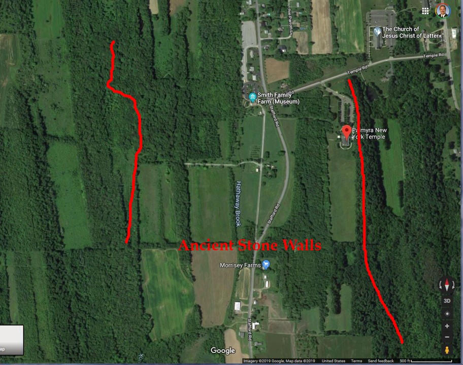
The Bluff Point ruins are only 30 miles south of Hill Cumorah near a small city named Jerusalem, NY. It is also only about 35 miles from Fayette N.Y. where the Prophet Joseph Smith and Oliver Cowdery finished translating the plates. 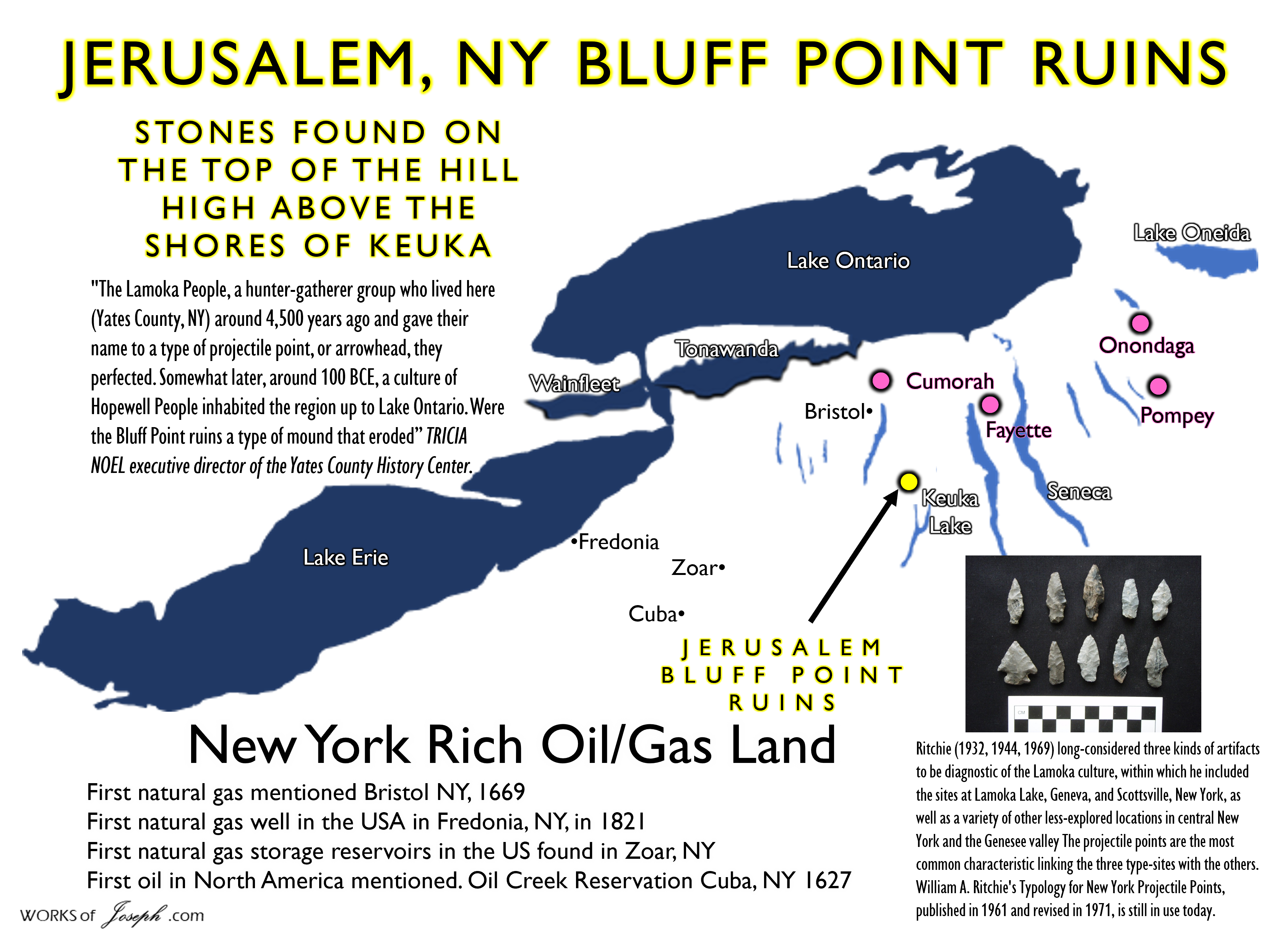
A good friend of the Heartland and myself, David Read sent me the article below titled, “Mysterious Ruin at Bluff Point” which I have enjoyed very much. It continued my research in the New York area. Anything near Hill Cumorah and Palmyra is a lot of fun to investigate. Did you know the first Natural Gas and Oli was found in New York just 100 miles south of Cumorah near Cuba, NY and 130 miles southwest of Cumorah near Fredonia, NY. See Map above for locations.
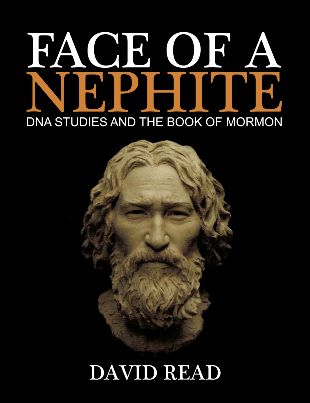 Be sure and read David’s book, it validates Book of Mormon and Nephite DNA in my opinion.
Important DNA evidence has been in front of scientists and researchers for years but only now is being examined and interpreted seriously now. For Latter-day Saints who have grown concerned about apparent anachronisms presented by DNA science the Book of Mormon, this treatise “Face of a Nephite” by Judge David Read, a former patent attorney trained in a wide array of scientific fields, gives readers a close-up and clear re-examination of the evidence and sets the record straight.
Face of a Nephite by David Read, JD Patent Attorney New DNA Studies and the Book of Mormon 110 Pages; Full Color interior
Hopewell/Nephite Battles and the Importance of NY Archaeology
“The battles are described as often having culminated in the destruction of previous, superior Native cultures which had taken final refuge in forts at the tops of hills, including the general region of the hill known to Mormons as Cumorah. In the town of Camillus, in the same county of Onondaga . . . there are two ancient forts . . . One is on a very high hill, and its area covers about three acres. . . . The ditch was deep and the eastern wall ten feet high. In the centre was a large lime stone of an irregular shape.” A Memoir on the Antiquities of the Western Parts of the State of New-York, Addressed to the Honourable Samuel L. Mitchill, a Vice-President of the Literary and Philosophical Society of New York . . . by Dewitt Clinton . . . Read Before the Society November 13th, 1817 De Witt Clinton (1769-1828)
“How America Was Discovered is a story told by Handsome Lake (Seneca Prophet), and documented by Arthur C. Parker, about a young minister who meets the one he perceives to be the Lord, who then asks him to go to a new land and bring with him cards, money, a fiddle, whiskey, and blood corruption. In return the young minister will become rich. The young minister sought out Christopher Columbus, and with the help of his crew, traveled to the Americas. They turned back to report what they had seen, which caused an immigration of people from Europe to the Americas. Along with the people came the five things that aided in destroying the natives. The end reveals that the “Lord” in the gold castle was actually the devil, and that even he knew what he had caused was wrong.” Rudes, B. Tuscarora English Dictionary Toronto
Pompey in Onondaga County, NY
“Pompey in Onondaga County, a town covering upwards of five hundred acres must have contained a population greatly transcending all our ideas of credibility . . . This town was on elevated ground, . . . and was well calculated for defense. . . . There are three old forts distant about eight miles from each other, and forming a triangle which encloses the town; . . . and they were, in all probability, erected to cover the town and to protect the inhabitants from the attacks of an enemy. . . . On the line of the north side, the town was probably stormed. There are graves on each side close to the precipice; sometimes five or six persons were thrown promiscuously into the same grave. If the invaders had been repulsed, the inhabitants would have interred the killed in the usual places; but from the circumstance of there being graves near the ravine and in the village, I am induced to believe that the town was taken. (noting ‘gun barrels, axes, hoes and swords . . . all over these grounds’) The traditions of the Indians agree in some measure with the French relations. They represent that their forefathers had several bloody battles with the French . . . There is a hill in Pompey, which the Indians will not visit, and which they call Bloody Hill.
. . . The old fortifications were erected previous to European intercourse. The Indians are ignorant by whom they were made; and in the wars which took place in this country, it is probable that they were occupied as strong holds by the belligerents; and it is likely that the ruins of European works of a different construction may be found… it is remarkable that our ancient forts resemble the old British and Danish. The Bloody Hill site dated by modern archaeology to ca. 1420 A.D. has been excavated carefully in modern times, yielding comparatively superior ceramic artifacts. Significantly more Native sites are now recognized in Pompey, beyond the few which [DeWitt] Clinton knew or was able to visit.” (James A. Tuck, 104-119) Mormon Parallels: A Bibliographic Source 2014 Rick Grunder page 403. Map from “Onondaga Iroquois Pre History A Study in Settlement Archaeology” James A. Tuck 1971 page 20
Joseph Smith in Onondaga County NY
“Onondaga was a name that Joseph would have heard frequently in the Indian lore which B. H. Roberts felt must have influenced Joseph during his early days in Palmyra… Indeed, in order to reach Palmyra in company with Lucy Mack Smith and his siblings when they emigrated from Vermont, Joseph had to traverse the important township of Onondaga, through which the original Genesee and Seneca Turnpikes still run today…” Mormon Parallels: A Bibliographic Source 2014 Rick Grunder pg. 1125
“Contrary, then, to widespread assumptions during Joseph Smith’s lifetime that the Onondaga migrated to the New York region, it becomes clear that they originated here as a small, narrowly localized amalgamation of a few villages near Onondaga Lake, during the century before Columbus’ discovery of America” Beauchamp’s Aboriginal Place Names of New York;
Iroquois Nation Principle Tribes: Onondaga, Mohawk, Oneida, Seneca, Cayuga, Tuscarora
“The Onondaga at the great white pine tree in Syracuse NY on the shores of Onondaga Lake is where the message of peace was planted and the hatchets were buried. Similarly, the Lamanites , “…buried the weapons of war, for peace.” Alma 24:19
Ganargua Creek (Mud Creek) was a primary stopover point for the Iroquois on their trade routes. Joseph Smith also had an interest in the creek after hearing a speech from Seneca Indian Chief Red Jacket at Palmyra in 1822.
Many historians believe that Iroquoian ideas of federalism, and balance of power directly influenced the US system of government. Benjamin Franklin admired native American government structures. In 1744, Canassatego advocated in Washington the federal union of the American colonies.
The Onondagas: These have special interest… this warrior, Zelph, was an Onondaga, as well as a “white” Lamanite, and that the Onondagas (of New York), consequently must be of Lamanite lineage.” J.M. Sjodahl, An Introduction to the Study of the Book of Mormon
I am Related to the Mohawk Tribe of New York, the Haudenosaunee People.
On June 22, 2024 I was speaking to Delores Kahkonen a great friend and a Native American from the Cayuga Tribe of the Iroquois in Canada. She is the one who has found over 11,000 names and has had the work done by many volunteers for the original 85 Native Chiefs records from the St George Temple. Blog here:
Delores mentioned to me, that most often anyone who works with her on a personal basis with doing temple work has seemed to be related to her. I quickly asked her, Well, here are my mother’s and father’s record numbers, could I be related to you? She got on her Family Search tool and quickly found out, indeed, I was related. I was so overwhelmed with joy I got large goosebumps all over. When continued to share with me the folliwng names who I am related to. I am so blessed.
My Native American Descendants
War captain Audience Arie Kanaghowende Hill
Male 1660 – 1740- G2KS-HYD
Mohawk, War Chief Aaron He Carries A Knife Of The Hill Oseragighte Kayandontyr, Hill
My 5th cousin seven times removed
Male 3 March 1707 – 1772- ID# LKQJ-R4G
Male 28 December 1735 – 1796 ID#LKQJ-1ZG
Mohawk, War captain Audience Arie Kanaghowende Hill
The husband of my 4th cousin eight times removed
Male 1660 – 1740– ID#G2KS-HYD
A Mohawk is one of the Six Nations Confederacy in New York or the Iroquois/Haudenosaunee. Other tribes, Onondaga, Oneida, Cayuga, Seneca, and Tuscarora.
Mormon Buried? Mouth of the Oswego River
Chief of Seminole Tribe: “We had a war long ago with a light skinned people around the Great Lakes. We conquered them but we had so much respect for their warrior chief that we buried him at the mouth of the Oswego River that is in New York State. We don’t discuss this very much because it is an embarrassment to us. President Rawson then asked why this is an embarrassment, and the Chief replied, “ Our history is written on metal plates and buried in a hill in New York, but we don’t know which hill!” (Talk given to missionaries in training at the MTC, Provo, Utah 1979, by President Murray J. Rawson).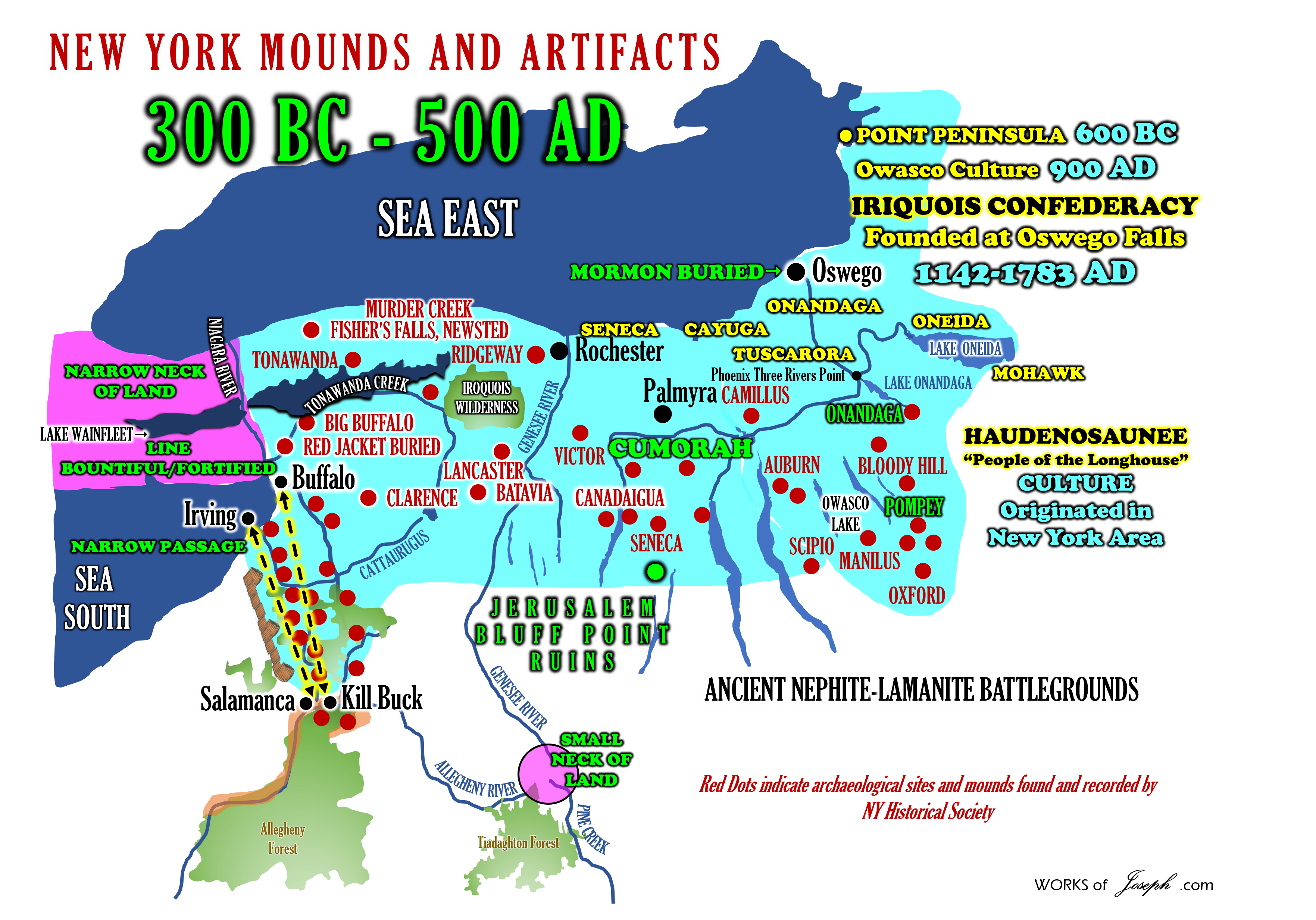
LOOKING BACK: The mysterious Bluff Point ruins of Jerusalem
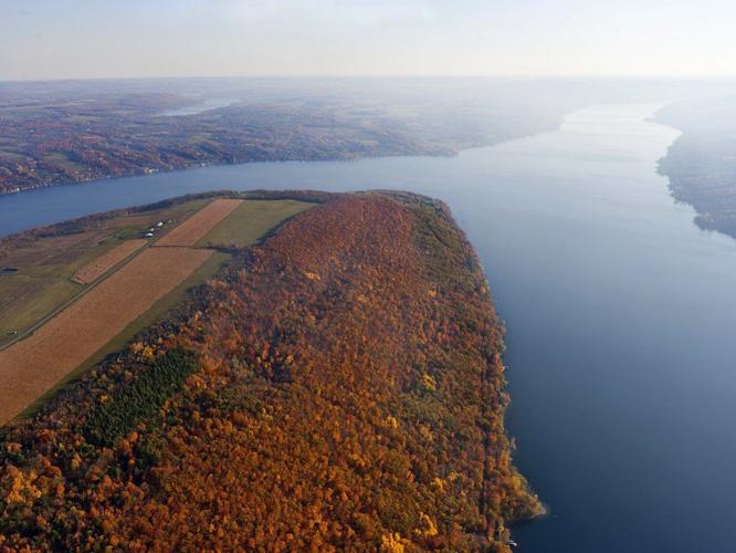
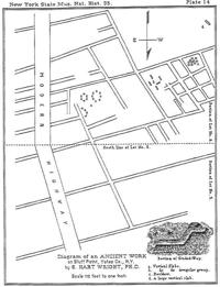
Dr. Samuel Hart Wright — a Yates County doctor, teacher, farmer and botanist — decided to document the unusual Bluff Point ruins in 1879.
Bluff Point has a remarkable past. Part of the distinctive landscape carved out by glaciers, Bluff Point was at one time an island due to high lake levels, remaining so for about 300 years. Eventually the lake receded and Bluff Point recovered its status as a peninsula. In addition, as western New York became more populated after the Revolutionary War and county and town boundaries changed, Bluff Point was once a part of Ontario, then Steuben, and finally Yates County.
The Seneca Nation joined the Cayuga, Mohawk, Onondaga and Oneida nations to form the Haudenosaunee (or Iroquois) Confederacy by 1450, although some historians point to a date as early as 1143. The Tuscarora Nation joined in 1722 to complete the Six Nations. The Seneca were the most populous of the nations; they had villages extending along the western corridor of Haudenosaunee territory, earning them the title “Keepers of the Western Door.” Seneca settlements existed in Yates County, notably at present-day Branchport; the site of Indian Pines Park in Penn Yan; Kashong on the western shore of Seneca Lake; Shearman’s Hollow; and, of course, on the Bluff. Additional communities were lived in for shorter periods or used only during certain times of the year.
See my blogs about Pompey NY Artifacts here and about the Onondaga Indians which I call the Natives of Joseph Smith
Non-native people began moving into present-day Yates County in 1788. Those who purchased land on the bluff noticed unusual ruins that indicated an early, and elaborate, stone works. No one was able to determine the original purpose of the ruins. Some of these early settlers spoke to Seneca remaining in the area, who stated the ruins were not of Seneca origin and had been there longer than they. In fact, they purposely avoided the area.
Sadly, many of these newcomers used the ruins to mine stone needed to build houses. John Finch purchased the lot in 1813, then sold it to Howland Hemphill in 1830, who used some of the stones for his home. Abraham Wagener, the founder of Penn Yan, was rumored to have used a great number of the stones for the foundation of his house on the tip of the Bluff, built in 1833. No doubt many smaller abodes and even barns were built with stones from the ruins.
A mathematical precision
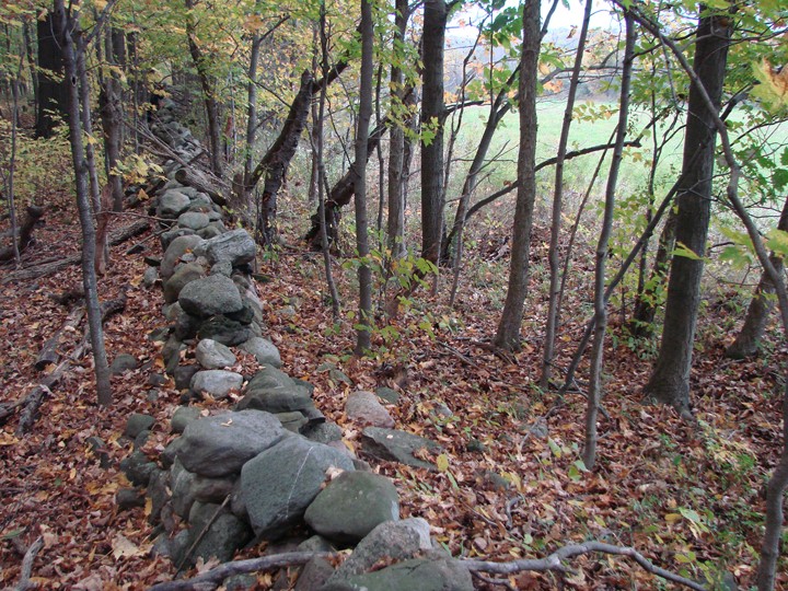
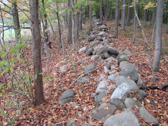
By 1879, Dr. Samuel Hart Wright — a local doctor, teacher, farmer and botanist — decided to document the ruins. Wright was joined in his site inspection by his son, Dr. Berlin Hart Wright, an amateur archaeologist, geologist and early proponent of evolution. Hemphill was still around and reiterated that the Seneca believed the ruins predated them. Although much had been disturbed, it is fortunate that Wright described and drew what he saw. He sketched the area and wrote up his findings in the 35th Annual Report of the New York State Museum of Natural History.
He described an area of seven acres, running from the ridgeline to the west. He focused on what he called “graded ways,” [Ancient roadways of the Nephites?] pathways running through the site that were as wide as eight feet in some places and a foot high. According to Wright’s sketches, these pathways ran in an almost grid-like pattern, punctuated by large, Stonehenge-like vertical slabs and circles of boulders. The areas inside the vertical slabs were floored with more slabs. Declaring he had never seen anything similar, Wright stated that the Bluff Point Ruins were “one of the strangest structures in the state.” He marveled over their mathematical precision. The map Wright sketched depicts a composition of rocks and pathways that do not occur in nature. More than half of the original site had been disturbed by plowing and other agricultural practices. It may have originally been up to 20 acres large.
Decades later, in 1938, reporter Gilbert Brewer excavated the ruins. The graded ways Wright described were determined to go at least 10 feet under the surface, leading one to believe they may originally have been walls that have been partially buried over time. Brewer wrote of his findings: “Bedrock quarried to a depth of 10 feet; arches were of sandstone, the bases of which were set into the cut bedrock; stones engraved with human and animal heads, along with iron objects with similar ornamentation; one iron object with ‘granular’ ornamentation and another with a red enamel design; broken metal platter; a metal detector indicated the presence of stoneware including hammers, pounders, polishers, mortars and pestles, and fragments of a ‘seal’; among the images of humans, that of a woman was the most frequent.”
Sadly, more and more of the Bluff Point Ruins disappeared under the erosion of humans. Telephone lines cut through the site. Skyline Drive was built over a portion. Vineyards and ditches obliterate any visible traces. But although none of it is visible on the ground today, there are likely more fascinating treasures below the surface.
The question remains: if the Seneca were not responsible for this elaborate construction, who was? Wright cast doubt on it being the work of Native Americans, although he begrudgingly admitted it could have been crafted by mound builders, who were responsible for incredible, complicated mounds in the Midwest. Over the decades since the Wrights first recorded the ruins, those interested in the site have floated ideas. Some, like Brewer, believed it bore similarities to Etruscan work. Early Roman visitors, Norsemen wandering through North American, and ancient Celtic travelers have all been theorized as the builders of these ruins, whatever they may have been.
Although it is tempting to find similarities amongst the ruins and types of carvings or concentric circles found in other cultures, these ruins were built by pre-Seneca natives.
Not much is known about cultures in this region before the advent of the Seneca, although we know of the Lamoka People, a hunter-gatherer group who lived here around 4,500 years ago and gave their name to a type of projectile point, or arrowhead, they perfected. Somewhat later, around 100 BCE, a culture of Hopewell People inhabited the region up to Lake Ontario. Were the Bluff Point ruins a type of mound that eroded?
Until an excavation is done, it is impossible to say when the ruins were constructed, and by whom. Until then, the mystery continues.
Noel is the executive director of the Yates County History Center.
Mysterious Ruin at Bluff Pointby David D. RobinsonThere is no trace above ground today of the elaborate, extensive, grid-patterned ruin of the Celtic-like “village” that was once situated on Bluff Point above Keuka Lake. The ruin is on Skyline Drive, about four miles south of Keuka Park, New York, which is just off Route 54-A. On the Yates County highway map, Keuka Park is marked “Site of Primitive Mound Indians.” There are two mounds on Skyline Drive, one quite close to the ruin site and directly north of it. Detailed reports of the ruin come principally from only three sources that I can find: The geological survey was made by Dr. Samuel Hart Wright, MD, who also held an MA degree from Williams College, was a land surveyor, and an internationally recognized biologist. He was assisted by his son, Berlin Hart Wright, MD. One of the first owners of the land, Howland Hemphill, who lived on the site for 50 years, is mentioned by Berlin Hart Wright: “Mr. Hemphill was an aged man at the time of our survey. He said he came to the farm as a young man when the Indians were all about. In answer to a question…he was informed that. ..(the ruin)… was there when the earliest tribesman came to the region.” The 1938-1939 excavation by many persons was carried out under the direction of a newspaper reporter from Canandaigua, New York, Mr. Gilbert T. Brewer. The general appearance of the site did not seem to have changed much from 1880 until as recently as 1954 when the author A. Glenn Rogers visited there and wrote a brief account of it. I am sorry to report that by 1985, and probably a decade or two earlier, the above ground remnants of the site had been almost completely obliterated by vineyards, drainage ditches, hay fields, farm work roads and a pine plantation. Inside the pine plantation are two or three shallow depressions with several mounds of earth next to them, probably all the remains of the 1938-1939 excavation. The schematic ground plan of the site made from the 1880 land survey covers 13 acres of the ruin. The ruin was usually described as being between 14 and 20 acres in extent. The plan shows seven principal walls running roughly NW – SE, one short wall running N – S, and 12 principal walls running roughly NE – SW. At the time the survey was made, Dr. Wright reports that the land in Lot 5 (the northern five acres) shown on the plan had been plowed, and some detail there was surmised by the Wrights from surface rocks. The southern eight acres (in Lot 6) had never been plowed, was unforested, and much detail was visible, as is obvious from the plan and from written reports. Among other things, the 1880s plan shows ten “rooms” that, had they been roofed over, might have been dwellings or storage rooms, generally about 30 x 40 feet or slightly larger. There are also four still larger “rooms” that might have been enclosures, for what, is unknown, and two enclosed areas that might have been for ceremonial purposes. One of the latter might have been a large antechamber. The other seems to have enclosed two stone circles each with a diameter of about 30 feet, and a segment of a third circle of similar size. Most of the rest of the ruin seems to have consisted of walls which might have enclosed fields. Except for their size and regularity, the “fields” are not unlike prehistoric and medieval farming fields, consisting of long, relatively narrow strips separated by stone walls. English archeologists call such fields “Celtic Fields.” No one had reported burials in connection with the site. An account written by Berlin Hart Wright in 1880, or shortly thereafter, states in part, “The remains of the ancient structure consisted of the foundations of the walls, in the form of graded ways three to eight feet wide and one to two feet high, bordered with a vast number of large, flat stones set in the ground edgeways, these stones leaning inward toward the center of the ways. At points of intersection of some of the walls, depressions indicated posts had been standing there at one time, evidently supporting a roof.” ( See Blog here called Earth & Wood Buildings/Hidden Cities/Great Hopewell Road/Graded Ways by Rian Nelson Dr. Wright’s account published in the 1884 Thirty Fifth Annual Report of the New York State Museum of Natural History, by the Regents of the University, pages 193 and 194 states: “All the areas between these ways are depressions, in which water remains until evaporated, the nearness of the rock below, often being only twelve or fourteen inches, prevented its absorption. These areas, or many of them, contain bogs of carex, and some grass, but in the summer are dry and afford a fair pasturage. The dirt used to make the ways was taken from these areas causing the depressions, and the rock beneath was no doubt at that time completely laid bare and furnished the flat stones that are set in on each side of the graded ways.. .No trees are in the structure except a few young ones.” |