
Traveling the Rivers of the Nephites
After Lehi’s travels from Jerusalem to Oman, I believe the Book of Mormon Events began in North America as many prophets and leaders have taught. There are Lamanites in North, South, and Central America through migration, intermarriage and other circumstances. However, through much study research, time, and prayer it makes most sense to me that Lehi landed in Florida and Nephi leaving his brethren, ended up in northern Georgia and Tennessee. Mosiah left Tennessee and went to Iowa and Illinois to join the Mulekites who were already in those areas.
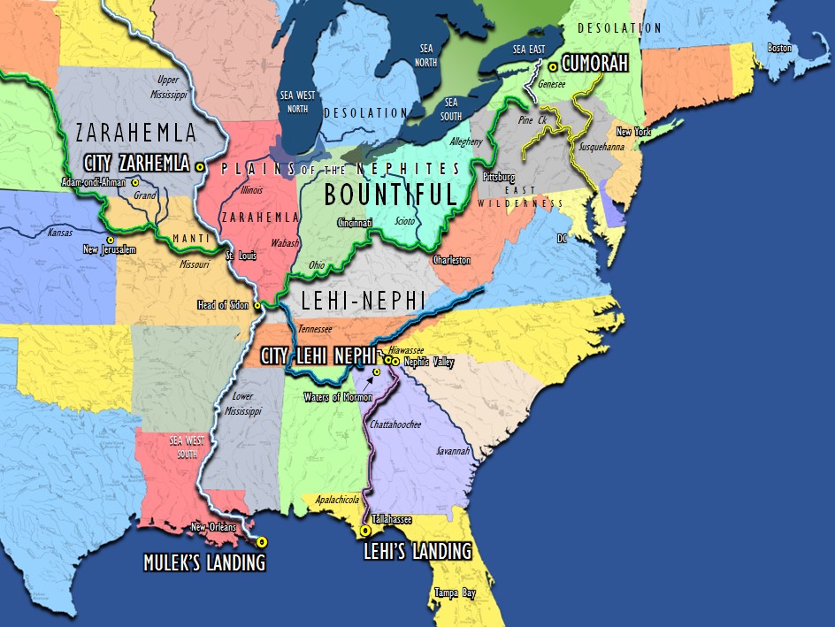
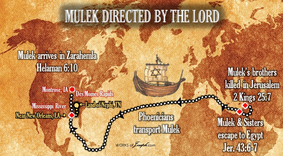
I feel it is very likely that the Mulekites came up the Mississippi River near the Louisiana mounds I speak about below. The main reason I feel that way, is it says in Omni, the Mulekites had been the same place where Mosiah found them the entire time. “There”, in Onmi, would be defined as near the Mississippi River somewhere between Keokuk, IA and Montrose, IA where we feel the Land of Zarahemla is located.
You can also see the similar paths the Lord may have brought Columbus, Lehi, and Mulek on the map below.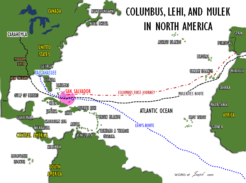
15 Behold, it came to pass that Mosiah discovered that the people of came out from Jerusalem at the time that , king of Judah, was carried away captive into Babylon.
16 And they in the wilderness, and were brought by the hand of the Lord across the great waters, into the land where Mosiah discovered them; and they had dwelt there from that time forth.
17 And at the time that Mosiah discovered them, they had become exceedingly numerous. Nevertheless, they had had many wars and serious contentions, and had fallen by the sword from time to time; and their had become corrupted; and they had brought no with them; and they denied the being of their Creator; and Mosiah, nor the people of Mosiah, could understand them.” Omni 1:15-17
Because they had become numerous, I am confident there would have been people all up and down the Mississippi from New Orleans and above into Wisconsin and Minnesota. Groups who fight and flee would always find an area where they could live in peace.
Knowing any information about the Book of Mormon is important to me, as Moroni has said “ye may know the truth of all things.” I have received many personal answers to questions of secondary importance to my spiritual confirmation that the Book of Mormon is true and Joseph translated it using the Interpreters as he said in JSH 1:35, and not by using a silly, in my opinion, stone in a hat. I agree with Joseph Fielding Smith’s wonderful quote when he said, “Because of this theory [Mesoamerica] some members of the Church have become confused and greatly disturbed in their faith in the Book of Mormon.” Doctrines of Salvation Joseph Fielding Smith Chapter 12
Varying Opinions
As my friend Wayne May suggests, the Mulekites may have taken the St Lawrence northern route and followed the Great Lakes toward Detroit and ending up in Iowa. I just feel that would be a difficult route with the harsh flowing direction of the St Lawrence, the barrier of Niagara Falls, and not having a direct route from Detroit to Iowa on the Mississippi. It seems to me they would have had to stop several places along the way. Of course it is up to you to decide.
Wayne, Rod, Boyd, David, Jonathan and I as editors of the Annotated Book of Mormon, have differing opinions which we think is healthy. We enjoy bantering back and forth as none of us know for sure, but we enjoy sharing our theories with each other.
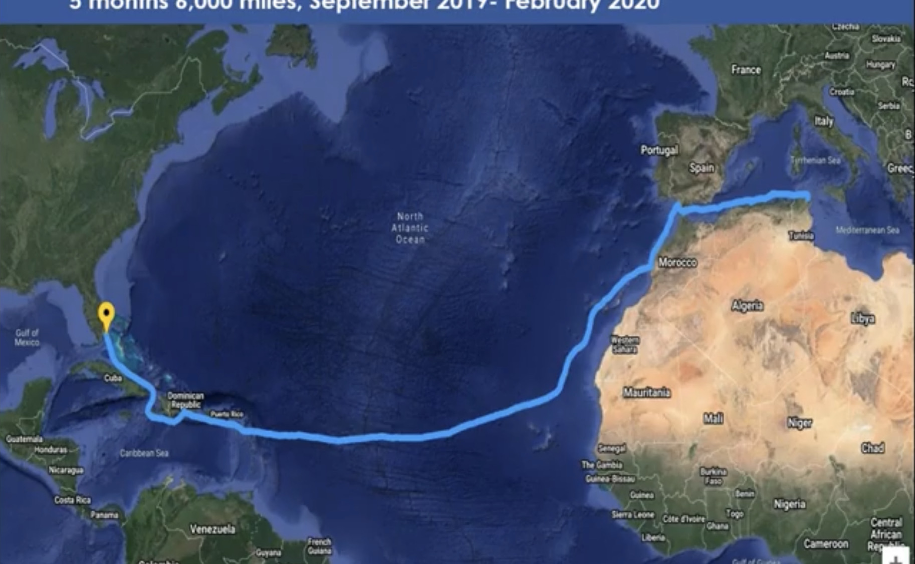
The Phoenicia Ship voyage of 2020 by Captain Philip Beale went from Tunisia through the Mediterranean then south to Florida, landing in Puerto Rico and then onto Miami. In Dec 2021, I sent the following email to Captain Beale:
Hi Philip:
I need your professional opinion as a navigator and ship Captain.
What are the advantages and disadvantages of a 600 BC ship to sail to Nauvoo, Illinois, USA.
We have two suggested paths and I would like a short answer of which pathway to Illinois would be most likely and why.
1. From Tunisia across the Atlantic similar to the path you took in 2020. Instead of landing on the East Coast of Florida the ship would continue around Miami and travel up the Mississippi River and stop in Illinois USA and Nauvoo?
2. Or from Tunisia going through Gibraltar and entering the St Lawrence Seaway following the Great Lakes through Lake Ontario Lake, Erie through Lake Michigan then taking the Mississippi River south to Nauvoo Illinois?
I am just looking for a basic decision based on the information you have now, with a most likely scenario.
Thanks for your suggestion.
Captain Beale answered me with an email that said the following.
Hi Rian,
It is fairly straight forward I think.. the southern route is by far the easiest because of the prevailing winds and currents.
If you look at the Gulf stream that was first identified by Benjamin Franklin… from the Med. to the Caribbean is a simple conveyer belt.(See Map Below)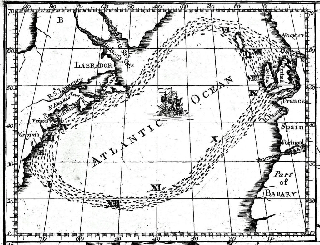
The winds and current are pretty much in synch most of the year and in the north north Atlantic the prevailing winds are West to East.. so very difficult for the Phoenicians to have gone the northern route.
Hope that helps. Philip
Watch videos of the replica 600 BC ship Phoenicia, with Mike and Betty LaFontaine owner of the actual replica ship and also from Captain Philip Beale the actual Captain of the voyages of the Phoenicia Ship on our subscription video site here: watch.bookofmormonevidence.org.

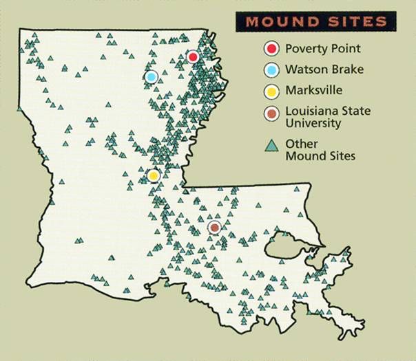
Mound Builders
“A number of pre-Columbian cultures are collectively termed “Mound Builders”. The term does not refer to a specific people or archaeological culture, but refers to the characteristic mound earthworks erected for an extended period of more than 5,000 years. The “Mound Builder” cultures span the period of roughly 3500 BCE (the construction of Watson Brake) to the 16th century CE, including the Archaic period, Woodland period (Calusa culture, Adena and Hopewell cultures), and Mississippian period. Geographically, the cultures were present in the region of the Great Lakes, the Ohio River Valley, and the Mississippi River valley and its tributary waters.
The first mound building was an early marker of political and social complexity among the cultures in the Eastern United States. Watson Brake in Louisiana, constructed about 3500 BCE during the Middle Archaic period, is currently the oldest known and dated mound complex in North America. [Maybe it isn’t, it could be Bilbo Mound in GA, see blog]. It is one of 11 mound complexes from this period found in the Lower Mississippi Valley. These cultures generally had developed hierarchical societies that had an elite. These commanded hundreds or even thousands of workers to dig up tons of earth with the hand tools available, move the soil long distances, and finally, workers to create the shape with layers of soils as directed by the builders.” Wikipedia
I want to thank my friend, Mike LaFontaine for finding and sending me the article below.
Remember it is very possible that the Jaredites or even the Adamites or Cainites once lived near Louisiana. After all, Adam was placed in Missouri and civilization could have easily spread up and down the Mississippi River. After the flood there could be many ancient remains left behind on the floors of the great deep.
MOUNDS IDENTIFIED AS OLDEST MAN-MADE STRUCTURES IN NORTH AMERICA

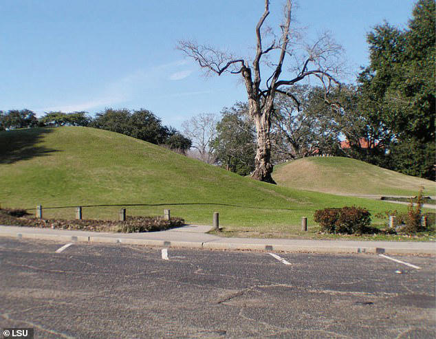
The two mounds stand 20 feet tall and are coordinated in an alignment toward one of the brightest stars in the night sky. They are among more than 800 man-made structures built by indigenous people across Louisiana.
Many of these mounds have been destroyed over the centuries, while the LSU campus mounds have remained preserved, listed on the National Register for Historic Places.
Researchers from the University collected sediment core samples, revealing layers of ash from burned reed and cane plants, as well as remains of burned osteons that indicates that the mounds were likely used for ceremonial purposes.
A radiocarbon analysis of the material suggests that the mounds were built over thousands of years, with construction of Mound B starting around 11,000 years ago.
Tree roots found in sediment layers shows that Mound B was abandoned around 8,200 years ago, a period when the northern hemisphere experienced a major climate event with temperatures suddenly dropping on average by about 35 degrees Fahrenheit, which lasted about 160 years.
Then, around 7,500 years ago, the indigenous people began to build a new mound, Mound A, just to the north of the first mound.
According to the new analyses, the indigenous people reconstructed the first mound during construction of Mound A, both being completed around 6,000 years ago.
“There’s nothing known that is man-made and this old still in existence today in North America, except the mounds,” said LSU Department of Geology & Geophysics Professor Emeritus Brooks Ellwood, who led this study, published in the American Journal of Science by Yale University.
The crests of both mounds are aligned along an azimuth that is about 8.5 degrees east of true north. According to LSU astronomer and study coauthor Geoffrey Clayton, about 6,000 years ago, the red giant star Arcturus would rise about 8.5 degrees east of north in the night sky, which means it would have aligned along the crests of both LSU Campus Mounds. Arcturus is one of the brightest stars that can be seen from Earth.
Louisiana State University
https://www.lsu.edu/mediacenter/news/2022/08/19gg_ellwood_lsucampusmounds.php
Following the Trail of Ancient Louisianans by Amelie A. Walker
|
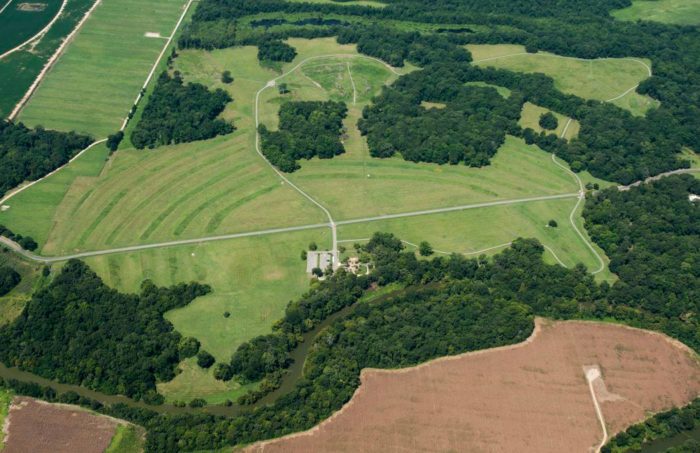
A mound at Marksville, one of the state-owned sites on the Louisiana Ancient Mounds Trail. (Mark J. Sindler/LA Office of Tourism) [LARGER IMAGE] |
![[image]](https://archive.archaeology.org/online/features/lamounds/thumbnails/lamounds1.gif)
“Known for Mardi Gras, jazz, and Cajun culture, Louisiana also has a wealth of Native American sites dating to as early as 4000 B.C. The most obvious remains of ancient peoples are the many mounds that can be seen throughout the state, in cotton and soybean fields, hidden in woods, or even under houses. In all, there are more than 700 mound complexes or individual mounds in Louisiana. Built over millennia, they include some of the oldest and best-preserved such structures in North America.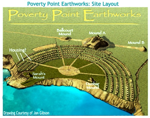
Mound building began around 6,000 years ago, at a time when people were becoming more sedentary, though not yet involved in agriculture, and continued until the period of European contact. The first mounds may have marked seasonal homes with abundant resources for nomadic hunter-gatherers, but mounds were used for different purposes at different times and places. Burials have been found in some mounds, while archaeologists have identified house patterns and found domestic objects on mounds that were apparently residential sites. Others likely served religious purposes. Whatever their use, these earthen structures are a reminder of cultures past, a heritage that should be protected and shared.
To celebrate Louisiana’s Native American mounds, a series of historical markers has now been installed, creating the Ancient Mounds Trail. Currently made up of 37 sites that can be viewed from public highways, the trail’s purpose is to educate the public about the state’s earliest people while also diversifying and expanding tourism. The mounds are a lesser-known aspect of Louisiana’s past, one that the state would like to better publicize and make accessible. More visitors would be especially welcome in mound-rich northeastern Louisiana, the region that currently receives the smallest number of tourists.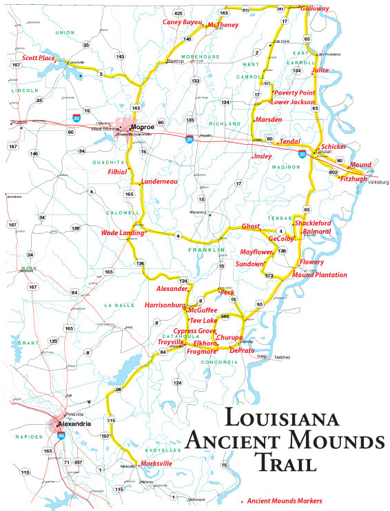
The Louisiana Ancient Mounds Trail is about a five-hour tour by car with stops at the museums at Poverty Point in West Carroll Parish and Marksville in Avoyelles Parish, which serve as the hubs to the trail. Individuals or groups with an interest in learning more about mound sites in Louisiana can start near Epps at the Poverty Point State Historic Site. There they will be introduced to mound building by watching a video, looking through the museum, and touring the site itself. They can then drive to see the other sites with a better understanding of the mounds and the people who constructed them.
The next state-owned site on the trail is Marsden, a group of mounds incorporated into Poverty Point Reservoir State Park and recently opened to the public. Though no full visitor’s center is planned at Marsden, there will eventually be more interpretative materials available there, and visitors can arrange for guided tours. Following the trail from northeast to central Louisiana, most of the rest of the historical markers are on privately owned mounds. These sites can be viewed from highways or to the extent each landowner allows (these markers will all have “No Trespassing” signs on their posts). The tour ends at Marksville, where there is another interpretive center.” Following the Trail of Ancient Louisianans by Amelie A. Walker
Remember it is very possible that the Jaredites or even the Adamites once lived near Louisiana. After all, Adam was placed in Missouri and civilization could have easily spread up and down the Mississippi River. After the flood there could be many ancient remains left behind on the floors of the great deep.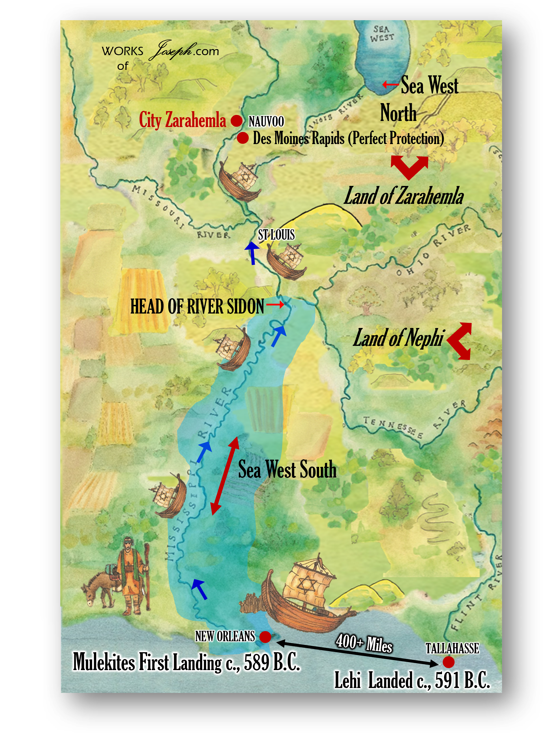
For additional information about these mounds in Louisiana see the links below.
-
MSN
https://www.msn.com › en-us › travel › article › why-did-ancient-louisianans-raise-vast-mystery-mounds › ar-AA1RdiSL
For now, the best-supported answers to why ancient Louisianans raised these vast mounds center on community, ceremony, and connection to both land and sky, with the understanding that future digs … -
The Historical Marker Database
https://www.hmdb.org › results.asp?Search=Series&SeriesID=371
Louisiana Ancient Mounds Trail Historical Markers The State of Louisiana has placed markers at 39 Indian mound sites in northeast Louisiana that form the mound trail. -
Louisiana Tourism
https://www.crt.state.la.us › Assets › OCD › archaeology › discoverarchaeology › virtual-books › PDFs › Ancient Mound Sites of LA.pdf?Ancient+Mound+Sites
Louisiana has some of the oldest, most spectacular, and best preserved Indian mounds in the world. Compared with other places, Louisiana has an unusually large number of mounds and earthworks, which span a long period of time. Although mounds are found across the state, they are concentrated in northeastern and central Louisiana. -
Caddo Nation
https://mycaddonation.com › historic-preservation
An article by Amelie Walker in Archaeology, a publication of the Archaeological Institute of America, discusses the mounds of Louisiana. Over 700 mounds are located all over the state, some of which are now joined by historical and interpretive markers to form the Ancient Mounds Trail. -
ArcGIS StoryMaps
https://storymaps.arcgis.com › stories › 0b1128fea4e649869a3804fa14aa4c7c
A Driving Trail Guide. Explore Louisiana, discover these unparalleled examples of ancient earthen architecture and join others in informing the world about the unique and awe-inspiring records of human creativity and engineering genius. Welcome to the Ancient Mounds of Northeast Louisiana Driving Trail! -
Louisiana Tourism
https://www.crt.state.la.us › dataprojects › archaeology › moundsguide › further-reading.html
1848 Ancient Monuments of the Mississippi Valley. Smithsonian Institution. (Reprint editions available). Swanton, John R. 1911 Indian Tribes of the Lower Mississippi Valley and Adjacent Coast of the Gulf of Mexico. Dover Publications, Inc. Walker, Winslow M. 1936 The Troyville Mounds, Catahoula Parish, Louisiana. Smithsonian Institution. -
Genealogy Trails
https://genealogytrails.com › lou › native_am.html
An ancient trail between their villages became the noted “contraband trail” along which traders and travelers journeyed between the French and Spanish provinces. -
WANE 15
https://www.wane.com › news › top-picks › these-ancient-native-american-trails-connected-in-northwest-louisiana
Jun 24, 2025It is an ancient Native American trail that winds through Missouri, Arkansas, and Louisiana before connecting with another series of trails that extended outward from Natchitoches, Louisiana.