
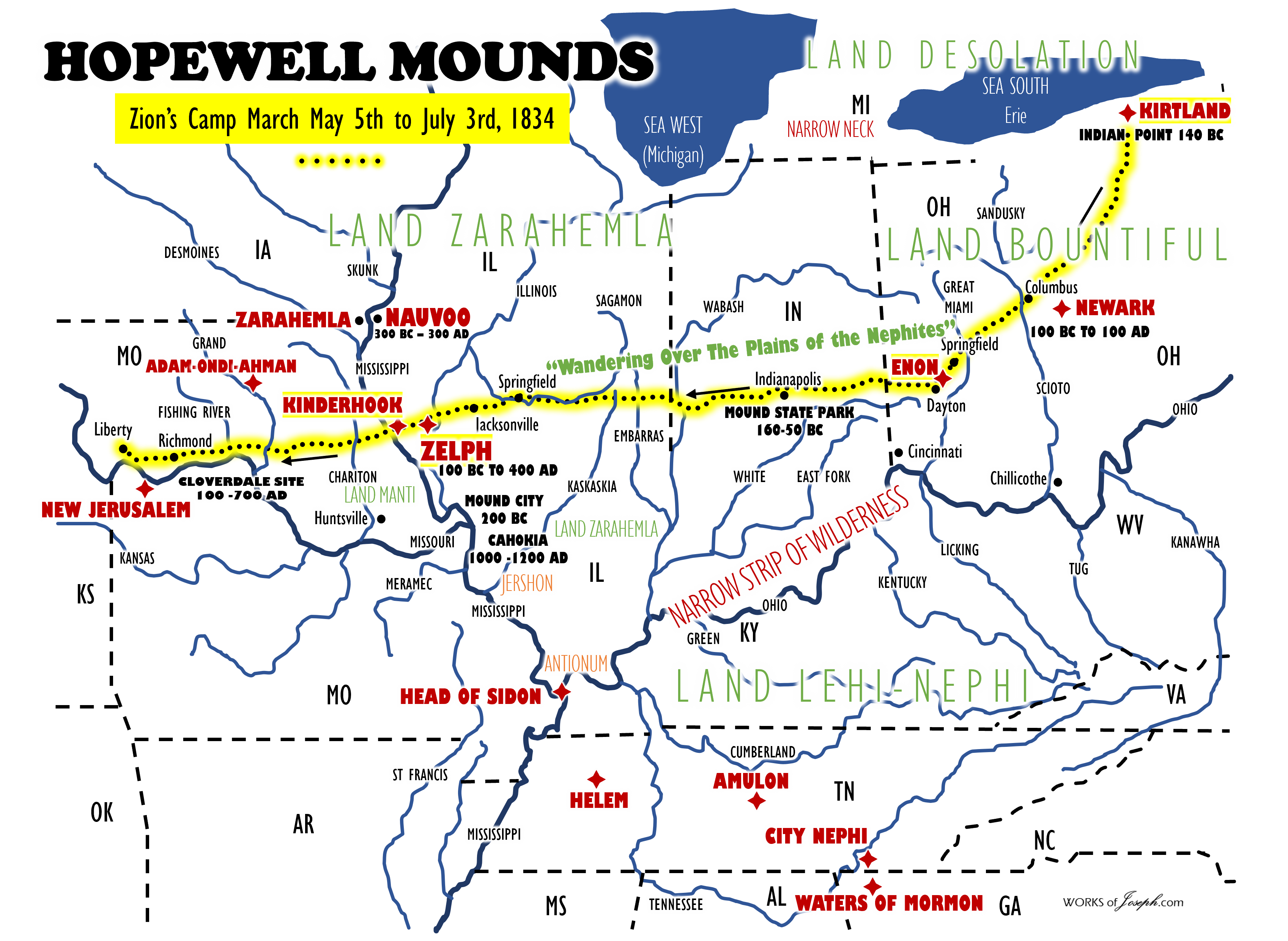
I believe Joseph Smith, who speaking Near Atlas, Illinois on the Mississippi River on Jun 2, 1834 said,
“The whole of our journey, in the midst of so large a company of social honest and sincere men, wandering over the plains of the Nephites, recounting occasionally the history of the Book of Mormon, roving over the mounds of that once beloved people of the Lord, picking up their skulls & their bones, as a proof of its divine authenticity… During our travels we visited several of the mounds which had been thrown up by the ancient inhabitants of this country-Nephites, Lamanites, etc.” Joseph Smith Papers Letter to Emma Smith, 4 June 1834 Page 56
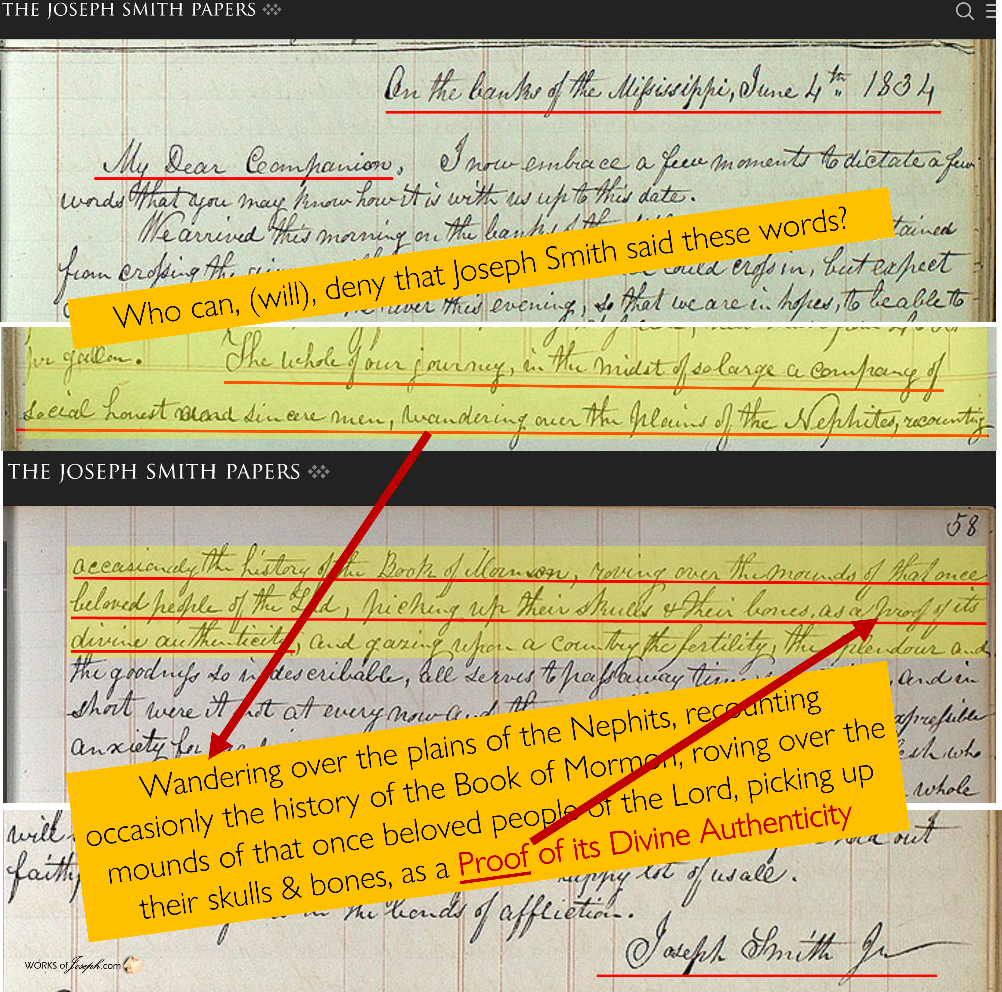
There ARE Hopewell Mounds that date to Book of Mormon Times in Illinois, Ohio, Missouri, and Iowa as Joseph Smith described while on Zion’s Camp march. This should not be denied if we believe the Prophet Joseph. He wrote this letter to his dear wife Emma saying, “picking up their [Nephite] skulls & their bones, as a proof of its [Book of Mormon’s] divine authenticity”
THIS IS WHY BOOK OF MORMON EVIDENCE, AND HEARTLAND RESEARCH GROUP, ARE IN MONTROSE IOWA. WE VERIFY TRUTH OF THE BOOK OF MORMON BY THE SPIRIT BUT CONFIRM MANY THINGS WITH SECONDARY WITNESSES THROUGH MANY ARTIFACTS, RESEARCH, MAGNETOMETRY, LiDAR, RESISTIVITY AND CORE DRILLING.
Joseph Smith and Family Buried among the Nephites
“The connections between Mormonism and the mounds of North America have yet to be fully explored. …The increasing awareness of the numerous Hopewell mounds in the Nauvoo area may give renewed attention to the connection between Mormons and the mounds. When workers dug a utility trench between the Red Brick Store and the Joseph Smith Homestead, the equipment churned up Hopewell bones and artifacts. This area is adjacent to the Smith Family Cemetery, leading to the possibility that Joseph Smith, his wife Emma, his brother Hyrum and his parents are buried in a Hopewell burial site.” The Mormons and the Mounds – Jonathan Neville Mormon History Association June 2017.
“Nauvoo appears to have been a destination for the living and the dead for centuries. According to Community of Christ Historic Sites Coordinator Lachlan Mackay, workmen digging a power wiring trench between the Smith Cemetery and Red Brick Store during the 1970s uncovered bones and artifacts, including a cardinal platform pipe from the Hopewell era (ca. 200 BC to 500 AD). This means that the Smith Family Cemetery was most likely built over an ancient Nephite graveyard.
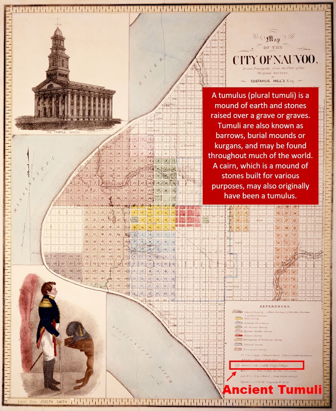
Lachlan Mackay referred to Gustavus Hills 1840 map above of Nauvoo which revealed ancient tumuli, or burial mounds, including some on Partridge Street below the temple hill. In 1844, Henry Brown quoted John C. Bennett’s 1842 description of Nauvoo: “The surface of the ground upon which Nauvoo is built, is very uneven. . . A number of tumuli, or ancient mounds, are found within the limits of the city, proving it to have been a place of some importance with the extinct inhabitants of this Continent” (History of Illinois, 1844, p. 490). Settlers, however, leveled the land for houses and gardens.” Laid to Rest in Nauvoo By Rosemary G. Palmer · July 17, 2014 Meridian Magazine
The Nauvoo Hopewell Mounds
“Beginning in 1998, Wilson [Curlee] and I had felt a gravitational pull to Nauvoo from our home in Helena, Montana, and began making yearly trips there, usually in conjunction to see family in other states. Without having a concrete plan, we decided in 2005 to buy a small second home in Nauvoo for retirement in a few years, and in the meantime, a place to spend our summers. And so it came to be that in 2009 when we retired and semi-relocated to Nauvoo that we were introduced to Heartland Model of the Book of Mormon geography. We were invited to a small gathering of people to hear a presentation about the possibility of the ancient city of Zarahemla having been located across the Mississippi from Nauvoo, near Montrose, Iowa, with the Mississippi River being the River Sidon. It was as if that night I began wearing a new pair of glasses. My view was broadened, clarified and in focus. I felt the hand of the Lord was in this, much like when I learned about the True Gospel taught by the Missionaries when I was 19 years old in Billings, Montana. At that time it was less than 12 hours later that I gained a testimony that the Gospel had been restored to the earth in these last days.
After hearing the presentation that summer night, I went home with my head spinning. As I was getting ready for bed, I had many thoughts about the years I had spent reading about Mesoamerica supposedly being where the Book of Mormon happened, although I never doubted that there was just one Hill Cumorah. I was sort of muttering to myself and to God at the same time, saying that I didn’t like this feeling of my “head being messed with”. Then very quickly and emphatically a voice came into my mind saying “You were always into archaeology and history, and wanted to go to Central America, but I put you in the MIDDLE of it here!!”. From the bathroom I called out to Wilson, “It’s True”! Once the Spirit answers, the discussion is over. It was the same voice that spoke when I knew the Restored Gospel was true. Was this the main reason we felt pulled to move to Nauvoo after all? Since that night it has been one roller-coaster ride after another. I have been writing significant things down as they happened, and then at the end of each fall I have typed them up to make a ruining log of the year’s events. If I had not actually lived it, I would think I was writing a novel made up out of my own imagination. That eventful summer ended with sharing this new information with like-minded friends and family; buying books and videos on the subject, and looking forward to the next summer when we would once again immerse ourselves in the spirit of Nauvoo, and see more of what the Midwest and the Nauvoo area would reveal regarding Book of Mormon evidence…” Jennice Curlee [The complete story blog at the end] 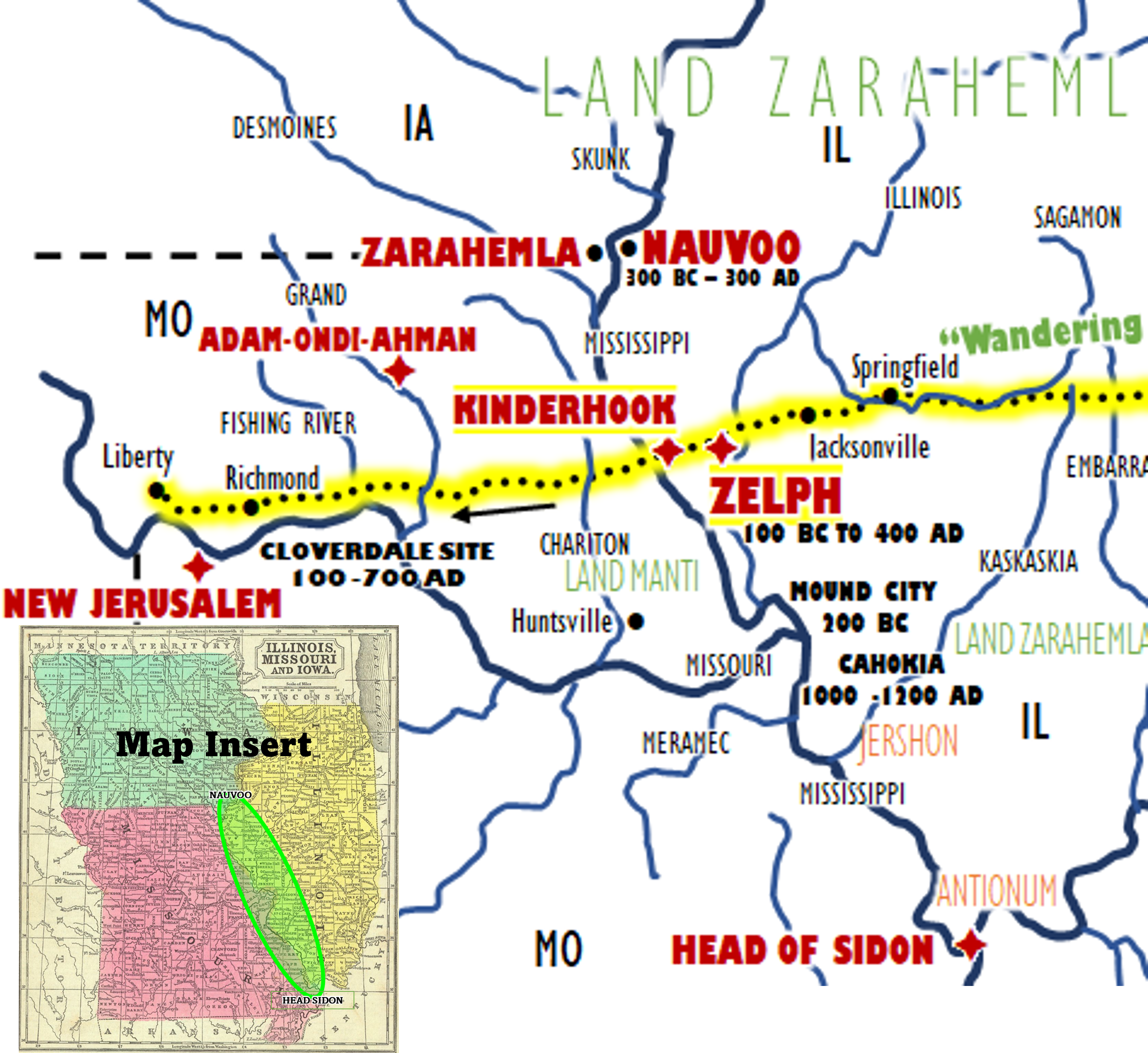
Heartland Research Update
The Phoenicia Voyages by Captain Philip Beale and Team are an ideal test of the veracity of the Book of Mormon account. It shows not only that the materials and technology of 600 B.C. allowed construction of ocean-going vessels for both Lehi’s group and the Mulekites, but that both groups could have crossed the Atlantic and landed in North America, coming from the east.
As you see in the maps below “The Phoenicia Expedition 2009-2010 and 2020, you will see the Phoenicia Ship Expedition has now demonstrated unequivocally that Lehi’s voyage could have left the Arabian Peninsula and sailed around Africa to Florida, rather than attempting to cross the earth’s largest ocean the Pacific at its widest point, as proposed by many Mesoamerican theorists. In 2009, the Phoenicia Expedition supports our vision, that Lehi’s Voyage to America was very possible. In the Phoenicia Voyage of 2020 seen below, is also evidence of a plausible voyage from Israel to North America, possibly traveling up the Mississippi River and having forced to stop just south of Nauvoo, Ill, by the presence of the Des Moines River Rapids. (See Omni 1:16)
Heartland Research would love to have guests, visitors, volunteers, speakers, and other experts that may want to help find Zarahemla and rebuild the Phoenicia. Phoenicia.rocks


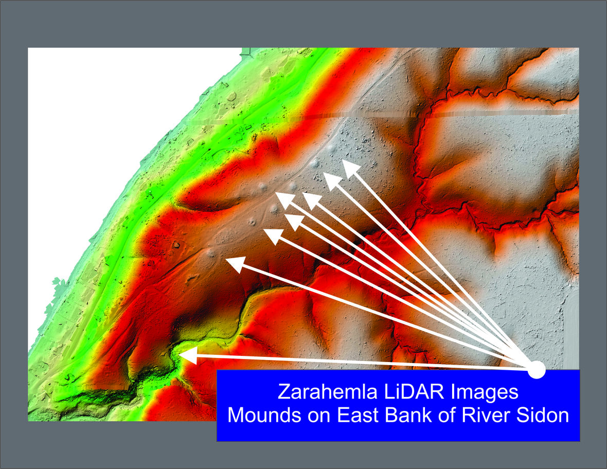
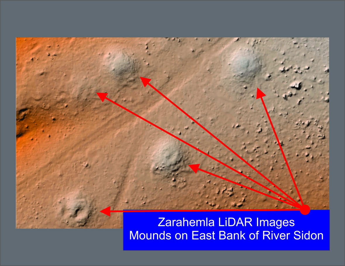
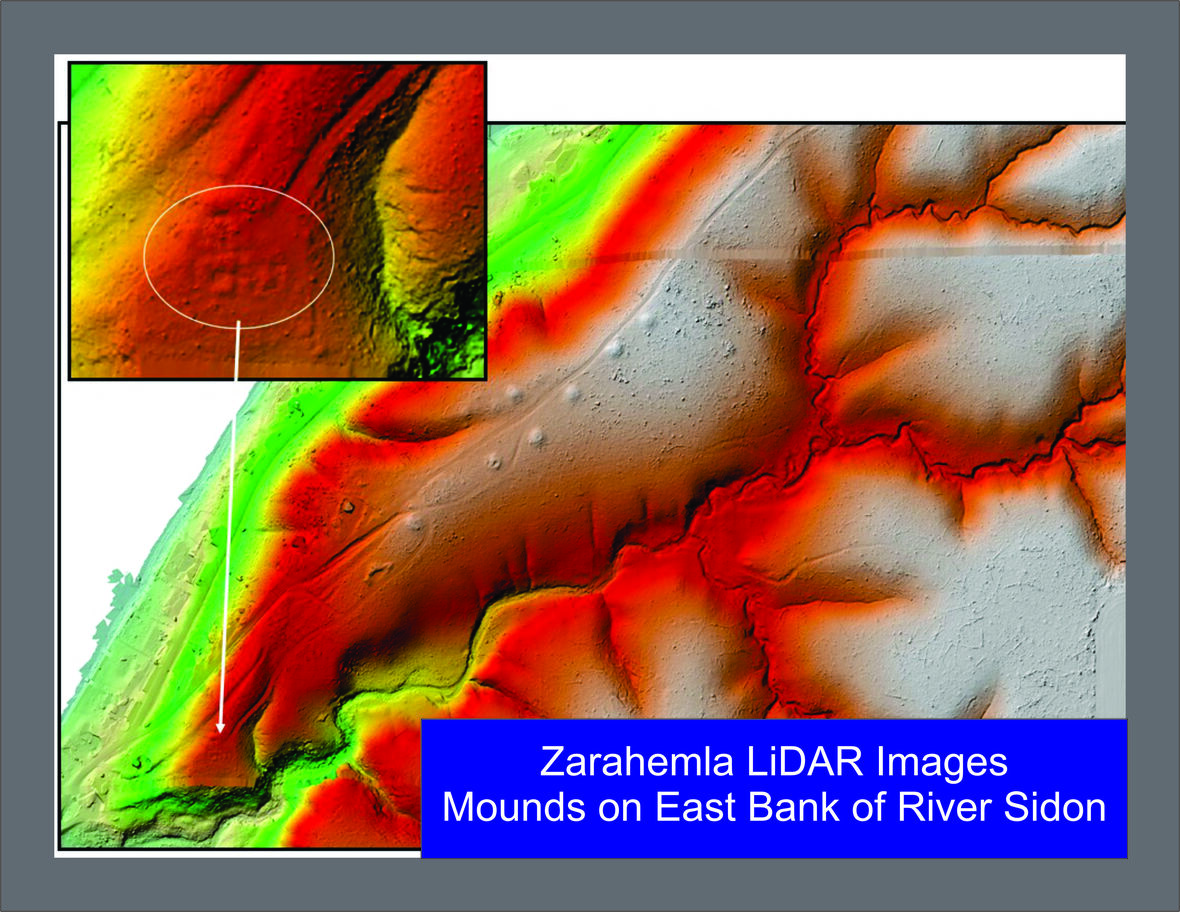
Nov. 6th 2021, a historic flyover near (article below) Nauvoo, Illinois of 34,000 acres that was completed, obtaining LiDAR Data to continue searching for more evidence about the Montrose, IA, or the Zarahemla area. In Nauvoo, Heartland Research has found ancient fire pits and artifacts, and they continue core hole drilling, magnetometry, LiDAR, archaeological digging, drone exploring, and many other new world scientific studies from experts all over the world. You will be fascinated with their work below.
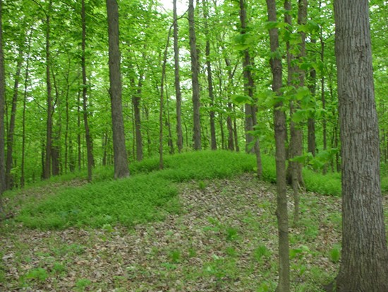
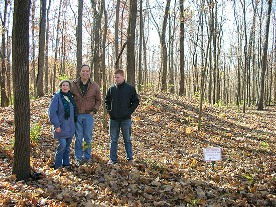
Here are some resent partial results of the Nov 6, 2021 LiDAR scanning completed. It shows you the obvious Hopewell Mounds found today on the Wilson and Jenny Curlee property near Nauvoo, Illinois. This is fantastic and more will come. Without a doubt previous Historians, Scientists and Archaeologists have verified ancient Hopewell mounds all over the Nauvoo, IL and Montrose, IA areas. Once again the Heartland Research Group continues to find details about the time period of the Nephites all over the Heartland of the United States.
|

