
I am tired of many Archaeologists and Historians in The Church of Jesus Christ of Latter-day Saints constantly saying, “There is no evidence on Hill Cumorah of swords, or bones or arrowheads found on the hill. We have to have proof”, they say. Well, I will share with you here an abundance of evidence on and near the Hill Cumorah that will show there was a huge battle near Hill Cumorah. It is as well known in the Church as it is with non member archaeologists. I suggest these naysayers listen to Prophets who have testified that the last battles were indeed fought at the Hill Cumorah in New York.
I know that the things I have presented to you today are true—
President Marion G. Romney of the First Presidency stated: “I will give you a lesson today that the Lord has taken great pains to bring to us… In the western part of the state of New York near Palmyra is a prominent hill known as the “hill Cumorah” (Mormon. 6:6). [There] perished at the foot of Cumorah the remnant of the once mighty Jaredite nation, of whom the Lord had said, ‘There shall be none greater… upon all the face of the earth’ (Ether 1:43, p. 461). “As I contemplated this tragic scene from the crest of Cumorah and viewed the beautiful land of the Restoration as it appears today, I cried in my soul, How could it have happened?… This second civilization to which I refer, the Nephites, flourished in America between 600 B.C. and A.D. 400. Their civilization came to an end for the same reason, at the same place, and in the same manner as did the Jaredites…I bear you my personal witness that I know that the things I have presented to you today are true—both those pertaining to past events and those pertaining to events yet to come.” (145th Semiannual Conference, Saturday Morning Session, October 4, 1975; emphasis added.)
As you view the map below, you will see archaeological evidence of many forts, artifacts, bones, skeleton’s and weapons from the ancient NY area according to the NY Archaeological Society.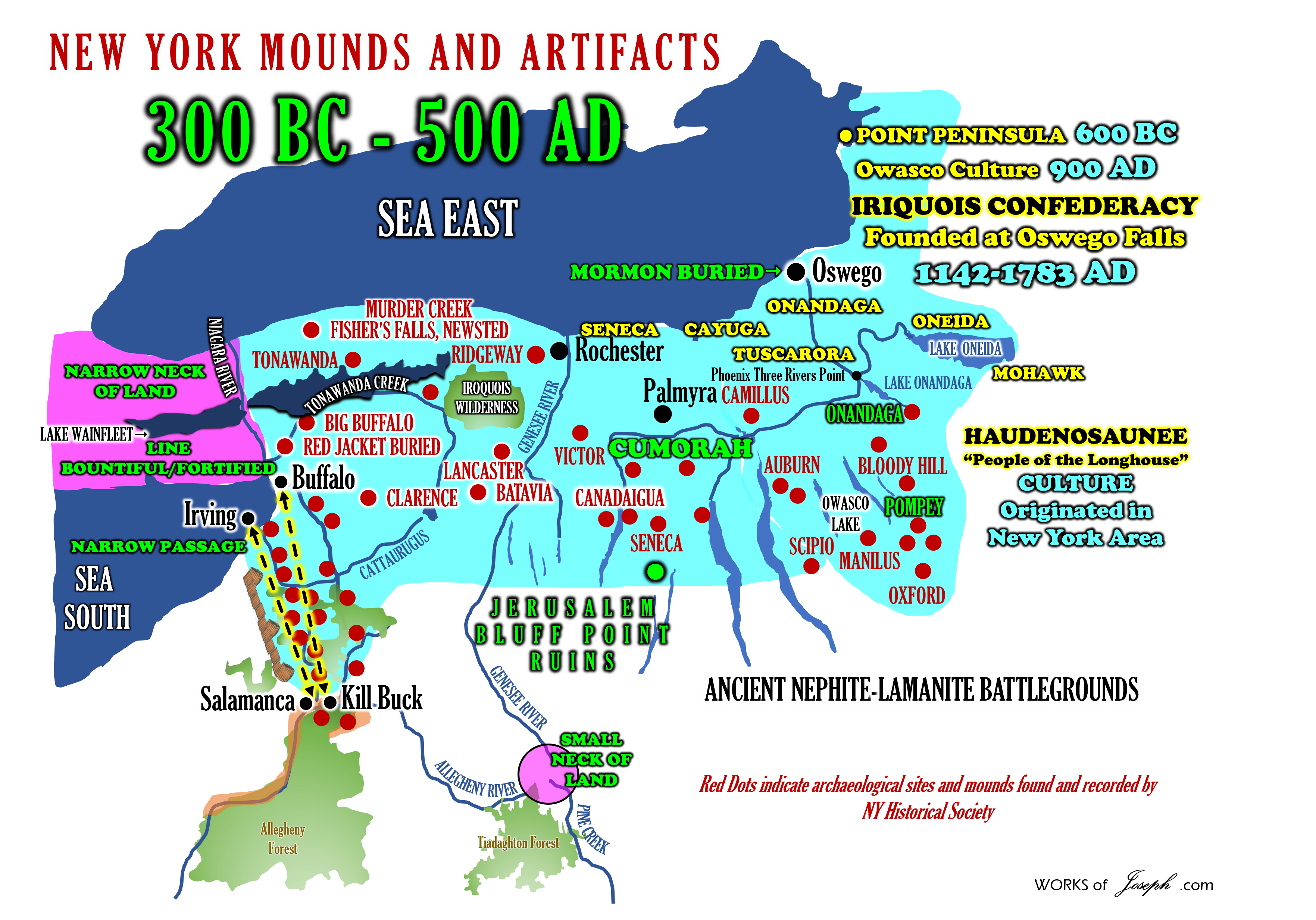
Bone Heaps on the Genesee River
“My flats were cleared before I saw them; and it was the opinion of the oldest Indians that were at Genishau, at the time that I first went there, that all the flats on the Genesee river were improved before any of the Indian tribes ever saw them. I well remember that soon after I went to Little Beard’s Town, the banks of Fall-Brook were washed off, which left a large number of human bones uncovered. The Indians then said that those were not the bones of Indians, because they had never heard of any of their dead being buried there; but that they were the bones of a race of men who a great many moons before, cleared that land and lived on the flats” (Nephites, Jaredites). A Narrative of the Life of Mrs. Mary Jemison Author: James E. Seaver 1823 Chapter VII page 61
“In the position of the skeletons, there was none of the signs of ordinary Indian burial; but evidences that the bodies were thrown in promiscuously, and at the same time. The conjecture might well be indulged that it had been the theatre of a sanguinary battle, terminating in favor of the assailants, and a general massacre, A thigh bone of unusual length, was preserved for a considerable period by a physician of Lockport, and excited much curiosity.” (Turner, p. 27) [Sanguinary means: Eager for bloody violence; bloodthirsty].
 One Half Mile from Mormon Hill
“In 1922 “on the Rose farm, one half mile from Mormon Hill” a number of large skeletons, stone implements, copper ornaments, a copper axe of unusual type, and other articles were found. At this historic spot were found “many of unusual physique, tall, long-limbed, finely formed skulls, teeth finely shaped.” (Fred Haughton, Seneca Nation, p. 48)
Previous Superior Native Cultures
“The battles are described as often having culminated in the destruction of previous, superior Native cultures which had taken final refuge in forts at the tops of hills, including the general region of the hill known to Mormons as Cumorah. In the town of Camillus, in the same county of Onondaga . . . there are two ancient forts . . . One is on a very high hill, and its area covers about three acres. . . . The ditch was deep and the eastern wall ten feet high. In the centre was a large lime stone of an irregular shape.” A Memoir on the Antiquities of the Western Parts of the State of New-York, Addressed to the Honourable Samuel L. Mitchill, a Vice-President of the Literary and Philosophical Society of New York . . . by Dewitt Clinton . . . Read Before the Society November 13th, 1817 De Witt Clinton (1769-1828)
War with a Light Skinned People
“Chief of Seminole Tribe: “We had a war long ago with a light skinned people around the Great Lakes. We conquered them but we had so much respect for their warrior chief that we buried him at the mouth of the Oswego River that is in New York State. We don’t discuss this very much because it is an embarrassment to us. President Rawson then asked why this is an embarrassment, and the Chief replied, “ Our history is written on metal plates and buried in a hill in New York, but we don’t know which hill!” (Talk given to missionaries in training at the MTC, Provo, Utah 1979, by President Murray J. Rawson).
Archaeological Evidence for the Ancient Hopewell and Adena Culture
The purpose of the information below is to share with you significant archaeological evidence for the ancient Hopewell and Adena Culture nearby the Hill Cumorah. There is evidence of fortifications, pottery, copper, weapons, palisades, forts, mass burials, mounds, tools and other artifacts all around this area. I believe the Hopewell culture matches up with the Nephite culture extraordinarily well. (See Map Above) The Hopewell originated in 600 BC at the panhandle of Florida from Crystal River to Pensacola, Florida. History documents this. The Hopewell then traveled north into Georgia and Tennessee. There is evidence of a huge society of the Hopewell from Missouri to Illinois to Indiana and then to Ohio which was the dominant historical area of this people. History shows the end of the Hopewell civilization around the year 400 AD. Historians say the Hopewell just disappeared and historians have no idea what happened. I feel I have a good idea. The final battle at Cumorah was 385 AD. This is some of the best evidence of a possible link to the Hopewell and the Nephites.
My friend who is a very loving Christian Preacher and an Avocational Archaeologist, who has lived in Ohio his entire life, jokes with me and says, “I know the people of Ohio as Hebrews and you know them as Nephites. We have found the same people.” Doesn’t it really make sense that there has to be traces of Hebrew where Lehi and Nephi lived? Search for yourself. Many signs show Hebrew influence in North America and especially in Ohio. It’s sad that many professionals say all the artifacts are a hoax. They have to say that for over 20 various items that have been discovered. See my blog here and here:
After reading the material from only these two sources, you will come away with amazing enthusiasm that ancient people lived in North America during the same time period as the Nephites and the Jaredites. Those that lived from about 1,500 BC to 200 BC were historically called the Adena culture. See my blog here.
To access my two main sources of this blog, visit the links below:
THE ARCHEOLOGICAL HISTORY OF NEW YORK BY ARTHUR C. PARKER, ARCHEOLOGIST
THE ARCHAEOLOGY OF NEW YORK BY WILLIAM RITCHIE
RESOURCE #1
THE ARCHEOLOGICAL HISTORY OF NEW YORK BY ARTHUR C. PARKER, ARCHEOLOGIST

New York State Museum JOHN M. CLARKE, Director
List of Sites Page 654 Ontario County, NY (Time Period 100 BC to 1700 AD)
1- Village and palisaded hilltop stronghold on Boughton hill 1 1/ 4 miles south of the village of Victor. This famous site is on the farms of M. E. McMahon, W. B. Moore and W. J. Greene. It occupies the top of Boughton hill and lies along the 800 feet contour line, which is 250 feet above the village of Victor. The hill points northward and is bounded on the eastern, western and northern sides by precipitous slopes that drop to the valleys of two brooks, both of which flow into the Mud creek. The westmost brook is known as White brook and takes its beginning in a spring on the side of a hill. This site is that of the Gandagora which was destroyed by DeNonville in 1687. It was visited by Greenhalgh in 1677 who said it resembled Onondaga. Before its destruction the Jesuits had established in this village, a mission which they called St Jacques, so that there are fairly adequate contemporaneous accounts of the village and its occupants. The site was excavated by Frederick Houghton for the Buffalo Society of Natural Sciences. His excavations are described in volume 10, number 2, of the bulletin of the society.
 2- Fort and stronghold site known as Fort hill 11/2 miles west of Boughton hill in an air line. This corresponds with DeNonville’s account of the ” picket fort at the top of a little mountain, scarped on all sides.” Some fifty years ago traces of the earthwork or palisaded bases were to be seen, but this wall has now been destroyed by cultivation.
3 Burial place I mile from Boughton hill on the John Bunce farm ‘his is directly south and on the east side of the Bloomfield road near the county line. This site was excavated by Frederick Houghton who found more than fifty pits containing human remains and many objects of European manufacture intermixed with articles of native lake.
4 Village site on the farms of Jesse and George Marsh, and a burial site on Ira DeLong and David Thompson’s farms. This site is near the northeast corner of East Bloomfield and on lot 13. It is about one-fourth of a mile east of Mud creek and on the eastern slope of brook running into it. Without doubt it is the site of the Jesuit mission of St Michel, which was occupied mostly by the captive Neuter and Huron converts after the destruction of their nations, in historical accounts the site is known as Gandougarae.
5 Burial place near this village on the farm of Ira DeLong, excavated by Frederick Houghton.
6 Burial place also connected with the Gandougarae site on le farm of George Marsh, which has been excavated by Heman Coates, Fred Hamlin, William L. Bryant and Frederick Houghton. Mr. Houghton has described the site on page 42 of his monograph in the ” Seneca nation, from 1655 to 1687.”
7 Village and burial site on lot 35, East Bloomfield, on the Henry Fox farm. It is on the bank of Mud creek and most of the graves are found in the heavy red clay.
8 Village site on the Appleton farm on the eastern bank of Fish creek, at the forks of the road 2 miles northeast of Holcomb station. The village tract covers a considerable area of land and European objects have been found.
9 Village and burial site on the Beale farm, lot 7, East Bloomfield. This is on the south side of Cherry street one-half of a mile west of the road from Victor to Holcomb and just south of the Victor Township line. It is 1 1/ 2 miles south of Boughton hill and occupies an irregular knoll surrounded on three sides by small streams. Mr Houghton estimates the area as 15 acres. The usual material found on sites of the early historic period are present. Burials were located by Houghton on a knoll on the western edge of the village. They were- deep in the clay and sand and sometimes as many as six bodies were found in the burial pits. Houghton records thirty-four graves and describes the site on page 239 of the ” Seneca Bulletin.”
10 Extensive village site on the Augusta Warren farm, lot 75, West Bloomfield, near the railroad station. The site occupies the rolling land along the eastern site of Honeoye creek. Between the site which lies on the hill some 50 feet above the creek and the stream itself are wide flats some 200 to 300 feet from the base of the hill. The site seems to have been occupied for an extended period and has two cemeteries. More than twenty entire pottery vessels were found in the burials, together with many articles of shell, bone, stone and wood.
11 Village and burial site at Factory Hollow on lot 64, West Bloomfield. The site occupies the abrupt terrace above the Honeoye outlet and above the eastern slope. The hill is very steep ; a village i burial site lay upon its top 100 feet above the valley. The burials were found along the western edge of the hill a little distance from the main village site. Here more than one hundred graves have been opened but very few objects of European occupation have been found except brass kettles. The village site proper occupied the wider portion of the hill at the southern end and all along the edge of the numerous refuse deposits that contained many bone implements, notched and serrated potsherds, and other discarded and broken material. Locally the place is known as the ” Shattock site ” and the hill as ” Fort hill.” The period is the beginning of European contact.
12 On his map of the Seneca country, Gen. J. S. Clark placed an Indian village almost in the center of the town of East Bloomfield. Mr Hildburgh reported a cemetery there.
13 Village site reported by Fred H. Hamlin on lot 16, East Bloomfield, on the Nead farm.
14 Village site on the Andrews farm at the north angle of the road northwest of Bristol.
15 Just southeast of this in the upper portion of the valley of Mud creek is a river site on the Sears farm.
16 Site on the Jackson farm in the northeast corner of Bristol township, just south of the Richmond Mills road and southwest of Bristol hill.
17 Village and hilltop stronghold on the George Reed farm near the western boundary of Richmond township and on the southeast side of the Hemlock lake outlet. This site is on a sand hill that lies between two small streams running into the outlet; on the north side is a high slate bank running down into the brook. A pathway down the upper slope of this bank leads to a fine spring which probably supplied water for the village. The opposite ravine is less deep but separates the tract of land from the gradual sloping hillside beyond. Throughout the site, especially the lower portion facing the valley, many pits have been found from which excavators have taken numerous objects of flint and bone. The hillside refuse deposit are especially rich, but no object of European origin has yet been discovered. The site seems in every way a precolonial Seneca village; the type of the potsherds discovered are similar to those found on the sites of the colonial period throughout the region. The State Museum has a collection of some one thousand specimens taken from the site by Alva H. Reed. For detailed description
18 Burial site on lot 25 on the John C. Briggs farm west of the site of Honeoye, in the town of Richmond. About twenty skeletons have been found in a gravel pit. A small village site is just to the northeast.
19 Burial site on lot 23 in Richmond, on the Blackner farm, reported by Albert Van Buren.
20 Honeoye, at the foot of Honeoye lake one-half of a mile east of the outlet and south of Mill creek, was burned in 1779 (Sullivan, p. 130). There were recent articles on Phelp’s flat near the old Indian castle at the foot of the lake (Turner, P. & G., p. 199, 203). Clark placed the village on his map west of the outlet, but there are two older sites there, one village and one cemetery.
21 A small cemetery was 3 miles south of Canandaigua, west of the lake.
22 Randall reported a small cemetery 3 miles west of Canandaigua on a flattened ridge.
23 A mile east of Canandaigua was an oval work on a hillside overlooking the lake, with one gateway and half the wall remaining. The turnpike road from Canandaigua to Geneva passed through it. An early cemetery also (Squier, p. 55, pi. 6, no. 2). This appears in figure 66. Schoolcraft placed it on Fort Hill a mile north of Canandaigua and 1000 feet around (Schoolcraft, Report, p. 109).
24 Mr Hildburgh located a village and cemetery on Arsenal hill one-half of a mile west of Canandaigua, lot 32.
25 Village or camp at the north end of the lake near the outlet and camps along that stream.
26 There was an early site on the east side of the lake a little south of this.
27 On the west shore, just south of Canandaigua, was another early site with caches. A small burial site (21) is nearby (Clark).
28 Graves have been found near the courthouse and a cemetery just west of the village.
29 Ossuary containing eighteen skeletons was found in the park at the outlet. Mrs F. F. Thompson has erected a marker to these ” unknown graves.”
30 Relics have been reported from Squaw island, at the foot of Canandaigua lake.
31 A grave of burned clay was opened on the east side of Canandaigua lake in July 1893. It was 4 miles south of Canandaigua and one-half of a mile east of Gage’s landing. ” Many early relics were found in the vicinity.”
32 Village site on Darwin McClure’s farm, lot 20, Hopewell, 3 miles southeast of Canandaigua, one-half of a mile north of the turnpike. A recent cemetery is not far away, and modern relics have been found. The site is probably that of one of the Onaghee villages.
33 Burial site on the Albert Rose farm I mile north of Machester. Several graves have been opened and relics believed by Mr Follett to be of ” mound-builder origin ” have been found. Mr Follett describes a native copper axe from this site and says it is of an unusual type.
34 A small village was west of Manchester Center, on the south bank of Canandaigua outlet, nearly 21/2 miles northwest of the village west of Clifton. Earthenware and articles of stone occur. It was probably a fishing camp.
35 A large fortified town was in the town of Phelps, on the south side of the bluff facing Canandaigua outlet. A wall has been described there. No recent articles have been found; all are of stone or clay. The .site is northwest of the village of Phelps.
36 Five miles northwest of Geneva, in Phelps, was a stockade on Fort hill. This was not far from a hill on which was an earthwork. It was a long parallelogram through which the road ran, on one side of which the post holes remained. There were caches and early relics (Squier, p. 87, 88, pi. 13, no. 2).
37 Large village site just northeast of Naples, and lying between Naples and Old creek. The occupation is Algonkian. No bone articles are found. D. D. Luther has collected a large number of implements from this and adjacent sites.
38 Burial site in Naples village. Iroquoian. Pipes have been found.
39 Small village site with burials on the west side of Honeoye lake on the California ranch. Four skeletons were exhumed here during highway excavations.
40 Earthwork 3 1/2 miles northwest of Geneva, east of the Castle road. It was 800 feet long and an early site on high ground (Squier, p. 55, pi. 7, no. 1). There are graves in the southern part.
41 Among the pine barrens on Mr Swift’s farm 3 miles north of Geneva is a small site, with early relics, reported by Dr W. G. Hinsdale.,
42 In Geneva, on the old DeZeng place, west of Main street, were many early relics and also camps near the south end of Main street on the south side of Glass Factory bay.
43 Kashong, on Kashong creek, 7 miles south of Geneva, was burned in 1779, but the recent site is hardly well defined. A recent cemetery was opened near the lake in 1889.
44 Village and burial site on Wilson creek, lot 32, Seneca.
45 A small cemetery was opened near Melvin hill in 1896. The heads of skeletons were to the west.
46 There is a scattered site with early relics on the farm of John Laws on the county line north of the Waterloo road.
47 George S. Conover reported a group of recent sites on Burrell creek, which are here placed under one number. The creek is very crooked and the lots are not in regular order.
48 There was an orchard and a small cemetery on lot 36, Seneca, east of the creek on the Rupert farm. Fireplaces have been found.
49 A mile east of this and south of the creek was a recent village and cemetery on the old Wheadon farm, on lot 12.
50 A recent cemetery without relics and with longitudinal burial was on the Rippey farm, lot 9, south of the creek.
51 A trail from the southeast came to the center of the old Brother farm on which there was a village. It followed the highway north- westerly.
52 Site west of Flint on Flint creek. Stone age material. Reported by H. C. Follett.
53 Canaenda was removed to lot 32 on Burrell creek where there, was a large cemetery mostly on N. A. Read’s farm about 25 rods southwest of the creek. On that farm and east of the creek was one of the principal sites of the town.
54 On lot 31, west of the creek, was another recent cemetery.
55 Lodge sites and a cemetery were on the Hazlet farm, lot west of Burrell creek.
56 Burial mound, recent, at Clifton Springs ; explored by J. Sanborn.
57 Early village site just south of Clifton Springs, nearly a mil south of the Canandaigua outlet. It occupied a little over 2 acres. Explorations by J. W. Sanborn in 1889 revealed fireplaces very numerous and close together. It seems to have been long inhabited and was of early date. There are fragments of decorated pottery fine celts and arrowheads. Articles of bone have been found, none of shell. Reported by Irving W. Coates.
58 Early village, reported by Mr Coates, is 1 l / 2 miles west of one at Clifton Springs. The relics are similar to those found the site above mentioned excepting that no bone articles have been found. It was a small village, but the few fireplaces are large and deep. The site is a mile south of the Canandaigua outlet one-fourth of a mile west of Fall brook.
59 Skeletons have been exhumed and relics found at Littleville, a hamlet on the creek south of Shortsville. Some of the latter indicate early visitors, and several trails converged at the ford there.
60 Three-fourths of a mile south of Chapinville, near the creek, was a workshop. Flint chips, unfinished weapons and fine stone articles were once frequent there. Some other reputed Indian sites which he had not personally examined, Mr Coates did not describe.
61 Small village site reported by J. H. V. Clarke.
62 Village of Kanadesaga, situated just west of the city of Geneva. This was one of the important Seneca towns burned by General Sullivan in the punitive raid of 1779. Squier, who visited the site in 1840, said that the palisade traces were distinct, due to the fact that the Indians in ceding the lands stipulated that this, their famous town site, should not be used for cultivated ground. Their plea was, ” Here sleep our fathers, and they can not rest well if they hear the plow of the white man above them.” When Sullivan destroyed the village it consisted of fifty houses with adjacent fields of corn and large orchards. The raiders destroyed the corn, hay and other stored food and cut down the orchards. In robbing the houses they found many trinkets, pelts and other things of value. Near the village was a mound in which the body of a giant Seneca was reputed by tradition to be buried. In the center of the village was a stockade built by Sir William Johnson. Morgan and Squier have written in an interesting manner concerning Ga-nunda-sa-ga and the records of Sullivan’s expedition give a contemporary description of it. The Rev. Samuel Kirkland spent some time here and had an interesting adventure. It was here that the great
Gaiyengwahtoh or Disappearing Smoke lived.
63 Village site and stockade site 2 miles southwest of Geneva.
64 Small village site a mile east of Littleville, and southwest of Manchester, on the southern portion of lot 25. Here have been found many beautiful specimens of chalcedony points. Mr Follett says that here in a lump of hard clay found 3 feet below the surface were found five ancient looking and crude chert points.
65 Camp site, evidently an extensive and permanent one, is situated just one-fourth of a mile north of
64. There is a fine spring here known as ” The Indian spring.” Relics of many sorts are found in the adjacent fields, but mostly on the Follett farm. There are places where the arrow and spear points are crude and primitive; other places where there is plain evidence of European contact, as Mr Follett points out in the instance of the finding of a copper spoon with a bullet hole through the bowl.
66 Village and camp sites at the head of Honeoye lake on the farm of Delevan Alger. Bolo stones or grooved weights have been found here, according to Mr Follett, who also reports several perforated disks of sandstone. Mr Dewey has two specimens of these from this site.
67 Village and camp sites on the east side of Honeoye lake, where hammer stones and notched points have been found.
This is the end of information about Ontario County, in THE ARCHEOLOGICAL HISTORY OF NEW YORK BY ARTHUR C. PARKER. There are hundreds of other pages of additional counties in New York as well. It’s amazing information.
RESOURCE #2
THE ARCHAEOLOGY OF NEW YORK STATE BY WILLIAM A. RICHIE

THE MOUND-BUILDERS BY HENRY CLYDE SHETRONE Director and Archeologist, The Ohio State Archaeological and Historical Society. COPYRIGHT; 1930, BY D. APPLETON AND COMPANY https://dn790003.ca.archive.org/0/items/moundbuildersrec00shet/moundbuildersrec00shet.pdf
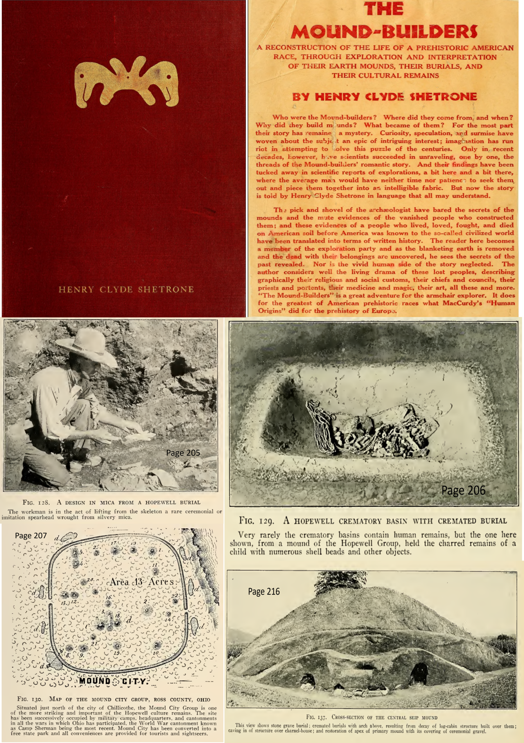
The mound-builders : a reconstruction of the life of a prehistoric American race, through exploration and interpretation of their earth mounds, their burials, and their cultural remains
by Shetrone, H. C
Ancient Burial Sites of New York
The following article is from JosephKnew Vidoes here: https://www.youtube.com/watch?v=f261yqM2Jhk
E-G-Squire Antiquities of New York
In earlier articles we have discussed the skillful and precise construction of great cities, large temple mounds and military defenses. The information in these articles has come from a variety of sources, including personal visits to the sites. Some of the best information on the ancient civilizations of North America has been provided by Ephraim George Squier (1821 – 1888). Along with his research and publishing partner Edwin Hamilton Davis (1811 – 1888), he unknowingly provided us with great insight into the lives, religions, cities and social networks of the people of the Book of Mormon.
In his book, Antiquities of the State of New York, Squier chronicles something much different than is found in his previous publications, Ancient Monuments of the Mississippi Valley and Aboriginal Monuments of the State of New York. Instead of descriptions of beautifully aligned cities, or carefully laid out military forts, he reports of works “constructed in haste for temporary purposes”. He details evidence of “indiscriminate massacres” and “bone-pits”.
Connections to the Book of Mormon
Joseph Knew Mormon Media Network
Final Battle near Buffalo NY. In the Book of Mormon, in the 6th chapter of Mormon, the Nephites gather to the land Cumorah for the final battles with the Lamanites. If, as we have proposed in a previous article, the land Cumorah was in upstate New York near the Hill Cumorah, Rochester, and Buffalo, then the following passage from Squier’s chapter Ancient Work near Buffalo takes on significant meaning.
“Tradition fixes upon this spot as the scene of the final and most bloody conflict between the Iroquois and the ‘Gah-kwas’ or Erie — a tradition which has been supposed to derive some sanction from the number of fragments of decayed human bones which are scattered over the area.” (Antiquities of the State of New York, E. G. Squire, M. A., 1851, page 74)
Tens of Thousands Killed
“And Lamah had fallen with his ten thousand; and Gilgal had fallen with his ten thousand; and Limhah had fallen with his ten thousand; and Jeneum had fallen with his ten thousand; and Cumenihah, and Moronihah, and Antionum, and Shiblom, and Shem, and Josh, had fallen with their ten thousand each.” (Mormon 6:14)
The number of people slaughtered at Cumorah seems incomprehensible. Many non-believers cite these passages as evidence of Joseph Smith’s great imagination. Surely there would be evidence today of such large numbers of dead people. While excavating along the banks of the Erie Canal the following was recorded:
“In excavating the canal through the bank bordering the flats, perhaps thirty rods south of the fort, another burial-place was disclosed, evidently more ancient, for the bones crumbled to pieces almost immediately upon exposure to the air, and the deposits were far more numerous than in that near the river. The number of skeletons are represented to have been countless, and the dead had been buried in a sitting posture.” (Antiquities of the State of New York, E. G. Squier, M. A., 1851, page 144)
“One of these pits discovered some years ago, in the town of Cambria, Niagara County, was estimated to contain the bones of several thousand individuals.” (Ibid, page 99)
Squier uncovered evidence of savage warfare, which left “bone-heaps” and “bone-pits” throughout the Finger Lakes region of New York (Cumorahland).
“Besides the various earth-works, there are a number of other interesting objects of antiquarian interest in this county. Among them may be mentioned the ‘bone-pits’ or deposits of human bones. One is found near the village of Brownsville, on Black River. It is described as a pit, ten or twelve feet square, by perhaps four feet deep, in which are promiscuously heaped together a large number of human skeletons.” (Ibid, page 29 – italics in the original)
“Near the town of Fulton, on the west side of Oswego River, is an eminence called ‘Bone Hill’ in which have been found great numbers of human bones promiscuously heaped together. They are much decayed. Intermixed with them were discovered a number of flint arrow-heads.” (Ibid, page 31 – italics in the original)
In Genesee County the ruins of a large enclosure were discovered.
“It was called the ‘Bone Fort’ from the circumstance that the early settlers found within it a mound, six feet in height by thirty at the base, which was entirely made up of human bones slightly covered with earth. A few fragments of these bones, scattered over the surface, alone mark the site of the aboriginal sepulcher. The popular opinion concerning this accumulation is, that it contained the bones of the slain, thus heaped together after some severe battle.”
“There have also been discovered some heaps of small stones; which have been supposed to be the missiles of the ancient occupants of the hill, thus got together to be used in case of attack.” (Ibid, pages 66 and 69)
Joseph-Knew-Mormon-Media-Network-Ancient-burial-sites-in-
Victor-New-York
The “bone-pits” found in New York differ in one important way from burial grounds in the Mississippi Valley. Unlike those in Mississippi, the Cumorahland pits and mounds appear to be created in great haste. A mound near Greene Township, NY, near the Chenango River was discovered and excavated.
“Great numbers of human bones were found ; and beneath them, at a greater depth, others were found which had evidently been burned. No conjecture could be formed of the number of bodies deposited here. The skeletons were found lying without order, and so much decayed as to crumble on exposure. At one point in the mound a large number, perhaps two hundred, arrowheads were discovered, collected in a heap. They were of the usual form, and of yellow or black flint.” (ibid, pages 47 and 48)
The End of Two Great Nations
The Book of Mormon tells of two great battles of genocide that took place in Cumorahland, the Jaredites and centuries later the Nephites. Could the two layers of burials described above be evidence of the end of these great civilizations?
In a previous article, we discussed the bones, arrowheads, and weapons that continue to be found in the Finger Lakes region of New York. There are many contemporary firsthand accounts of massive graves throughout the area known as Cumorahland. Students of the Book of Mormon looking for evidence of the great battles of the Jaredites and the Nephites can look in the Land of Many Waters in Upstate New York.
Where are the bones and steel?
“In short, a bone is a living, self-maintaining, self-repairing organ—not an inert, cement-like substance that would tend to passively disintegrate with the passage of time. Bone is quite resistant to degradation but will eventually be broken down by physical breaking, decalcification, and dissolution. The rate at which bone is degraded, however, is highly dependent on its surrounding environment. When soil is present, its destruction is influenced by both abiotic (water, temperature, soil type, and pH) and biotic (fauna and flora) agents.” Ken Saladin, Textbook author, human anatomy and physiology.
How long for a sword to decompose: “It mostly depends on where it’s been stored. Wood, leather and iron materials don’t do well with moisture. If left in the rain or in a moist humid place, after a few months The sword will be completely worthless. Is long as it’s kept in a dry relatively clean location away from scavengers, years. Most iron swords are found under the dirt or mud where they fell during battle, and are completely useless by the time they are found. The metal would survive intact the longest, and if the location is wet it’s best for to be either underground or underwater completely. Trust is a byproduct of oxidation, and water speeds up the process. Underwater the oxygen available is limited to whatever is suspended in water, so counterintuitively it’s better to be at the bottom of the lake then laying in a puddle.” Greg Pavelka, Biomedical Technician
See Blog Here: https://bookofmormonevidence.org/nephite-fruits-in-north-america-mounds-artifacts-armor-in-plain-sight/
Bone Heaps on the Genesee River
“My flats were cleared before I saw them; and it was the opinion of the oldest Indians that were at Genishau, at the time that I first went there, that all the flats on the Genesee river were improved before any of the Indian tribes ever saw them. I well remember that soon after I went to Little Beard’s Town, the banks of Fall-Brook were washed off, which left a large number of human bones uncovered. The Indians then said that those were not the bones of Indians, because they had never heard of any of their dead being buried there; but that they were the bones of a race of men who a great many moons before, cleared that land and lived on the flats”. A Narrative of the Life of Mrs. Mary Jemison Author: James E. Seaver 1823 Chapter VII page 61
“About three hundred acres of my land, when I first saw it, was open flats, lying on the Genesee River, which it is supposed was cleared by a race of inhabitants who preceded the first Indian settlements in this part of the country. The Indians are confident that many parts of this country were settled and for a number of years occupied by people of whom their fathers never had any tradition, as they never had seen them. Whence those people originated, and whither they went, I have never heard one of our oldest and wisest Indians pretend to guess. When I first came to Genishau, the bank of Fall Brook had just slid off and exposed a large number of human bones, which the Indians said were buried there long before their fathers ever saw the place; and that they did not know what kind of people they were. It however was and is believed by our people, that they were not Indians.” A Narrative of the Life of Mrs. Mary Jemison Author: James E. Seaver 1823 Chapter IX
To satisfy the critic who believes the archaeological record of Western New York is complete, with no anomalies, we offer the fact that large bones, i.e. GIANTS were discovered there, which leaves a gapping hole in the status quo:
Some skeletons, almost entire have been exhumed, many of giant size, not less than seven to eight feet in length. (O. Turner, Pioneer History of the Holland Purchase of Western New York, p. 35)
Human bones of gigantic proportions were discovered in such a state of preservation as to be accurately described and measured. The cavities of the skulls were large enough in their dimensions to receive the entire head of a man of modern times, and could be put on one’s head with as much ease as a hat or cap. (Harvey Rice, Pioneers of the Western Reserve, p. 303)
Erie County has yielded a vast store of ancient monuments, including many giant skeletons, spear points, war hatchets, and other weapons that seem too large for an average sized man to wield. Bones of “giant size” have been uncovered. (C. H. Johnson, History of Erie County, p. 124)
In 1922 “on the Rose farm, one half mile from Mormon Hill” a number of large skeletons, stone implements, copper ornaments, a copper axe of unusual type, and other articles were found. At this historic spot were found “many of unusual physique, tall, long-limbed, finely formed skulls, teeth finely shaped.” (Fred Haughton, Seneca Nation, p. 48)
Brine lists “large skulls” among the skeletons he examined. (Lindsay Brine, American Indians, – Their Ancient Earthworks, p. 97)
In the position of the skeletons, there was none of the signs of ordinary Indian burial; but evidences that the bodies were thrown in promiscuously, and at the same time. The conjecture might well be indulged that it had been the theatre of a sanguinary battle, terminating in favor of the assailants, and a general massacre, A thigh bone of unusual length, was preserved for a considerable period by a physician of Lockport, and excited much curiosity. (Turner, p. 27)
Were there giants in the Book of Mormon, if so, where?
Jaredites in the Land Northward:
And the brother of Jared being a LARGE and mighty man…(Ether 1:34)
And they were LARGE and mighty men as to the strength of men. (Ether 15:26)
Zarahemlaites in the Land Southward:
And they came down again that they might pitch battle against the Nephites. And they were led by a man whose name was Coriantumr; and he was a descendant of Zarahemla; and he was a dissenter from among the Nephites; and he was a LARGE and a mighty man. (Helaman 1:15)
For more blogs and articles visit:
https://bookofmormonevidence.org/category/blog-posts/
I find your information very interesting and I believe it is correct.
I have in my possession a book titled “an introduction to the study of the book of Mormon“ by JM Sjodahl. It was printed by the Deseret news Press in Salt Lake City, Utah in 1927. See pages seven and eight. Bushel baskets of arrowheads from Hill Cumorah
In 1901