
There is ONLY ONE “Narrow Neck of Land” in the entire Book of Mormon. Ether 10:20
 One of the most common questions asked about the North American setting is, “what about the narrow neck of land?” People have been taught to think the Book of Mormon describes two large land masses connected by the “narrow neck of land.” The hourglass shape has been depicted in many LDS publications. When we look on a globe, we immediately think of Panama as a narrow neck of land connecting North and South America. However, scholars have pointed out that a hemispheric interpretation of Book of Mormon geography contradicts the text; the distances are simply too great.
Instead, scholars have proposed a more limited territory. Two articles in the 1984 Ensign [i] introduced the limited model of Book of Mormon geography in Mesoamerica to a wide LDS audience. The author of those articles, John Sorenson, has also written that “A key feature of any geographical correlation must include a narrow neck of land connecting two sizable land masses… Only one geographical correlation avoids fatal flaws: The narrow neck of land was the Isthmus of Tehuantepec.” [ii]
Figure 5 is an application of this interpretation of the text. [iii]
 It may be surprising to realize that the term “narrow neck of land” is used only once in the entire Book of Mormon. The passage is in Ether 10:20: “And they built a great city by the narrow neck of land, by the place where the sea divides the land.”
That’s it.
A single passage.
A passage describing the location of a Jaredite city. Nowhere in the Book of Ether does Moroni mention Nephite or Lamanite locations, except that the Jaredite hill Ramah is the same hill where Mormon hid the records (Ether 15:11). In the first verse of the first chapter, Moroni explained the territory addressed in the Book of Ether: “And now I, Moroni, proceed to give an account of those ancient inhabitants who were destroyed by the hand of the Lord upon the face of this north country.”
Despite its solitary appearance in Ether, many commentators have considered the “narrow neck of land” to be a defining feature of both Nephite and Jaredite lands. They think the verse in Ether refers to the same feature as a verse in Alma 22:32, which says “thus the land of Nephi and the land of Zarahemla were nearly surrounded by water, there being a small neck of land between the land northward and the land southward.” That interpretation is a mistake. Besides the difference in terminology (narrow does not mean small), the context and frame of reference of the two passages are entirely different, and they were written by different authors hundreds of years apart.
I’ll explain this in more detail in the next chapters, but notice that the small neck of land is an exception to the two lands being “nearly surrounded by water.” No location in Central America is nearly surrounded by water because at both ends there are enormous continents. In North America, both the land of Zarahemla and the land of Nephi are nearly surrounded by water, with a small neck of land between them, as I’ll explain.
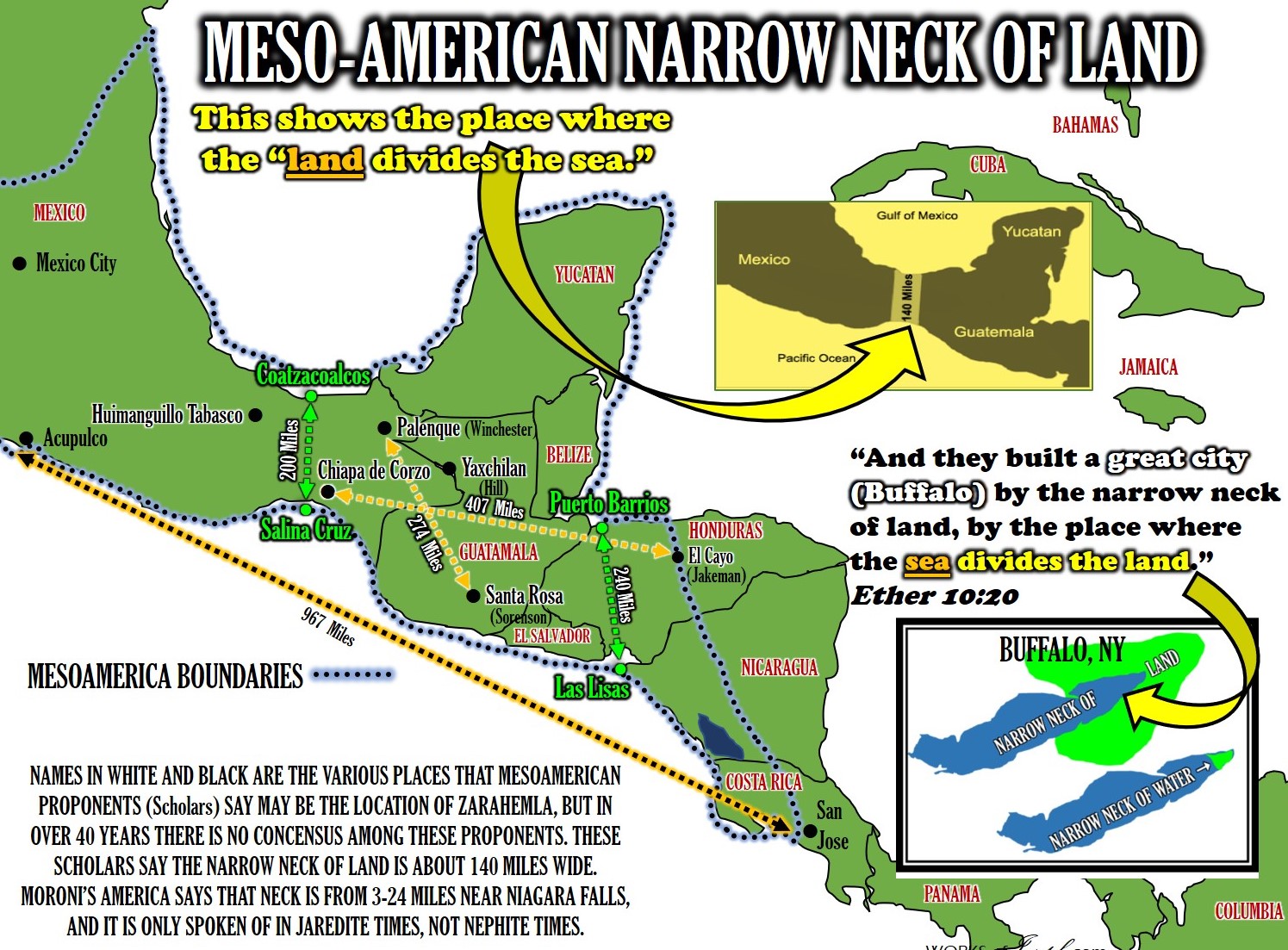
Furthermore, the narrow neck of land in Mesoamerica is over 100 miles wide. Many people have observed the incongruity of describing such a wide stretch of difficult terrain as “narrow.” A feature this wide might appear “narrow” from a satellite, but to someone on the ground, this Isthmus is as wide as the adjacent land.
When we read the text, we need to put ourselves in the place of the authors, in their time and place. They didn’t have satellites. They described their territory as they saw it, from the surface. Perspective is key.
[i] John L. Sorenson, “Digging into the Book of Mormon: Our Changing Understanding of Ancient America and Its Scripture,” parts 1 and 2, Ensign, September and October 1984. Available online at http://bit.ly/Moroni119 and http://bit.ly/Moroni120. Brother Sorenson wrote several other pieces for Church magazines on this topic.
[ii] Sorenson, Mormon’s Codex, pp. 21-22.
[iii] John L. Sorenson, An Ancient American Setting for the Book of Mormon (FARMS 1985), 11. Online at fairmormon.org, http://bit.ly/Moroni139.
[1] In the year 2000, John Sorenson published Mormon’s Map, an overview of what The Book of Mormon text says about geography. He writes, “The nearest thing to a systematic explanation of Mormon’s geographical picture is given in Alma 22:27-34… He [Mormon] must have considered that treatment full and clear enough for his purposes, because he never returned to the topic.”[1] Sorenson takes the approach of creating an abstract map based on The Book of Mormon text, and then seeing if it fits in a real-world location. I agree with Sorenson about the importance of Alma 22, as well as the utility of creating an abstract map and finding a fit in the real world.
 However, Sorenson’s analysis of Alma 22 seems to be influenced by the Times and Seasons article published on 1 October 1842, which declares that the Nephite city of Zarahemla “stood upon” “Central America or Guatimala [sic].” Sorenson cites this passage from the Times and Seasons, although he recognizes the “fact that the geography question had not been settled authoritatively.”[1] In Mormon’s Codex, Sorenson relegates the Times and Seasons articles to a footnote in support of his unequivocal conclusion: “Joseph Smith became convinced in the last years of his life that the lands of the Nephites were in Mesoamerica.”[1]
Sorenson’s assumptions about Central America lead him to a preconceived concept of Book of Mormon geography; i.e., a narrow neck of land between two larger land masses. Perhaps he felt somewhat bound by the Times and Seasons articles and his inference that Joseph Smith agreed with them. As such, Sorenson’s work could be viewed as an effort to vindicate the Prophet’s words. Page 31
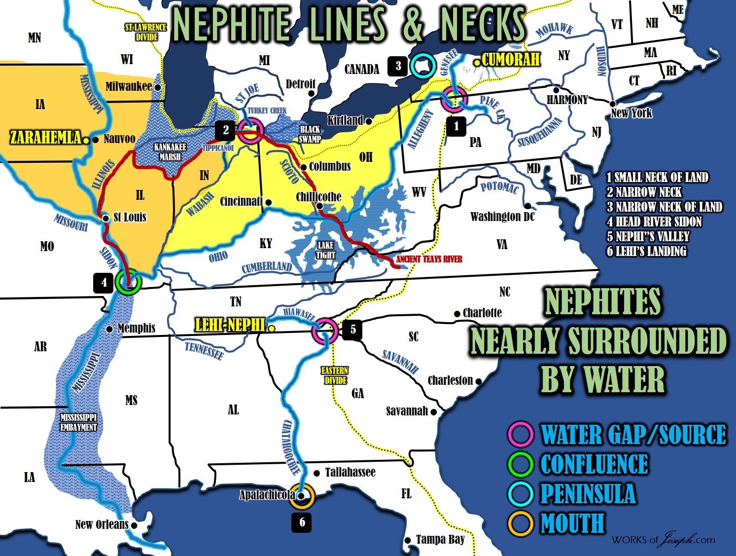
NARROW NECK- Where Hagoth built his ships. On Lake Michigan lower east side following Lake Michigan’s coast along the St Lawrence Continental Divide to the St. Joe River. Anciently the Grand Kankakee Marsh extended south of Lake Michigan and the Great Black Swamp extended west of Lake Erie. The neck running E/W was 30 miles between Warsaw, IN and Merriam IN. Alma 63:5
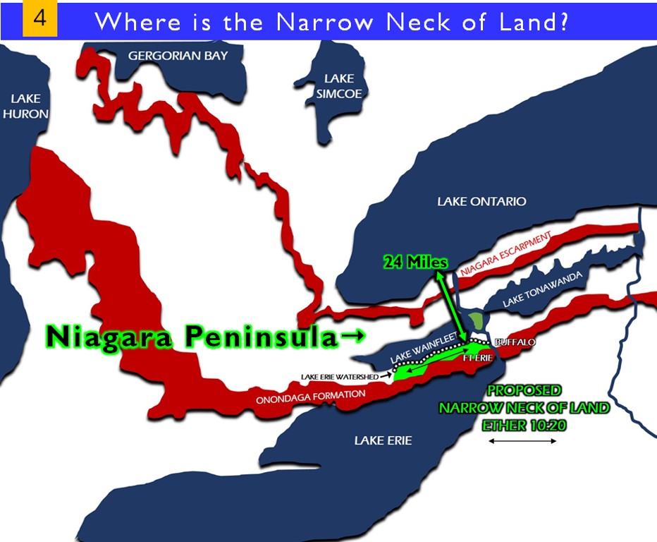
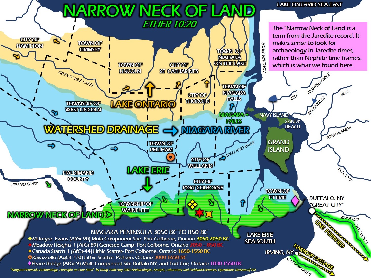
NARROW NECK OF LAND- Lake Ontario divides the land at Hamilton, OT Canada, and Lake Erie divides the land at Buffalo, NY, and at Toledo, OH. In Central America the ”land divides the sea”. (Isthmus of Tehuantepec) Lake Ontario and Lake Erie are seas, where the “sea divides the land” as quoted in Ether. Ether 10:20. The N/S distance from Lake Erie to Lake Ontario is only about 24 miles wide.
SMALL NECK OF LAND- Allegheny, Susquehanna, and Genesee head-river gaps. (Triple Divide) Only 6 miles between each of these three river heads, where the two Continental Divides meet. (St Lawrence and Eastern Divide) Anciently this location was called the Forbidden Path, and was a strategic defensive location, hunting area, and buffer zone for the Native Americans to protect their south land. “Leading directly into the heart of the central New York Iroquois heartland, the Forbidden Path stood at a strategic transportation break linking river systems ultimately flowing into Chesapeake Bay, the Great Lakes, and the Ohio Valley.” (Journey on the Forbidden Path: Volume 89, Part 2 By Christian Frederick Post, John Hays) Alma 22:32. This is the gate of the Narrow Strip of Wilderness and the place which is the “Nearly” in “nearly surrounded by water.” Don’t confuse this location with the more well known, “Narrow Neck of Land.” (3 “NECKS” see # 3,4,5).
There are 3 unique mentions in the Book of Mormon about NECKS!
- NARROW NECK OF LAND Ether 10:20
- NARROW NECK Alma 63:5
- SMALL NECK OF LAND Alma 22:32
These three unique mentions of NECK are all in different locations in North America. THE NARROW NECK OF LAND is defined below:
Lake Ontario (a sea) divides the land at Hamilton, OT Canada, and Lake Erie (s sea) divides the land at Buffalo, NY.
In Central America, the ”land divides the sea”. (Isthmus of Tehuantepec) which is opposite of what the scripture says about the “sea divides” the land.
Lake Ontario and Lake Erie are seas, where the “sea divides the land” as quoted in Ether. Ether 10:20. The N/S distance from Lake Erie to Lake Ontario is only about 24 miles wide and in Central America it is 140 miles, which doesn’t sound very narrow to me. In the Book of Mormon the Narrow Neck of Land is only described in the Book of Ether, so the Jaredites used it, not the Nephites. There is archaeological verification at the Niagara Peninsula that dates from 800 BC to 3000 BC which is the time of the Jaredites.
Main Map of the Narrow Neck of Land
This map below is the most clear map to view the Narrow Neck of Land. See the bright green figure below. This is only 3 miles wide from North to South. From the North of Lake Erie to the South shore of Lake Ontario is a total of 24 miles. My thesis says the Jaredites could travel from East to West along the (bright green figure), which runs on the north side of Lake Erie between the Lake itself and Lake Wainfleet which was an ancient time period lake. If Lake Wainfleet was dry that area would still be the watershed area (white dotted line) of today’s rivers that flow south into Lake Erie. You can see the Onondaga Formation extends the entire shore of Lake Erie and the Niagara Escarpment runs along the south shore of Lake Ontario, which are two huge obstacles for a Jaredite to transverse.
Moroni’s America-Heartland Map Package- BOTH MAP Book’s (210 Maps) + TRAVEL MAP Save 18%
was $42.85 now! $34.95- Click Here!
Maps and Text by Rian Nelson