
ABSTRACT A STUDY OF THE HILL CUMORAH: A SIGNIFICANT LATTER-DAY SAINT LANDMARK IN WESTERN NEW YORK Cameron J. Packer Religious Education Master of Arts
“Early Church member W. W. Phelps wrote, “Cumorah.. .is well calculated to stand in this generation, as a monument of marvelous works and wonders” (Latter-day Saints’ Messenger and Advocate, November 1835, 2:221). With a stately monument of the Angel Moroni cresting its summit, and a yearly pageant commemorating salient events associated with the coming forth of the Book of Mormon, it is fulfilling the exact role that Phelps envisioned. However, the general population of the Church is relatively unfamiliar with the history of this significant Latter-day Saint landmark. The following thesis is an in depth study and documentation of certain historical aspects of the Hill Cumorah as a significant, sacred geographic location to members of The Church of Jesus Christ of Latter-day Saints.

BACKGROUND INFORMATION “Man becomes aware of the sacred because it manifests itself, shows itself, as something wholly different from the profane.”1 To Latter-day Saints, the Hill Cumorah is an example of a place that has become different from its surrounding area. The following briefly outlines the pertinent information regarding the land that contains the hill held in reverence by The Church of Jesus Christ of Latter-day Saints. Physical Description Although the state of New York is currently one of the most eastern of the United States, in the early colonial days, western New York was still Indian territory and considered the western frontier of that day. One of the earliest descriptions of this frontier, which contained the Hill Cumorah, comes from Lewis Evans, a geographer and mapmaker of the early 18th Century. After observing the terrain that was occupied by the Iroquois Indians that included western New York, he wrote: To look from these Hills into the lower Lands, is but, as it were, into an Ocean of Woods, swelled and deprest [sic] here and there by little Inequalities, not to be distinguished, one Part from another, any more than the Waves of the real Ocean. The Uniformity of these Mountains, tho’ debarring us of an Advantage in this Respect, makes some Amends in another. They are very regular in their Courses, and confine the Creeks and Rivers that run between; and if we know where the Gaps are, that let through these Streams, we are not at a Loss to lay down their most considerable Inflections.2 From a higher vantage point, the land that contains the Hill Cumorah does, indeed, appear to be filled with “waves.” These waves, of course, are the hills of upstate New York. These hills, technically referred to as drumlins, are “regular in their courses” in that almost all of their long axes run in a north/south direction. The prevailing theory for this phenomenon is that drumlins are a result of glacial movement across the surface of the earth. When the glacier came in contact with a friction point, it deposited the sand, gravel, clay, and other debris along behind the friction point.3
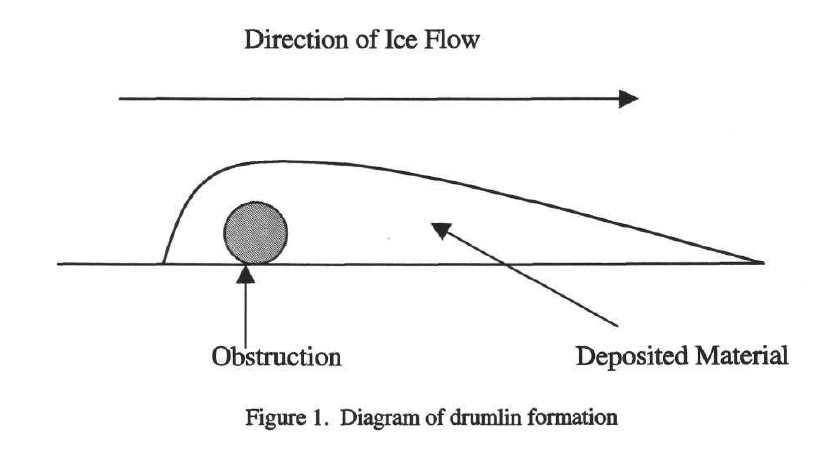
Figure 1. Diagram of drumlin formation
In further describing drumlins, one geology text states the following: Individual drumlins come in all sizes. Mostly they are highly elongated, stretching parallel with the direction of ice movement for 3 km or more. They may be over 100 m or less than 10 m in height. Generally they have rather blunt rounded up-glacier ends and more elongated ‘tails’…. Quite often drumlins exist in dense ‘swarms’, showing that they probably grow in response to a particular set of subglacial environmental conditions.4 It is within these “swarms” of drumlins that we find the Hill Cumorah. The area between Rochester and Syracuse contains around 10,000 drumlins, with about 1,000 in the Palmyra vicinity alone, making it one of the largest drumlin fields in the world.5 A geo-hydrology report in the Church’s Real Estate Department gives further information regarding this specific drumlin field: Hill Cumorah and the surrounding terrain are remnant deposits of the great ice cap which covered the northern part of North America during the early. Quaternary time. Linear shaped hills of clayey and silty alluvium called till because of their ice origin, have been deposited over northern New York State in the form of drumlins. These drumlins are aligned near parallel to magnetic north and vary in height up to as much as 200 feet. Hill Cumorah is one of these being a little over 100 feet high (elevation 700 feet above mean sea level), and surrounded by moderately sloping small valleys with elevations ranging from 570-580 feet. The unconsolidated sediments of silt, clay, sand and gravel with interspersed boulders, comprising the valley bottom and slopes, and the drumlins are a mantle approximately 40-200 feet thick. The larger number includes the higher and thicker section of the drumlins. The ancient topography of the underlying bedrock is moderate within the Hill Cumorah part of Ontario County, but the southern and especially southwestern part of the county is comprised of many ancient ravines and ridges… Apparently, the drumlins represent the filling of crevasses within the ice mass which were aligned in the direction of ice movement. After the confining ice melted away, the drumlins slumped along their sides, with the northerly ends to be the last to have their supports removed, and thus, today the steeper slopes.6 The topographical map in the Appendix, page 155 of this work, shows the Hill Cumorah and some of the surrounding drumlins that are part of this particular drumlin field. As far as the appearance of the Hill Cumorah in the early Eighteenth Century, Oliver Cowdery provided some of the earliest accounts. In 1830, he visited the hill and wrote at least two descriptions. The first, in the July 1835 issue of the Latter-day Saints Messenger and Advocate states: “You are acquainted with the mail road from Palmyra, Wayne county, to Canandaigua, Ontario county, New York, and also as you pass from the former to the latter place, before arriving at the little village of Manchester, say from three to four, or about four miles from Palmyra, you pass a large hill on the east side of the road. Why I say large, is because it is as large perhaps, as any in the country. To a person acquainted with this road a description would be unnecessary, as it is the largest and rises the highest of any on that route. The north end rises quite sudden until it assumes a level with the more southerly extremity, and I think I may say an elevation higher than at the south a short distance, say half or three fourths of a mile. As you pass toward Canandaigua it lessens gradually until the surface assumes its common level, or is broken by other smaller hills or ridges, water-courses and ravines. I think I am justified in saying that this is the highest hill for some distance round, and I am certain that its appearance, as it rises so suddenly from the plain on the north, must attract the notice of the traveler as he passes by.” 7 A few months later, in October 1835, he again elaborated: “The hill of which I have been speaking, at the time mentioned, presented a varied appearance: the north end rose suddenly from the plain, forming a promontory without timber, but covered with grass. As you passed to the south you soon came to scattering timber, the surface having been cleared by art or by wind; and a short distance further left, you are surrounded with the common forest of the country. It is necessary to observe, that even the part cleared was only occupied for pasturage its steep ascent and narrow summit not admitting the plow of the husbandman, with any degree of ease or profit.” 8 The Christian Register, in 1831, corroborates Cowdery’s description: “This hill has since been called by some, the Golden Bible Hill. The road from Canandaigua to Palmyra runs along its western base, at the northern extremity the hill is quite abrupt and narrow. It runs to the south for half a mile then spreads out into a piece of broad table land, covered with beautiful orchards and wheat fields. On the east, the Canandaigua outlet runs past it on its way to the beautiful village of Vienna in Phelps. It is profusely covered to the top with Beech, Maple, Bass, and Whitewood—the northern extremity is quite bare of trees.” 9 These three accounts are all very similar, especially with their description of the rather barren, northern end of the hill. According to Dr. James L. Baer, emeritus professor of geology at Brigham Young University, this lack of natural forestation is due to the steep angles characteristic of the northern ends of drumlins. The northern exposure that this end of the drumlin receives is also not conducive to the growth of the sub-alpine variety of trees that grows indigenous to the Palmyra-Manchester region.10
 Current Subscribers watch Here New subscribers sign up here

Figure 2. ca. 1920 photograph from the north ascent of Cumorah, looking north. Palmyra Bean Packer Collection, Provo, Utah.
The hill lies about 3.0 miles southeast of the Joseph Smith, Sr., farm, and 4.0 miles south of the village of Palmyra (road distance). When traveling north from Canandaigua to Palmyra on New York State Highway 21 (also known as Canandaigua Road) the hill is on the east side.11 Pre-Colonial and Colonial Era After Moroni buried the gold plates in the side of the drumlin called Cumorah, it, and its hidden record, became lost to the knowledge of humankind. The first human contact with the hill after Moroni seems to be that of the Native Americans that assumed control of the area prior to the colonization of America. This region of western New York containing the Hill Cumorah was formerly known as “Genesee Country,” and when the first Dutch settlers arrived in this area in 1609, it was controlled by the Seneca tribe of Indians.12 The Seneca tribe was the strongest of several Indian nations that formed an alliance or league sometimes referred to as the Iroquois confederacy. The other tribes included in this alliance were the Mohawks, Oneidas, Onondagas, Cayugas, and later, the Tuscaroras. Together they dominated the New York area and formed a type of chain across the central part of New York with each tribe making up a link.14

Figure 3. Map of the Iroquois Nation, Harper’s Atlas of American History
These Indians, specifically the Seneca tribe that inhabited the land that now makes up Wayne and Ontario counties of New York, were intimately connected to the hills that made up their territory. In fact, the Seneca tribe’s original title was the “Great Hill People” due to the legend that they claim explains their origination. The legend states: The base of Genundewah Mountain, as it is usually called, they believed to have been encircled, when their nation was in its infancy, by a huge serpent, so vast in proportions as to coil himself entirely around the mountain. The head and tail of the monster united at the gateway of the path leading to and from the steep summit, and there were few who attempted to pass that escaped his voracious jaws. Thus environed, a long time elapsed, during which the people were not only besieged and reduced in numbers, but made to suffer from the poisonous breath of the reptile. Finally, their torment being beyond endurance, the Indians resolved to attempt a sally. Armed with such weapons as were at hand, they rushed down the hill towards the dreaded portal, where all were seized and swallowed with the exception of two children, who somehow contrived to overleap this fearful line of circumvallation, and so avoid the terrible fate of the tribe. These children, thus spared and orphanized, were reserved for a high destiny,—the destruction of the serpent. Mysteriously the information was imparted how this object could be accomplished. Direction was given to form a bow from a specified kind of willow, and an arrow from the same material. The barb of the arrow was to be dipped in poison and shot obliquely, to allow of penetration beneath the scales. Obeying divine injunction, the death of the serpent was effected. As the deadly arrow penetrated the skin, the huge monster was seized with violent convulsions. Uncoiled from around the mountain, and writhing in the most frightful contortions, the reptile threw up the heads of the people he had devoured, and rolled down the steep into the lake, sweeping down the timber in his course… From these two survivors sprang the new race of Senecas.15
0000 2022 LDS Living AD_FIRM Conference_April (4)Purchase Tickets Here
While this well known Genundewah hill is at the head of Canandaigua Lake, it is probably safe to assume that this same group of Indians were aware of the Hill Cumorah just a few miles north. John D. Giles, director of the Hill Cumorah Bureau of Information in the 1940’s, and one who did considerable research on the Hill Cumorah wrote about the connection between the Senecas and the Hill Cumorah: It is of more than ordinary interest, if not of real significance, that Hill Cumorah is in the heart of the lands of the League of the Iroquois, the Six Nations, with its federal system of government that made it not only the most influential of all Indian groups, but that the Hill is in the heart of the lands of the Senecas, most powerful and influential of the Six nations in the League of the Iroquois. To what purpose if any, early Senecas put the Hill, with its overview of surrounding country, is not known, but it seems reasonable to believe that, although it was not near any of the larger Indian villages it served as a lookout in times of trouble. One of the old Indian Trails which became the route of the first road of the white man in this area, from Canandaigua Lake, two miles south of the Hill to Lake Ontario twenty-two miles north passing the “nose” of the Hill Cumorah. The finding of Indian arrow and spearheads in great quantities on the slopes of the Hill and in the fields surrounding it indicates that long after the great battle in which the Nephites were annihilated Hill Cumorah has been an important battle ground.16 Willard Bean’s17 experience coincides with Giles’ conclusion as he found many arrowheads and artifacts as he visited and worked on the Hill Cumorah in the early 1900’s. Some of these are shown below.

Figure 4. Collection of arrowheads found at or near the Hill Cumorah, Palmyra Bean Packer Collection.
Phelps/Gorham Purchase According to the Treaty of 1763, the land upon which the Hill Cumorah stood was still part of Indian territory, although title to the land had long been in dispute by the English, French, and the Dutch who each granted it out to different colonists.18 After the War of Independence, both the Massachusetts and New York colonies laid claim to the Genesee Country (western New York including the Finger Lakes region). On 16 December 1786, representatives of both colonies met at Hartford, Connecticut to work out an agreement over the disputed land. Part of the settlement “gave to New York the sovereignty of all the disputed territory within her chartered limits, at the same time giving Massachusetts title in the soil, or the right to buy the soil from the Indians, who were then in actual possession.”19 This gave Massachusetts the right to sell the land after which it would revert back to the control of the colony of New York. Massachusetts then sold this pre-emption right to all six million acres to two men named Oliver Phelps and Nathaniel Gorham for $1,000,000.21

Figure 5. Map of Phelps and Gorham Purchase, Vanderhoof, Historical Sketches of Western New York, 233. Although Phelps and Gorham had purchased the pre-emption rights they still had to officially purchase the land from the current inhabitants, the Iroquois, namely Seneca, Indians.22 Oliver Phelps was put in charge of negotiating with the Indians and a meeting was scheduled with them at Kanadesaga, which is now the city of Geneva.23 On July 4, 1788, Phelps and his party met with a group of Indian chiefs headed by Red Jacket, representing the Senecas, Oneidas, and Tuscaroras whose lands were the principal object of the purchase.24 After several days of bargaining the Indian chiefs agreed to sell 2,600,000 of the 6,0000,000 acres to Phelps and Gorham for the price of $5,000 down and an annual payment of $500 forevermore.25 In 1789, Oliver Phelps opened the first official land office in Canandaigua and began dividing the land into townships and ranges.26 Ontario County, which includes Manchester township where the Hill Cumorah lies, was formed from Montgomery County in 1789. 27 (Manchester township was not organized until March 31,1821). From the time the land office was opened, settlers came in rapidly to this new area, attracted by the beautiful country and fertile soil.28 The early settlers to Ontario County were mostly from New England. According to one source, three fourths of all the men were former Revolutionary War soldiers. Some of these men had previous knowledge of the Genesee country as they had been with General Sullivan on his 1779 campaign through the area to quell hostile Indian activity. While there, they had taken note of the fertility and beauty of the Indian lands they traveled through, and were amongst some of the first settlers when the land opened up for settling.30 This 2,600,000 acres of land purchased by Oliver Phelps and Nathaniel Gorham and settled in large part by former Revolutionary War veterans included the hill out of which the Prophet Joseph Smith would remove the gold plates in 1827.
Notes
1 Eliade, The Sacred and the Profane, 11.
2 Lewis Evans, Geographical, Historical, Political, Philosophical and Mechanical Essays. The First, Containing an Analysis of a General Map of the Middle British Colonies in America; and of the Country of the Confederate Indians: A Description of the Face of the Country; the Boundaries of the Confederates; Several Rivers and Lakes Contained Therein. (Philadelphia: B. Franklin, and D. Hall, 1755), 5-6.
3 Richard H. Jackson, “Hill Cumorah,” in Historical Atlas of Mormonism, ed. Donald Q. Cannon, S. Kent Brown, Richard H. Jackson (New York: Simon & Schuster, 1994), 8. When the glacier retreats, it is smaller and lighter and, therefore, melts around the drumlins it had previously formed rather than scraping or flattening them down. Personal Interview with Dr. James L. Baer, emeritus professor of Geology, Brigham Young University, 13 August 2002.
4 Brian S. John, The Ice Age: Past and Present (London: William Collins Sons & Co Ltd., 1977), 73.
5 P. Jay Fleisher, “Geology of the Wine Country of New York,” in Glacial Geology and Geomorphology of North America, ed. Penelope M. Hanshaw, Glacial Geology and Geomorphology of North America (Washington D.C.: American Geophysical Union, 1989), 29.
6 Geo-Hydrology Report contained in the “Hill Cumorah” files, file number 505-4907, located in the Real Estate Department of The Church of Jesus Christ of Latter-day Saints, Salt Lake City. See also, Jackson, “Hill Cumorah,” As far as an exact measurement of the height of Cumorah, Larry C. Porter, with the aid of a Global Positioning System, has calculated the height of the peak to be about 117 feet above ground level, see LaMar C. Berrett, ed.. Sacred Places: A Comprehensive Guide to Early LDS Historical Sites, vol. 2, New York and Pennsylvania (Salt Lake City: Deseret Book Company, 2000), 155.
7 Oliver Cowdery, Latter-day Saints Messenger and Advocate, July 1835,1:158.
8 Cowdery, Latter-day Saints Messenger and Advocate, October 1835,2:195 196.
9 “Mormonism,” Christian Register, 24 September 1831.
10 James L. Baer, Personal Interview, 13 August 2002. Dr. Baer explained that the trees mentioned in the Christian Register are known as “sub-alpine” and struggle to grow on the steep, northern exposed ends of drumlins in that area, but thrive on the other, more lenient slopes.
11 Larry C. Porter, “A Study of the Origins of the Church of Jesus Christ of Latter-Day Saints in the States of New York and Pennsylvania, 1816-1831” (Ph.D. diss., Brigham Young University, 1971), 24-5.
12 E.W. Vanderhoof, Historical Sketches of Western New York (New York: AMS Press, 1907), .
13 George W. Cowles, Landmarks of Wayne County, New York (Syracuse: D. Mason & Company, 1895), 19, and W.H. Mcintosh, History of Ontario Co., New York (Philadelphia: Everts, Ensign & Everts, 1876), 9, and Orsamus Turner, History of the Pioneer Settlement of Phelps and Gorham’s Purchase and Morris’ Reserve (Rochester: William Ailing, 1851), 109. See also, Willard W. Bean, A.B.C. History of Palmyra and the Beginning of “Mormonism” (Palmyra: Palmyra Courier CO., Inc., 1938), 5.
14 Vanderhoof, Historical Sketches of Western New York, 1, see also. Harper’s Atlas of American History (New York: Harper & Brothers Publishers, 1920), 6,11,13.
15 Mcintosh, History of Ontario Co., New York, 9.
16 John D. Giles personal writings, in John Davis Giles Collection (LDS Church Archives, Salt Lake City), Box 6, reel 5, folder 12, original spelling and punctuation retained. The writer has access to a number of arrowheads found on and around the slopes of the Hill Cumorah that were found in the early 1900’s (see visual), courtesy of the Palmyra Bean Packer Collection, Provo, Utah. Alvin P. Bean corroborates the finding of these arrowheads as he is one that personally found many on and around the hill in the 1920′s-30’s. Personal Interview, Orem, Utah, 24 October 2002.
17 Willard Washington Bean was the caretaker of the Joseph Smith farm from 1915-1939. 18 Harper’s Atlas of American History, 16. See also, Vanderhoof, Historical Sketches of Western New York, 7, and Cowles, Landmarks of Wayne County, New York, 15, and Turner, History of the Pioneer Settlement of Phelps and Gorham’s Purchase and Morris’ Reserve, 105.
19 Cowles, Landmarks of Wayne County, New York, 15.
20 Bean, A.B.C. History of Palmyra and the Beginning of “Mormonism”, 6.
21 Cowles, Landmarks of Wayne County, New York, 18, also Child, ed.. Gazetteer and Business Directory of Ontario County, N.Y.for 1867-8, 29-30.
22 Cowles, Landmarks of Wayne County, New York, 20.
23 Mcintosh, History of Ontario Co., New York, 16.
24 Mcintosh, History of Ontario Co., New York, 13.
25 Cowles, Landmarks of Wayne County, New York, 20, according to Cowles, this equaled about a half cent an acre. See also Child, ed.. Gazetteer and Business Directory of Ontario County, NY. for 1867-8, 29-30, also Bean, A.B.C. History of Palmyra and the Beginning of “Mormonism”, 6.
26 Mcintosh, History of Ontario Co., New York, 17.
27 Horatio Gates Spafford, A Gazetteer of the State of New York (Albany: H.C. Southwick, 1813), 91, Child’s Gazetteer gives the exact date as 27 January 1879, see Child, ed.. Gazetteer and Business Directory of Ontario County, NY. For 1867-8, 21,29-30.
28 Child, ed.. Gazetteer and Business Directory of Ontario County, N.Y. for 1867,21,29-30. Cowles claims that many soldiers who accompanied General Sullivan on his campaign through western New York in 1779 to quiet Indian troubles, saw this territory as “the Canaan of the wilderness,” and helped to portray the Genesee country as a favorable place to homestead to those in the colonies, see Cowles, Landmarks of Wayne County, New York, 14-15.
29 Vanderhoof, Historical Sketches of Western New York, 10. 0 Cowles, Landmarks of Wayne County, New York. 14-15. Bean states that another group of settlers into the northern part of Ontario County was the group led by Jonathan Swift and John Jenkins from the Wyoming Valley of Pennsylvania, see Bean, A.B.C. History of Palmyra and the Beginning of “Mormonism “, 9-11.
Source: https://pdfs.semanticscholar.org/ad86/6fd47d990b643fd8a55175ba1272daade902.pdf
For additional information see my blog titled: “Letter 12-Cumorah, the Artificial Hill of North America”


