
Our Friends Wayne May, Mike and Betty LaFontaine, John Lefgren, Richard Moats, Mike Baker, Jeff Green, Ryan Sorensen, Kevin Price and more are in Montrose Iowa for the past few weeks searching for signs of ancient civilization that dates to the Book of Mormon times.
On the west side of the Mississippi just 1/4 mile south of the possible Zarahemla Temple Site in Montrose, Iowa, the Heartland Research Team have scanned hundreds of acres of farm land with Magnetometry and hope to find significant numbers of ancient Roundhouses, Fire Pits and Post Holes below the surface of the earth.
.png/:/rs=h:650,cg:true,m)
Dateline — Montrose, Iowa, November 13, 2020.
This morning the Fort Madison Democrat had on its front page a report on the German technology coming to Iowa.

| Science students from Central Lee Community School came to Jim’s Greenhouse in Montrose to learn about the application of a technology that comes from Germany. The technology is designed for discovering evidence of ancient habitation in the fields of Lee County. The Heartland Research Group, in cooperation with SENSYS engineers, demonstrated the world-class equipment to science students on a local farmland. Last week the SENSYS MV X3 came by air and land from Berlin to Montrose. Europeans have used this same equipment to enlarge the world’s understanding of Stonehenge in England, the discovery of Roman cities in Spain, the campgrounds of Legionnaires in the Danube River valley, and the unearthing of Viking ships in Norway. Yesterday the German technology located evidence of human habitation in Montrose that is more than one thousand years old. This was the first application of modern technology for discovering roundhouses and firepits of ancient people who lived on the western banks of the Mississippi. How is the technology able to locate the exact positions of ancient human activities in the ground? We know for certain that Native People thousands of years ago cooked food, brought light to their rooms and warmth to their homes with the keeping of fires. The heat from these ancient fires changed the magnetic signature of the soils and rocks. The changes in these magnetic signatures are still in the ground. The SENSYS scanning produces gray-scale magnetic images that are comparable in its details to MRI scans of the human body. The German equipment measures fine magnetic forces at an extremely fast rate. The science students saw the collection of data from a field that has evidence of ancient habitation and activities under the ground’s surface that is three miles from the Central Lee Community School District. The Research Group has organized its efforts as a serious scientific project involving the talents of 15 people who have more than 400 years of professional experience. The group of talented people has come together to make magnetic scans of lands. The scans have 16 unique data values in a space that is one-quarter of an inch by one-quarter of an inch. A data set includes the fine measurement of magnetic force (nano-Telsa) with two GPS coordinates for each point of observation. Within a two week timeframe, it is possible to collect, store, and digitally plot about 100,000,000,000 points. The research’s primary focus is to identify variations in the gradients of the nano-Tesla levels to locate fire pits, post holes, roads, and other changes that native people made in the soil as they lived their lives more than a thousand years ago. The Research Group believes that the river’s west bank in the area of the Des Moines Rapids had an ancient population that could have been greater than today’s population. The world’s best sensing technology records from about three feet under the ground data that outlines the pre-European history of our local area. The German Company SENSYS has demonstrated the capability of its technology at several sites in Europe and Africa. The Research Group is pleased to sponsor the application of this technology in community. The results will be of great interest and that they will only add to the legacy of the lands. The research is entirely non-invasive. The technology does not turn a shovelful of dirt. There is no more effect on the ground than if a Boy Scout had used a compass to orient his map. The success of the search depends entirely upon the science that produces exact measurements. The SENSYS fluxgate tube can measure one-billionth of a Tesla (one nano-Tesla). The earth’s magnetic force is 50,000 nano-Teslas. So, the SENSYS machine is about 1/50,000th as sensitive as that force that moves a compass needle. This fineness of measurement makes it possible to locate the activities of people who lived thousands of years ago. These measurements are beyond the understanding of any scientist or engineer from a past generation. That is how far modern science has taken us. The technology will add to the history of the lands in Lee County. Dateline — Montrose, Iowa, November 14, 2020. Today clear evidence of significant features sprang out of cornfields that are in Montrose, Iowa. The SENSYS MV X3 unveiled from the ground earthworks that date to the timeline of the Book of Mormon. Fourteen people from the Heartland Research Group are involved in this search. Together they have 400 years of professional experience in science, history, digital imaging, and other disciplines. The new evidence is ancient and significant. The area of interest is more than 200 acres. On Monday the scanning team will continue to make more digital images that will come out of the earth. Serious students of the Book of Mormon may mark this day as an time when physical truth began to come out of the earth to confirm the existence of the Great City of Zarahemla. Doubters may replace doubts with faith. 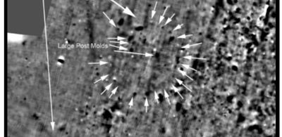 Above, 2,000-year-old, 64-ft Diameter, Round House. Post holes and fire pits. Found by Heartland Research Group 2018 Glenford, Ohio. Similar scans found in Iowa Nov 14, 2020 (Same scan as the one below)  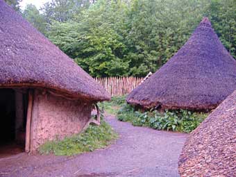 Ancient replica Adena Roundhouses. Ancient replica Adena Roundhouses. Above Aerial shot of Adena ceremonial circle at the Neibert Mound site, 1992. USACE/ Mason County, West Virginia Mockers will have a hard time to explain what until now was unseen in the ground for thousands of years. The Heartland Research Group is more than pleased with the results of today’s scans. We have spent years looking for such results. We have traveled the world looking for the right combination of technology and place. Today they came together. Tomorrow the truth will spring out of the earth in greater abundance. Praise God from Whom all blessings flow. More Information at https://zarahemla.site/ |
[…] Heartland during Book of Mormon Times. They have found Adena Roundhouses like the one above. Visit my blog here to read more about […]
Comments are closed.