It is amazing how many secondary evidences there are to the truthfulness of the Book of Mormon. There are thousand of artifacts both ancient and Hebrew, many references to the Book of Mormon saying in its own pages that it is the Promised Land of America, having the correct animals to obey the Law of Moses, the triple witness in Missouri where the Garden of Eden, New Jerusalem, and Adam -Ondi-Ahman existed or will exist. The Constitution was created by the Lord himself for these the United States, the Plates were buried here, the final battles were at Ramah and Cumorah, the same place, the headquarters of the Church is here, the first mission to the Lamanites in NY, OH, and MO., the same latitude of Tallahassee, Fla with Jerusalem 30 degrees to successfully plant seeds, the Wentworth Letter, and those listed other documents listed below.

The the many witnesses of Zelph and Joseph’s letter to Emma as he was wandering over the plains of the Nephites, to Manti in journals and now for the Des Moines Rapids at Zarahemla. Wow, It is over whelming to most of us isn’t it? I feel blessed to know these things and feel they make sense to me which is an additional witness to the testimony I have of this wonderful Book of Mormon.
Joseph Smith’s Historically Verifiable Written Statements
Nearly all those familiar with the early statements by the Prophet touching on potential Book of Mormon lands know that he clearly indicated them to be in North America. This is evident in the historically verified accounts wherein he declared revelation such as in the Wentworth Letter, the American Revivalist Account, the Zelph Accounts and Joseph’s handwritten letter to Emma while on Zion’s camp. In addition, the prophet revealed a Nephite altar at Adam-ondi-Ahman, mentioned the land of Manti was near Huntsville, Missouri, and revealed that this land was “the borders of the Lamanites” (see D&C 54:8). Furthermore he received revelation from the Lord for the location of Zarahemla (see D&C 125:3) and New Jerusalem (see D&C 84:1-6) which Christ Himself declared to be on Book of Mormon lands (3 Nephi 20:22), both of which are absolutely located in North America. These accounts and their indications are not speculation based, but historically documented.

Revelation given through Joseph Smith the Prophet, at Nauvoo, Illinois, March 1841, concerning the Saints in the territory of Iowa.
D&C 125:3-4 “Let them build up a city unto my name upon the land opposite the city of Nauvoo, and let the name of Zarahemla be named upon it.
And let all those who come from the east, and the west, and the north, and the south, that have desires to dwell therein, take up their inheritance in the same, as well as in the city of Nashville, or in the city of Nauvoo, and in all the stakes which I have appointed, saith the Lord.”
Could this have been the ancient city of Zarahemla?

Why did the Lord use this specific name from the Book of Mormon? That this was where Joseph was told to build up a city named Zarahemla can be seen in the map on page 394 of the Joseph Smith Papers, Journals Vol. 1 which shows the many tracts of land purchased by the saints on the western side of the Mississippi River across from Nauvoo as a result of this revelation.
No statement exists that confirms that the ancient city of Zarahemla was west of Nauvoo, however that does not rule out the possibility, and the Lord gave no indication the it was not its location or that the name given was only symbolic. He called it Zarahemla for a reason. He has an infinite number of names that He could have used, yet He used the specific name “Zarahemla.” If this was not the location of the ancient city of Zarahemla, why didn’t the Lord so indicate, as he did by distinguishing the Jerusalem in the Old World from the new by calling it “New Jerusalem.” Why wasn’t it called “New Zarahemla” if doing so was only symbolic.
The Des Moines Rapids
Exploring the Book of Mormon in America’s Heartland by Rod Meldrum pg. 80-81
“The Des Moines Rapids between Nauvoo, Illinois on the east and Montrose (Zarahemla) and Keokuk, Iowa on the west was formed by a hard natural limestone shelf that extended across an 11 mile stretch of the Mississippi river. It severely limited Steamboat traffic through the earl 19th century. Prior to the building of locks and dams that have raised water levels 18-20 feet, it was the first location upstream from the Gulf of Mexico where the Mississippi river could be crossed… on foot. Historical records state that these rapids had an average depth of only 2.4 feet*, with most of the crossing being more shallow, especially during late summer, fall and dry seasons…
*”The Mississippi in its natural state widens from 2,500 feet (760 m) to 4,500 feet (1,400 m) in width at Nauvoo as it drops 22 feet (6.7 m) over 11 miles (18 km) over shallow limestone rocks to the confluence with Des Moines. According to records its mean depth through the rapids was 2.4 feet (0.73 m) and “much less” in many places.” Wikipedia
Rodney L. Meldrum continues, “…Why is this important? This would have been one of the most strategic locations in North America due to this crossing of a significant barrier to travel, the Mississippi River. Trade would also occur here bringing goods and people together from across the continent.

This location would also be of strategic importance in securing against foreign invasion. An ancient army would of necessity be faced with either swimming or rowing their men across to launch an attack, which in the case of the Book of Mormon could mean many thousands of men awaiting portage. The element of surprise in battle would be lost if a week were required to ferry men across the river. This major river crossing would, then, be a critical strategic location either to defend of to conquer, by allowing or restricting access to either side.
CROSSING THE MISSISSIPPI ON HORSEBACK
On August 8, 1842, a Warrant was served by Governor Carlin for the arrest of Joseph Smith and Porter Rockwell who had been charged with the near fatal shooting of Gov. Lilburn Boggs. Joseph and Porter went into hiding, knowing their innocence and that this was just another attempt to thwart the work of the Lord.

From Dean C. Jesse’s The Papers of Joseph Smith, in the Illinois journal we read from the entry Aug. 11th, “It is very evident that the whole business is but another evidence of the effects of prejudice, and that it proceeds from a persecuting spirit, the parties having signified their determination to have Joseph taken to Missouri whether by legal or illegal means.” The journal continued, “12 August 1842 – Friday – This AM it appears still more evident that the whole course of Proceedings of Gov. Carlin and others is illegal”
A stratagem was conceived to trick the Sheriff and his Deputies. The journal states,” Accordingly Joseph’s new horse which he rides, (which he named Joe Duncan after the unsupportive former Governor of Illinois) was got ready and Wm. Walker proceeded to cross the river in sight of a number of Persons. One chief design in this procedure was to draw the attention of the Sheriffs and public, away from all idea that Joseph was on the Nauvoo side of the river.”
The next day, “A report came over the river that there is a several small companies of men in Montrose, Nashville, Keokuk, etc., in search of Joseph. They saw his horse go down the river yesterday and was confident he was on that side.” The Mississippi River was shallow enough on this late summer day to ride a horse across it at this location.” Exploring the Book of Mormon in America’s Heartland by Rod Meldrum pg 80-81

Edward Phillips
“I have a Patriarchal blessing hanging in a frame in my room, which was pronounced upon my head by the prophet and patriarch, Hyrum Smith, in the fall of 1844[1843?], which is worth more than gold to me – Gold is no name for it. The predictions are being literally fulfilled every day. I know if I prove faithful it will all come to pass. I knew then and also know now that Joseph was a true prophet of God, and that the mantle of Joseph fell on Brigham Young who was his legal successor.
I was present at the meeting when this took place and heard with my own ears and saw with my own eyes. We all thought Joseph had come back to us although we knew he was in his grave. I was standing by the temple talking to Brother Woodruff and he pointed out a spot to me on the opposit[e] side of the river about a mile and a half above Montrose, and said there would be a city and a temple built there and the place would be called Zarahemla. I was at Nauvoo when the temple was finished and dedicated. I went up into the tower and wrote my name there. As I understand, the wicked have burned that temple to the ground and it is all destroyed like the Jerusalem temple. But I expect to see that temple re-erected and the one built on the opposite side of the river to match.” Autobiography of Edward Phillips (1813-1896)

Moroni’s America by Jonathan Neville
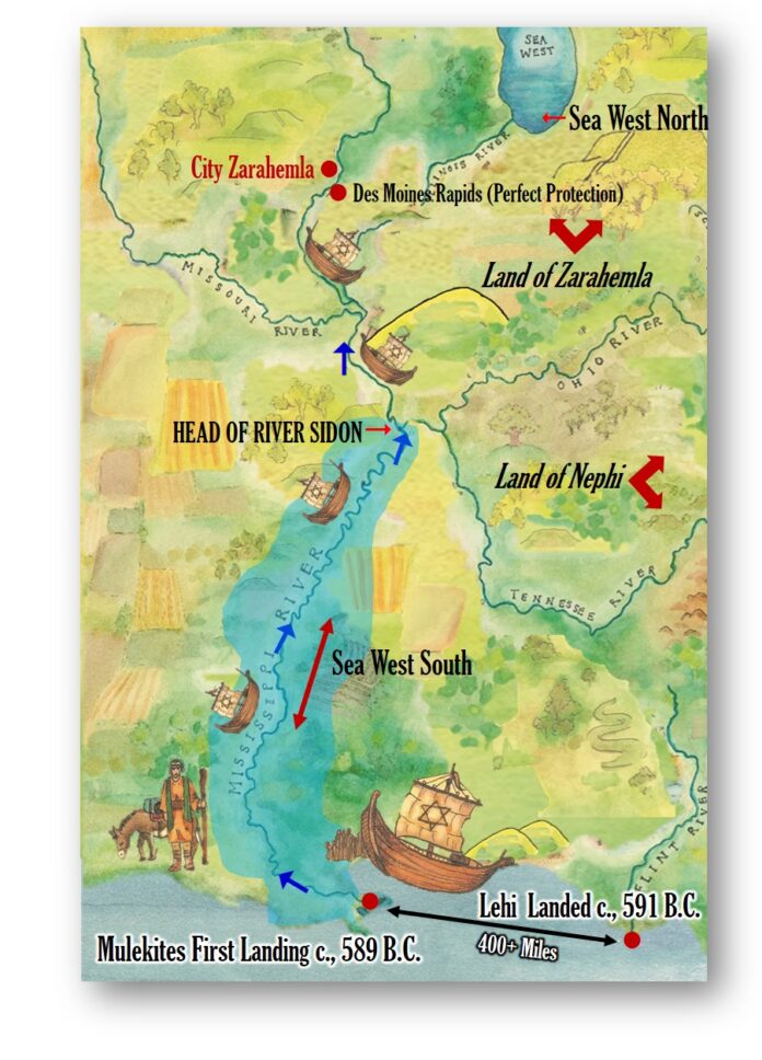
There is a good reason why the Mulekites would have stopped in Iowa, across from Nauvoo. It is the first place up the Mississippi river from the Gulf Coast that, historically, was impassable for large ships, due to the Des Moines rapids located just south of there. Even in the 1840s, riverboats had to stop at the rapids, unload cargo, and then be dragged over the rapids before progressing north. (Now, a series of dams and locks makes the river navigable for barges and other large ships.) Lewis and Clark noted the rapids on their 1814 map. In 1837, Robert E. Lee made a map showing the rapids by Fort Des Moines, where Montrose, Iowa, is today.
Figure 18 shows another key point. The Mulekites could have easily sailed up the river without encountering the Nephites or the Lamanites, who were several hundred miles east. Furthermore, the Mulekites would have sailed right past other civilizations that likely existed in the area, descendants of Jaredites or other groups who had come to the continent.
The Zarahemla location in Iowa, across from Nauvoo, is ideal from several perspectives. First, being on the river provides plentiful water and facilitates commerce. Second, it is upriver from the Des Moines rapids, which provide a defensive barrier against river-borne invaders from the south. Third, the area has productive agricultural land. Ultimately, of course, it’s where the Lord led them.
This geography helps clarify why the Nephites never encountered Zarahemla until Mosiah was prompted to flee from the land of Nephi. In our day, we might think people would explore freely, but anciently, the wilderness was dangerous. There were wild beasts, unpredictable weather, the potential of getting lost, sicknesses, and no way to communicate over long distances. You were on your own in the wilderness. By contrast, there was safety in numbers and community. Farms provided food. Why risk leaving a safe, productive and favorable location?
It required great faith for Lehi and his family to leave Jerusalem, let alone cross the ocean (which is why Nephi faced such resistance from his brothers). In the new world, it required great faith for Nephi to flee from his brothers into the wilderness. Mosiah exercised great faith to leave the land of Nephi.
The prominence of Zarahemla—it is by far the most-often mentioned place in the Book of Mormon, the capital of the Nephites—shows it was wise for the people of Zarahemla to stay put. Moroni’s America page 100-101
Historical Des Moines Rapids
The Des Moines Rapids between Nauvoo, Illinois and Keokuk, Iowa-Hamilton, Illinois is one of two major rapids on the Mississippi River that limited Steamboat traffic on the river through the early 19th century.
The rapids just above the confluence of the Des Moines River were to contribute to the Honey War in the 1830s between Missouri and Iowa over the Sullivan Line that separates the two states.

Various attempts to make the river navigable started in 1837 when a channel was blasted through the rapids by U.S. Army Corps of Engineers team led by Robert E. Lee. A canal around the rapids was built in 1877. It is now obliterated by Lock and Dam No. 19.
The other major rapids barring traffic on the Mississippi is the Rock Island Rapids.
The Mississippi in its natural state widens from 2,500 feet (760 m) to 4,500 feet (1,400 m) in width at Nauvoo as it drops 22 feet (6.7 m) over 11 miles (18 km) over shallow limestone rocks to the confluence with Des Moines.
According to records its mean depth through the rapids was 2.4 feet (0.73 m) and “much less” in many places.

Beginning in 1804 United States government-sponsored trading posts for Native Americans as part of the Native American factory system began being built at the rapids. Forts were associated with the trading posts including Fort Johnson, Fort Madison. The forts were burned during the War of 1812. After the war Fort [Edwards] was established and commanded by Zachary Taylor. Wikipedia
You are at the end of my blog. Each time I write a blog, here at the end I am going to discuss very important issues of what is going on in our world. It will be about our evil government, the stealing of our money, a Quantam Financial System, NESARA, the illegal trafficking of our children, evil worship of Satan, or new health ideas that are both evil and wonderful, about the IRS which is a foreign owned company or about our USA country as only a corporation, or the vaccine may be used to reduce our population, and I may speak how the enemy countries of the world who say they are our allies. If you want to join in a wake up you will be amazed. None of this information is on the mainstream news. NONE OF IT. I don’t want you to believe me, but do your own research and figure it out on your own. If you don’t you will have a very difficult time in the next months figuring out how our life has completely changed for the better. It’s all new systems but most of you won’t believe it. For personal articles on my own website visit www.worksofjoseph.com/blog
My clue for today that I want you to sit at your computer for 10 minutes to an hour, and use the following clues to tell me if you know what terrible evil happened last week and tell me about a possible war we averted.
Evergreen
H3RC
Suez Canal
WMD
Children
Please email me and tell me what happened briefly.


