
Hopewell/Nephites Important Similarities
The Hopewell Culture describes the common aspects of the Native American culture that began in the Florida panhandle in 600 – 500 BC that flourished along rivers in the northeastern and Midwestern United States from 300 BC to 400 AD, in the Middle Woodland period.
As you can see in the map below, and as you read history, the proven historical location and timelines of the Hopewell Culture are facts. Just think about it. If we found a people that had a history following this same beginning and ending pattern in North America and we called it the Book of Mormon, we would have validation that indeed the Hopewell people are the same as the Nephites. So as we surmise, Lehi landed in Florida, Nephi was chased by his brothers into Tennessee, then Mosiah left and went north on the Tennessee River (which by the way, flows north) to Missouri and Illinois where he met up with the Mulekites near the Mississippi River. Remember the Mulekites began their civilization at the same place they were found by Mosiah. (read here) “And they [Mulekites] journeyed in the wilderness, and were brought by the hand of the Lord across the great waters, into the land where Mosiah discovered them; and they had dwelt there from that time forth.” Omni 1:16

Because of being found where they landed, we show a great probability that the Mulekites followed the same path as Lehi to the Gulf of Mexico, with the Mulekites following the Mississippi River all the way up to Montrose Iowa, where the Des Moines river rapids halted their journey, as it restricted boat traffic until the Army Corps of Engineers opened that waterway in the 19th century.
The area of Ohio is known as the Cultural Center of both the Adena and the Hopewell People with the Great Hopewell road running from Chillicothe, OH to Newark OH, the place of the amazing Newark Earthworks.
In the Land Zarahemla (WI, IA, MO, IL), there were many battles as well as in the Land Bountiful, (IN, OH, PA, NY) from Illinois to Indiana to Ohio and finally at Cumorah. What happened near Cumorah historically? Historians have found a sudden end to Hopewell civilization and pottery in that area from about 400-500 AD. We Latter-day Saints know what happened in that time range as the Lamanites destroyed the Nephites.
For a Full Nephite Time-Line visit: https://bookofmormonevidence.org/nephite-timeline/
Origins, Mound Builders and Mormonism 1491 New Revelations of the Americas Before Columbus, Charles C. Mann
“The major metatheoretical issue in the pre-professional anthropology of Squier’s day was whether humankind had a single origin (monogenism, with Native Americans often assumed to be the ‘Lost Tribes of Israel’ or other people mentioned in the Bible) or whether the races had multiple origins (polygenism, with various kinds of non-whites viewed as being created separately and comprising inferior species).” The question being raised was: Who were the people who built such amazing earthwork structures and mounds? “The result was that mound construction was widely and popularly attributed to a race of [Mound Builders], who no longer existed or at least no longer existed where and as they had earlier.”

In the 1998 republication of the Squier and Davis report, David J. Meltzer states, “All this was riding on a book devoted to the questions of the origin, antiquity, and identity of the [Mound Builders].” Questions had surfaced after the Revolutionary War, as emigrant trains began streaming over the Appalachian and Allegheny Mountains into the lowlands of the Ohio and Mississippi valleys, where the settlers were finding a vast number of abandoned mound sites, fortifications and earthworks structures.
Buy the book here: https://bookofmormonevidence.org/bookstore/product/ancient-monuments-of-the-mississippi-valley-1848-book/
With the publication of Squier and Davis’s “Ancient Monuments”, many questions were being raised, as many considered the Indians too savage and primitive to have built such monumental structures. Others believed that some of the tribes of the Indians that existed in North America could be the descendants of the Mound Builders, a remnant of the Lost Tribes of Israel; and that the Mound Builders could be their progenitors, who through war and disease had experienced monumental reduction of their populations, changing the way they had once lived, causing the remaining populations, to revert to a more primitive way of existence, as “Hunter Gathers” relying on hunting and the gathering of fruits and nuts for their very existences. Meltzer states; “There was considerable speculation, among antiquarians no less than others, about who the Mound Builders were, where they had come from and when and where they had disappeared to…Nor was it clear how the [Mound Builders] related to living Native Americans: Were they linked as ancestors and descendants?”

The speculation about the people who had built these earthworks and mound structures had escalated as a number of early colonists and religious leaders were praising the virtues of the Indians and sending out missionaries to them. The early Jesuits viewed the Indians in a different light than most, for they were seekers of the Lost Ten Tribes. Other religious leaders of the day held the view that Native Americans might be of Jewish descent and needed to be familiarized with their heritage. “Reverend John Eliot, of Roxbury, Massachusetts, in a spirited effort to convert the Algonquian tribe of Indians, made a translation of many parts of the bible into the Algonquian language. He and Roger Williams were of the branch of Puritans still cleaving to the view that Indians were people worthy of salvation.” William Penn disposed toward conversion rather than extinction of the Indians reported; “that the Indians of Pennsylvania resembled the Jews of London…”
By the 1820’s there was among reformist Protestants a settled body of opinion holding that Indians should be handled more gingerly than mere imperial convenience might dictate. This thinking was grounded in the opinion that they were not, so to speak, Indians at all. While others were calling for extermination of bloodthirsty savages, the reformers asked some consideration at least for impoverished descendants of Lost Tribes, who might be as capable of redemption as New Testament Jews. This strain of Puritanism bore fruit again in 1823, when Ethan Smith published his View of the Hebrews; or the Lost Tribes of Israel in America; this Smith [was] no kin to Joseph Smith, the founder of the Church of [Jesus] Christ of the Latter Day Saints.
Joseph Smith had published the Book of Mormon in 1830 in Palmyra, New York. It tells of migrations of people to America before Columbus. “Smith became the founder of the only world religion to be based in American archeology. Because the American Indians have never sought to evangelize Europeans or Africans, Mormonism is also the only world religion to place American Indian experience at the center of its creed.” “It is true to this day that the Mormon church, the largest denomination to accept the Lost Tribes view of Indian origins, has been consistently interested in evangelistic—that is respectful—relations with Native Americans.”

Ancient Monuments of The Mississippi Valley
Set of 48 original plates in 1848 (Book)This spiral bound oversized book contains a complete set of 48 of the plates from the book, Ancient Monuments of the Mississippi Valley by the Smithsonian’s E.G. Squier and E.H. Davis from their original surveys. These reproductions have been enlarged 120% from the original size for greater detail. They include such works as those of Newark, Chillicothe and Marietta, Ohio, the Great Circle & Octagon, Fort Ancient, Fort Hill, Serpent Mound, and “the Cross.”
Upon the publication of the Book of Mormon in Palmyra New York, Joseph Smith began to reach out in a missionary effort to the Indians of America’s heartland. He directed missionaries to the Cattaraugus Indians near Buffalo, New York, the Wyandot’s of Ohio, and the Delawares of Missouri, along with the Fox, Sac and other Algonquian tribes; declaring to them that they were of a remnant of the House of Israel. This idea, that the Indians were of Mid-Eastern origin, was a concept that was contrary to the political doctrine of Manifest Destiny and to the social engineering efforts that were being advanced in the 1800s. The primary political and social agenda of the late 1700s and 1800s was centered on questions as to who would control the lands of America. The desired outcome would require the removal of the Indians from their ancestral lands and the placing of them on reservations as settlers moved westward. If the Indians were to be viewed as of Hebrew or European descent, then a case could be made that the Indians were more than mere savages with rights that should be granted under a constitutional law.” 1491 New Revelations of the Americas Before Columbus, Charles C. Mann and information provided by Ancient American Magazine
The 300-acre Hopewell Mound Group
The 300-acre Hopewell Mound Group is the type site for the Hopewell culture. Early archeologists named the site for its owner, Mordecai C. Hopewell. The artifacts in the picture below were found in Mound 25 called a double burial site in the Hopewell Mound Group in Ross County, OH. The significance of the better known mica hand placed between the skulls of the double burial and two mica eagle talons which were placed on each chest is not understood.
Hopewell Mica Cutouts
The native peoples of Ohio may have begun to use mica during the Early Woodland period, but its use in the crafting of ceremonial objects became especially important during the Middle Woodland period.
Mica is a shiny mineral that occurs in layers, which can be split apart into thin, translucent sheets. Sometimes called isenglass, plates of mica have been used historically as windows for stoves.

Hopewell culture spiritual leaders used small slabs of mica for a kind of mirror, possibly used in divination ceremonies, and artisans cut sheets into a variety of delicate shapes that may have been sewn onto garments to serve as personal ornaments.
Mica does not occur naturally in Ohio. Its source is in the Appalachian Mountains of North and South Carolina. Ohio’s Hopewell people may have obtained the mica in trade with the Middle Woodland cultures in this region, or perhaps pilgrims brought offerings of mica and other rare and precious materials to the great earthwork centers of southern Ohio.

Mica continued to be used by some Late Woodland cultures in Ohio, but only in much smaller quantities and these later peoples did not cut it into the elegant effigies so characteristic of the Hopewell culture.
Human Hand Effigy, Hopewell Culture, Hopewell Mound Group

Human Hand Effigy, Hopewell Culture, Hopewell Mound Group,
Ross Co., A 283/000294
Hopewell Culture: Double Burial Mica Set artifacts
Time period: 100 BC-AD 400
Provenience: Hopewell site (Mound 25), Ross County, Ohio USA
Original artifact size: 8-31 cm (3-12 inches)
Original artifact material: Mica
Hopewell Double Burial Context and Interpretation:
“Mica cutouts were produced by the Hopewell culture (100 BC-AD 400) which thrived in the American Midwest and southern Ohio more than two thousand years ago. The artifacts that the replicas pictured above were based upon were excavated from a double burial in Mound 25 that was part of a complex of earthworks known as the Hopewell site. The site name honored Mordecai C. Hopewell who in the 1800s owned the farm which the 44.5 hectare (110 acre) mound complex was located. Since excavations on the Hopewell site produced artifacts that were previously unknown, the culture was also named after Hopewell. Complex geometric earthworks, some the largest in the world, were a trademark of the Hopewell culture. Usually Hopewell mound complexes comprise of very regular geometric shapes: a combination of circular, square and octagonal earthen walls that lined the site perimeter. The Hopewell site is unusual in that it has a mound geometry that is irregular in shape. The site has two orthogonal walls on the south and east sides with a j-shaped curve forming the remaining north and western walls. There is however a smaller square walled complex sharing the eastern wall of this larger complex that conforms to the classic Hopewell plan. A survey of the Hopewell site in 1847 described more than 20 smaller mounds within the enclosure of the perimeter walls. Many contained multiple burials with abnormally large amounts of burial objects.

In 1891, Warren K. Moorehead was employed by Harvard University to excavate the site. His methods have been described euphemistically as “cavalier” by modern standards. Mosaics of colored sand, one represented a panther, were uncovered and then destroyed as his investigation cut through stratigraphy of the mounds. Mound 2 had 8,000 palm-sized discs of flint, about 5.4 metric tons (6 tons) uncovered. He must have been overwhelmed by the shear number of artifacts for a famous picture taken at the time (left) showed these discs recklessly piled outside one of his field camp tents. Mound 17 had 3,000 sheets of mica excavated, “enough to fill two barrels”. The same mound had 5,000 copper objects, of which Moorehead thought 4,000 were copper ear spools, 100 were breast plates, and another 120 were “cut into numerous designs”. He also found in Mound 17 by his estimates over 100,000 fresh water pearls from the various species mussels and clams that inhabit Ohio streams (they were at the time worth one million dollars).

Mound 25, the largest in the Hopewell site enclosure, was composed of the Central Mound and two side mounds that over time, due to additional burials, merged to become one conjoined mound 9 m (30 ft) high and 152 m (500 ft) long. There were a total of 69 copper and (meteoritic) iron celts and 92 copper breastplates found in all the features of this mound. The significance of the better known mica hand placed between the skulls of the double burial and two mica eagle talons which were placed on each chest is not understood. Evidence of incising has been found on one of the mica talons. No pigment is observed on the surface of these artifacts as has been found on painted mica artifacts. The burial also had smaller two mica circular discs, a pierced claw and two other mica geometric forms placed at their waist. The photograph (above right) has the mica replicas positioned as they were found in the Hopewell grave (relative distances between replicas not accurate). The geographical origins of grave goods from this and other excavations indicated the Hopewell culture had trade sophisticated trade networks extending to the Gulf of Mexico (marine shells), Rocky Mountains (obsidian), and Michigan (native copper). North Carolina is one source of mica where one pre-Columbian mine was reported to have blunt excavation makings on its wall characteristic of stone tools. Cause for the Hopewell culture decline about AD 400 is not known.” Jack Corbo Cleveland Ohio

The subject of the disappearance of the Hopewell in 400 AD is well understood by members of The Church of Jesus Christ of Latter-day Saints. We believe the Hopewell are the same Nephites of the Book of Mormon who where destroyed about 400 AD. Some coincidences are just to wonderful, as we understand the lands of the Book of Mormon. According to some historians, “little is known about why Hopewell mound-building ended, either about AD 200 in the lower Illinois Valley and about AD 350-400 in the Scioto river valley. There is no evidence of failure, no evidence of widespread diseases or heightened death rates: basically, the smaller Hopewell sites simply aggregated into larger communities, located away from the Hopewell heartland, and the valleys were largely abandoned.” Why Did the Hopewell People Build Enormous Mounds? John Weinstein © The Field Museum by K. Kris Hirst Updated March 08, 2017

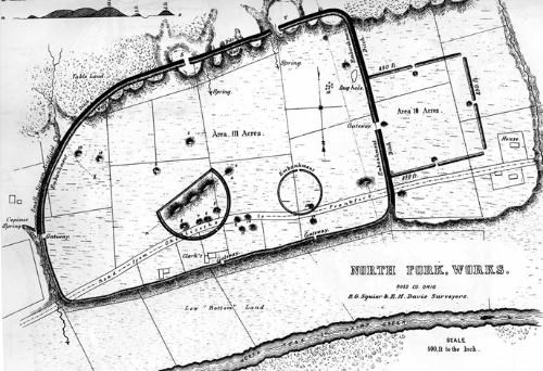
Squier & Davis, c.1848

Two thousand years ago, people of an advanced culture gathered here to conduct religious rituals and ceremonies related to their society. At this site, they built an enormous earthwork complex spanning about 130 acres. An earthen wall extended for over two miles, surrounding an immense sacred space that included 29 burial mounds. Astounding quantities of finely crafted art made of exotic materials were buried here as part of elaborate mortuary ceremonies.
The 300-acre Hopewell Mound Group is the type site for the Hopewell culture. Early archeologists named the site for its owner, Mordecai C. Hopewell. The general shape of the Hopewell Mound Group is a parallelogram 1,800 feet long on the east and the west sides and 2,800 feet long on the north and south. Archeologists estimated that the walls were originally 35 feet wide at the base and enclosed an area of 111 acres. A smaller square enclosure with sides 850 feet long is connected to the east side of the parallelogram. Remnants of the east, west, and north walls are visible. Two earthworks features are located within the parallelogram, one circular and one D-shaped. Three of the seven mounds in the D-shaped enclosure are joined. Their original size is estimated to be 500 feet long, 180 feet wide, and 30 feet tall. This is the largest known mound constructed by the Hopewell culture, and a remnant of it is visible today.
Additional Hopewell Mound Group Information
 Squier & Davis, c.1848 Two thousand years ago, people of an advanced culture gathered here to conduct religious rituals and ceremonies related to their society. At this site, they built an enormous earthwork complex spanning about 130 acres. An earthen wall extended for over two miles, surrounding an immense sacred space that included 29 burial mounds. Astounding quantities of finely crafted art made of exotic materials were buried here as part of elaborate mortuary ceremonies. This site is accessible for visitors during daylight hours. Hopewell Mound Group has a 2.5 mile interpretive trail and a portion of the Rails-To-Trails bike path. Bikes are only permitted on the bike path, not on the interpretive trail. This site contains restrooms and a covered picnic shelter. Information on visiting the site today. 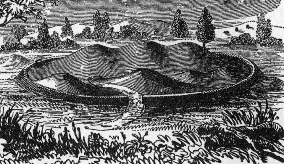 Squier & Davis 1848 New to Science The culture discovered at this site was new to the science of archeology in the late 1800’s. Newly described cultures field, which happened to be owned by a gentleman named Mordecai Hopewell at the time. Consequently, a remarkable American Indian culture, which is believed to have stretched from the Great Lakes to the Gulf of Mexico, is named after an otherwise obscure Chillicothe land owner. The true tribal names of these people were lost over the millennia, but the ancient American Indians who built this sprawling structure were part of a cultural golden age that flourished in this region from A.D. 1 to 400. The monumental architecture and artifacts of the Hopewell culture reflect a pinnacle of achievement in the fields of art, astronomy, mathematics and engineering, the likes of which was seldom seen again in eastern North America. A List of Superlatives Even when compared to all of the other astonishing prehistoric earthworks in the Chillicothe area, Hopewell Mound Group stands out in many regards. This complex included the largest single earthen-walled enclosure constructed by the Hopewell – encompassing over 110 acres. Within its walls was the largest burial mound the Hopewell people ever built: Mound 25 was 500 feet long and 33 feet high. Ephraim Squire’s dramatic 1848 engraving (seen above) pictures this enormous triple peaked mound surrounded by the low earthen wall that formed a smaller D-shaped enclosure within the great enclosure. This site provided the greatest set, both in quality and quantity, of artistic Hopewell objects ever discovered. Many of the most famous images of the Hopewell culture are from the objects found at this site: the mica bird claw the copper bear paw, and the mica hand with its elongated fingers stretching upward. The artifacts were often made of exotic materials not found in Ohio. A vast trade network appears to have thrived during this period. Huge ceremonial blades made of obsidian from Yellowstone National Park were discovered here. In fact, the total amount of obsidian here was the largest ever found east of the Mississippi River. While most Hopewell complexes seem to have been used for less than two centuries, evidence suggests that Hopewell Mound Group remained an important ceremonial center throughout the entire era of the Hopewell Culture in Ohio, a period of about four hundred years! All of these extraordinary features support the idea that Hopewell Mound Group was possibly the most important ceremonial center of all the earthworks in southern Ohio. Searching for Remnants Unfortunately, this fabulous earthwork complex fell victim to the same fate that claimed nearly all of the many renowned earthwork complexes of southern Ohio. Two centuries of plowing gradually leveled the sloping earthen embankment walls until they are barely visible today. The mounds that were too large to plow were excavated to below ground level by archeologists in the early 1900’s and never reconstructed. Sadly, the great earthen monuments of this sacred site are now all but invisible to the casual visitor’s eye. However, with some effort, the keen-eyed observer can still find signs of prehistoric grandeur here. The interpretive trail meanders past some of the site’s significant features. Paralleling the trail on the northwest side of the great enclosure, lies an intact, six-foot-high section of the original 2,000-year-old embankment wall. Use the key on the below map to locate the other visible remnants of the Hopewell Mound Group earthworks. Squier & Davis 1848 New to Science The culture discovered at this site was new to the science of archeology in the late 1800’s. Newly described cultures field, which happened to be owned by a gentleman named Mordecai Hopewell at the time. Consequently, a remarkable American Indian culture, which is believed to have stretched from the Great Lakes to the Gulf of Mexico, is named after an otherwise obscure Chillicothe land owner. The true tribal names of these people were lost over the millennia, but the ancient American Indians who built this sprawling structure were part of a cultural golden age that flourished in this region from A.D. 1 to 400. The monumental architecture and artifacts of the Hopewell culture reflect a pinnacle of achievement in the fields of art, astronomy, mathematics and engineering, the likes of which was seldom seen again in eastern North America. A List of Superlatives Even when compared to all of the other astonishing prehistoric earthworks in the Chillicothe area, Hopewell Mound Group stands out in many regards. This complex included the largest single earthen-walled enclosure constructed by the Hopewell – encompassing over 110 acres. Within its walls was the largest burial mound the Hopewell people ever built: Mound 25 was 500 feet long and 33 feet high. Ephraim Squire’s dramatic 1848 engraving (seen above) pictures this enormous triple peaked mound surrounded by the low earthen wall that formed a smaller D-shaped enclosure within the great enclosure. This site provided the greatest set, both in quality and quantity, of artistic Hopewell objects ever discovered. Many of the most famous images of the Hopewell culture are from the objects found at this site: the mica bird claw the copper bear paw, and the mica hand with its elongated fingers stretching upward. The artifacts were often made of exotic materials not found in Ohio. A vast trade network appears to have thrived during this period. Huge ceremonial blades made of obsidian from Yellowstone National Park were discovered here. In fact, the total amount of obsidian here was the largest ever found east of the Mississippi River. While most Hopewell complexes seem to have been used for less than two centuries, evidence suggests that Hopewell Mound Group remained an important ceremonial center throughout the entire era of the Hopewell Culture in Ohio, a period of about four hundred years! All of these extraordinary features support the idea that Hopewell Mound Group was possibly the most important ceremonial center of all the earthworks in southern Ohio. Searching for Remnants Unfortunately, this fabulous earthwork complex fell victim to the same fate that claimed nearly all of the many renowned earthwork complexes of southern Ohio. Two centuries of plowing gradually leveled the sloping earthen embankment walls until they are barely visible today. The mounds that were too large to plow were excavated to below ground level by archeologists in the early 1900’s and never reconstructed. Sadly, the great earthen monuments of this sacred site are now all but invisible to the casual visitor’s eye. However, with some effort, the keen-eyed observer can still find signs of prehistoric grandeur here. The interpretive trail meanders past some of the site’s significant features. Paralleling the trail on the northwest side of the great enclosure, lies an intact, six-foot-high section of the original 2,000-year-old embankment wall. Use the key on the below map to locate the other visible remnants of the Hopewell Mound Group earthworks. 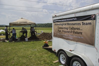 Archeological crew from Hopewell Culture NHP work under a tent at Hopewell Mound Group during the 2014 field season. NPS / Tom Engberg Archeological Expeditions When Europeans first came to this area in the late 1700’s they were amazed to find so many giant earthworks in the Chillicothe area. Eventually, word spread about the intriguing phenomenon and archeologists arrived to study the earthwork and its burials. The current theories about Hopewell Mound Group and its builders are founded on the scientific conclusions of archeologists who have studied this site over nearly two centuries.1820: Caleb Atwater draws the first map of these earthworks. Atwater assumes the site had been built for defense. He names the earthworks “Clark Fort” after the owners of the farm field. 1848: Ephraim Squier and Edwin Davis draw the most famous map of the site and include it in their groundbreaking work Ancient Monuments of the Mississippi Valley, the first book ever published by the Smithsonian Institution. They name the complex “North Fork Works,” due to its proximity to the North Fork Paint Creek. 1891-92: Warren Moorehead excavates to find artifacts for the 1893 “World’s Columbian Exposition” in Chicago. By this time, Mordecai Hopewell owns the land. Moorehead partially excavates several of the mounds, including about a quarter of the largest mound, Mound 25. The abundance and exquisite craftsmanship of the artifacts enthralls visitors at the exposition and the concept of the “Hopewell Culture” is born. After the exposition, all the artifacts are stored and displayed in Chicago’s newly created “Field Museum.” 1922-25: Henry Shetrone and William Mills of the Ohio Historical Society excavate all the mounds of what is now called “Hopewell Mound Group.” By this time, many of the mounds and the walls of the square have disappeared under the plow. None of the excavated mounds are reconstructed. Today, the discovered artifacts are stored or displayed at the Ohio Historical Center in Columbus. 1980: Archeologist Mark Seeman of Kent State University accurately relocates most of the mounds through aerial photography and surface survey. By this time, the only part of the earthworks left intact is the wall and adjacent ditch on the north side of the great enclosure. 2001: Using magnetometry, archeologists from the National Park Service and OSU find no evidence of long term settlement within the earthen walls. They also discover a new 90-foot diameter circular earthwork within the great enclosure (the smaller circle on the map between Mounds 2 and 23). Visiting the Site Park grounds are open every day during daylight hours. Facilities at Hopewell Mound Group include restrooms, a picnic shelter and a two-mile self-guided interpretive trail. The Tri-County Triangle Trail, a paved bike trail which traverses the site, runs for over thirty miles between Chillicothe and Washington Courthouse. See map below for layout of trail and parking lot access. The parking area at the trailhead is located on Sulphur Lick road, just west of Maple Grove road and the North Fork Creek. 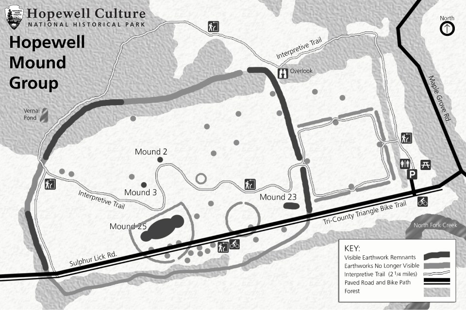 |

HOPETON GREAT CIRCLE & SUGARLOAF MOUNTAIN

“There was a wall at the Great Circle at the Hopeton site. For those of you interested in dry archeological research, here is more about an interesting and recent discovery at the Hopeton Great Circle (adjacent to the Cedar Bank site near Chillicothe OH and also adjacent to the Chillicothe Ward building). Typically, I try to remain abreast with the research happening each year in Ohio and nearby. I spoke with an archaeologist last summer [2017] at the site, and learned of his confirmation of anomalies indicated by a an extensive magnetometry survey. The other day in conversation, we discussed more details regarding the findings. It appears the Great Circle has evidences of a wooden fence, where the at least 6 ft height 1050 ft diameter earthen wall (enclosing 20 acres) was located. Indications are a pattern of very large posts spaced every 6 meters. This excavation last season revealed a post mold to be 96cm (about 38 inches) in diameter and 1.13 meters deep. One can estimate the height from that data. Indications are that smaller posts existed between the larger ones. The Hopeton site is significant in its location in relation to Cedar Bank, Sugarloaf, Mound City, and Dunlap Works and likely others. The current Chillicothe Ward building aligns with the Cedar Bank site (specifically the platform mound) and is within sight of Sugarloaf and in association with other major earthworks, including Hopeton. I am pretty sure Church engineering had not considered the earthworks when the building was designed.
Sugarloaf Mountain – “The Hopewell road from Newark points straight as an arrow to Sugarloaf Mountain, the hill directly behind the Cedar Bank site. It is also the hill which many Chillicothe earthworks align to. Additionally, the Marietta Road, another ancient thruway, points straight to Sugarloaf from Marietta. Then consider the Kanawha Trail from Charleston WV and the Scioto Trail from Portsmouth OH…yep, the same. It seems everything in southern Ohio points to Sugarloaf. And there is more. The largest concentration of Hopewell earthworks are within minutes of Sugarloaf (over 500). You can see Columbus OH from the top of the hill. It commands the valley more in presence as opposed to height.

I cannot overstate the significance of the hillscape in Chillicothe! The Creation and Creator can be read like a book. Consider how many times we read of the symbolic ‘get thee to the mountain’ in many accounts in the scriptures.

And then there is the irony of Ohio’s founding fathers choosing the same hills for inclusion of the state’s official seal (picture right) with the sun rising and dawning from the EAST, rising over a land that we know the Savior himself appeared in our time…in fact just a few years later.
You can not make this stuff up any better. I absolutely skip through life fearless of death because of my testimony of the things I have witnessed living a lifetime in this land. These were the people. Ohio was the place. But Sugarloaf is special. As I have climbed to the summit of Sugarloaf I have realized a spirit equal to that in the temple. My wife agrees of its uniqueness. It was clear to her the area of compaction at the summit. I hiked with my oldest son and he experienced strongly the feelings associated with the place. He described at as a place where one should remove his shoes.

Come to Ohio and I will guide you to the top of Sugarloaf. We will sit down on a fallen tree near an area of ancient compaction. We will look down on the Cedar Bank site and dozens of others immediately below us. And then I will ask you, “What do you feel?
Like Wayne May says, “There’s more.“ Assemble yourselves at the Ohio and see “I have kept in store a blessing such as is not known among the children of men, and it shall be poured forth upon their heads. And from thence men shall go forth into all nations.”
It is a dawning of yet another season.” Anthony George Lifelong Resident of Chillicothe, Ohio and Archaeological Researcher. Email Tony at: [email protected]
