

Discovery of Educated People in Great Cities
“…When…first commanded to testify of these things they [The Three Witness] demurred and told the Lord the people would not believe them for the book concerning which they were to bear record told of a people who were educated and refined, dwelling in large cities; whereas all that was then known of the early inhabitants of this country was the filthy, lazy, degraded and ignorant savages that were roaming over the land. The Lord told us, in reply that He would make it known to the people that the early inhabitants of this land had been just such a people as they were described in the book, and he would lead them to discover the ruins of great cities, and they should have abundant evidence of the truth of that which is written in the book…” – David Whitmer, Interview with James H. Hart (Richmond, Mo., 21 August 1883), as printed in Deseret Evening News, Salt Lake City, Utah
“THE LAMANITES. — The work of the Lord among the Lamanites must not be postponed, if we desire to retain the approval of God. Thus far we have been content simply to baptize them and let them run wild again, but this must continue no longer; the same devoted effort the same care in instructing, the same organization of priesthood must be introduced and maintained among the house of Lehi as amongst those of Israel gathered from gentile nations, As yet, God has been doing all, and we comparatively nothing. He has led many of them to us, and they have been baptized, and now we must instruct them further, and organize them into churches with proper presidencies, attach them to our stakes, organizations, etc. In one word, treat them exactly, in these respects, as we would and do treat our white brethren.” — MS, 44:733: a letter from Salt Lake City dated October 18, 1882. The Gospel Kingdom: Selections from the Writings and Discourses of John Taylor page 224
Ancient Hunting Grounds
In the earliest history of the Native American there are references all over about hunting grounds and sacred places the Natives used for defense, hunting and preparation.
“Leading directly into the heart of the central New York Iroquois heartland, the Forbidden Path stood at a strategic transportation break linking river systems ultimately flowing into Chesapeake Bay, the Great Lakes, and the Ohio Valley. (See pink dot on map below called Small Neck of Land). Small wonder, then, that the Unami Delaware warrior Squash Cutter warned Post and his party away on 17 June 1760 saying, “It is not allow’d either for you or our cousin (Teedyuscung) to travel it, & it is moreover dangerous, I myself must go it blindfolded.” Years later, a Seneca chief challenged Moravian missionary David Zeisberger’s presence on the path in 1767 asking “how comes it that you travel such an unfrequented road, which is no road of whites and on which no white man has ever come?” (Hulbert and Schwarze 1912-47 Spelling not corrected)
Of course these hunting areas (large yellow area below) or paths would have been protected above anything else. Below you will see an amazing find of one such Hunting Path discovered below Lake Huron.
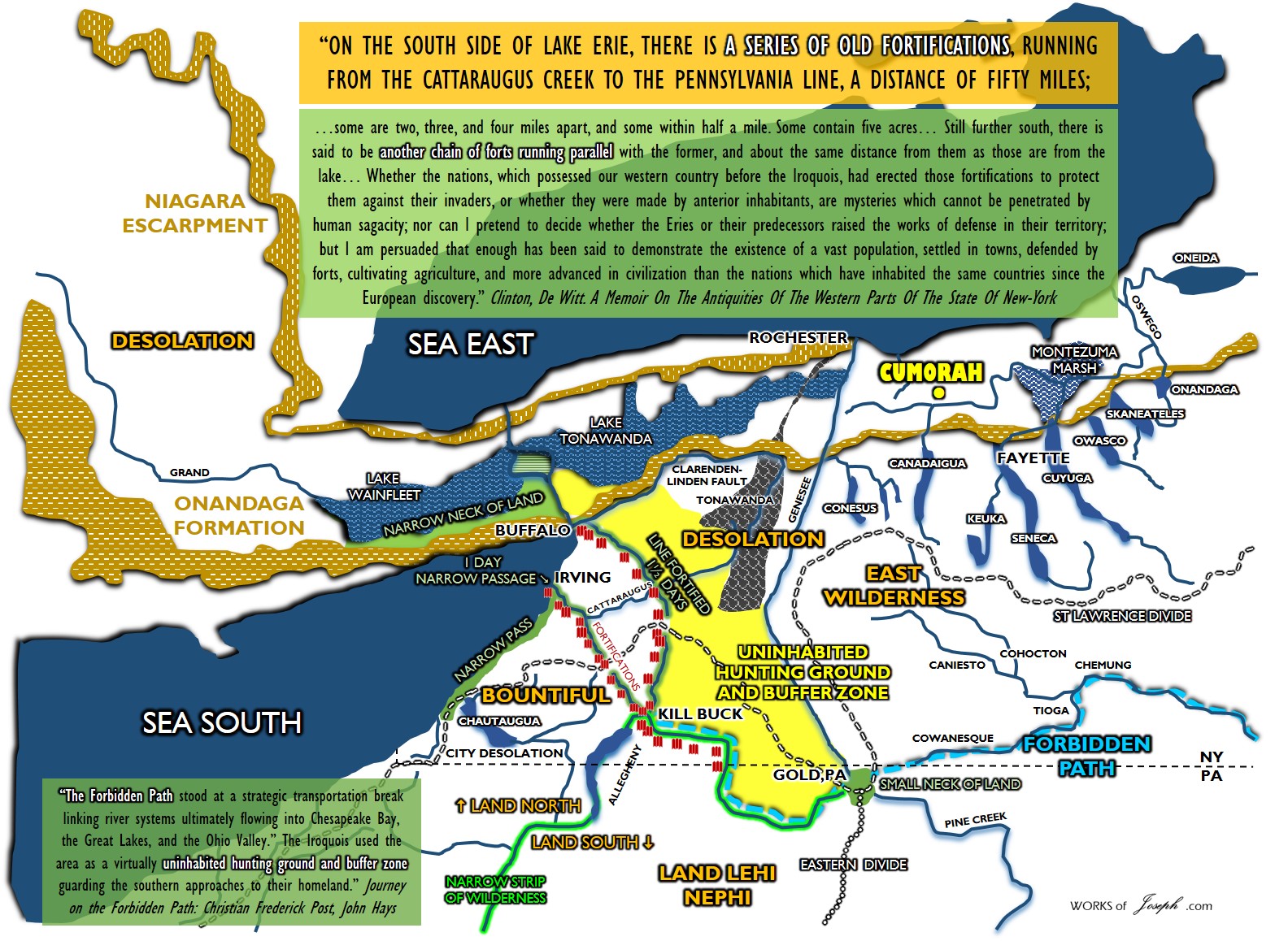
This gap above (green land with the forbidden path, [blue dotted line] running between it) these three main rivers flowing to the Atlantic, the Gulf of Mexico and the Gulf of St Lawrence, allow the Nephites or Lamanites to greatly desire this location. You can peaceably rest and hunt in these land areas, and take advantage of any river to escape or hunt etc. This “gap” (Small Neck of Land) in the rivers, would need to be defended all the time. Think of it as a gate to a fence.
“The Iroquois used the area (above in yellow) as a virtually uninhabited hunting ground and buffer zone guarding the southern approaches to their homeland. Teedyuschung, Post and their companions selected the Forbidden Path as the quickest and most direct route to the great Indian council. As described by P.A.W. Wallace (1965;46-48), the eastern terminus of the forbidden Path was located at the town of Tioga (present day Athens, PA) where the Chemung River flowed into the North Branch of the Susquehanna. The path led up the Chemung Valley past multi-cultural expatriate Indian communities at Kanawahalla (modern Elmira NY), Assinisink (Corning, NY), and Painted Post to Secaughcung at the headwaters of a tributary of the Chemung known as the Conisteo river. Passing across the height of land separation the Ohio, Great Lakes, and Susquehanna drainages, the path crossed the Genesee river and went on to pass through many Seneca and Mingo towns lining the upper Allegheny River.” Journey on the Forbidden Path: Volume 89, Part 2 By Christian Frederick Post, John Hays
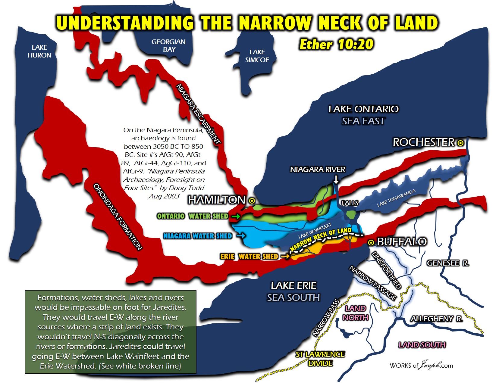
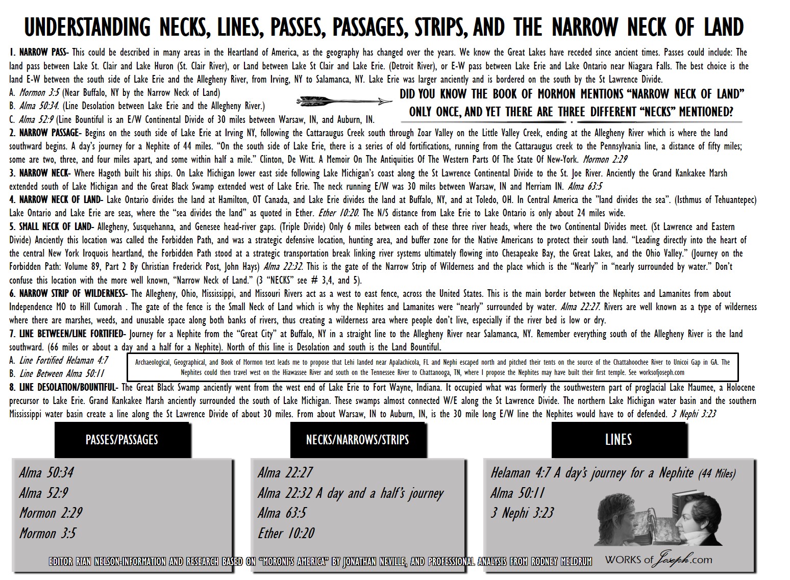
3 DIFFERENT NECKS IN THE BOOK OF MORMON
When you understand that the Narrow Neck of Land is a huge talking point of the Mesoamericanists, you will understand that they truly have the argument all backwards. THE SEA DIVIDES THE LAND, not the Land Divides the Sea.
Ether 10:20 And they built a great city by the narrow neck of land, by the place where the sea divides the land.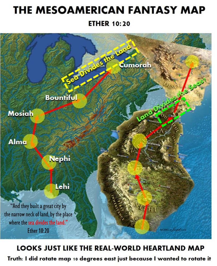
(Isthmus of Tehuantepec is LAND that DIVIDES the Sea!! Niagara Peninsula is the Sea (Ontario and Erie,) that divide the land.
They also think the 3 different NECKS we list are all the same Neck. See below.
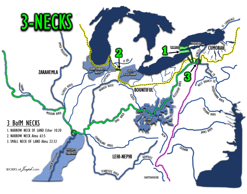
SMALL NECK OF LAND: (3 in Map Above) Allegheny, Susquehanna, and Genesee river sources or gaps (Triple Divide) Only 6 miles between each of these 3 river sources due to the two Continental Divides crossing at this point. This was an old Iroquois resting and protection point called the Forbidden Path. Alma 22:32
We believe this pink dot area is the small neck of land spoken of in Alma 22:32 “The land of Nephi and the land of Zarahemla were nearly surrounded by water, there being a small neck of land [pink area below] between the land northward and the land southward.”
This newly discovered Alpena-Amberley Ridge (yellow area on map above) helps us understand the additional geology points in possible Nephite and Jaredite lands. It seems the Great Lakes would have been much smaller and a protection of geological ridges, escarpments and bluffs, which protected the Nephites and Jaredites and were also important hunting grounds.

Amazing Find of Native Hunting Area

Lake Huron
This gorgeous bathymetric map of Lake Huron clearly shows the Alpena-Amberley Ridge (left, dotted black lines running parallel to each other), which once connected Michigan with Canada. Evidence of ancient hunting sites have been found in the now-submerged ridge. Source: MAP BY NOAA GLERL
Ancient hunting camp found beneath Lake Huron
Lake levels of the day were some 250 feet lower, exposing a narrow bridge of land running from one side of Huron to the other. Prehistoric people evidently thought this isthmus was a perfect place to intercept caribou on their seasonal migrations. The hunting site they built, now inundated, opens a window onto prehistoric America and provides valuable evidence in a region where such artifacts are practically non-existent.
If the hunting structures “were on solid ground, (they) probably would’ve been bulldozed away for a Walmart parking lot by now,” says archaeologist Alan Osborn of the University of Nebraska-Omaha and the University of Nebraska State Museum, who was not part of the discovery team. Underwater archaeology is expensive, but “in this case, it’s revealing a site that’s in pretty much pristine condition.”
Serendipity, the researcher’s friend, is to thank for this discovery as well. A half-dozen years ago, the federal government published new maps showing Lake Huron’s underwater ridge, which runs from northeastern Michigan to southern Ontario, as archaeologist John O’Shea was reading a book about Siberian reindeer herders, who laid down brush to direct their animals’ path. O’Shea, of the University of Michigan’s Museum of Anthropological Archaeology, and his colleagues decided to take a long shot and look for similar features on Huron’s underwater ridge.
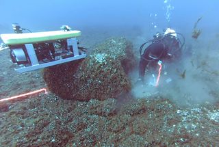
With the help of sonar, a remote-controlled underwater vehicle and scuba divers, O’Shea’s team eventually found a complicated system of submerged structures at a point where the caribou’s spring and fall migration paths would’ve crossed. In the fall, caribou heading south along the land bridge would’ve made their way straight into a simple cluster of stone hunting blinds.
But animals heading north in the spring marched into a much more systematic form of ambush. The site’s architects carefully placed two parallel lines of boulders to outline a path 26 feet wide and 100 feet long. Caribou naturally follow lines, O’Shea says, so they would’ve walked along this “drive lane” only to hit a dead end created by a natural stone wall. Meanwhile hunters could hide in another clutch of stone hunting blinds built along the lane. The ground here was littered with debris from the manufacture or repair of stone tools, probably spear points, the researchers say in this week’s issue of the Proceedings of the National Academy of Sciences.
The site speaks to the seasonal pattern of the earliest Americans’ lives, O’Shea says. People probably didn’t live on the isthmus. But in the spring, numerous families would’ve congregated at the drive lane, which required perhaps 15 or 16 hunters to operate.
“That doesn’t sound like a huge number, but if these people are living in small family groups most of the year, that’s a pretty significant aggregation,” O’Shea says. People would have socialized as well as hunted before dispersing, he says. Smaller groups would’ve gathered to use the fall hunting blinds. Other prehistoric sites — though none in the Great Lakes — boast similar innovations.
The researchers make a “compelling case,” says Leland Bement of the Oklahoma Archaeological Survey, who was not affiliated with the study team. The site, he says via e-mail, “provides another example of the skill and level of organization of big-game hunters in North America … and the ability of the hunters to plan and execute strategies to intercept these animals.” The find also shows that it’s possible to gain valuable results from underwater exploration, he says.
Such experience may come in handy as researchers try to chart the paths of the first Americans. It’s likely that archaeological sites from the time are submerged, and O’Shea says the new discovery shows the value of underwater searches.
“In the Great Lakes, there was no evidence of what (early Americans) were doing at all,” he says. “By looking in the right place we were able to find them.”
In Photos: Hunting Structure Hidden Beneath Lake Huron
Hidden from view
An elaborate array of linear stone lanes and V-shaped structures has been discovered on an underwater ridge in Lake Huron, marking what is thought to be the most complex set of ancient hunting structures ever found beneath the Great Lakes, according to a new report. (Shown here in an acoustic image of the site.)
Huron Map
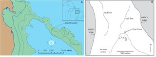
The site, called Drop 45 Drive Lane, consists of two parallel rock-lined paths that would have funneled caribou into an 26-foot-wide (8 meters) lane, with V-shaped hunting blinds perched on a hill above the lane. (Modern land is shown in brown, while areas of exposed dry land some 9,000 years ago are in green.)
Site Topography
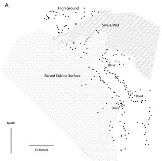
Here, a plan showing the major topographic and cultural features associated with the caribou hunting site beneath Lake Huron. (Placed stones shown with black dots; hunting blinds incorporated within the main site are labeled; and raised cobble surface to the north and west of the drive lane varies also shown.)
Light and Dark
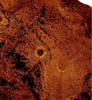
An acoustic image of the ancient caribou hunting site produced via a mosaic of scanning sonar images. (Light colored objects are stones that produce a strong acoustic signature while dark areas are acoustic shadows.)
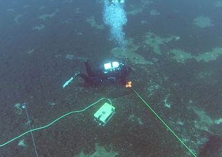
Researchers based at the University of Michigan think the roughly 9,000-year-old-structure helped natives corral caribou herds migrating across what was then an exposed land-corridor — the so-called Alpena-Amberley Ridge — connecting northeast Michigan to southern Ontario. The area is now covered by 120 feet (37 meters) of water, but at the time, was exposed due to dry conditions of the last ice age. Here, a diver and ROV taking measurements at the site.
Lake Huron
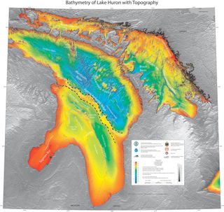
NOAA bathymetric map of Lake Huron with the Alpena-Amberley Ridge indicated by dashed lines.
Bottom of the Lake
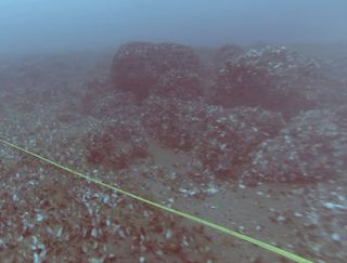
The team also found what appear to be V-shaped hunting blinds oriented both to the southeast and the northwest, and a rectangular area that may have been used as a meat cache, according to the researchers.
Ancient Hunting Blinds

The team also found what appear to be V-shaped hunting blinds oriented both to the southeast and the northwest, and a rectangular area that may have been used as a meat cache, according to the researchers
Underwater Treasure
A stacked stone hunting blind that is incorporated into the ancient caribou hunting site found beneath Lake Huron.
Moroni’s America Map Book
Here is a map from my Moroni’s America Map Book on page 17. It shows more detail of the areas above near Cumorah. For additional information about the Day and a Half for a Nephite and the Narrow Passes, etc. see my blogs below or purchase all 210 maps by clicking on the picture left.
The Only Narrow Neck of Land
Understanding Neck, Lines and Passages


