
NEW INFORMATION TO STRENGTHEN HEARTLAND GEOGRAPHY
The Plains of the Heartland! The Most Sacred Land!
WARNING: This is a long article. Only the brave need to move forward.
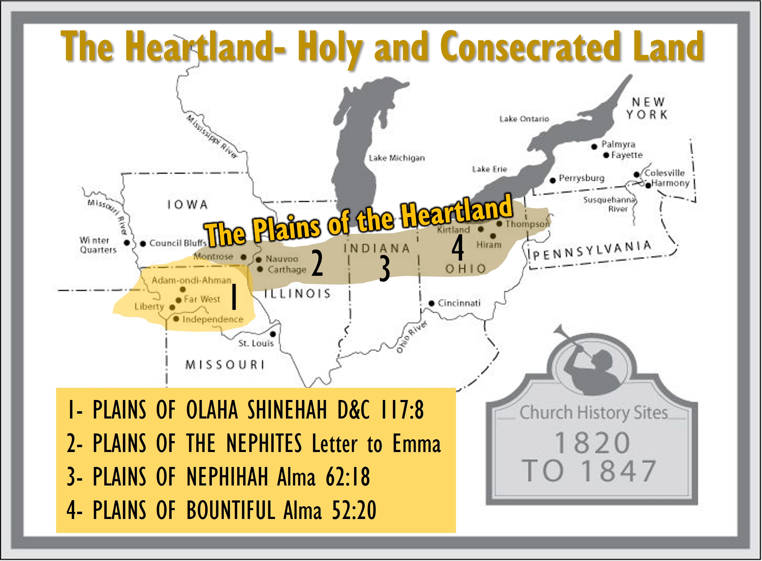
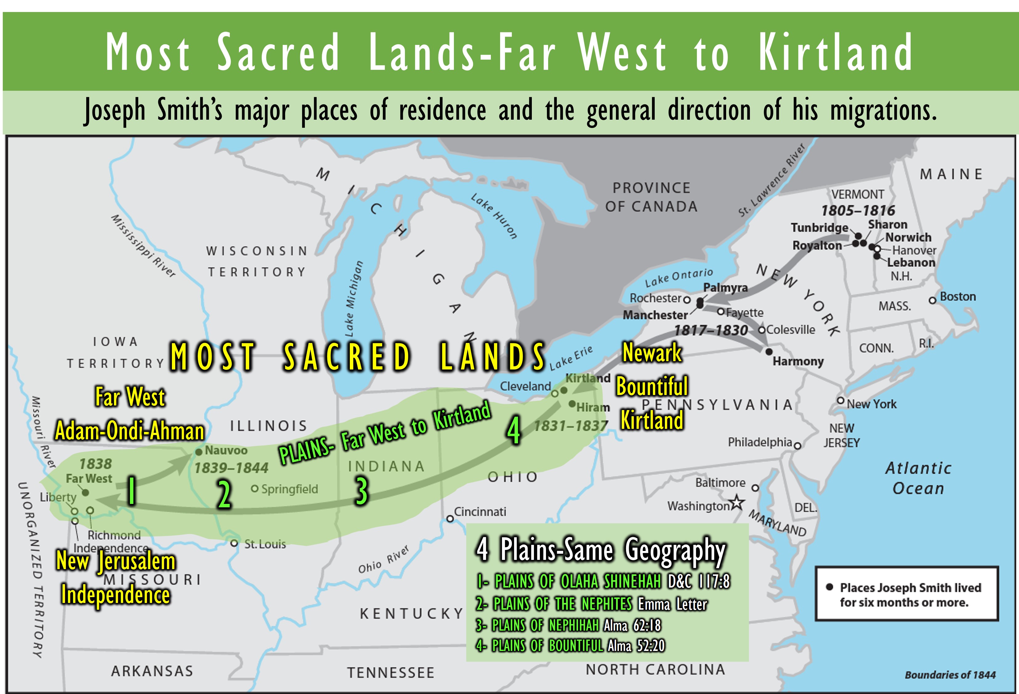
As I continue to look and research, I feel strongly that the most sacred and blessed land in the Promised Land of the United States which in my opinion should be called, “The Plains of the Heartland.” These plains are located in the United States Central Lowlands, roaming from the cradle of civilization where Adam dwelt near Independence, MO, all the way to Kirtland, Ohio, where the first Temple of the Restoration was dedicated. It spans 800 miles of sacred land I now call, “The Plains of the Heartland” (See map below)
Sacred Plains of the Nephites. Nephihah and Bountiful/Mulek
Why are the Plains of the Nephite Heartlands so sacred? It is where life began where Adam was placed on these plains, and it will end where the New Jerusalem will be built at that same location. It was on these Plains that Joseph saw in vision, and said in a letter to Emma that he was, “wandering over the plains of the Nephites, recounting occasionally the history of the Book of Mormon, roving over the mounds of that once beloved people of the Lord, picking up their skulls & their bones, as a proof of its divine authenticity…” JSP
These Plains are where Captain Moroni at age 25, takes over the Nephite armies in 74 BC and he begins his defense on the Plains of the Nephites. Moroni will also travel over the Plains of Nephihah and the Plains of Bountiful/Mulek during their defense of freedom for our blessed country.
Captain Moroni commands the Lamanites to make a covenant of peace or be destroyed. Moroni said, “I command you by all the desires which ye have for life, that ye up your weapons of war unto us, and we will seek not your blood, but we will your lives, if ye will go your way and come not again to war against us.” Alma 44:6
In about 73 BC, Captain Moroni made that sacred oath with God we are very familiar with. We read in Alma 46:22, “Now this was the covenant which they made, and they their garments at the feet of Moroni, saying: We with our God, that we shall be destroyed, even as our brethren in the land northward, if we shall fall into transgression; yea, he may cast us at the feet of our enemies, even as we have cast our garments at thy feet to be trodden under foot, if we shall fall into transgression.
Moroni said unto them: Behold, we are a of the seed of Jacob; yea, we are a remnant of the seed of , whose was rent by his brethren into many pieces; yea, and now behold, let us remember to keep the commandments of God, or our garments shall be rent by our brethren, and we be cast into prison, or be sold, or be slain.” Alma 46:22-23
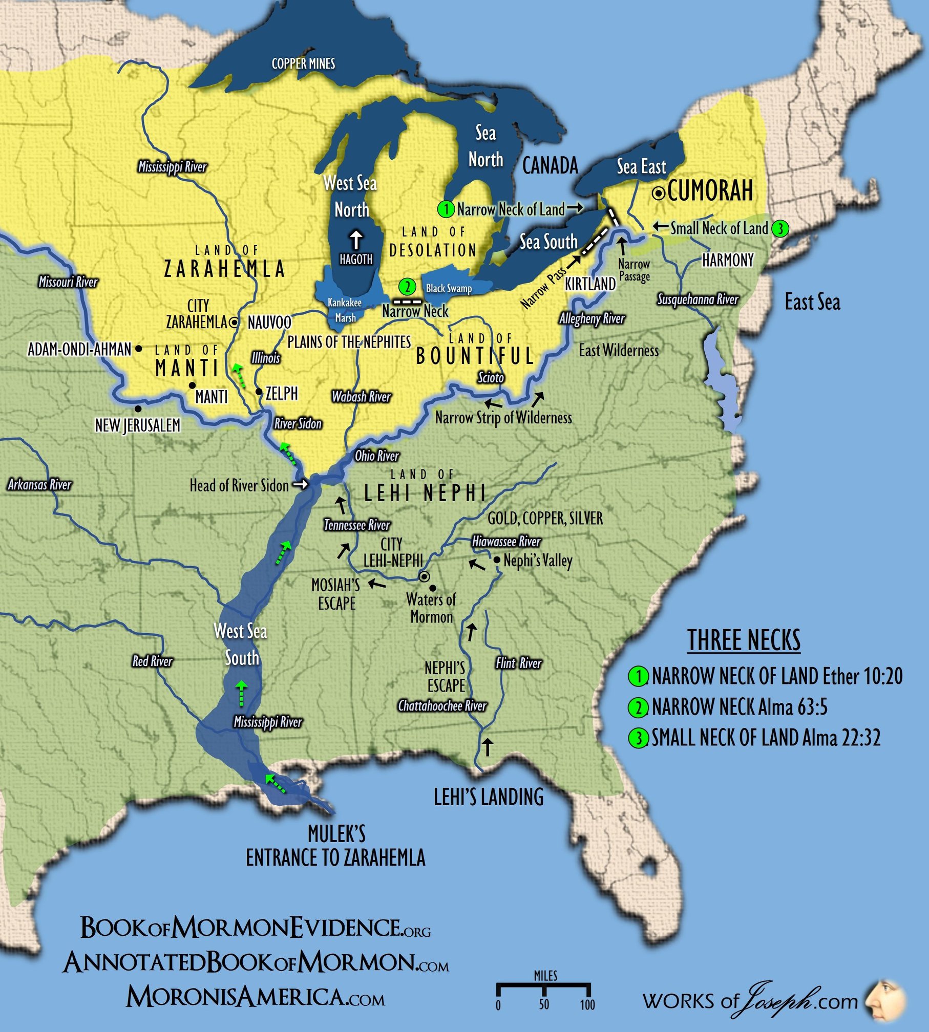
On the Plains between Mulek [Ft. Wayne Indiana?] and Bountiful [Newark, Ohio?], Captain Moroni, Teancum, and Lehi defeated Jacob and defended the City Bountiful for the Nephites in 65 BC (Alma 52:20). Therefore, Captain Moroni takes the city of Mulek by stratagem, Alma 52:21–26. See Plain #4 on map below
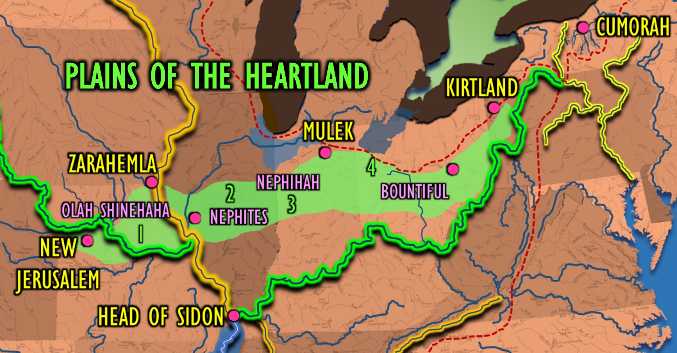
It was also on the plains of Nephihah where Pahoran and Moroni retook Nephihah in 62 BC (Alma 62:18). Then, Moroni takes the city of Nephihah, Alma 62:18–26. And, after fortifying Nephite lands, Moroni yields command of the army to his son Moronihah. Alma 62:42–43. We also see “Helaman and his brethren went forth, and did declare the word of God with much power unto the convincing of many people of their wickedness, which did cause them to repent of their sins and to be baptized unto the Lord their God.” Alma 62:45.
The blood of Captain Moroni and thousands of righteous saints was lost, on these very plains where Nephites battled for the their freedom. Sacred freedom is always worth fighting for, defending, and even sacrificing our very life.
Far West a Holy Consecrated Place
“To his steady drum roll about the Indian and his destiny, [WW] Phelps added his view of the land west of the Missouri settlements, which he called the “Far West.” Wasn’t this, the editor wondered, the land of the covenant, where the Book of Mormon Jaredites and Nephites had once roamed before meeting their destruction? While the world would never prize the area because of its want of timber and mill seats, Deity had a different view.
This land was Zion, he argued, the land of Joseph, the receptacle of “the chief things of the ancient mountains, and for the precious things of the lasting hills.” In a few sentences, Phelps wove together some of the images that Joseph Smith had been using when speaking of the western Zion and the soon-to-be redeemed Indian 47” (47 Evening and the Morning Star 1 (October 1832): 137] Phelps was citing Deuteronomy 3313-17 The editor later would help select Mormon settlement sites in Daviess County and may have had a role in choosing the name of the region’s most prominent town, Far West, thus giving another expression to his fascination with the western region).” SEEKING THE “REMNANT”: THE NATIVE AMERICAN DURING THE JOSEPH SMITH PERIOD Ronald W Walker
Nephitish Altar
George W. Robinson, a scribe of Joseph Smith who was with him at the time, writes: “We next kept [traveling] up the river mostly in the timber for ten miles, until we came to Colonel Lyman Wright’s who lives at the foot of Tower Hill. A name appropriated by President Smith in consequence of the remains of an old Nephitish Altar and Tower where we camped for the Sabbath.” (Scott H. Faulring ed., An American Prophet’s Record: The Diaries and Journals of Joseph Smith, SLC: Signature Books, 1989, p. 184.) 1838 Joseph Smith, Jr. History of the Church of Jesus Christ of Latter-day Saints, 3:34-35 Quoted in Step by Step through the Book of Mormon by Alan C. Miner
So what did Robinson mean when he said they discovered the remains of a “Nephtish” structure? It is important to note that the early Latter-day Saints clearly believed that the native North American tribes were descendants of the earlier Nephite-Lamanite civilization. With this belief, Robinson probably used the word “Nephitish” to indicate that the structure or altar was built by, or originated with, the North American Indians. He may have also used “Nephitish” to mean that the altar was of ancient origin. Therefore, what Robinson was attempting to describe were the remains of what appeared to be a sacred altar structure erected by early Native Americans.” (Alexander L. Baugh, “Joseph Smith in Northern Missouri,” in Joseph Smith, the Prophet and Seer, ed. Richard Neitzel Holzapfel and Kent P. Jackson (Provo, UT: Religious Studies Center, Brigham Young University; Salt Lake City: Deseret Book, 2010), 291–346.)
The Spot where Cain killed Abel.
“In connection with President McKay’s visit at Far West, it is to be noted that while there the President appeared somewhat overwhelmed. The place made a deep impression upon him; so much so that he referred to Far West a number of times in the ensuing days as a place of deep impression.
“The feeling that President McKay had at Far West registered upon me once again, but now with greater impact. The events that transpired there are significant: (a) The Lord proclaimed Far West a holy and consecrated land unto him, declaring to Joseph Smith that the very ground he stood on there was holy. (b) The Prophet Joseph Smith contended with the devil face to face for some time, upon the occasion of the power of evil menacing one of his children in the Prophet’s home just west of the temple site. Lucifer declared that Joseph had no right to be there, that this was his place. Whereupon the Prophet rebuked Satan in the name of the Lord, and he departed and did not touch the child again. (c) The overwhelming feeling that President McKay had when he visited this sacred place.
“The Answer: I have often pondered the holy significance of Far West, and even more so since President McKay’s visit. The sacredness of Far West, Missouri, is no doubt due to the understanding that the Prophet Joseph Smith conveyed to the brethren, at these early times, that Adam-ondi-Ahman, the place to which Adam and Eve fled when cast out of the Garden of Eden, is where Adam erected an altar unto God, and offered sacrifices, and that Far West was the spot where Cain killed Abel.
“This information tends to explain why the Lord declared Far West to be a holy consecrated place; and no doubt explains why Satan claimed that place as his own, as it was here that he entered into a covenant with Cain, resulting in the death of Abel, the first of mortal existence [to die] upon this earth.
“It would appear that President McKay while there felt the spirit and significance of this holy place.” The Life of Joseph Fielding Smith, p.340
Holy Kirtland Temple
With Willard Richards acting as scribe, Joseph Smith gave a revelation on Aug. 2, 1833, “And again, verily I say unto you, my friends, a commandment I give unto you, that ye shall commence a work of laying out and preparing a beginning and foundation of the city of the stake of Zion, here in the land of Kirtland, beginning at my house…
On March 27, 1836, Joseph Smith gave the dedicatory prayer for the temple, which he said was given to him by revelation. This dedicatory prayer is now found in D&C 109.” Source
“The Bible tells us that the original followers of Jesus, known as ‘saints,’ gathered at the Temple in Jerusalem; the Latter Day Saints mirrored their experience by building the Kirtland Temple where they, too, could tarry until they were endowed or clothed with the Holy Spirit (Luke 24:49). They felt this endowment was necessary so they could then go forth into the world filled with the Spirit to share the message of Jesus Christ.” Source
Elder Alvin R. Dyer, whom President McKay subsequently ordained an apostle and later set apart as a counselor in the church presidency, offered some interesting after-thoughts on Far West:
Plains of Olaha Shinehah/Adam-ondi-Ahman
“The editor [Bruce R. McConkie] later would help select Mormon settlement sites in Daviess County and may have had a role in choosing the name of the region’s most prominent town, Far West, thus giving another expression to his fascination with the western region. “Certain lands were given to Israel for an inheritance in time and in eternity. America is the land of Joseph; it was the home of Nephite Israel, who were of Joseph, for a thousand years, and it is the headquarters of the Church in this final dispensation in which the church and kingdom of God are in the hands of Ephraim.” (McConkie, Bruce R., A New Witness for the Articles of Faith [1985], 511.)
But one of the most sacred events that happened on the Plains of Olaha Shinehah was, three years before his death, Adam gathered his righteous posterity in Adam-ondi-Ahman and blessed them, “and the Lord appeared unto them” (see D&C 107:53–56). Before the Millennium, another important meeting will occur in Adam-ondi-Ahman, during which the Savior and Adam and other prophets will gather with righteous Church members (see D&C 27:5–14; Daniel 7:13–14, 22). Here we learn the Plains of Olaha Shinehah or the “place where Adam dwelt” is one of the most Holy sites in the history of this Earth. All of this happened or will happen on the “Plains of the Heartland”.
Proof of its Divine Authenticity/Zelph
Zelph’s skeleton was found near Valley City, Illinois by Zion’s camp members in 1834 and in vision Joseph called his name Zelph and his great prophet was named Onandagus, and the mound referred in history is Naples Russell Mound 8. It is upon the “Plains of Nephi”
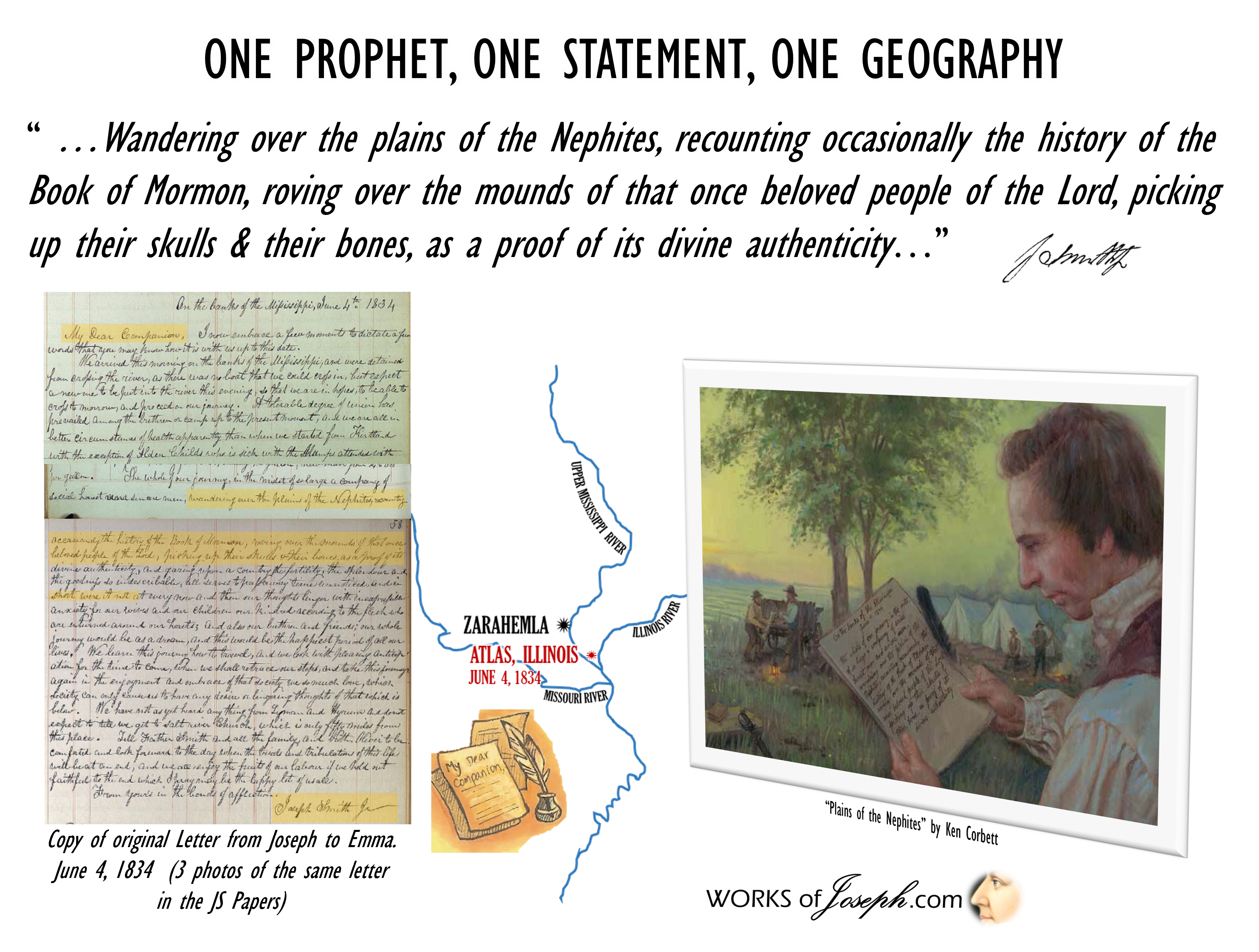
“The whole of our journey, in the midst of so large a company of social honest and sincere men, wandering over the plains of the Nephites, recounting occasionally the history of the Book of Mormon, roving over the mounds of that once beloved people of the Lord, picking up their skulls & their bones, as a proof of its divine authenticity… During our travels we visited several of the mounds which had been thrown up by the ancient inhabitants of this country-Nephites, Lamanites, etc.” Joseph Smith Papers Letter to Emma Smith, 4 June 1834 Page 56
“Before breaking camp the morning of June 3, the Prophet Joseph Smith, accompanied by several of the men, went to observe a large mound which was located approximately one mile below the Phillip’s Ferry crossing. It was of unusual size and lay within the proximity of a number of smaller mounds. Heber C. Kimball and Wilford Woodruff recorded in their journals that the mound was one hundred feet high and three hundred feet above the level of the river. The height of the mound enabled the men to look over the tops of the trees and view the surrounding area. At the crest of the mound, human bones were strewn around the base of what appeared to be a three-tiered altar. Heber C. Kimball wrote that the arrangement of the stones resembled the ancient order or altars..
The men were curious about the area, the mounds, and particularly about the scattered bones. As they began to descend the mound, Joseph Smith suddenly stopped, pointed to the ground, and said, “Brethren, dig in there.” When the earth had been removed to the depth of one or two feet, the men found the skeleton of a large man. Journal accounts state that, “the bones were all there and in a good state of preservation.” Buried in the backbone, between the ribs of the man was a stone arrowhead which Milton Holmes took. Examining the skeleton more closely, it was noted that one of the thigh bones had been previously broken and knitted together. The thigh bones and the arrowhead were taken back to camp and placed in Wilford Woodruff’s wagon. The skeleton was unusually large . It was estimated to be over eight feet tall.” James L. Bradley, Zion’s Camp 1834: Prelude to the Civil War (Salt Lake City: Publishers Press, 1990), p. 207.
“On the top of the mound were stones which presented the appearance of three altars having been erected one above the other, according to the ancient order; and the remains of bones were strewn over the surface of the ground. The brethren procured a shovel and a hoe, and removing the earth to the depth of about one foot, discovered the skeleton of a man, almost entire, and between his ribs the stone point of a Lamanitish arrow, which evidently produced his death. Elder Burr Riggs retained the arrow.
The contemplation of the scenery around us produced peculiar sensations in our bosoms; and subsequently the visions of the past being opened to my understanding by the Spirit of the Almighty, I discovered that the person whose skeleton was before us was a white Lamanite, a large, thick-set man, and a man of God. His name was Zelph. He was a warrior and chieftain under the great prophet Onandagus, who was known from the Hill Cumorah, or eastern sea to the Rocky mountains. The curse was taken from Zelph, or, at least, in part-one of his thigh bones was broken by a stone flung from a sling, while in battle, years before his death. He was killed in battle by the arrow found among his ribs, during the last great struggle of the Lamanites and Nephites.” Joseph Smith Papers History, 1838–1856, volume A-1 [23 December 1805–30 August 1834], Page 483
President Wilford Woodruff warned: “I will here say that God has inspired me to keep a Journal History of this Church, and I warn the future Historians to give Credence to my History of this Church and Kingdom; for my Testimony is true, and the truth of its record will be manifest in the world to Come.” (Journal of Wilford Woodruff, 6 July 1877, Historical Department, The Church of Jesus Christ of Latter-day Saints; emphasis added. Spelling and punctuation have been standardized.) The Mantle Is Far, Far Greater Than the Intellect Elder Boyd K. Packer
Manti in the Book of Mormon/Huntsville, MO
Joseph Smith accompanied several Church members in exploring the area around Lyman Wight’s northern Missouri home. In his journal, A. Jenson wrote: “The [Kirtland] camp passed through Huntsville, in Randolph County, which has been appointed as one of the stakes of Zion, and is the ancient site of the City of Manti.” A. Jenson, Historical Record, Book 1, p. 601 Millennial Star 16:296

Inverted Parallels & Chiasmus on the Plains of the Heartland

Chiasmus: (Latin term from Greek χίασμα, “crossing” and from the Greek χιάζω, chiázō, “to shape like the letter Χ”) is the figure of speech in which two or more clauses are related to each other through a reversal of structures in order to make a larger point; that is, the clauses display inverted parallelism. Chiasmus was particularly popular in the literature of the ancient world, including Hebrew, Greek, and Latin, where it was used to articulate the balance of order within the text. The elements of simple chiasmus are often labeled in the form A B B’ A’, where the letters correspond to grammar, words, or meaning. (https://en.wikipedia.org/wiki/Chiasmus)
See my blog here for more about Chiasmus
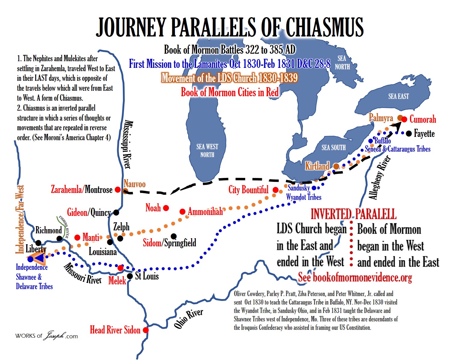
From New Jerusalem to the 100 BC Earthworks of Newark, Ohio, are these same “Plains of the Heartland.” From Joseph’s letter to Emma in Atlas, Illinois to where Emma was residing on that date of June 4, 1834 in Kirtland, Ohio, these are also “Plains of the Heartland.” If fact it seems these Plains were traveled so often by so many, it has been a clear route within the heartland geography.
Many Travels on the Plains of the Heartland
West to East
Garden of Eden to Hill Cumorah
New Jerusalem to Ontario New York
Adam-Ondi-Ahman to Kirtland Ohio
Zarahemla (Mormon/s Final Battles) to Cumorah
From Liberty MO to Kirtland Ohio
Zarahemla to Nephite Battles in MO, IL, IN, OH, PA, to NY
East to West
Cumorah (Young Mormon’s Journey) to Zarahemla (Montrose Iowa) (Mormon 1:6)
Kirtland, OH (LDS Church Migration) to Fishing River, MO Kirtland Camp to Missouri 1838
Atlas, Illinois (Emma’s Letter) to Kirtland Ohio
Zion’s Camp Kirtland to Missouri
Can there be any Doubt. Nephites in the Heartland of America?
“We see through the light of revelation that the wicked of this nation will someday be destroyed in that very area, [Cumorah] repeating the same pattern over and over again. The Nephites were destroyed there. The Jaredites were destroyed there. Will our nation go to Mexico to be destroyed at Cumorah? Of course not. Can there be any doubt that these lakes referred to are the Great Lakes? Brigham Young said: This book, which contained these things, was hid in the earth by Moroni, in a hill called by him, Cumorah, which hill is now in the state of New York, near the village of Palmyra, in Ontario County.” Cheesman, Paul R., 1978, The World of the Book of Mormon, Horizon Publishers, Bountiful, Utah, p. 24
Where did the Nephites specifically Live?
Jungles of Mesoamerica, or the Plains of the United States? Did they live on the Promised Land of America, or on a land somewhere else that may be nice, but wasn’t chosen as the Promised Land? “The United States is the promised land foretold in the Book of Mormon—a place where divine guidance directed inspired men to create the conditions necessary for the Restoration of the gospel of Jesus Christ.” Elder L. Tom Perry Ensign Dec. 2012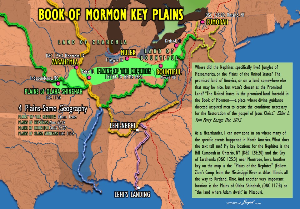
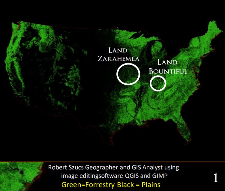
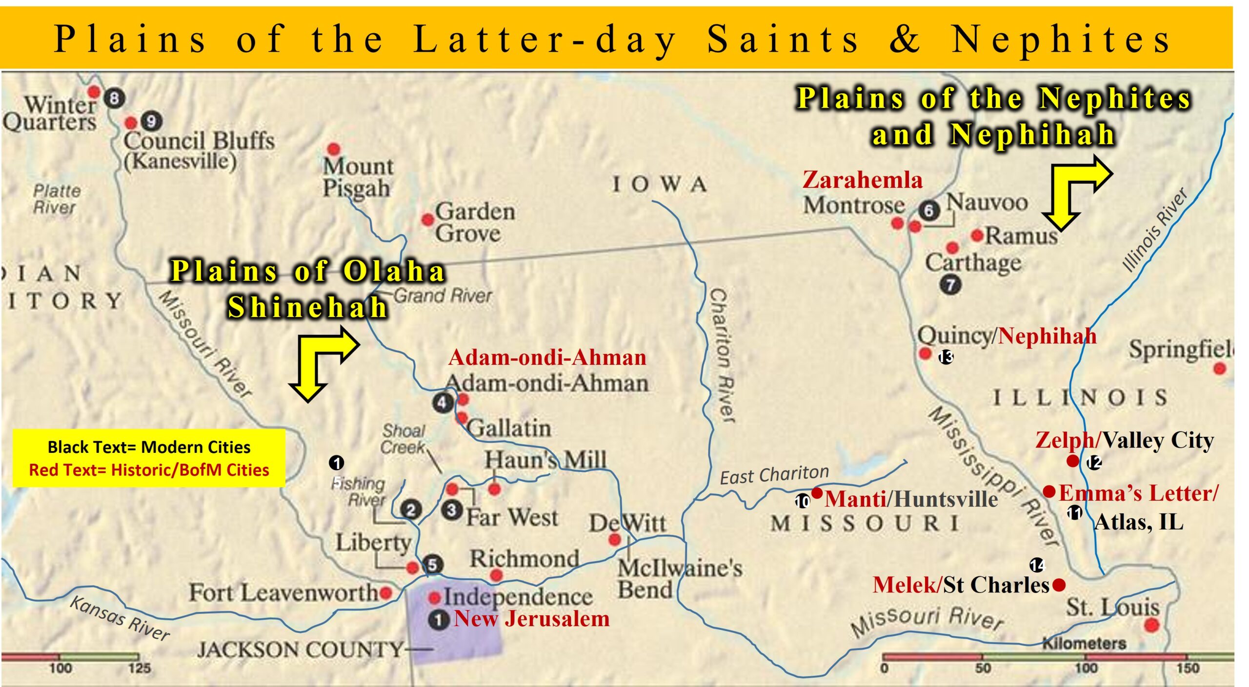
Heartland Key Locations
As a Heartlander, I can now zone in on where many of the specific events happened in North America. What does the Book of Mormon text tell me? My key locations for the Nephites is the Hill Cumorah in Ontario, NY(D&C 128:20) and the City of Zarahemla (D&C 125:3) near Montrose, Iowa. Another very critical key location on the map is the “Plains of the Nephites” (Follow Zion’s Camp from the Mississippi River at Atlas Illinois all the way to Kirtland, Ohio. See bright green plains above).
Now I add two more key locations of the Nephites. The Plains of Nephihah, and the plains of Olaha Shinehah, are these two more important key locations which I discuss today in this blog.
Very New Information (April 2024)
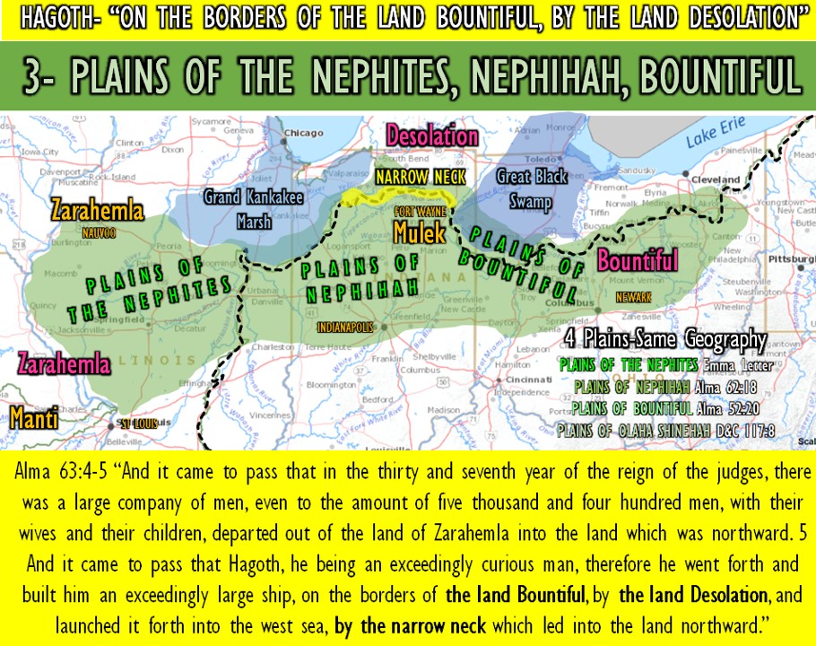
Let’s tie together, these 4-Plains of the Heartland:
1- PLAINS OF OLAHA SHINEHAH, D&C 117:8 Independence & Adam-Ondi-Ahman, MO
2- PLAINS OF THE NEPHITES Emma’s Letter[JSP] Atlas, IL to Kirtland OH
3- PLAINS OF NEPHIHAH Alma 62:18 Springfield, IL to Indianapolis, IN
4- PLAINS OF BOUNTIFUL Alma 52:20 Fort Wayne, IN to Newark, OH
Where would the Nephites have lived, and why, and what archaeology may validate it? What would be the best places of defense or where to build a fort? How important to have high places where you could see your enemy? What method of transportation would be best, walking or canoe? Where to build a city and live for long periods of time because of the nearby agricultural land or type of soil? What long term trading paths existed to share goods from all over the United States? ” Would they fight in the Jungles of Mesoamerican or on the “Plains” of the United States? I’m excited to share NEW information about my discovery of the important “Plains found between two Book of Mormon cities“, in Alma 52:20 and also the show you the importance of D&C 117:8 with the “Plains of Olaha Shinehah
New Geography about the Plains of Nephihah
In this blog I discuss a very amazing discovery. I may have found where the “Plains of Nephihah”(Alma 62:18), are located in the USA, where the “Plains between the two cities”, are located in the USA (Alma 52:20), are located, and I will tie them into what we all know about, where the “Plains of the Nephites” are located that Joseph Smith identified.
“Two named Plains of the Book of Mormon and one from Joseph, and one from Adam, and they all four are in the same general location of successive plains. Between the City Bountiful (Newark, Ohio) and the city of Mulek (Fort Wayne, Indiana). I call these the “Plains of Bountiful” or the Plains of Mulek.” Read on and explore with me.

Alma 52:9,11-13, 21-22, 26-27, 31 About Nephihah
9 And he also sent orders unto him that he should fortify the land Bountiful, and secure the narrow pass which led into the land northward, lest the Lamanites should obtain that point and should have power to harass them on every side.
11 And he also said unto him, I would come unto you, but behold, the Lamanites are upon us in the borders of the land by the west sea; and behold, I go against them, therefore I cannot come unto you.
12 Now, the king (Ammoron) had departed out of the land of Zarahemla, and had made known unto the queen concerning the death of his brother, and had gathered together a large number of men, and had marched forth against the Nephites on the borders by the west sea.
13 And thus he was endeavoring to harass the Nephites, and to draw away a part of their forces to that part of the land, while he had commanded those whom he had left to possess the cities which he had taken, that they should also harass the Nephites on the borders by the east sea, and should take possession of their lands as much as it was in their power, according to the power of their armies.”
20 And it came to pass they sent embassies to the army of the Lamanites, which protected the city of Mulek, to their leader, whose name was Jacob, desiring him that he would come out with his armies to meet them upon the plains between the two cities. But behold, Jacob, who was a Zoramite, would not come out with his army to meet them upon the plains.
21 And it came to pass that Moroni, having no hopes of meeting them upon fair grounds, therefore, he resolved upon a plan that he might decoy the Lamanites out of their strongholds.
22 Therefore he caused that Teancum should take a small number of men and march down near the seashore; and Moroni and his army, by night, marched in the wilderness, on the west of the city Mulek; and thus, on the morrow, when the guards of the Lamanites had discovered Teancum, they ran and told it unto Jacob, their leader.
26 And thus Moroni had obtained possession of the city Mulek with a part of his army, while he marched with the remainder to meet the Lamanites when they should return from the pursuit of Teancum.
27 And it came to pass that the Lamanites did pursue Teancum until they came near the city Bountiful, and then they were met by Lehi and a small army, which had been left to protect the city Bountiful.
31 And it came to pass that before the Lamanites had retreated far they were surrounded by the Nephites, by the men of Moroni on one hand, and the men of Lehi on the other, all of whom were fresh and full of strength; but the Lamanites were wearied because of their long march.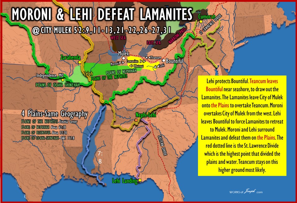
Summary of Alma 52
Lehi protects Bountiful. Teancum leaves Bountiful near seashore, to draw out the Lamanites. The Lamanites leave City of Mulek onto the Plains to overtake Teancum. Moroni overtakes City of Mulek from the west. Lehi leaves Bountiful to force Lamanites to retreat to Mulek. Moroni and Lehi surround Lamanites and defeat them on the Plains. The black dotted line is the St. Lawrence Divide which is the highest point that divides the plains. On this Divide, rain that falls on the divide will run either north or south when forming two opposite direction rivers.
Teancum stays on this higher ground most likely. This is also one of “three necks” spoken of as separate places in the Book of Mormon. This neck is called “The Narrow Neck” Alma 63:5, where later Hagoth sails his ships up Lake Michigan. See yellow on map below.
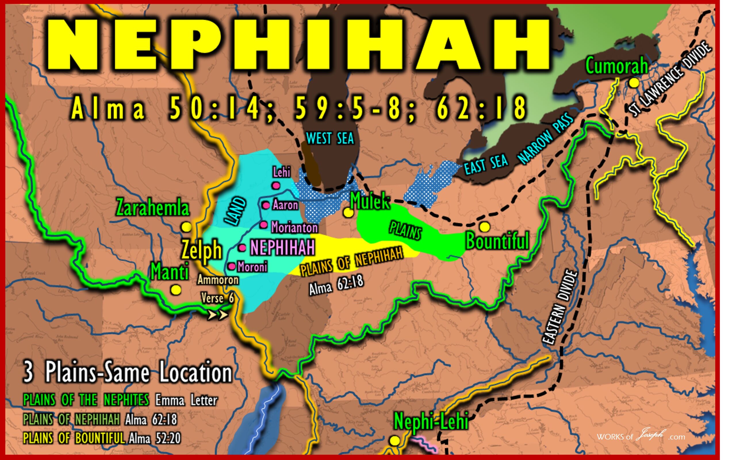
Plains Between Mulek and Bountiful
Mulek. Occupied by Jacob and the Lamanites Bountiful. Occupied by Teancum and Lehi Land Bountiful west wilderness of Mulek, Moroni was stationed.
In Alma 52:20 we read, “And it came to pass they sent embassies to the army of the Lamanites, which protected the city of Mulek, to their leader, whose name was Jacob, desiring him that he would come out with his armies to meet them upon the plains between the two cities.” What two cities? Three verses earlier in Alma 17, you will read the names of these two cities. Alma 52:17 “And it came to pass that Teancum made preparations to make an attack upon the city of Mulek [Ft. Wayne Indiana?], and march forth with his army against the Lamanites; but he saw that it was impossible that he could overpower them while they were in their fortifications; therefore he abandoned his designs and returned again to the city Bountiful [Newark, Ohio?], to wait for the coming of Moroni, that he might receive strength to his army.
Evaluating the Research
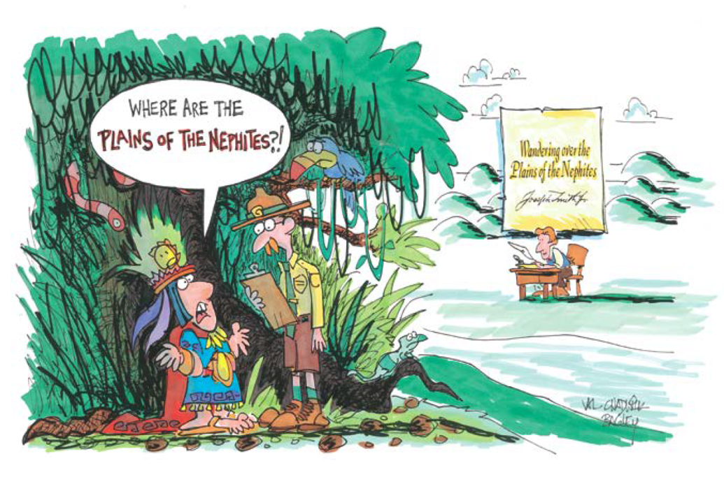
I was reading and researching last week and came upon something I thought was very significant. I was reading the wonderful quote of Joseph Smith while on Zion’s Camp march, in a letter to his wife Emma, that says, “Wandering over the Plains of the Nephites.” Joseph wrote this letter on the Banks of the Mississippi River near Atlas, Illinois.
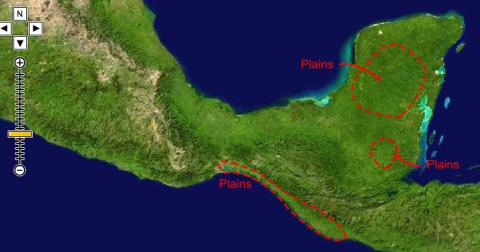
I began researching to see what other Geography theorists said about the word, “plains“, and how did they define it? I came across a site called, Book of Mormon Info, by Aric Turner. They believe in a Mesoamerican Geography. They had some good information about “plains” here, although they spoke about the Mesoamerican setting as you see in their map left. I have used some of their information and made it relate to the Heartland Geography. I learned from them in Alma 52:20 that said, “he would come out with his armies to meet them upon the plains, between the two cities.” This could be called the “plains” between Mulek and Bountiful.”
Understanding that in my Heartland Model, I feel strongly the “Plains” refer to North America and not Mesoamerica. I think of the Great Plains of the United States and I only think of Jungles in Mesoamerica. I discuss and evaluate that later.
These plains in Alma 52:20 that are quoted above, I never remembered hearing about them before, which opened up this research. I thought, how could two men come out with their armies upon the “plains” if there were a bunch of trees, jungle and shrubs around? They couldn’t. So, I believe I have found another plausible witness that the word “plains” as mentioned in the Book of Mormon follows the Heartland definition of grasslands or prairies, which validates my belief that the geography of the Book of Mormon was in the Heartland of the United States. (I encourage you to read the other theorists websites, as you may lean many other interesting things).
In another blog titled, “BofM- Jungles of Mayans or Plains of Nephites”, I ask the question again, how can the cities of Nephites in North America be hidden in plain sight, as many people have said? Yes in plain sight, just not to me and millions of others.
The Word “Plains”
This blog will explain to you about the word “Plains” found in the Book of Mormon record. In the Triple Combination Study Help it gives these “Plains” references:
Plains
Additional “Plains” in the Book of Mormon
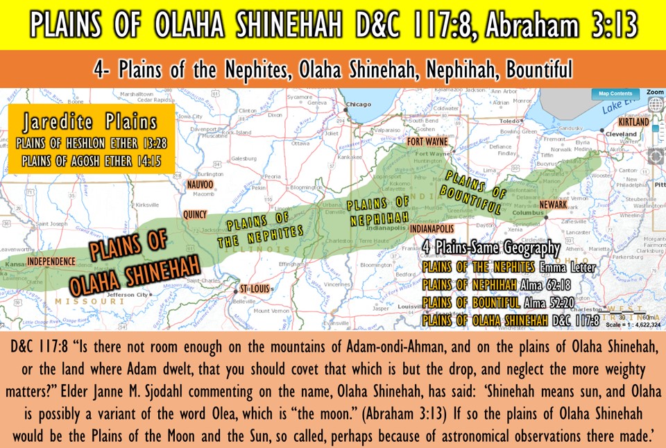
D&C 117:8 “Is there not room enough on the mountains of , and on the plains of Olaha , or the land where dwelt, that you should covet that which is but the drop, and neglect the more weighty matters?”
What did the Lord tell us about “property” in verses 5–8? (The phrase “the plains of Olaha Shinehah” refers to the land surrounding Adam-ondi-Ahman.)
Read the section heading for Doctrine and Covenants 116 and Doctrine and Covenants 116:1. What is the name of the place the Prophet Joseph Smith explored? Spring Hill, Missouri! What did the Lord reveal about Spring Hill, Missouri?
Three years before his death, Adam gathered his righteous posterity in Adam-ondi-Ahman and blessed them, “and the Lord appeared unto them” (see D&C 107:53–56). Before the Millennium, another important meeting will occur in Adam-ondi-Ahman, during which the Savior and Adam and other prophets will gather with righteous Church members (see D&C 27:5–14; Daniel 7:13–14, 22). Here we learn the Plains of Olaha Shinehah or the “place where Adam dwelt” is one of the most Holy sites in the history of this Earth. This is why knowing more about the Plains of Olaha Shinehah, and knowing more about it, is so critical to our understanding of the Gospel.
Key and Sacred Heartland Geography
By understanding that the Plains of Olaha Shinehah, the Plains of the Nephites, the Plains of Nephihah, and the Plains of Bountiful, are all a critical part of the land and geography about the Book of Mormon. The location of these “plains” show there is little doubt about the Book of Mormon events happening in this blessed Heartland of the United States.
Where are the Plains of Olaha Shinehah?
“The plains of Olaha Shinehah, or the place where Adam dwelt,” wrote President Joseph Fielding Smith, “must be a part of, or in the vicinity of Adam-ondi-Ahman.
This name Olaha Shinehah, may be, and in all probability is, from the language of Adam. We may without great controversy believe that this is the name which Adam gave to this place, at least we may venture this as a probable guess. Shinehah, according to the Book of Abraham, is the name given to the sun. (Abraham 3:13.) It is the name applied to Kirtland when the Lord desired in a revelation to hide its identity. (Sec. 82.) Elder Janne M. Sjodahl commenting on the name, Olaha Shinehah, has said: ‘Shinehah means sun, and Olaha is possibly a variant of the word Olea, which is “the moon.” (Abraham 3:13.) If so the plains of Olaha Shinehah would be the Plains of the Moon and the Sun, so called, perhaps because of astronomical observations there made.’ We learn from the writings of Moses that the Lord revealed to the ancients great knowledge concerning the stars, and Abraham by revelations and through the Urim and Thummim received wonderful information concerning the heavens and the governing planets, or stars. It was also revealed by the Prophet Joseph Smith that Methuselah was acquainted with the stars as were others of the antediluvian prophets including Adam. So it may be reasonable that here in this valley important information was made known anciently in relation to the stars of our universe.” (Church History and Modern Revelation, 2:97–98.) D&C 117:8 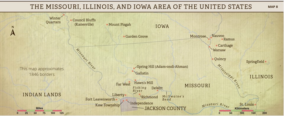
Doctrine and Covenants 117
The Lord commands William Marks and Newel K. Whitney to leave Kirtland, Ohio, and directs Oliver Granger to settle the First Presidency’s business affairs
Explain that after the Prophet Joseph Smith left Kirtland, Ohio, in January 1838, William Marks was appointed to oversee the Church in Kirtland and to settle Joseph Smith’s and Sidney Rigdon’s debts there. Bishop Newel K. Whitney was in charge of the Church’s businesses and property in Kirtland. These two men were to settle Church affairs in Kirtland and then promptly move with the rest of the Saints to Missouri. However, by July 1838, both men remained in Kirtland. (See The Joseph Smith Papers, Documents, Volume 6: February 1838–August 1839, 191.)
https://www.josephsmithpapers.org/place/olah-shinehah
Manti/Huntsville, MO
ANCIENT CITY OF MANTI IN MISSOURI.
The following account is taken from the history of the travels of the Kirtland Camp: “The camp passed through Huntsville, in Randolph County, which has been appointed as one of the stakes of Zion, and is the ancient site of the City of Manti, and pitched tents at Dark Creek, Salt Licks, seventeen miles. It was reported to the camp that one hundred and ten men had volunteered from Randolph and gone to Far West to settle difficulties.” 1
The following account of the same event is taken from the daily journal of the Kirtland Camp, and was written by Samuel D. Tyler: “September 25, 1838. We passed through Huntsville, Co, seat of Randolph Co, Pop. 450, and three miles further we bought 32 bu. of corn off one of the brethren who resides in this place. There are several of the brethren round about here and this is the ancient site of the City of Manti, which is spoken of in the Book of Mormon and this is appointed one of the Stakes of Zion, and it is in Randolph County, Missouri, three miles west of the county seat. 2 3
- Millennial Star, vol. 16, p. 296.
- Journal of Samuel D. Tyler, Sept. 25, 1838, filed in Church Historian’s Office.
- Joseph Fielding Smith, Doctrines of Salvation, 3 vols., edited by Bruce R. McConkie [Salt Lake City: Bookcraft, 1954-1956], 3: 239
Jaredite Plains PLAINS OF HESHLON ETHER 13:28
PLAINS OF AGOSH ETHER 14:15
These plains are most likely near Hill Ramah in upstate New York, where the final battles of the Jaredites occurred. Or maybe close to Kirtland Ohio as the battles continued for years northeast toward Hill Ramah.
Plains of the Latter-day Saints
1-Independence, MO: Identified as the center place of Zion (see D&C 57:3). A temple site was dedicated on 3 August 1831. The Saints were driven from here in 1833
2- Fishing River, MO: Joseph Smith and Zion’s Camp traveled from Kirtland, Ohio, to Missouri in 1834 to restore the Jackson County Saints to their land. D&C 105 was revealed on the banks of this river.
3- Far West, MO: This was the largest Mormon settlement in Missouri. A site for a temple was dedicated at this location (see D&C 115). On 8 July 1838, the Quorum of the Twelve Apostles received a call from the Lord to serve missions in the British Isles (see D&C 118). 4- Adam-ondi-Ahman, MO: The Lord identified this place in upper Missouri as the site where a future great gathering will take place when Jesus Christ comes to meet with Adam and his righteous posterity and receive keys (see D&C 78:15; 107:53-57; 116).
5- Liberty Jail, MO: Joseph Smith and others were falsely imprisoned here from December 1838 to April 1839. In the midst of troubled times for the Church, Joseph called on the Lord for direction and received D&C 121-23.
6- Nauvoo, IL: Located on the Mississippi River, this area was the gathering place for the Saints from 1839 through 1846. Here a temple was built, and ordinances such as baptism for the dead, the endowment, and the sealing of families began. Here the Relief Society was organized in 1842. Revelations received include D&C 124-29.
7- Carthage IL: Here the Prophet Joseph Smith and his brother Hyrum were martyred on 27 June 1844 (see D&C 135).
8- Winter Quarters, NE: The headquarters settlement for the Saints (1846-48) en route to the Salt Lake Valley. The Camp of Israel was organized for the westward journey (see D&C 136).
9- Council Bluffs (Kanesville), IA: The First Presidency was sustained here on 27 December 1847, with Brigham Young as President.
10- Ancient City of Manti Randolph, MO: “This is the ancient site of the City of Manti, which is spoken of in the Book of Mormon, and this is appointed one of the Stakes of Zion, and it is in Randolph County, Missouri, three miles west of the county seat.” Joseph Fielding Smith, Doctrines of Salvation, 1954-1956], 3: 239
The following account is taken from the history of the travels of the Kirtland Camp: “The camp passed through Huntsville, in Randolph County, which has been appointed as one of the stakes of Zion, and is the ancient site of the City of Manti, and pitched tents at Dark Creek, Salt Licks, seventeen miles. It was reported to the camp that one hundred and ten men had volunteered from Randolph and gone to Far West to settle difficulties.”
The following account of the same event is taken from the daily journal of the Kirtland Camp, and was written by Samuel D. Tyler: “September 25, 1838. We passed through Huntsville, Co, seat of Randolph Co, Pop. 450, and three miles further we bought 32 bu. of corn off one of the brethren who resides in this place. There are several of the brethren round about here and this is the ancient site of the City of Manti, which is spoken of in the Book of Mormon and this is appointed one of the Stakes of Zion, and it is in Randolph County, Missouri, three miles west of the county seat. Millennial Star, vol. 16, p. 296.
Journal of Samuel D. Tyler, Sept. 25, 1838, filed in Church Historian’s Office. Joseph Fielding Smith, Doctrines of Salvation, 3 vols., edited by Bruce R. McConkie [Salt Lake City: Bookcraft, 1954-1956], 3: 239
11-Emma’s Letter from Joseph Smith June 4, 1834, Atlas, IL: “Wandering over the plains of the Nephites, recounting occasionally the history of the Book of Mormon, roving over the mounds of that once beloved people of the Lord, picking up their skulls & their bones, as a proof of its divine authenticity”
12- Zelph Mound June 2, 1834, Valley City, IL: The Prophet Joseph and others ascended a high mound, on the top of which three altars had once stood. On removing some soil, they uncovered a skeleton, between the ribs of which there was an arrowhead. To the Prophet it was later made known that this was the remains of a Lamanite warrior, by the name of Zelph, who served the great Onandagus, a prophet known from the Hill Cumorah to the Rocky Mountains. Zelph was slain during the last struggle between the Lamanites and Nephites.” The Juvenile Instructor, Vol. 60, No. 10 October 1925 Janne M. Sjodahl
13- Alma 62:18 Quincy, IL: ”And it came to pass that when they had sent them away, they pursued their march towards the land of Nephihah. And it came to pass that when they had come to the city of Nephihah, they did pitch their tents in the plains of Nephihah, which is near the city of Nephihah.”
14- Alma 8:3-4 82 BC, St Charles, MO: “And it came to pass in the commencement of the tenth year of the reign of the judges over the people of Nephi, that Alma departed from thence and took his journey over into the land of Melek, on the west of the river Sidon, on the west by the borders of the wilderness. And he began to teach the people in the land of Melek according to the holy order of God, by which he had been called; and he began to teach the people throughout all the land of Melek.”
15- Fishing River On June 19, 1934, MO: “the [Zion Camp] company arrived between the east and west forks of the Fishing River just north of Jackson County. A large mob intent on destroying Zion’s Camp gathered on the other side of the river. The attack was prevented when a fierce storm swept the area and the river quickly rose more than 30 feet, turning the mob away. Joseph declared, “God is in this storm.” History of the Church, 2:104. Several days later, the Prophet received a revelation at the Fishing River, wherein the Lord declared that the time for redeeming Zion had not arrived. He explained that Zion’s Camp had been “brought thus far for a trial of their faith.” D&C 105:19. The company was formally discharged on July 3, 1834.” LDS Historic Sites Zion’s Camp at the Fishing River.
As I conclude, what does the text tell me? My key locations for the Nephites are the Hill Cumorah in Ontario, NY (D&C 128:20) and the City of Zarahemla (D&C 125:3), near Montrose, Iowa. Another key on the map are the “Plains of the Nephites” JSP (Where Joseph wrote his letter to Emma after crossing Indiana and Illinois during Zion’s Camp). So from the Mississippi River at Atlas Illinois all the way to Kirtland, Ohio. both the Nephites and Latter-day Saints traveled. And another very important location is the Plains of Olaha Shinehah, (D&C 117:8) or “the land where Adam dwelt” in Missouri.
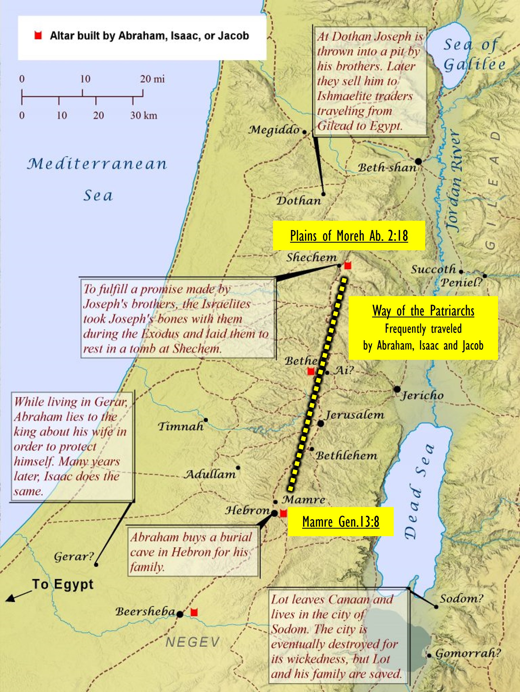
Bible Plains PLAINS OF MOREH ABRAHAM 2:17-18
 17 Now I, Abraham, built an in the land of Jershon, and made an offering unto the Lord, and prayed that the might be turned away from my father’s house, that they might not perish.
18 And then we passed from Jershon through the land unto the place of Sechem; it was situated in the plains of Moreh, and we had already come into the borders of the land of the , and I offered there in the plains of Moreh, and called on the Lord devoutly, because we had already come into the land of this idolatrous nation.
Shechem
 “Located in the Hill Country of Ephraim, the city of Shechem played a vital role in the history of Israel. This location, in the middle of the nation, provided the most important crossroads in central Israel. The city lay along the northern end of “The Way of the Patriarchs.” This road, also called the “Ridge Route” (because it followed a key mountain ridge stretching 50 miles south), traveled from Shechem through Shiloh, Bethel/Ai, Ramah, Gibeah, Jerusalem, Bethlehem, and Hebron. This route appears continuously in the Biblical text.”
“Amidst the mountains of Shomron (Samaria) is a four-thousand year old city named Shechem. Very few biblical locales have as rich a history as this storied city. In fact, when the first Jew arrived in the Holy Land, Shechem was his first stop. In this city, also known as Nablus, lie the remains of Joseph, viceroy of Egypt. In recent times, modern-day Jewish heroes have struggled to maintain a Jewish presence in Shechem and Joseph’s Tomb.” Chabad.org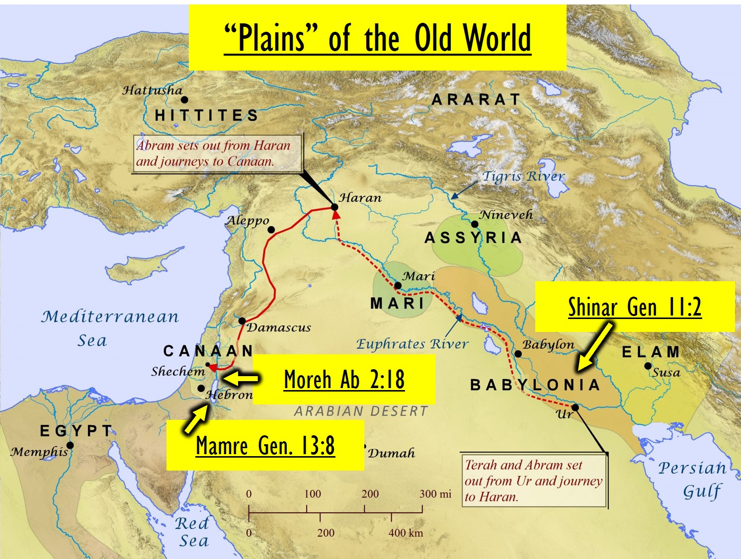
Parallels of the Tribe of Joseph and the Tribe of Judah in the Old World
So in Canaan [Old World], Shechem was in the Land North in the Land of Ephraim and Hebron was in the Land South in the land of Judah. These were the kingdoms of Northern Israel, (Ephraim) and the kingdom of Southern Israel, (Judah). Both brothers of Jacob or Israel and yet both moving in their own direction of Apostasy.
In Cainan (Moses6:17), or the Land of Joseph or the United States has the Land North for the Nephites north above the Ohio River, and the Land South for the Lamanites was south below the Ohio River. (See Map Above) Parallels of the Old World and New World.
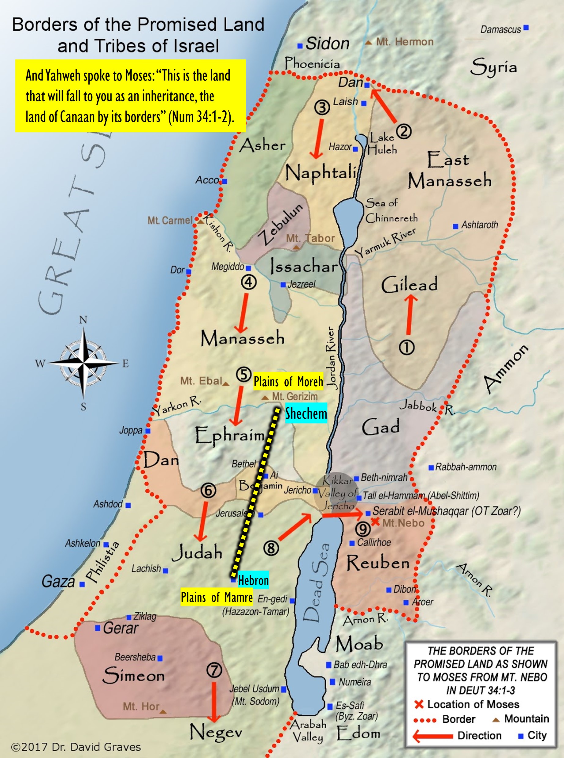
Way of the Patriarchs and the Plains of the Nephites.
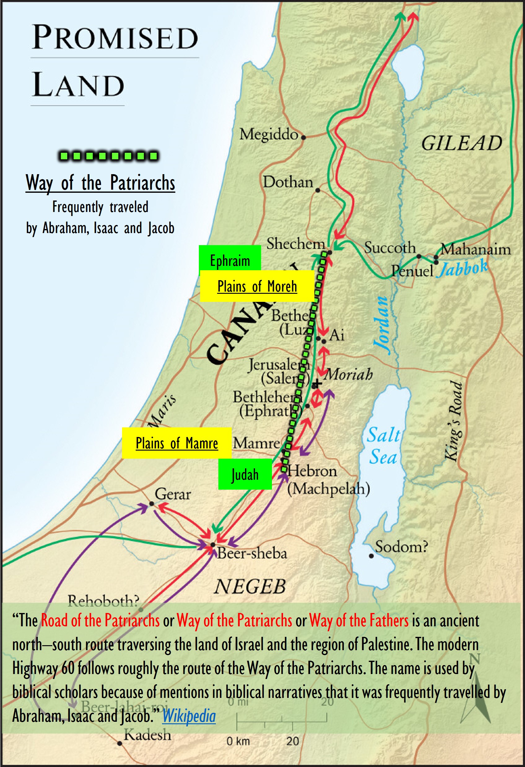 The Road of the Patriarchs or Way of the Patriarchs (Hebrew: דֶּרֶךְ הֲאָבוֹת Derech haʾAvot Lit. Way (of) the Fathers) is an ancient north–south route traversing the land of Israel and the region of Palestine.[1] The modern Highway 60 (Israel-Palestine) follows roughly the route of the Way of the Patriarchs.[2][3]
The name is used by biblical scholars because of mentions in biblical narratives that it was frequently travelled by Abraham, Isaac and Jacob.[4]
It is also called the Hill Road or the Ridge Route[2] because it follows the watershed ridge line of the Samarian and Judaean Mountains. It runs from Megiddo and Hazor south to Beersheba by way of Shechem,[5] Bethel, Jerusalem, Ephrath and Hebron. Unlike the Via Maris and the King’s Highway which were international roads crossing the territories of many peoples, the Ridge Route was wholly within the territory of ancient Israel.[citation needed] https://en.wikipedia.org/wiki/Way_of_the_Patriarchs
This “Ridge Route” in Samaria or the Way of the Patriarchs, could be equivalent to the “Plains of the Nephites” in Illinois of the New World.
Here we define “Plains” worldwide
“A plain is a broad area of relatively flat land. Plains are one of the major landforms, or types of land, on Earth. They cover more than one-third of the world’s land area. Plains exist on every continent.
Many plains, such as the Great Plains that stretch across much of central North America, are grasslands. A grassland is a region where grass is the main type of vegetation.
In North America, temperate grasslands—those in places with warm summers and cold winters—are often called prairies. In areas with little rain and snow, short grasses grow. In areas that receive more rain and snow, tall grasses can grow 1.5 meters (5 feet) high. However, most tallgrass prairies have been plowed under and are now farmland or pasture.
The Great Plains have supported a wide variety of cultures for thousands of years. The so-called “Plains Indians” are actually more than two dozen tribes. Communities include Blackfoot, native to the Canadian province of Alberta; Arapaho, whose center today is in the U.S. state of Wyoming; and Kickapoo, many of whom live today in the Mexican state of Coahuila.
In Asia and eastern Europe, temperate grasslands are called steppes. Steppes usually do not receive enough rain for tall grasses and trees to grow.
Tropical grasslands are called savannas. Savannas exist in places that are warm throughout the year. They often have scattered trees. Savannas such as the Serengeti plains stretch across much of central Africa. They are also found in Australia, South America, and southern North America.
Not all plains are grasslands. Some, such as Mexico’s Tabasco Plain, are forested. Forested plains have different types of trees, shrubs, and other vegetation.
Deserts can also be plains. Parts of the Sahara, a great desert in North Africa, are plains.
In the Arctic, where the ground is frozen, plains are called tundra. Despite the cold, many plants survive here, including shrubs and moss.” National Geographic
My Conclusion:
In North America and parts of Canada “plains” would be defined as: Grasslands and Prairies. A grassland is a region where grass is the main type of vegetation. In South and Central America “plains” would be defined as: Forested Plains with different trees and shrubs or as Savannahs.
I believe the North American geography with the defined plains, are the best interpretation for the types of land described in the Book of Mormon with reference to “plains.” Perfect land for Buffalo, Horses, domesticated animals and animals who migrate and graze. In Central and South America which are below the equator, are more like Savannah’s and Forested plains with trees and shrubs is more of a jungle type of land for birds and smaller animals, that don’t migrate. In Mesoamerica there are only two animals that migrate, (Turkey and Butterflies). Ether 9:34 which says, “And it came to pass that the people did follow the course of the beasts, and did devour the of them which fell by the way, until they had devoured them all.” This sounds like buffalo or elk or bear from North America, not small Llamas or Jaguars from Mesoamerica who don’t migrate.
Let’s define more specifically, “Plains” of the United States:
“The Great Plains (French: Grandes Plaines), sometimes simply “the Plains”, is a broad expanse of flatland in North America. It is located west of the Mississippi River and east of the Rocky Mountains, much of it covered in prairie, steppe, and grassland. It is the southern and main part of the Interior Plains, which also include the tallgrass prairie between the Great Lakes and Appalachian Plateau, and the Taiga Plains and Boreal Plains ecozones in Northern Canada. The term Western Plains is used to describe the ecoregion of the Great Plains, or alternatively the western portion of the Great Plains.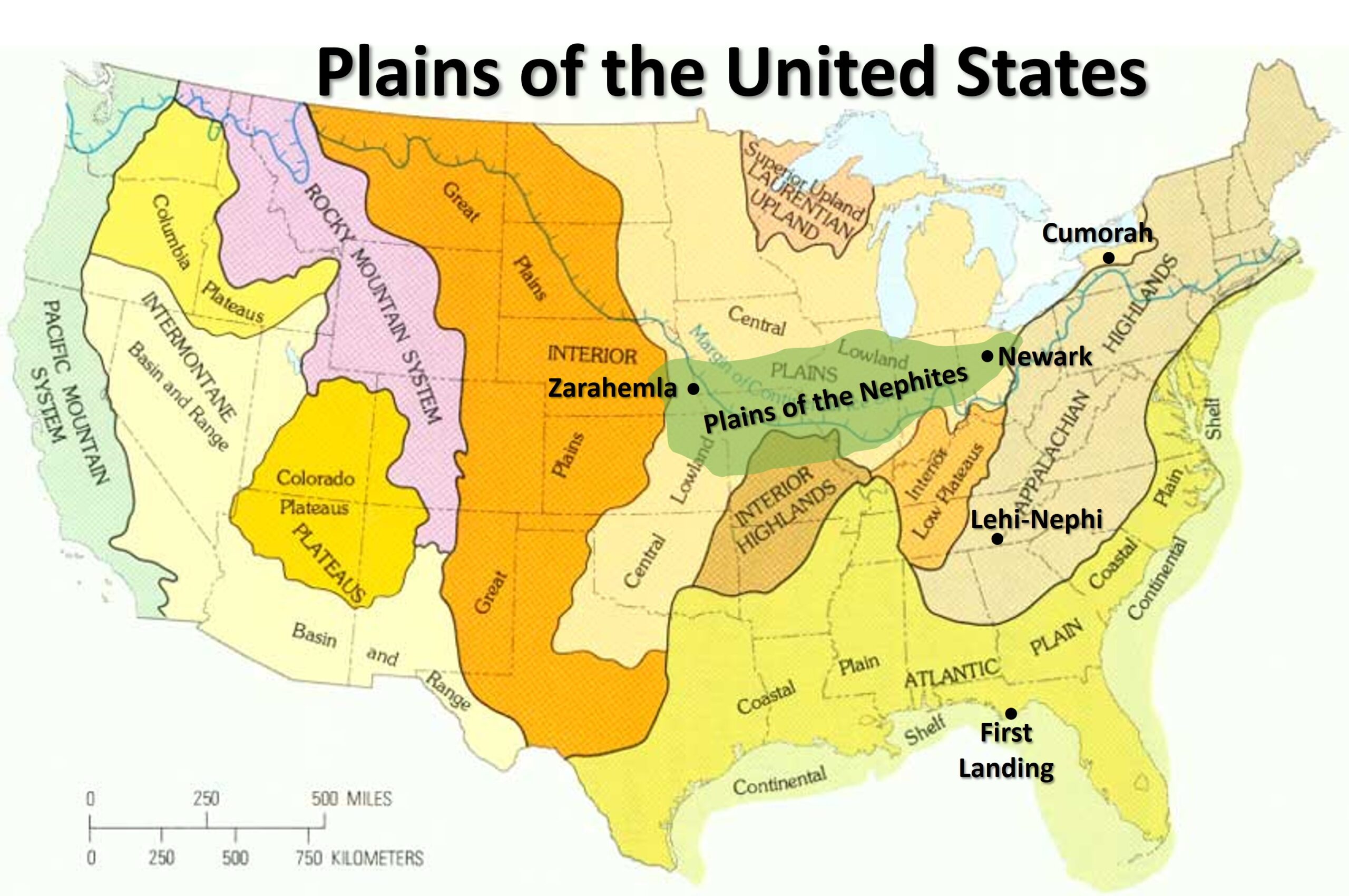
The Great Plains lies across both Central United States and Western Canada, encompassing:
The entirety of the U.S. states of Kansas, Nebraska, North Dakota and South Dakota; Parts of the U.S. states of Colorado, Iowa, Minnesota, Missouri, Montana, New Mexico, Oklahoma, Texas and Wyoming;
The southern portions of the Canadian provinces of Alberta, Saskatchewan and Manitoba. The term “Great Plains” usually refers specifically to the United States portion of the ecozone while the Canadian portion is known as the Canadian Prairies. In Canada it covers southeastern Alberta, southern Saskatchewan and a narrow band of southwestern Manitoba, these three provinces collectively known as the “Prairie Provinces”. The entire region is known for supporting extensive cattle-ranching and dryland farming.
Grasslands are among the least protected biomes with vast areas having been converted for agricultural purposes and pastures…. In general, the Great Plains have a wide range of weather, with very cold and harsh winters and very hot and humid summers. [Heartland not Mesoamerica] Wind speeds are often very high, especially in winter. “Wikipedia
Any plains in Mesoamerica would not have a wide range of weather and very few whirlwinds if any. Whirlwinds are mentioned in the Book of Mormon often which could be tornados as well. See my blog here for more about whirlwinds and tornados vs volcanoes.
USGS Survey WHAT IS THE GREAT PLAINS?
“The United States has been subdivided into physiographic regions that, although they have great diversity within themselves, are distinctly different from each other (fig. 2). From the Rocky Mountains on the west to the Appalachians on the east, the interior of our country is a vast lowland known as the Interior Plains. These plains are bounded on the south by a region of Interior Highlands, consisting of the Ozark Plateaus and the Ouachita province, and by the Coastal Plain. In the Great Lakes region, the Interior Plains laps onto the most ancient part of the continent, the Superior Upland. West of the Great Lakes it extends far to the north into Canada. Certainly the Rocky Mountains are distinctly different from the region to the east, which is the Great Plains. The Great Plains, then, is the western part of the great Interior Plains. The Rocky Mountains form its western margin. But what determines its eastern margin?
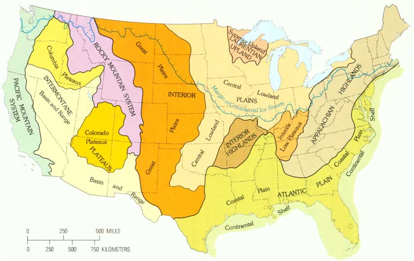 |
| Figure 2.—Physical divisions of the United States and maximum extent of the continental ice sheets during the Great Ice Age. (click on image for an enlargement in a new window) |
During the Pleistocene Epoch or Great Ice Age [I don’t trust the aging of the earth], huge glaciers formed in Canada and advanced southward into the great, central, low-lying Interior Plains of the United States. (See figure 2.) These glaciers and their deposits modified the surface of the land they covered, mostly between the Missouri and the Ohio Rivers; they smoothed the contours and gave the land a more subdued aspect that it had before they came. This glacially smoothed and modified land is called the Central Lowland. Although the ice sheets lapped onto the northern part, the Great Plains is the largely unglaciated region that extends from the Gulf Coastal Plain in Texas northward into Canada between the Central Lowland and the foot of the Rocky Mountains. Its eastern margin in Texas and Oklahoma is marked by a prominent escarpment, the Caprock escarpment. Its southern margin, where it abuts the Coastal Plain in Texas, is at another abrupt rise or scarp along the Balcones fault zone.” Source
Where is the Ancient Americas?
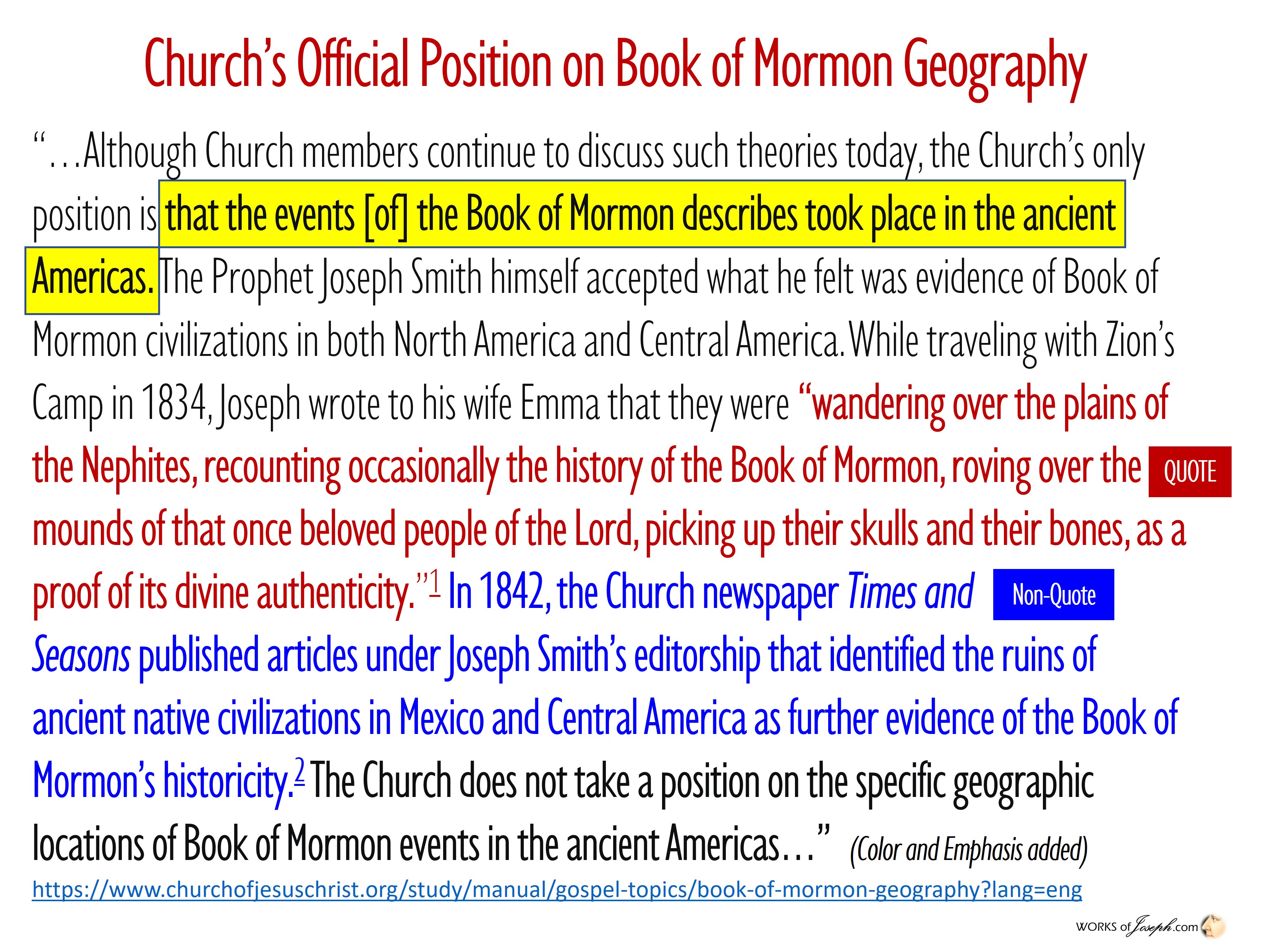
First let me speak to the position of The Church of Jesus Christ of Latter-day Saints, on their opinion about the geography of the Book of Mormon. Below is their Gospel Topic Essay where it shows their position as, “the Church’s only position is that, “the events the Book of Mormon describes took place in the ancient Americas.” This is understood and I am fine with their position. (I also know these Essay’s were written by historians and scholars who have their own bias and opinions about these matters). Yes, these Essay’s were approved by the Brethren to be shared [Not necessarily read by the leading Brethren but by the Historians and Intellects who they have trusted], but the church remains neutral as to where the geography exactly happened. I personally think the Book of Mormon Geography happened beginning in the Heartland of the United States, with Lehi leaving Oman and landing in Florida. If you were to ask each Prophet and Apostle where they personally think the Book of Mormon Geography happened, more than likely they would have many varying opinions.
Hugh B. Brown said, “And while all members should respect, support, and heed the teachings of the authorities of the church, no one should accept a statement and base his or her testimony upon it, no matter who makes it, until he or she has, under mature examination, found it to be true and worthwhile; then one’s logical deductions may be confirmed by the spirit of revelation to his or her spirit, because real conversion must come from within.” – Apostle Hugh B. Brown, “A Final Testimony,” from An Abundant Life, 1999
I Believe Prophets and Leaders about North America Below
I truly believe with all my head and heart that the Book of Mormon events began in the Heartland of the United States. I agree with President Monson who said, “The Lord gave a divine promise to the ancient inhabitants of this favored country (the United States): ‘Behold, this is a choice land, and whatsoever nation shall possess it shall be free from bondage, and from captivity, and from all other nations under heaven, if they will but serve the God of the land, who is Jesus Christ” (Ether 2:12). Our Heavenly Father inspired the leaders of…the United States of America,that they might together, under His direction, having been raised up by God for the purpose, establish the Constitution of this country and…Bill of Rights, that by the year of our Lord 1805 [there would be] a climate where our Heavenly Father could send into this period of mortality a choice spirit who would be known as Joseph Smith, Jr.” Teachings of Thomas S. Monson by Thomas S. Monson 2011 (Ordained an Apostle, 1963; ordained President of the Church, 2008)
Also Elder McConkie said, “Certain lands were given to Israel for an inheritance in time and in eternity. America is the land of Joseph; it was the home of Nephite Israel, who were of Joseph, for a thousand years, and it is the headquarters of the Church in this final dispensation in which the church and kingdom of God are in the lands of Ephraim.” 1985 – Elder Bruce R. McConkie
Prophets Testify, The Book of Mormon began in North America.
President Benson said, “Nephi then continues his record: And I beheld the Spirit of the Lord, that it was upon the Gentiles [the American colonies] and they did prosper and obtain the land for their inheritance. . . .And it came to pass that I, Nephi, beheld that the Gentiles who had gone forth out of captivity [from Europe] did humble themselves before the Lord; and the power of the Lord was with them. [1 Nephi 13:15, 16]
This refers, of course, to the American colonists… Consider how very fortunate we are to be living in this land of America. Many great events have transpired in this land of destiny. This was the place where Adam dwelt; this was the place where the Garden of Eden was located. It was here that Adam met with a body of great high priests at Adam-ondi-Ahman shortly before his death and gave them his final blessing, and the place to which he will return to meet with the leaders of his people.
This was the place of three former civilizations: Adam’s, the Jaredite, and the Nephite. This was also the place where our Heavenly Father and his Son, Jesus Christ, appeared to Joseph Smith inaugurating this great and last dispensation. The Lord has also decreed that this land should be “the place of the New Jerusalem, which should come down out of heaven, . . . the holy sanctuary of the Lord” (Ether 13:3). Here is our nation’s destiny! To serve God’s eternal purposes and to prepare this land and people for America’s eventual destiny, he “established the Constitution of this land, by the hands of wise men whom [he] raised up unto this very purpose, and redeemed the land by the shedding of blood” (D&C 101:80). The Teachings of Ezra Taft Benson pp. 587-588 https://speeches.byu.edu/talks/ezra-taft-benson_gods-hand-nations-history/
Stretch Beyond Your Current Spiritual Ability
I have strong opinions that have been formed as personal revelation to me on important subjects. Not doctrine for The Church of Jesus Christ of Latter-day Saints, not absolute truth, as I am only a man of the flesh, but these personal revelations have come as very strong opinions of the spirit that I can’t deny. I only expect you to agree with me, as you feel so personally inspired to do so. I am sharing some things here that are very personal, but I feel many of you may be struggling with some issues or questions yourself that this information may be comforting to you, or allow the spirit to work with you directly about sensitive issues of importance. Some may feel these glimmers of personal revelation are not true to me and not important, but that is only your opinion. I feel this blog is of vital importance to one or many who may read it. I appreciate you listening.
President Nelson said, “I urge you to stretch beyond your current spiritual ability to receive personal revelation, for the Lord has promised that “if thou shalt [seek], thou shalt receive revelation upon revelation, knowledge upon knowledge, that thou mayest know the mysteries and peaceable things—that which bringeth joy, that which bringeth life eternal.” Revelation for the Church, Revelation for Our Lives by President Russell M. Nelson.I trust our Prophet and love him and our Savior.
Book of Mormon Geography Matters
“God intends us to find and use the evidence He has given—reasons, if you will—which affirm the truthfulness of His work….” The Greatness of the Evidence By Elder Jeffrey R. Holland August 16, 2017
More on the “PLAINS of the NEPHITES”
This quote below from the Prophet Joseph Smith, in a letter he sent to his wife Emma in 1834 while he was on Zion’s Camp March, is very true to me.
You can also see the Church of Jesus Christ of Latter-day Saints has used this quote in Gospel Essay’s above in red, in describing an important truth to consider about the correct geography of the Book of Mormon. The explanation below is the Mesoamerican opinion of the geography about the Book of Mormon which is also found in the Gospel Essay.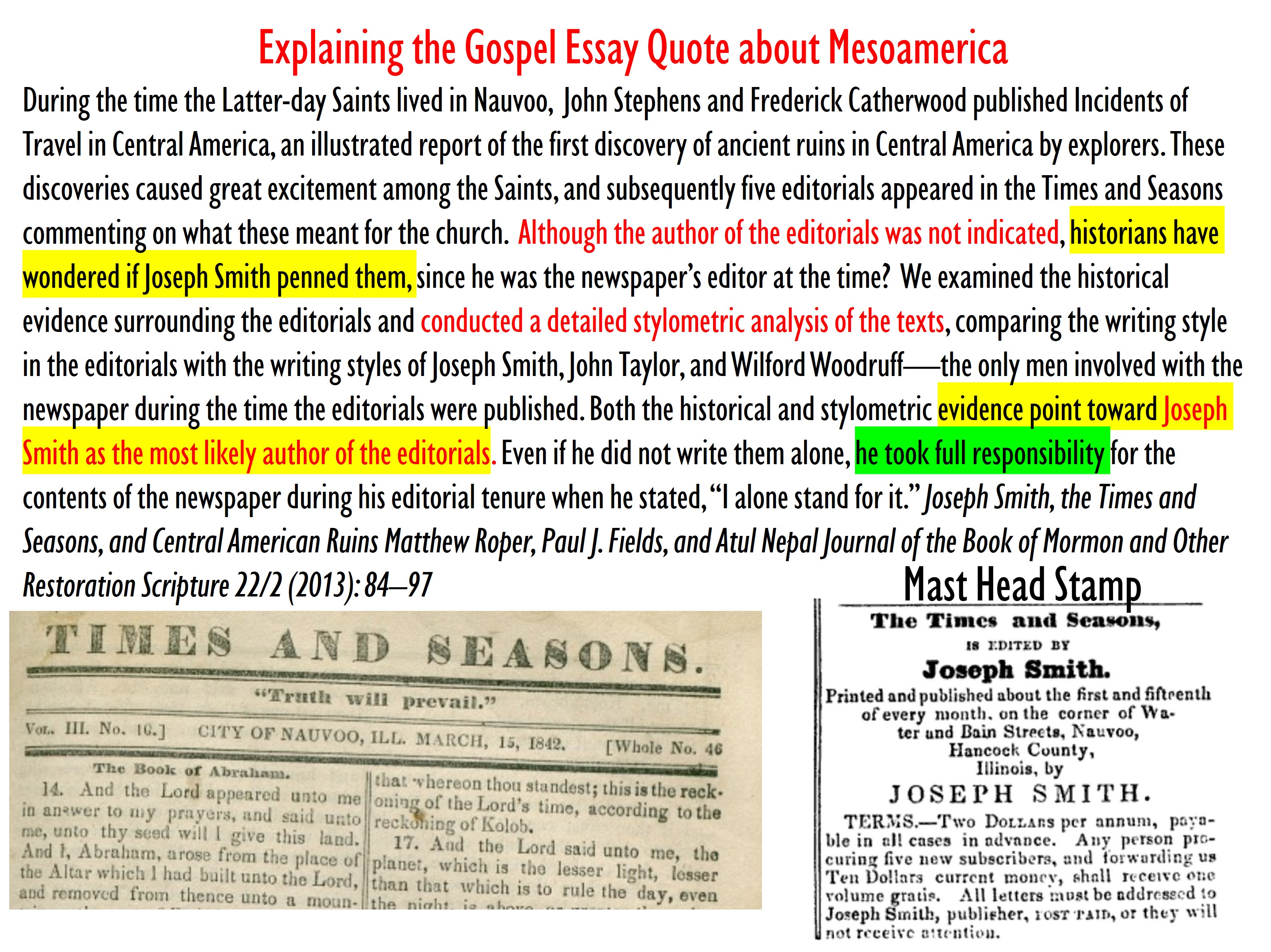
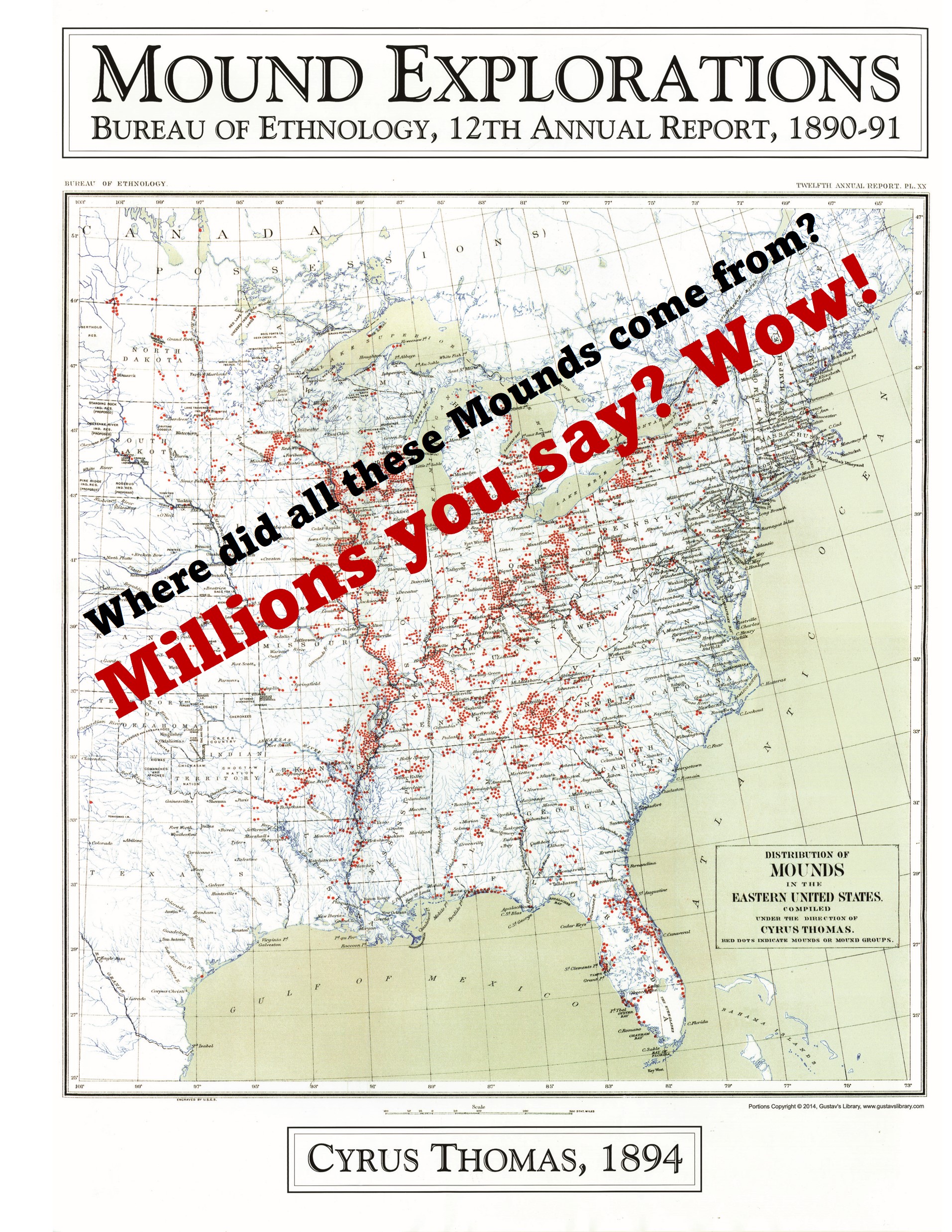 There are hundreds of thousands of Indian Mounds in North America, (Map left) that I never even knew about, until 53 years of age. Yet, the mounds, and cities and cultures of the Native Americans in North America were hidden, so to speak from the world in open spaces with thousands of artifacts in museums all over the land? Here is what a Historian said about this map left:
“…This modernistic theory of necessity, in order to be consistent, must place the waters of Ripliancum and the Hill Cumorah some place within the restricted territory of Central America, notwithstanding the teachings of the Church to the contrary for upwards of 100 years. Because of this theory some members of the Church have become confused and greatly disturbed in their faith in the Book of Mormon. It is for this reason that evidence is here presented to show that it is not only possible that these places could be located as the Church has held during the past century, but that in very deed such is the case… It is known that the Hill Cumorah where the Nephites were destroyed is the hill where the Jaredites were also destroyed. This hill was known to the Jaredites as Ramah. It was approximately near to the waters of Ripliancum, which the Book of Ether says, “by interpretation, is large, or to exceed all… It must be conceded that this description fits perfectly the land of Cumorah in New York, as it has been known since the visitation of Moroni to the Prophet Joseph Smith, for the hill is in the proximity of the Great Lakes and also in the land of many rivers and fountains. Moreover, the Prophet Joseph Smith himself is on record, definitely declaring the present hill called Cumorah to be the exact hill spoken of in the Book of Mormon. Further, the fact that all of his associates from the beginning down have spoken of it as the identical hill where Mormon and Moroni hid the records, must carry some weight. It is difficult for a reasonable person to believe that such men as Oliver Cowdery. Brigham Young, Parley P. Pratt, Orson Pratt, David Whitmer, and many others, could speak frequently of the Spot where the Prophet Joseph Smith obtained the plates as the Hill Cumorah, and not be corrected by the Prophet, if that were not the fact. That they did speak of this hill in the days of the Prophet in this definite manner is an established record of history.” Doctrines of Salvation Joseph Fielding Smith Chapter 12 Is this man lying? Is he pretending? Is he misquoted? Is this just an opinion or is it his personal revelation? I have read and studied a lot, but not even close to the amount of time Elder Smith did, but I have to come to the same conclusion as he and Elder Perry I repeat who said, “The United States is the promised land foretold in the Book of Mormon” Elder L. Tom Perry Ensign Dec. 2012
The Book of Mormon indeed speaks of the land of the United States of America. Not Russia, not Guatemala, not England, not Canada or Mexico, but the choice land of the United States of America where Adam was placed and the same place the New Jerusalem will be built. I cannot and will not doubt the hundreds (list here) of prophets and apostles that have agreed that the Book of Mormon began in the Heartland. I can’t find one quote where Joseph Smith said the Book of Mormon began in Mesoamerica. Not even the quote in the Times and Seasons found in the Gospel Essay’s, (Linked below) is proven to be Joseph’s words. But the quote in the letter from Joseph to his wife Emma on June 2, 1834 when he said, “a proof of its divine authenticity“, also quoted later, says it all.
Below is from Moroni’s America page 318-9
Here’s Wright’s explanation: [Mark Wright is a strong believer of the Mesoamerican theory]
“Likewise, the “plains of the Nephites” are never mentioned in the Book of Mormon. To be sure, there are “plains” mentioned between the cities Bountiful and Mulek in Alma 52:20, and we read of the “plains of Nephihah” in Alma 62:18, but the general term “plains of the Nephites” is absent from the Book of Mormon. Because there are multiple plains attested to in the text, the general phrase “plains of the Nephites” is too vague to be of any use in pinpointing it geographically. Even among the Jaredites we read of the “plains of Heshlon” (Ether 13:28) and the “plains of Agosh” (Ether 14:15), but significantly, never just “the plains of the Jaredites.” Plains in the text of the Book of Mormon are always attached to a specific city. Those in Joseph’s letter to Emma are not.”
Neville says, “Wright overlooks two obvious points. First, Joseph could have been referring to all of the plains mentioned in the Book of Mormon. After all, he had traversed Ohio, Indiana, and Illinois—a distance of over 650 miles, most of it consisting of plains—by the time he wrote the letter to Emma. Why would he feel compelled to cite specific names from the text, especially when one of the plains Wright himself refers to was not named? Second, Joseph’s mother related how Joseph described the Nephites as if he had lived among them. He could have been aware of additional Nephite plains not specifically named in the Book of Mormon. If so, and if he knew he had just crossed them, one would expect him to describe them as plains, plural, just as he did. In this connection, Wright quotes but avoids addressing the balance of Joseph’s letter, in which Joseph wrote that he spent the time “recounting occasionally the history of the Book of Mormon, roving over the mounds of that once beloved people of the Lord, picking up their skulls & their bones, as proof of its divine authenticity.” In Wright’s view, Joseph was recounting the history of Mesoamerica, picking up skulls and bones in Ohio as proof of the divine authenticity of a Mesoamerican record.
Despite these problems applying the hinterlands approach to North America, the hinterlands approach has many promising implications and suggests new avenues for additional research—especially if it is applied in the opposite direction. I propose that the text of the Book of Mormon, considered in light of the historical, geographical, archaeological, and geological evidence, points to Mesoamerica as the hinterlands to the Book of Mormon narrative. Under this approach, the bulk of the narrative, from the land of Nephi to Zarahemla to Cumorah, took place in North America.
In Mormon’s Codex,[ii] John Sorenson proposed using filters to assess any proposed setting. It’s an effective approach, so this chapter applies the filters Sorenson formulated, along with three additional filters based on the text of the Book of Mormon itself. It thus sets aside the Times and Seasons articles and other extra-textual statements to focus on the merits of Mesoamerican theories based on the text of the Book of Mormon and other scriptures.” Moroni’s America Page 318-319
[i] Ibid, p. 118. Wright erroneously claims Joseph’s letter “was actually penned by James Mulholland and then signed by Joseph.” His citation to the Joseph Smith Papers explains that the version of the letter is in Mulholland’s handwriting, but it is found in JS Letterbook 2, which is a book containing copies of Joseph’s correspondence—not the actual correspondence. Mulholland was one of seven scribes who copied material into Letterbook 2. Mulholland was not a participant on Zion’s Camp and could not have written the original letter.
[ii] John L. Sorenson, Mormon’s Codex (Deseret Book, Salt Lake City, UT 2013), pp. 20-21.