Allen C. Christensen. Before Zion: An Account of the Seventh Handcart Company. Springville, Utah: Council Press, 2004. x, 356 pp.
The mention of the Mormon handcart trek west inevitably brings associations of the ill-fated Willie and Martin handcart companies. Theirs was a tragic tale, filled with suffering, starvation, and death as they sought to make their way to Utah. These two companies, however, were only two of ten who came to Utah between 1856 and 1860.
Allen Christensen has written the history of the seventh handcart company, which traveled farther and faced its own challenges to reach Zion.
This company has been largely unknown, not only overshadowed by the great tragedy of the Martin and Willie companies but also because it was made up primarily of Scandinavians. Hence, their story was less accessible to English speakers. Christensen, a great-grandson of company member Niels Christensen, preserves both the story and the legacy of this company through the use of company member journals, letters to family members, and histories written about the church and Scandinavia.
Christensen’s purpose is to portray these pioneers’ emigration as “an eloquent testament to their acceptance of the divinity of the restoration of the Church of Jesus Christ” (136).
In the first part, “Scandinavian Beginnings,” Christensen sets the stage for the departure of the Seventh Company by describing missionary efforts in Scandinavia during the early 1850s. While the work was slow at first, given the power of the Lutheran clergy, the missionaries began baptizing converts, who in turn began planning on going to Zion. Saints from Norway and Sweden sailed to Copenhagen, where they joined with Danish converts in sailing to Liverpool on April 17, 1857, during the first leg of their long voyage. They landed in Liverpool on April 22 and left for America three days later, landing in Philadelphia on May 30 and traveling by train to Iowa City.
The second part of the book, “Handcarts West,” covers their departure from Clear Creek, Iowa, on June 12 under the direction of Captain Christian Christiansen. Their travel coincided at times with the march of the Utah Expedition before the tired pioneers pushed hard to get ahead of Johnston’s Army. They reached the Salt Lake Valley on Sunday, September 13, grateful for their safe arrival. After the company’s arrival, the members began settling in different areas throughout Utah Territory, spanning present-day Davis and Box Elder counties all the way to Sanpete County.
While every member of the Seventh Company is listed on the ship roster in the first appendix, Christensen focuses specifically on several individuals and their challenges during the trek. Anna Marie Sorensen, halfway through the trek, gave birth one night and continued walking the next day. Margrette Ohlsen Englestead Hansen was widowed for the second time during the trek west. Lars and Ane Pedersen and Anders and Ingerline Jensen each buried a baby at sea while sailing across the Atlantic.
By Clark Kelley Price
In addition to the hardships endured by different members of the company, Christensen also writes about what they did afterwards. Many members of the Seventh Company were farmers, a trade that was much needed at that time in Utah. In addition, several of the company’s men were skilled craftsmen who put their talents to good use, including helping to build the Manti Temple.
The influence of the Seventh Company continues even today. In the book’s epilogue, Christensen outlines what happened to the descendants of members of the company. His own great-grandfather, Niels Christensen, has many descendants active in the LDS faith, with some serving as stake presidents, bishops, mission presidents, and in many other callings. Other members of the company also have faithful families, undoubtedly inspired by what these Scandinavian pioneers went through to reach Zion.
The following account comes from pages 231-232 of the above book.
“Accounts tell that one morning after the 7th Company had been without meat for several weeks, they passed a large, fat ox which had been left behind by the army. A loaded wagon had crushed its foot. The army gave them the ox for meat. Niels Christensen remembered the army gave them the ox with the understanding that the pioneers would butcher and dress it for half of the carcass, and that the soldiers would pick up their half the next evening. During the night heavy rain fell; the ground was so muddy that the supply wagons could move only slowly. The saints pulled their light handcarts out onto the grass alongside the trail. That day some Indians carried the women and children across the stream on the backs of their ponies. That night, however, under the cover of darkness, the Indians drove off the horse which pulled the U.S. Army’s supply wagons. By the next evening the pioneers were so far ahead of the army, the 7th Company did not see them again. The hungry Scandinavian saints ate the hole carcass.
Descendants of Jacob Bastian remembered that Jacob and another company member had been sent to get the lame ox. Jacob was beginning to understand English at a level where he could understand the gist of what was going on said; he even spoke a little English by this point in the journey. Gertrude had learned English in school. She interpreted for him and must have been his English tutor. While he and the other man were there, a rider came galloping in from the west carrying a wild tale of some alleged Mormon atrocity. Jacob’s companion spoke no English. Jacob has the distinct impression that he should remain silent and act as though he did not understand. The conversation became agitated and nasty. There were those who wanted to kill Jacob and the other fellow on the spot, and then destroy all of those “wretched Mormons!” Among those solders was a Sergeant Anderson, a Swedish American. He challenged his comrade in arms saying: “What is the matter with you men? You are beginning to behave like bloodthirsty savages. These people could not have anything to do with that. They are immigrants. They don’t speak English. They are even ignorant of their present danger. You know they have traveled peacefully ahead of us for miles. I will kill the first man who molests them.” So persuasively confronted, their passions cooled. The Scandinavians were given the lame ox and the pioneers went west.” Before Zion: An Account of the 7th Handcart Company. Taken from pages 231-232 Allen C Christensen Author and copyright holder Permission is given Rian Nelson to quote the foregoing in his blog.
Before Zion: An Account of the Seventh Handcart Company by Allen C. Christensen
Though young in the Church, the Scandinavian Saints of the seventh handcart company left their farms and shops to follow the restored gospel of Jesus Christ. They taught His gospel throughout Denmark, Norway, and Sweden where they were beaten by mobs, jailed, and survived on diets of bread and water; they, like Peter and John, were grateful to be counted worthy to suffer in Jesus name.
But the trek west would stretch this group of farmers and artisans further still, as they placed their all on the altar of sacrifice in their quest for Zion.
The members of the 7th Company were ordinary people who by virtue of their faith in the gospel became remarkable people who accomplished extraordinary things. This is their story. Purchase Here: or Here
Here is another fantastic book by Allen C. Christensen.
Allen Christensen’s new book (2019) titled, Joseph’s Remnant: Lamanties in Today’s America, involves biographical sketches of a number of Native American Latter-day Saints. Their lives and their struggles to achieve are many and varied. Aspects of their several tribal cultures are also considered as well as their long overlooked contributions as America’s first citizens. He includes real stories about Elder Larry Echo Hawk, Franklin Keel, Betty “Red Ant” LaFontaine, Delores Kahkonen and many others. 240 pages
Joseph’s Remnant: An Introduction by Allen C. ChristensenBuy Here
“The Savior’s ministry exemplifies the two great commandments: “Thou shalt love the Lord thy God with all thy heart, and with all thy soul, and with all thy mind” and “Thou shalt love thy neighbour as thyself” (Matthew 22:37, 39). In that spirit, Jesus also taught, “Ye are they whom I have chosen to minister unto this people” (3 Nephi 13:25)… The separate programs of home teaching and visiting teaching are now a coordinated effort referred to as “ministering,” overseen by the elders quorum and Relief Society presidencies under the direction of the bishop. Ministering is Christlike caring for others and helping meet their spiritual and temporal needs.” The First Presidency April 2, 2018. Russell M. Nelson, Dallin H. Oaks, Henry B. Eyring.
“Brothers and sisters, as the work of quorums and auxiliaries matures institutionally, it follows that we should mature personally as well—individually rising above any mechanical, function-without-feeling routine to the heartfelt discipleship articulated by the Savior at the conclusion of His earthly ministry. As He prepared to leave His still-innocent and somewhat-confused little band of followers, He did not list a dozen administrative steps they had to take or hand them a fistful of reports to be filled out in triplicate. No, He summarized their task in one fundamental commandment: “Love one another; as I have loved you. … By this shall all men know that ye are my disciples, if ye have love one to another… The primary purpose in this ministering idea will be, as was said of the people in Alma’s day, to “watch over their people, and … nourish them with things pertaining to righteousness… I should stress that this expansive new view does not include the sorry statement I recently saw on an automobile bumper sticker. It read, “If I honk, you’ve been home taught.” Please, please, brethren (the sisters would never be guilty of that—I speak to the brethren of the Church), with these adjustments we want more care and concern, not less.” Jeffrey R. Holland April 2018
How are we living? Are we striving to live the Higher Law? Higher Law vs. Lower Law
Consecration vs Tithing
Celestial Marriage vs. Temporal Marriage
Spirit of the Law vs Letter of the Law
Ministering vs Home Teaching
Law of the Gospel vs Law of Moses
Love vs Duty
Priesthood Ministering- TEND TO, CARE FOR, TAKE CARE OF, LOOK AFTER, NURSE, TREAT, ATTEND TO, SEE TO, ADMINISTER TO, HELP, ASSIST AND MORE
The Savior Jesus Christ came to earth to minister to others, spending His days in their service and giving His life for their salvation. Matthew 20:27-28 “And whosoever will be chief among you, let him be your servant: Even as the Son of man came not to be ministered unto, but to minister, and to give his life a ransom for many.”
What would the Savior do if He was in your Ward? (Minister)
Click to view pages from our Annotated Book of Mormon
3 Nephi 19:2, 7-8 “And it was noised abroad among the people immediately, before it was yet dark, that the multitude had seen Jesus, and that he had ministered unto them, and that he would also show himself on the morrow unto the multitude. And the disciples did pray unto the Father also in the name of Jesus. And it came to pass that they arose and ministered unto the people. And when they had ministered those same words which Jesus had spoken—nothing varying from the words which Jesus had spoken—behold, they knelt again and prayed to the Father in the name of Jesus.”
Moroni 7:22 “For behold, God knowing all things, being from everlasting to everlasting, behold, he sent angels to minister unto the children of men, to make manifest concerning the coming of Christ; and in Christ there should come every good thing.”
I believe ministering requires a passion. What was the Savior’s passion? (Moses 1:39) We are blessed with the Priesthood and the Gospel, but do we have a PASSION for MINISTERING? Is it Duty or Love? What is your passion? School, cars, dolls, computers, vacations, service, writing? Why are these your passions and how can you make MINISTERING your passion? With the Spirit of the Lord in our hearts, WE WILL BECOME PASSIONATE especially about MINISTERING. They go hand in hand.
Joseph Smith Loves the Lamanites
My passion is Lamanites, The Book of Mormon and Joseph Smith! I want to minister to them, for them and about them. I am trying to develop this same passion into being a better person.
My parents both served missions in 1951 to the Lamanites, Hopi, Navajo, Apache, and Isleta tribes of Arizona and New Mexico. I served a mission in Fiji among the Polynesian Lamanites. My son served the Lamanites in Alaska. I have a great love for the Lamanites and feel it is my Duty,I mean Love,to share the Gospel with them. Again this Passion requires love, not duty.
How many of you know about Zelph? Or Onandagus? Did you know Onandagus was a Book of Mormon Prophet? I only recognized this story about 7 years ago, and it has added to my testimony of service to the Lamanites. I know Zelph lived and was a great warrior serving the Nephites against all evil. I know Onandagus was a book of Mormon Prophet as Wilford Woodruff described below:
“During our travels we visited many mounds thrown up by the ancient inhabitants, the Nephites and Lamanites. This morning, June 3rd, we went on to a high mound near the river. From the summit we could overlook the tops of the trees as far as we could see. The scenery was truly beautiful. On the summit of {41}the mound were stones which presented the appearance of three altars, they having been erected, one above the other, according to the ancient order of things. Human bones were seen upon the ground. Brother Joseph requested us to dig into the mound; we did so; and in about one foot we came to the skeleton of a man, almost entire, with an arrow sticking in his backbone. Elder Milton Holmes picked it out, and brought it into the Camp, with one of the leg bones, which had been broken. I brought the thigh bone to Missouri. I desired to bury it in the Temple Block in Jackson County; but not having this privilege, I buried it in Clay County, Missouri, near the house owned by Col. Arthur and occupied by Lyman Wight.”
Click to purchase 150 maps of the Book of Mormon in North America.
“The arrowhead referred to is now in the possession of President Joseph F. Smith, Salt Lake City, Utah. “Brother Joseph,” continues Wilford, “feeling anxious to learn something of this man, asked the Lord, and received an open vision. The man’s name was Zelph. He was a white Lamanite, the curse having been removed because of his righteousness. He was a great warrior, and fought for the Nephites under the direction of the Prophet Onandagus. The latter had charge of the Nephite armies from the Eastern sea to the Rocky Mountains. Although the Book of Mormon does not mention Onandagus, he was a great warrior, leader, general, and prophet.Zelph had his thigh bone broken by a stone thrown from a sling, but was killed by the arrow found sticking in his backbone. There was a great slaughter at that time. The bodies were heaped upon the earth, and buried in the mound, which is nearly three hundred feet in height.” Wilford Woodruff History of his Life and Labors as Recorded in his Daily Journals by Matthias F. Cowley Release Date December 19, 2014 [EBook #47703]
This knowledge of Zelph and Onandagus has inspired me with a new passion of love to share with others this amazing yet seldom told story. You can read more about it in the Joseph Smith Papers Here.
Thomas Mayhew Patriarch to the Indians 1593-1682
Baptism History display at the Washington Cathedral
I am a direct descendant of Governor Thomas Mayhew, the Elder (March 31, 1593 – March 25, 1682) through my father’s mother. Mayhew established the first English settlement of Martha’s Vineyard, Nantucket and adjacent islands in 1642. He is one of the editors of the Bay Psalm Book, the first book published in British North America. His assistant Peter Foulger was the grandfather of Benjamin Franklin.
The Mayhews had great success in regard to Indian policy. Because of the fair treatment of the Indians there, the colony was protected from the bloodshed that occurred elsewhere, in King Philip’s War. In 1646, the General Court of Massachusetts directed the religious leaders of the colony to select two among them to serve as missionaries to the natives. Three prominent names appear. They are: John Eliot (known as the Apostle to the Indians); Thomas Mayhew (Patriarch to the Indians); and Eleazar Wheelock, who established “Doctor Wheelock’s Academy for the promotion of Christianity and civility among the savage Indians of this continent” (now known as Dartmouth College).
Thomas Mayhew baptising Hiacoome
There is a stained glass window in the baptismal font in the National Cathedral in Washington D.C. depicting Rev. Thomas Mayhew Jr. baptizing an Indian named Hiacoomes. Experience Mayhew (1673-1758) was a New England missionary to the Wampanoag Indians on Martha’s Vineyard and adjacent islands. He is the author of Massachusett Psalter (a rare book like Bay Psalm Book and Eliot Indian Bible). He married Thankful, daughter of Thomas Hinckley, Governor of Plymouth Colony. This heritage has rubbed off on me and instilled a Passion, not a Duty to Love the Indians and serve them and teach them. Wow what a passion I have for these wonderful ancestors. I am sure each of you can find a deep passion of love to overtake that feeling of duty we ofttimes feel.
SIGNERS OF THE BOOK OF THE LORD’S COMMANDMENTS
Joseph Smith needed someone to step up and testify of his revelations. Eleven men had testified earlier to the truthfulness of the Book of Mormon. All 11 had seen the plates. Three had seen an angel, handled the plates and heard the voice of God. But in November of 1831 there was a new need for boldness. Who would put their names and reputations on the line? Who would stand up and let the world know that they knew that a collection of Joseph’s revelations, the Book of Commandments, was true? For 178 years the names of these testifiers were unknown. Their names were erased from memory. Now, with the publication of the latest volume of the Joseph Smith Papers: “Revelations and Translations: Manuscript Revelation Books,” their names are made known to the world. I am thankfully related directly to one of those signers, Peter Dustin through by mother’s mother. Because of this, my LOVE not Duty give me the passion to represent Peter Dustin as he bore his witness of Joseph’s divine revelations.
In my opinion the desire and faith necessary to testify about Joseph’s Revelations was possibly more difficult than seeing an angel and the plates. The signers of the Book of Commandments had to have a solid faith in the Lord to feel the Spirit and absolutely know these Revelations were not of Joseph, but of the Lord himself. They based their witness of things they could not see. That is similar for us today. We haven’t seen the plates, but we have felt the Spirit and that Spirit has borne witness to us of the truthfulness of the Book of Mormon. Even some of the Apostles thought they could write Revelations on their own in similar words that the Savior used. they failed miserably. See D&C 67:4-9
Below is the testimony that was signed by these faithful brethren.
“The testimony of the witnesses to the Book of the Lord’s Commandments, which he gave to his church through Joseph Smith, Jr., who was appointed by the voice of the church for this purpose.
We, the undersigners, feel willing to bear testimony to all the world of mankind, to every creature upon the face of all the Earth and upon the islands of the sea, that God hath borne record to our souls, through the Holy Ghost shed forth upon us, that these commandments are given by inspiration of God and are profitable for all men and are verily true. We give this testimony unto the world, the Lord being our helper; And it is through the grace of God, the Father, and his son, Jesus Christ, that we are permitted to have this privilege of bearing this testimony unto the world, in the which we rejoice exceedingly, praying the Lord always, that the children of men may be profited thereby. Amen.”
This is not an original signing of the Book of Commandments
Signers and Witnesses of the Book of Commandments below: Sidney Rigdon
Orson Hyde
Wm. E. McLellin
Luke Johnson
Lyman Johnson
Reynolds Cahoon
John Corrill
Parley Pratt
Harvey Whitlock
Lyman Wight
John Murdock
Calvin Beebe
Zebedee Coltrin
Joshua Fairchild Peter Dustin My 2nd Cousin 2 times removed.
Newel Knight
Levi Hancock; never to be erased
Thomas B. Marsh Deseret News Article Here
This article below was shared with me by a good friend named Ron Mann. Four of the five books written by William George Jordan were quoted in the Improvement Era at the request of the Prophet Joseph F. Smith. He had been introduced to them when he was in New York City. In fact he borrowed the Kingship of Self-Control from the person he was visiting and read it seven times that night. It was after that he had the four books printed in the Improvement Era. This article gives amazing insight to the Duty, vs Love idea. It all comes down to our own Self-Control, and what spirit is guiding us.
Heber J. Grant, President of the Church of Jesus Christ of Latter-Day Saints said it best in a letter to WGJ about one of his books, the Power of Truth, when he wrote: “I know of no book of the same size that has made a more profound impression upon my mind, and whose teachings I consider of greater value.” Article here
About Ron Mann Here: Now, I want you to think about this. Ron worked directly for the leadership of both Houses of Congress. He worked directly for the President of the United States. He worked directly for the Chief Justice of the Supreme Court. He worked directly for the President of the one of the largest corporations in America. And he worked directly for the President of the LDS Church. I bet no one in this room can think of another person who can claim what I’ve just described about Ron Mann.
By William George Jordan as printed in the The Improvement Era, Volume 11, page 751 January 1, 1908 Young Men’s Mutual Improvement Association
Duty is the most over-lauded word in the whole vocabulary of life. Duty is the cold, bare anatomy of righteousness. Duty looks at life as a debt to be paid; love sees life as a debt to be collected. Duty is ever paying assessments; love is constantly counting its premiums.
Duty is forced, like a pump; love is spontaneous, like a fountain. Duty is prescribed and formal; it is part of the red tape of life. It means running on moral rails. It is good enough as a beginning; it is poor as a finality.
The boy who “stood on the burning deck,” and who committed suicide on a technical point of obedience, has been held up to the school children of this century as a model of faithfulness to duty. The boy was the victim of the blind adherence to the red tape of duty. He was placing the whole responsibility for his acts on some one outside himself. He was helplessly waiting for instruction in- the hour of emergency when he should have acted for himself. His act was an empty sacrifice. It was a useless throwing away of a human life. It did no good to the father, to the boy, to the ship or to the nation.
Love vs Duty: Joseph saved his brethren’s lives by jumping out the window.
The captain who goes down with his sinking vessel, when he has done everything in his power to save others, and when he can save his own life without dishonor, is the victim of a false sense of duty. He is cruelly forgetful of the loved ones on shore that he is sacrificing. His death means a spectacular exit from life, the cowardly fear of an investigating committee, or a brave man’s loyal, yet misguided, sense of duty. A human life, with its wondrous possibilities, is two sacred an individual trust to be thus lightly thrown into eternity.
They tell us of the “sublime nobleness” of the Roman soldier of Pompeii, whose skeleton was found centuries afterward, imbedded in the once molten lava which swept down upon the doomed city. He was still standing at one of the gates at his post of duty still grasping a sword in his crumbling fingers. His was a morbid faithfulness to discipline from which a great convulsion of Nature released him. An automaton would have stood there just as long, just as boldly, just as uselessly.
The man who gives one hour of his life to loving, consecrated service to humanity is doing higher, better, truer work in the world than an army of Roman sentinels paying useless tribute to the red tape of duty. There is in this interpretation of duty no sympathy with the man who deserts his post when needed; it is but a protest against losing the essence, the realness of true duty in worshiping the mere form.
Analyze, if you will, any of the great historic instances of loyalty to duty, and whenever they ring true you will find the presence of the real element that made the act almost divine. It was duty,—plus love. It was no mere sense of duty that made Grace Darling risk her life in the awful storm of sixty years ago, when she set out in the darkness of night, on a raging sea, to rescue the survivors of the wreck of The Forfarshire. It was the sense of duty, warmed and vivified by a love of humanity, it was heroic courage of a heart filled with divine pity and sympathy.
Duty is a hard, mechanical process for making men do things that love would make easy. It is a poor understudy to love. It is not a high enough motive with which to inspire humanity. Duty is the body to which love is the soul. Love, in the divine alchemy of life, transmutes all duties into privileges all responsibilities into joys.
The workman who drops his tools at the stroke of twelve, as suddenly as if he had been struck by lightning, may be doing his duty,—but he is doing nothing more. No man has made a great success of his life or a fit preparation for immortality by doing merely his duty. He must do that—and more. If he puts love into his work, the “more” will beeasy.
The nurse may watch faithfully at the bedside of a sick child as a duty. But to the mother’s heart the care of the little one, in the battle against death, is never a duty; the golden mantle of love thrown over every act makes the word “duty” have a jarring sound, as if it were the voice of desecration.
When a child turns out badly in later years, the parent may say, “Well, I always did my duty by him.” Then it is no wonder the boy turned out wrong. “Doing his duty by his son,” too often implies merely food, lodging, clothes and education supplied by the father. Why a public institution would give that! What the boy needed most was deep draughts of love; he needed to live in an atmosphere of sweet sympathy, counsel and trust. The parent should ever be an unfailing refuge, a constant resource and inspiration, not a mere larder or hotel, or wardrobe or school that furnishes these necessities free. The empty boast of mere parental duty is one of the dangers of modern society.
Christianity stands forth as the one religion based on love, not duty. Christianity sweeps all duties into one word,—love. Love is the one great duty enjoined by the Christian religion. What duty creeps to laboriously, love reaches in a moment on the wings of a dove. Duty is not lost, condemned or destroyed in Christianity; it is dignified, purified and exalted, and all its rough ways are made smooth by love.
The supreme instance of generosity in the world’s history is not the giving of millions by some one of great name; it is the giving of a mite by a widow whose name does not appear. Behind the widow’s mite was no sense of duty; it was the full, free and perfect gift of a heart filled with love. In the Bible “duty” is mentioned but five times; “love” hundreds.
In the conquest of any weakness in our mental or moral makeup; in the attainment of any strength; in our highest and truest relation to ourselves and to the world, let us ever make “love” our watchword; not mere “duty.”
Joseph is all about Duty and Love
If we desire to live a life of truth and honesty, to make our word as true as our bond, let us not expect to keep ourselves along the narrow line of truth under the constant lash of the whip of duty. Let us begin to love the truth, to fill our mind and life with the strong white light of sincerity and sterling honesty. Let us love the truth so strongly that there will develop within us, without our conscious effort, an ever-present horror of a lie.
If we desire to do good in the world, let us begin to love humanity, to realize more truly the great dominant note that sounds in every mortal, despite all the discords of life, the great natural bond of unity that makes all men brothers. Then jealousy, malice, envy, unkind words and cruel misjudging will be eclipsed and lost in the sunshine of love. The greatest triumph of the nineteenth century, is not its marvelous progress in invention; its strides in education; its conquests of the dark regions of the world: the spread of a higher mental tone throughout the earth; the wondrous increase in material comfort and wealth,-—the greatest triumph of the century is not any nor all of these; it is the sweet atmosphere of Peace that is covering the nations; it is the growing closer and closer of the peoples of the earth. Peace is but the breath, the perfume, the life of love. Love is the wondrous angel of life that rolls away all the stones of sorrow and suffering from the pathway.” Read more from William George Jordan here.
William George Jordan 1864-1928 was an editor for The Ladies Home Journal, after which he edited The Saturday Evening Post (1888–89). From 1899 to 1905 he was the editor and vice-president of Continental Publishing Company. He was the editor of the publication Search-Light between 1905 and 1906.
The Lord speaking of a Bishop who has a duty to serve but more importantly, “he shall be set apart unto this ministry” D&C 107:74. Again Love as a minister is more important than duty.
As a full time missionary I was set apart as a minister of the Gospel of the Church of Jesus Christ of Latter-day Saints. After accepting my call I now had a duty to serve. However, my love and passion to serve is far more important than duty only.
Is it our Duty to Love, or Love that encourages Duty?
Living the Higher Law of the Lord requires Love and not Duty.
This is part 1 on a six part series of information from a man called Maggid ben Yoseif , who posts many articles of Jewish, Native American, and Christian information. The post is called Jerusalem Torah Voice in Exile. I will be adding my opinion of these articles in the next few months as I feel they are a good source of information. Although Maggid is not a member of The Church of Jesus Christ of Latter-day Saints, his parallels and interpretation of Joseph Smith among the New York Indians is noteworthy. He says the Book of Mormon is fiction, but it is interesting how much value and credence he at times gives it. I feel we need to listen to others opinions to solidify our own feelings of truth.
My notes in orange below:
Bio: Maggid ben Yoseif
ELDERSGATE-BRIGHTSTAR Hebrew Native American Council; Gileadite School of Theological Research; House of Joseph Beit Din. Currently constructing Eldersgate Hebrew-Native American Council promoting restoration of Native American spiritual sovereignty on about 25 acres in rural Brightstar, Arkansas. However, we continue our intercession for the LAND wherever Creator takes us.
We also help ministries and pastors align w/ the “Spirit of Reconciliation” and with the “other flocks” in the Kingdom, especially Native American flocks influenced by the migration of 38 Athap(b)ascan Language Group nations. Traced to ancient pre-Jewish “Gilead” and widely assimilated across Turtle Island (the Americas) this Hebrew priesthood has “evolved” into an End-Times voice of Elijah THE Gileadite to help protect our LIVING Earth Mother, reconcile the factions of the House of Joseph and restore Native American spiritual sovereignty.
Research below links these nations with the migration of DAN, (the “Na Dene”) JOSEPH EAST M’NASHE and priests and Levites of GILEAD. Exiled from their home east of the Jordan River 17-23 years before the 10 Northern Tribes of Israel, unlike the 10 Tribes they were never severed from Covenant. Thus the Sundance and other Native ceremonial chants permute the Divine Name, YHW and H. Restoration of Native spiritual sovereignty is found in Scripture pertaining to purification lodges (sweats) in Hosea 2:18ff, a covenant with the four legged, winged and creatures who crawl to end “sword, bow and violence (FRACKING) in the Earth.” “Goring with the horn of a re’eim” (buffalo) found in Deut 33:15ff describes the buffalo horn used in the lodge by the “n’zir” (East M’nashe). Isaiah 49:6 refers to the RESTORATION — NOT SALVATION — of the “n’zirei Yisrael” as a major part of the assignment of the servant-messiah.
We are eager to share these and many other truths communicated by Elijah over the past 33 years, to lodge with elders and sundancers and perform ceremony that ministers to Mother Earth
A’Ho mitakuye oyasin “All My Relations” – is a greeting from the Lakota (Sioux) people reflecting their worldview of oneness, interconnectedness, and harmony with all living things: people, animals, plants, even wind, rocks, and rivers. To most people, a “relation” means a family member – a blood relative.
Names: ben Yoseif(son of Joseph) . Although ben Yoseif is a “junior”, who shares the given name of his late father, neither are named “Joseph.” Rather the name ben Yoseif was given by a bat Kol (voice from Heaven) in 1994, confirmed in Torah code of ben Yoseif’s father’s and his given name in 1998 and has been validated by a number of rabbis in Jerusalem since 2000. ben Yose’(south of the border); Tohokwahu (used primarily between he and a few Hopi friends, this is ben Yoseif’s given name — Griffin or Lioneagle — in Hopi).
ben Yoseif holds a B.A. degree in journalism, an M.B.A. degree in business administration and the equivalent of a Ph.D in theology and advanced Pentateuch (Torah) including three years of study at the ORU Graduate School of Theology, where he pursued Hebrew and Aramaic.More bio information here:
Joseph Smith knew the Iroquois
There is a belief that the Iroquois Nation played an important role in the life of Joseph Smith. He lived in an area with many Iroquois chiefs and may have even met many of these great men. Ganargua Creek (Mud Creek) was a primary stopover point for the Iroquois on their trade routes. Joseph Smith also had an interest in the creek after hearing a speech from Seneca Indian Chief Red Jacket at Palmyra in 1822.
Moroni’s America-Maps Edition page 109. Purchase Here
Many historians believe that Iroquoian ideas of federalism, and balance of power directly influenced the US system of government. Benjamin Franklin admired native American government structures. In 1744, Canassatego advocated in Washington the federal union of the American colonies. See Here
The Iroquois or Haudenosaunee (People of the Longhouse) are a historically powerful northeast Native American confederacy. They were known during the colonial years to the French as the Iroquois League, and later as the Iroquois Confederacy, and to the English as the Five Nations, comprising the Mohawk, Onondaga, Oneida, Cayuga, and Seneca. After 1722, they accepted the Tuscarora people from the Southeast into their confederacy and became known as the Six Nations.
Names and Tribes of the Iroquois
“The Iroquois or Haudenosaunee. (“People of the Longhouse”) are a historically powerful northeast Native American confederacy in North America. They were known during the colonial years to the French as the Iroquois League, and later as the Iroquois Confederacy, and to the English as the Five Nations, comprising the Mohawk, Onondaga, Oneida, Cayuga, and Seneca. After 1722, they accepted the Tuscarora people from the Southeast into their confederacy, as they were also Iroquoian-speaking, and became known as the Six Nations.
The Iroquois have absorbed many other individuals from various peoples into their tribes as a result of warfare, adoption of captives, and by offering shelter to displaced peoples. Culturally, all are considered members of the clans and tribes into which they are adopted by families.
The historic St. Lawrence Iroquoians, Wyandot (Huron), Erie, and Susquehannock, all independent peoples, also spoke Iroquoian languages. In the larger sense of linguistic families, they are often considered Iroquoian peoples because of their similar languages and cultures, all descended from the Proto-Iroquoian people and language; politically, however, they were traditional enemies of the Iroquois League.[2] In addition, Cherokee is an Iroquoian language: the Cherokee people are believed to have migrated south from the Great Lakes in ancient times, settling in the backcountry of the Southeast United States, including what is now Tennessee” Wikipedia
Iroquois Confederacy Leaders from five Iroquois nations (Cayuga, Mohawk, Oneida, Onondaga, and Seneca) assembled around Dekanawidah c. 1570, French engraving, early 18th century.From Second Annual Report of the Bureau of Ethnology to the Secretary of the Smithsonian Institution, 1880-1881, edited by J.W. Powell, 1883
Part III: Haudenosaunee Corn Clan Mother first to propose ‘moneyless society’ Six Nations ties to Smith family examined
“If the European settlers, including followers of Joseph Smith had listened to the Yagowaneh of the Haudenosaunee, there may not be an economic recession at this writing, no Federal Reserve System even a currency other than money running this nation.
Elements of the Book of Mormon and Smith’s later doctrine of the Law of Consecration agree with the “moneyless society” taught by the Yagowaneh (YAH-GO-WAN’-EH), the Corn Clan Mother. This was also the lifestyle among the Haudenosaunee (HO-D’NO-SAW-NEE) also known as the Iroquois or Six Nations for centuries before the Europeans arrived. The Europeans’ failure to adopt the moneyless society and other tenets of the Great Law has resulted in the present usury-driven capitalism regulated by the suppliers of money. Consequently, we have a system that takes advantage of the impoverished and the wage-earner, which was never the America envisioned by Native Americans or our Peacemaker.
This picture shows one of the Interpreters of The Canandaigua Treaty of 1794 is Joseph Smith. We know Joseph Smith Sr died in 1840 and this plaque is dated 62 years later. However it it seems the words on the plaque are from 1794.
At the time Joseph Smith wrote that he first made contact with the angel, Moroni, he was living in West Central Upstate New York, in the heart of the Seneca, one of the six nations of the Haudenosaunee (Iroquois). The Canandaigua Treaty of 1794was interpreted for theHaudenosauneeby four men, including a “Joseph Smith,” who is believed by geneaologists to be Joseph Smith, Sr. (before Joe Jr. was born). The same Smith, interpreted three such treaties for the Haudenosaunee. Such an intimate link to the Haudenosauneeby the Smith family means that Joseph Smith Jr., would surely have been told the story of Daganawida, (the Peacemaker born of a virgin, andhis Jikohnsaseh. The proximity of the Smith home to Ganondagan (GAN-NON’-DAY-GON), the Haudenosaunee House of Peace from which the Jikohnsaseh ruled, assures that the entire Smith family was probably familiar with this story and its tie to a moneyless society. This would apply as well to Oliver Cowdery and the Harrises, Whitmers and Pages who lived nearby and comprised the 11 witnesses who stated they saw and held all of the plates that Smith had translated at that time (presumably the autographs of the 116 pages Smith translated, which was later stolen). *However, none were witness to the plates when the text of the Book of Mormon was received by Smith while gazing inside of a deep hat at his “seer stone.” And no one — not even the 11 witnesses listed in the front of the Book of Mormon whose witness was “in the form of visions” actually saw physical writings on physical plates “for fear of death.”Maggid
*Editors note: Of course we don’t agree with Maggid about the stone in the hat, but know Joseph Smith used the Urim and Thummim to translate the gold plates. Also see The Canandaigua Treaty of 1794 at the bottom of this blog signed by “A” Joseph Smith. We know Joseph Smith Sr. (July 12, 1771 – September 14, 1840) was the father of Joseph Smith Jr.
Maggid continues,
“Do plates validate Kingdom established by Daganawida?
Looking beyond the Six Nations across the Americas, many stories emerge of the *Great White Brother and his message of Peace, including the Hopi prophecy of the return of Pahana in the American Southwest. Christian missionaries have told us this is “the God, Jesus.” But Native Americans know the one who has walked across the Americas by many names, as others have documented. And he has appeared to many Native American prophets and seers and grandmothers — many, not as Grandfather our Creator but as our “Big Brother.” Within the circles of the Sundance lodge of the Membreno Apache is such a prophet, who has had several conversations with his “Bro.” Daganawida is believed to be only one of the many names of this Great White Brother whose message is always Peace.” Maggida
*Editors note:As you read in the Book of Mormon from Alma Chapter 18 that King Lamoni supposes that Ammon is the Great Spirit. As we read in verse 24 to 29 the King does not know the name “God”, but when Ammon said that is the same as the Great Spirit, the King now believed. We each may know the name of God differently in various cultures. Also in Alma Chapter 22, Aaron teaches Lamoni’s father about the Creation, the Fall of Adam, and the plan of redemption through Christ, and in verse 9-12, Aaron calls the Great Spirit by the name “God” which is strange to King Lamoni’s father. Again when he ties the name God as the same as the Great Spirit, he is converted. This is very similar to what the Six Nations Tribes may call the Great White Brother or Big Brother or the God, Jesus. We know Jesus has hundreds of names just in the Book of Mormon. See page 115 in Annotated Book of Mormon by David Hocking and Rod Meldrum.
Maggida continues, “Confident that Smith knew the story of Daganawida and his Jikohnsaseh, these questions follow:
1) Do the plates record a history leading up to the “second coming” of Daganawida? (Assuming the Book of Mormon accurately reflects the writing on the plates — even though as explained above, it cannot technically be called a translation* — the book already refers to Jesus‘ earlier appearance in Jerusalem. Anything but Peace resulted in the interim, according to the outcome of the book). This means the plates could validate — as a glimpse of Kingdom Rule — the precedent established at his later appearance as Daganawida. That precedent gave the Native Americans the Great Law of the Haudenosaunee, the propriety of matriarchal rule and the command to leave the decision of going to war only in the hands of clan mothers and grandmothers as instruments of making and protecting the peace. The Great Law would naturally flow out of the dismal failure of the partriarchal rule of the sons of Lehi. Mary Jemison, for instance, was a captive of the Haudenosaunee, but refused to leave as she had more rights as an adopted Iroquois under matriarchal rule, than she had as a free American white woman.
*Editors note: See how others in the Church and non-members will get a mixed message if the intellectuals say Joseph didn’t use the plates and he didn’t translate, where I say Joseph did use the plates and DID translate with the Urim and Thummim by the gift and power of God. Mixed messages don’t teach correctly.
Story of ‘messiah figure’ living among Native Americans 15 miles from Smith’s front door
2) Is the Book of Mormon an attempt to retell the story of Daganawida? A story that possibly told of Jesus living among the Native Americans and setting up his kingdom less than 15 miles from Smith’s front door would certainly have impressed any young, impressionable and inquiring mind. Young Smith was all of that when the plates were first revealed to him. All a Peacemaker would need would be wars to resolve and people to reunite. This presupposes that the plates were never correctly translated and were used as a “backdrop” or “platform” for Smith’s *imagination and/or his inspired writings and doctrine.” Maggid
*Editor’s note. Why do people have to say the Book of Mormon is fiction? As I was a missionary in 1975 in Fiji, one of our flip chart pages said “Ask yourself this question, could any man have written this book?” As our investigators would sit and ponder that question for a few minutes, and then answer, no!
Maggid continues,
3) Whether or not the translation is genuine, is Grandfather using this book in the Latter Days among the Saints to point to the story of Daganawida at a time when war drums are again beating on a global scale?
Any of these three possibilities mandate that the plates be brought forth so they may be translated by skilled Native American translators. Joseph Smith Jr. was initially told to bring the Book of Mormon (some say the plates themselves) to the Native population. It is hard to imagine that the Iroquois in the area, when presented with the Book, would not demand to have the plates since they were on Iroquois land. If the Great Law is a miniature of Kingdom Rule, presented by the Anointed One, any writings found in proximity of the Haudenosaunee where he appeared may be of global importance. Show me the plates!” Maggid
Representatives from various Native American tribes: from left to right, an Iroquois, an Assiniboine, a Crow, a Pawnee, an Assiniboine in gala dress, a Dakota or Sioux warrior and a Dakota or Sioux woman. (Original artwork engraved by JJ Crew after a drawing by A Huttula.) HULTON ARCHIVE/GETTY
Maggid reverts to ask the question that Laman and Lemuel would ask. “Prove it to me.” I say, “oh ye of little faith?” This information about similarities between the Book of Mormon teachings and the Law of Peace are intriguing. I believe the ancient Native Americans were the Lamanites of the Book of Mormon and they did have the true gospel at some point in the Book of Mormon. We know the Lamanites kept no records so this oral tradition of the Great Peacemaker Daganawida seems a good fit as an oral tradition haned down.
The Canandaigua Treaty of 1794
November 11, 1794
The President of the United States having determined to hold a conference with the Six Nations of Indians, for the purpose of removing from their minds all causes of complaint, and establishing a firm and permanent friendship with them; and Timothy Pickering being appointed sole agent for that purpose; and the agent having met and conferred with the Sachems, Chiefs and Warriors of the Six Nations, in a general council: Now in order to accomplish the good design of this conference, the parties have agreed on the following articles, which, when ratified by the President, with the advice and consent of the Senate of the United States, shall be binding on them and the Six Nations.
Signing of the Canandaigua Treaty of 1794
Article I. Peace and friendship are hereby firmly established, and shall be perpetual, between the United States and the Six Nations.
Article II. The United States acknowledge the lands reserved to the Oneida, Onondaga and Cayuga Nations, in their respective treaties with the state of New York, and called their reservations, to be their property; and the United States will never claim the same, nor disturb them or either of the Six Nations, nor their Indian friends residing thereon and united with them, in the free use and enjoyment thereof: but the said reservations shall remain theirs, until they choose to sell the same to the people of the United States who have right to purchase.
Article III. The land of the Seneca nation is bounded as follows: Beginning on Lake Ontario, at the north-west corner of the land they sold to Oliver Phelps, the line run westerly along the lake, as far as O-yong-wong-yeh Creek at Johnson’s Landing-place, about four miles eastward from the fort of Niagara; then southerly up that creek to its main fork, then straight to the main fork of Stedman’s Creek, which empties into the river Niagara, above Fort Schlosser, and then onward, from that fork, continuing the same straight course, to that river; (this line, from the mouth of O-yong-wong-yeh Creek to the river Niagara, above Fort Schlosser, being the eastern boundary of a strip of land, extending from the same line to Niagara River, which the Seneca Nation ceded to the King of Great Britain, at a treaty held about thirty years ago, with Sir William Johnson;) then the line runs along the river Niagara to Lake Erie; then along Lake Erie to the north-east corner of a triangular piece of land which the United States conveyed to the state of Pennsylvania, as by the President’s patent, dated the third day of March, 1792; then due south to the northern boundary of that state; then due east to the south-west corner of the land sold by the Seneca nation to Oliver Phelps; and then north and northerly, along Phelps’ line, to the place beginning on Lake Ontario. Now, the United States acknowledge all the land within the aforementioned boundaries, to be the property of the Seneca nation; and the United States will never claim the same, nor disturb that Seneca nation, nor any of the Six Nations, or their Indian friends residing thereon and united with them, in the free use and enjoyment thereof: but it shall remain theirs, until they choose to sell the same to the people of the United States, who have the right to purchase.
Article IV. The United States having thus described and acknowledged what lands belong to the Oneidas, Onondagas, Cayugas, and Senecas, and engaged never to claim the same, nor to disturb them, or any of the Six Nations, or their Indian friends residing thereon and united with them, in the free use and enjoyment thereof: Now the Six Nations, and each of them, hereby engage that they will never claim any other lands within the boundaries of the United States; nor ever disturb the people of the United States in the free use and enjoyment thereof.
Treaty of Canandaigua Wampum Belt, given to George Washington as a symbol of continuing friendship
Article V. The Seneca Nation, all others of the Six Nations concurring, cede to the United States the right of making a wagon road from Fort Schlosser to Lake Erie, as far south as Buffalo Creek; and the people of the United States shall have the free and undisturbed use of this road, for the purposes of traveling and transportation. And the Six Nations, and each of them, will forever allow to the people of the United States, a free passage through their lands, and the free use of their harbors and rivers adjoining and within their respective tracts of land, for the passing and securing of vessels and boats, and liberty to land their cargoes when necessary for their safety.
Article VI. In consideration of the peace and friendship hereby established, and of the engagements entered into by the Six Nations; and because the United States desire, with humanity and kindness, to contribute to their comfortable support; and to render the peace and friendship hereby established strong and perpetual; the United States now deliver to the Six Nations, and the Indians of the other nations residing among and united with them, a quantity of goods of the value of ten thousand dollars. And for the same considerations, and with a view to promote the future welfare of the Six Nations, and of their Indian friends aforesaid, the United States will add the sum of three thousand dollars to the one thousand five hundred dollars, heretofore allowed them by an article ratified by the President, on the twenty-third day of April 1792; making in the whole, four thousand five hundred dollars; which shall be expended yearly forever, in purchasing clothing, domestic animals, implements of husbandry and other utensils suited to their circumstances, and in compensating useful artificers, who shall reside with them or near them, and be employed for their benefit. The immediate application of the whole annual allowance now stipulated, to be made by the superintendent appointed by the President for the affairs of the Six Nations, and their Indian friends aforesaid.
Article VII. Lest the firm peace and friendship now established should be interrupted by the misconduct of individuals, the United States and Six Nations agree, that for injuries done by individuals on either side, no private revenge or retaliation shall take place; but, instead thereof, complaint shall be made by the party injured, to the other: By the Six Nations or any of them, to the President of the United States, or the Superintendent by him appointed: and by the Superintendent, or other person appointed by the President, to the principal chiefs of the Six Nations, or of the nation to which the offender belongs: and such prudent measures shall then be pursued as shall be necessary to preserve our peace and friendship unbroken; until the legislature (or great council) of the United States shall make the equitable provision for the purpose.
Note: It is clearly understood by the parties to this treaty, that the annuity stipulated in the sixth article, is to be applied to the benefit of such of the Six Nations and of their Indian friends united with them as aforesaid, as do or shall reside within the boundaries of the United States: for the United States do not interfere with nations, tribes or families, of Indians elsewhere resident.
IN WITNESS WHEREOF, the said Timothy Pickering, and the sachems and war chiefs of the said Six Nations, have hereunto set their hands and seals.
Done at Canandaigua, in the State of New York, in the eleventh day of November, in the year one thousand seven hundred and ninety-four.
Timothy Pickering
Witnesses: Israel Chapin William Shepard, Jr. James Smedley John Wickham Augustus Porter James H. Garnsey William Ewing Israel Chapin, Jr. Interpreters: Horatio Jones Joseph Smith(Joseph Smith Sr that we know, lived 1771- 1840. Could this be him?) Jasper Parrish Henry Abeele
Signed by fifty-nine Sachems and War Chiefs of the Six Nations Canandaigua, New York — November 11, 1794 O-no-ye-ah-nee Kon-ne-at-or-tee-ooh (Handsome Lake) To-kenh-you-hau (Capt. Key) O-nes-hau-ee Hendrich Aupaumut David Neessoonhuk Kanatsoyh (Nicholas Kusik) Soh-hon-te-o-quent Oo-duht-sa-it Ko-nooh-qung Tos-song-gau-lo-luss John Sken-en-do-a O-ne-at-or-lee-ooh (Handsome Lake) Kus-sau-wa-tau E-yoo-ten-yoo-tau-ook Kohn-ye-au-gong (Jake Stroud) Sha~qui-ea-sa Teer-oos (Capt. Printup) Soos-ha-oo-wau Henry Young Brant Sonh-yoo-wau-na (Big Sky) O-na-ah-hah Hot-osh-a-henh Kau-kon-da-nai-ya Non-di-yau-ka Kos-sish-to-wau To-he-ong-go Oo-jau-gent-a (Fish Carrier) Oot-a-guas-so Joo-non-dau-wa-onch Ki-yau-ha-onh Oo-tau-je-au-genh (Broken Axe) Tau-ho-on-dos (Open the Way) Twau-ke-wash-a Se-quid-ong-guee (Little Beard) Ko-djeoto (Half Town) Ken-jau-au-gus (Stinking Fish) Soo-noh-qua-kau Twen-ni-ya-na Jish-kaa-ga (Green Grasshopper, Little Billy) Tug-geh-shot-ta Teh-ong-ya-gau-na Teh-ong-yoo-wush Kon-ne-yoo-we-sot Ti-oo-quot-ta-kau-na (Woods on Fire) Ta-oun-dau-deesh Ho-na-ya-wus (Farmer’s Brother) Sog-goo-ya-waut-hau (Red Jacket) Kon-yoo-tai-yoo Sauh-ta-ka-ong-yees (Two Skies of Length) Oun-na-shatta-kau Ka-ung-ya-neh-quee Soo-a-yoo-wau Kau-je-a-ga-onh (Heap of Dogs) Soo~nooh-shoo-wau Tha-og-wau-ni-as Soo-nong-joo-wau Ki-ant-whau-ka (Corn Planter) Kau-neh-shong-goo
See my blog about the large contribution of the Iroquois Confederacy toward becoming a big part of our Constitution and more about Joseph Smith and the Onondaga Indians here.
Also a blog about the 85 Native Americans who were baptized for the dead in 1877 at the St George Temple here. IT IS AWESOME!
“The United States is the promised land foretold in the Book of Mormon—a place where divine guidance directed inspired men to create the conditions necessary for the Restoration of the gospel of Jesus Christ.” Elder L. Tom Perry Ensign Dec. 2012
Click the logo above for over 400 questions and over 400 answers to your questions!
That North America is a choice land is reiterated by President Russell M. Nelson: “The Book of Mormon reveals the inheritance of Joseph, son of Israel, who was not forgotten when land was distributed to the tribes of Israel. This was promised in the Abrahamic covenant. Because… Joseph’s inheritance was to be a land choice above all others. It was choice not because of beauty or wealth of natural resources, but because it was chosen to be the repository of sacred writings on golden plates from which the Book of Mormon would one day come. Choice because it would eventually host the world headquarters of the Restored Church of Jesus Christ in the latter days. And it was choice because it was a land of liberty for those who worship the Lord and keep His commandments” – President Russell M. Nelson, President of the Quorum of Twelve Apostles, Yes, Mormons are Christians, Legends Library [2017], 60; emphasis addedArt by Ken Corbett
“The prophecies pertinent to this holy land of America were not just directed to the ancient saints, but those of our day as well, that we, too, might know of our responsibility to keep the Promised Land free from sin.Thus, knowing which land is the Promised Land is far more important than we might otherwise have supposed. Not only is such information vital to our understanding of where Book of Mormon activity took place, but learning that those activities took place in what has since become known as the United States of America is therefore critical to our very survival as a nation and as individuals who may just suffer untold misery in years to come if we allow the nation to become ripe in iniquity. The Lord’s decree that all who inhabit this promised land must serve Him or be wiped away is an everlasting decree, and just as pertinent to those of our day as it was to the Nephites or Jaredites, for according to the Lord Himself, this glorious land of America, the place of the New Jerusalem, is the land of promise, and who shall dispute His word.” From Ezra Taft Benson:Source
The Book of Mormon in Moroni’s America
About the 2nd Edition Annotated Book of Mormon
This blog is not about a brand new version of the Annotated Book of Mormon, but it is to give some of you an update of what the difference is between the 1st and 2nd versions (We have also printed 3 times). I have included here the 6 main pages that were not in the first edition printing.
Here is some information about the Annotated Edition of the Book of Mormon. As you may remember we printed our first 5,000 copies in Sept 2018. Those were gone in less than one month. We then had another 10,000 printed and available for Christmas 2018. Those were all sold by April of 2019. We had another 10,000 arrive in Nov. of 2019. We call this last shipment the 2nd Edition. The first 5,000 and first 10,000 we call the first printing.
You can see on the inside cover of your copy of the Annotated Book of Mormon, the following ways to determine what version you have.Only Version 2 or the 3rd printing is sold today.
Thanks to each of you, and your friends for supporting this amazing new edition of the Book of Mormon. This will mean that we have printed 25,000 within about one year. That is remarkable and we feel grateful that so many wonderful people are reading the Book of Mormon. Order Here:
There are a few differences between the 1st edition and the new 2nd edition, but I’d say it is about 90-95% the same. Obviously, the Book of Mormon text is the same, with only a couple minor corrections.
Page numbers are the same up to page 542, which is in the additional insights’ materials after the actual text.
There are new pages with the following additional information.
1- Pages 542-543 on keystones, the Hill Cumorah and Jerusalem. 2- Pages 560-561 on the use of the Urim and Thummim as the primary instrument of translation of the gold plates into English. 3- Pages 563-564 lays out the changes made by the church from the 1920 edition to the 1981 edition. 4- There are a few additional words added to the index at the back. 5- Several of the pages within this edition have been redesigned or rewritten to enhance the visual layout add clarity, or make the wording flow better, but no major changes to content. 6- The colors were muted somewhat to give it a more classical or authoritative look and feel more akin to older editions of the Bible. 7- Finally, the front cover was redesigned using a different font and flourishes to differentiate this edition from prior editions put out by the church.
That well sums up the differences. I hope this helps. Thank you for your interest in Annotated Edition of the Book of Mormon. Your brother in the gospel and in truth,
Below are the 6 new pages found in the 2nd version or third printing.
This painting is included in both versions. I love it.
“Truly this man was the Son of God” by Clark Kelley PricePrints Here: After Jesus was put upon the cross to be crucified, there was darkness over all the land, and when He died, there was a great earthquake. A Roman centurion standing guard at the foot of the cross witnessed these events and, sensing the reality of who was on the cross above him, testified, “Truly this man was the Son of God” (Mark 15:39). The powerful testimony of the Savior spoken by this centurion who oversaw the Crucifixion now echoes through time and throughout eternity.
I love the expression to “Sally Forth.” It seems like a military saying to move quickly from place to place. It seems the Gaddianton Robbers always “Sallied Forth.” I believe it may be difficult to do this on top of a large volcano or mountain top. I’m just saying.
“And the Lamanites, thus seeing our forces increase daily, and provisions arrive for our support, they began to be fearful, and began to sally forth.” Alma 56:29
“Began to come down and to sally forth from the hills, and out of the mountains, and the wilderness, and their strongholds, and their secret places, and began to take possession of the lands” 3 Nep 4:1
Verb 1. sally forth – set out in a sudden, energetic or violent manner sally out. take off, start out, set forth, set off, set out, start, depart, part – leave; “The family took off for Florida”
sally (ˈsӕli) – plural ˈsallies – noun a sudden act of rushing out (eg from a fort) to make an attack. sally forth (of soldiers) to rush out to make an attack. They sallied forth against the enemy.
Wikipedia says, Sally Forth may refer to: ‘sally forth’, a deployment of a military unit from a stronghold through a sally port
My good friend Kevin Price asked for an article answering the Meso idea of Mountains. This is my answer called “Sally Forth?
How High Is a Hill?
Up until about 50 years ago, hills that were at least 1,000 feet high were considered to be mountains. But geologists, scientists who study landforms and rocks, couldn’t agree about the height, so in the United States, the 1,000 foot rule is no longer used.
In the United Kingdom, a new rule states that a hill over 2,000 feet high is a mountain. Because technology has improved since most of the hills were measured, geologists are re-measuring those that were close to 2,000 feet. As a result, some hills have become mountains and some mountains are now called hills! Source
The most common question. Always gets asked too when I guide people on the Yorkshire 3 Peaks. Are we climbing mountains or hills here? I will talk about ‘peaks’ later. See, complicated.
Try to be subjective yourself. I know most people would say, mountains are steeper, higher, rockier maybe and most likely part of ranges. Then hills are grassier, lower lying, less steep, most likely more free standing.
Geographers of old tried to define it. They set the bar at 1,000 feet (304.8 meters). That is very low. You remember the film ‘The Englishman Who Went Up A Hill But Came Down A Mountain’ starring Hugh Grant? The old story was created because of this arbitrary height being made. The villagers who thought they lived by a mountain suddenly lived by a hill and put more rocks on top to make it a mountain. This defined height was largely abandoned at least by the 1970s.
If you want to look at it technically the current written down definitions are (in the UK):
By geologists and Oxford English Dictionary – A mountain is at least 2,000 feet (or 610 metres) above sea level.
By the UK Government (just to be awkward or more likely metric) – A mountain is above 600 metres (1,969 ft). They have to define a height to be able to create rules for freedom of access.
So YES! With the smallest of the Yorkshire 3 Peaks being Pen-Y-Ghent at 694 metres. The Yorkshire 3 peaks are all mountains. Plus many of the Pennine Hills are in fact mountains, technically.
So – Yes a great cause for confusion is there are many mountains are called hills. For example in the Highlands of Scotland you have the Torridon Hills, with height ranges of 700 to 902m. Definitely mountains.
We know there are many answers to a simple question of what is the difference between the Hills and or Mountains spoken of in the Book of Mormon. I utilize much information from Jonathan Neville who wort a fantastic book, Moroni’s America. Purchase Here:
Mountains in the Book of Mormon
“In the Old World, Nephi refers to mountains from his own experience as well as in quotations from Isaiah. In the promised land, however, no mountains are mentioned until the Book of Helaman (apart from Jacob’s vague reference [184] and the Isaiah quotations in Abinadi’s confrontation [185].
During all the travels between the land of Nephi and the land of Zarahemla, during the missionary journeys of the sons of Mosiah and the sons of Helaman (Lehi and Nephi), during all the wars described in Alma and Helaman—no one mentions mountains.
There are hills, however. The destruction in 3 Nephi created “hills and valleys” (3 Nephi 9:8). Ammon and his brethren taught people “upon their hills” (Alma 26:29).
Several hills are named. – the hill “north of the land Shilom” (Mosiah 7:5, 16, 11:13) – the hill Manti (Alma 1:15) – the hill Amnihu (Alma 2:15-17), – the hill Onidah (Alma 32:4), – the hill Riplah (Alma 43:31-35) – the hill Ephraim (Ether 7:9) – the hill Comnor (Ether 14:28) – the hill Ramah (Ether 15:11) – the hill Shim (Mormon 1:3; 4:23) – the hill Cumorah (Mormon 6:2, 6, 11)
The text also implies changes in elevation by describing places as being up or down in relation to one another. Riverbeds necessarily change in elevation for the water to flow.
But no mountains.
Until we get to Helaman.
The absence of mountains suggests that when we’re searching for the setting of the Book of Mormon, we would look not for terrain dominated by tall, steep mountains, but instead for a place characterized by hills and rivers and valleys, with ample flat areas suitable for growing crops.
“ …There were a certain number of the dissenters from the people of Nephi… being stirred up to anger… therefore they commenced a war with their brethren. And they did commit murder and plunder; and then they would retreat back into the mountains, and into the wilderness and secret places, hiding themselves that they could not be discovered… in the space of not many years, they became an exceedingly great band of robbers; and they did search out all the secret plans of Gadianton; and thus they became robbers of Gadianton. Now behold, these robbers did make great havoc, yea, even great destruction among the people of Nephi, and also among the people of the Lamanites.” Helaman 11 :24-27
But what about the mountains mentioned in Helaman (as well as in 3 Nephi)?
In all cases, the mountains are mentioned in connection with the Gadianton robbers.
– The robbers “commit murder and plunder; and then they would retreat back into the mountains… hiding themselves” (Helaman 11:25). – The people were “obliged to return…out of the mountains” because “of those robbers who infested the mountains” (Helaman 11:31). – The robbers “dwelt upon the mountains” (3 Nephi 1:27). – The robbers were driven by the Nephites “into the mountains” (3 Nephi 2:17). – The people wanted to “go up upon the mountains… that we may fall upon the robbers and destroy them” (3 Nephi 3:20). – The robbers “began to come down and to sally forth from the hills and out of the mountains” (3 Nephi 4:1).
What kind of mountains do these verses describe?
These mountains are habitable; the robbers dwell “upon” them in hiding places. Yet they are in close in proximity to the Nephite communities. The robbers can “sally forth”out of them, a term that means a sudden rushing out, as from a hiding place.
Nephite and Lamanite communities were located along rivers, with nearby fields of crops. Therefore these mountains would have to be in proximity to rivers, yet also in an area that supports extensive agriculture.
The 1828 Webster’s Dictionary gives this definition of mountain:
MOUNTAIN, noun [Latin adjective, montanus.] A large mass of earth and rock, rising above the common level of the earth or adjacent land, but of no definite altitude. We apply mountain to the largest eminences on the globe; but sometimes the word is used for a large hill. In general, mountain denotes an elevation higher and larger than a hill; as the Altaic mountains in Asia, the Alps in Switzerland, the Andes in South America, the Allegheny mountains in Virginia, the Catskill in New York, the White mountains in New Hampshire, and the Green mountains in Vermont. The word is applied to a single elevation, or to an extended range. [186] (emphasis added)
The description in the text implies something more like “large hills” than “the largest eminences on the globe.”
A verse in the Doctrine and Covenants supports this interpretation. “Is there not room enough on the mountains of Adam-ondi-Ahman, and on the plains of Olaha Shinehah…” (D&C 117:8). [187]
Adam-ondi-Ahman is located in Daviess County, northern Missouri. The “mountains” there are about 270 feet in elevation, only about 50 feet higher than the river bed. If the elevations there are “mountains,” then the areas along the Mississippi and Ohio Rivers would certainly qualify as “mountains.” The land adjacent to these rivers includes elevations even higher than those in Adam-ondi-Ahman.
Adam-Ondi-Ahman
At Keokuk, Iowa, the water level now is around 480 feet, with nearby elevations at around 650 feet. Twenty miles south of St. Louis, the river bed is around 400 feet, with elevations on both sides that reach 750-800 feet. Modern communications towers are found at the peaks, such as Buck Knob near Festus, MO that is less than 2,000 feet from the current path of the river.
These mountains contain caves and steep ridges that would make good hiding places. In fact, river pirates took advantage of such hiding places along the Mississippi and Ohio Rivers as late as 1830. The efforts to find and eradicate these river pirates is comparable to the efforts of the Nephites and Lamanites to send armies into the mountains to destroy the Gadianton robbers.
And it came to pass that it was expedient that there should be a stop put to this work of destruction; therefore they sent an army of strong men into the wilderness and upon the mountains to search out this band of robbers, and to destroy them (Helaman 11:28).
The descriptions of mountains in the Book of Mormon are consistent with the terrain throughout the proposed setting in Georgia, Tennessee, Illinois, Missouri, Iowa, Indiana, Ohio, and New York.” Moroni’s America page 203 to 205
Notes
[184] Jacob 4:6 “Wherefore, we search the prophets, and we have many revelations and the spirit of prophecy; and having all these witnesses we obtain a hope, and our faith becometh unshaken, insomuch that we truly can command in the name of Jesus and the very trees obey us, or the mountains, or the waves of the sea.” No further explanation is given. It’s not even clear whether Jacob actually commanded the trees, mountains or waves of the sea or just cited these as examples of what they could do if they wanted, given the power of their faith. In a similar way, Nephi, son of Helaman, was given power that “if ye shall say unto this mountain, Be thou cast down and become smooth, it shall be done” (Helaman 10:9), but there is no account of him actually exercising this power. Helaman 12 cites moving mountains as within the power of the Lord, again with no specific example. Samuel the Lamanite prophesied about mountains (Helaman 14:23) but there is no account of the fulfillment of that prophecy except for the city of Moronihah which was buried with earth that became a mountain (3 Nephi (8:10).
[185] Mosiah 12:21, “How beautiful upon the mountains are the feet of him that bringeth good tidings; that publisheth peace; that bringeth good tidings of good; that publisheth salvation; that saith unto Zion, Thy God reigneth,” and Mosiah 15:18, “And behold, I say unto you, this is not all. For O how beautiful upon the mountains are the feet of him that bringeth good tidings, that is the founder of peace, yea, even the Lord, who has redeemed his people; yea, him who has granted salvation unto his people.”
[187] Elder Bruce R. McConkie commented on this passage: “There is a great valley there in which the righteous will assemble; and where there are valleys, the surrounding elevations are called mountains.” Bruce R. McConkie, The Millennial Messiah: The Second Coming of the Son of Man (Deseret Book Co., 1982), p. 578-588. Some LDS scholars dispute this interpretation. The website fairmormon.org makes this comment: “However, this verse raises more questions than it answers—there are no mountains of note in Missouri. So, was the geography more expansive than Joseph or the early saints presumed?” FAIR Mormon In my view, whoever wrote this comment at fairmormon is creating his/her own requirement for the text. The verse, as written, is perfectly fine; there are mountains at Adam-ondi-Ahman, according to the ordinary use of the English language.
Many Mountains Laid Low?
“Samuel condemns the people for having their hearts set on their riches, so the judgment that takes place in 3 Nephi is appropriate. These cities are buried in the earth and the water, and covered with earth, and burned—completely destroying the material wealth that the people valued over living the gospel.
I will address the actual destruction in the chapter on 3 Nephi [below], but it’s important to note that Samuel’s prophecy is not necessarily limited to the immediate vicinity of Zarahemla. For example, Samuel prophesied that “there shall be many mountains laid low, like unto a valley, and there shall be many places which are now called valleys which shall become mountains, whose height is great” (Helaman 14:23). Yet when the destruction is described in 3 Nephi, only one mountain is mentioned, and it is formed when “the earth was carried up upon the city of Moronihah that in the place of the city there became a great mountain” (3 Nephi 8:10). This suggests fulfillment of Samuel’s prophecy in other parts of the world; even in the case of the mountain on Moronihah, a “great mountain” is not the same as a mountain “whose height is great.” Moroni’s America page 209
Art by Wayne May ancientamerican.com, I can see Samuel the Lamanite on this wall!
3 Nephi 4-7
“The proposed geography explains how the Gadianton robbers responded to the Nephite tactic.
And it came to pass that in the latter end of the eighteenth year those armies of robbers had prepared for battle, and began to come down and to sally forth from the hills, and out of the mountains, and the wilderness, and their strongholds, and their secret places, and began to take possession of the lands, both which were in the land south and which were in the land north, and began to take possession of all the lands which had been deserted by the Nephites, and the cities which had been left desolate (3 Nephi 4:1), emphasis added.
What Mountains Make Sense?
How could the Gadianton’s during a battle “sally forth” and “come out of mountains” into the wilderness, if it referred to a huge mountain? It makes sense that the Gadianton’s came forth quickly and surprisingly back and forth from hills and small caves and from bleak wilderness to rolling hills to avoid the Nephites. If they were to take possession of cities by sallying forth, what city is build on a mountain top? cities are usually in valley’s or on small hills with valley’s surrounding them. No one would think that mountains in the Book of Mormon were similar to a large volcano (not even mentioned) or in the Rocky Mountains or even in the Allegheny mountains. You would be exhausted in battle just going up and down large mountains.
The land south and the land north are relative terms, centered on the land where the Nephites had gathered. Because they deserted their cities, the Gadianton robbers could take possession of them, but because the Nephites had taken all their crops and animals and left nothing behind, the Gadiantons had no food. They couldn’t plant crops or they would be vulnerable to Nephite attacks.” Moroni’s America page 215
Hills and Mountains
“There is no indication in the text that Alma crossed a mountain, let alone mountainous terrain. Mosiah 24:25 speaks of Alma’s group departing a valley and traveling through “wilderness,” not “mountainous terrain.” A valley is a “hollow or low area of land between hills or mountains.” A valley can also be a “low extended plain, usually alluvial, penetrated or washed by a river.” [282]
In fact, the Book of Mormon text contains only 13 references to mountains in the new world, none in connection with Alma’s route. Several references involve the Gadianton robbers who “dwelt upon the mountains” and in the wilderness (Helaman and 3 Nephi), but there is no description of the mountains themselves. (As an aside, dwelling “upon” and sending an army “upon the mountains” suggests a more flat and livable “mountain” than the steep mountains one finds in Mesoamerica.One would dwell “upon” something more like a large hill than “upon” a volcano. [283] Samuel the Lamanite made a specific prediction: “And behold, there shall be great tempests, and there shall be many mountains laid low, like unto a valley, and there shall be many places which are now called valleys which shall become mountains, whose height is great” (Helaman 14:23). It’s anyone’s guess how high terrain would have to be to qualify as “great,” especially compared with the land’s former valley elevation. However, 3 Nephi only mentions a single “great mountain” with no reference to height (8:10).
The term “mountain” is relative; it refers to a “natural elevation of the earth’s surface having considerable mass, generally steep sides, and a height greater than that of a hill.” [284] There is another scriptural reference to mountains that may offer additional insight. On July 8, 1838, Joseph Smith received a revelation at Far West, Missouri, canonized as Section 117. Verse 8 reads, “Is there not room enough on the mountains of Adam-ondi-Ahman, and on the plains of Olaha Shinehah, or the land where Adam dwelt, that you should covet that which is but the drop, and neglect the more weighty matters?” Adam-ondi-Ahman is located in Davies County, Missouri, about 70 miles north of Kansas City. Section 117 refers to “mountains” in this area, suggesting a possible example of how the Book of Mormon uses the term. The Book of Mormon distinguishes between hills and mountains without clearly delineating between the two, raising the inference that the difference is a continuum, a matter of degree or perspective. (E.g., 3 Nephi 4:1). The highest elevation at Adam-ondi-Ahman currently is 124 feet above the river—a site named Spring Hill in Section 116, which suggests ambiguity about the terms “hill” and “mountain” as used in these scriptures.” Moroni’s America page 322
[282] Webster’s 1828 dictionary defines the term this way: “A large mass of earth and rock, rising above the common level of the earth or adjacent land, but of no definite altitude. We apply mountain to the largest eminences on the globe; but sometimes the word is used for a large hill…The word is applied to a single elevation, or to an extended range.”
The configuration of the lands cannot have been modified by catastrophic geological events in the historic past. Ancient geographical features were for practical purposes the same as we see today; for example, references to the narrow neck and narrow pass were the same in Moroni’s day as in the day of General Moroni, several centuries earlier.” No credible evidence exists from real-world research that justifies believing that major physical events have drastically changed the present boundaries of the seas or other major physiographic features in the Western Hemisphere within the period of human habitation. In fact, evidence from archaeology contradicts the idea of any major change in the shape or extent of the lands, since archaeological studies in all Western Hemisphere land areas show uninterrupted human occupation over thousands of years.
11 And there was a great and terrible destruction in the land southward. 12 But behold, there was a more great and terrible destruction in the land northward; for behold, the whole face of the land was changed, because of the tempest and the whirlwinds and the thunderings and the lightnings and the exceedingly great quaking of the whole earth; 13 And the highways were broken up, and the level roads were spoiled, and many smooth places became rough. 16 And there were some who were carried away in the whirlwind; and whither they went no man knoweth, save they know that they were carried away. 17 And thus the face of the whole earth became deformed, because of the tempests, and the thunderings, and the lightnings, and the quaking of the earth. 18 And behold, the rocks were rent in twain; they were broken up upon the face of the whole earth, insomuch that they were found in broken fragments, and in seams and in cracks, upon all the face of the land.
The side-by-side comparison shows that there are two key elements integral to the purpose of this filter which are not expressly stated in the filter itself.
First, while there was there was “a great and terrible destruction in the land southward,” “there was a more great and terrible destruction in the land northward” (emphasis added). No Mesoamerican proponents have explained why there would be a difference between the two areas. Sorenson [288] and others [289]assert the destruction was caused by earthquakes and volcanic activity throughout the area, with no geological basis for distinguishing between north and south. Setting aside the text’s lack of any mention of volcanoes in 1,000 years of history in Mesoamerica—itself a stunning omission given the dominance of volcanoes in that area—there is no geological or historical basis for a difference in destruction between the north and the south in the Mesoamerican model. The terrain and geological formations are continuous. At best, one could argue the text is describing an epicenter—or volcanic eruption—in the north, but if that’s the case, how could there be “great and terrible destruction” in the south? The impact of earthquakes and volcanoes drops quickly with distance, but shaking from earthquakes is stronger in areas that have softer surface layers, such as accumulated sediment. When an earthquake strikes, “as the thickness of sediment increases, so too does the amount of shaking.” [290] Mountain areas experience less shaking than sediment areas; shaking is amplified where sediments are thicker. When the text differentiates between the impact in the northern and southern lands, it implies a difference in the type of terrain and geology between north and south.
Click to Enlarge
In contrast to Mesoamerica, the American setting offers a sharp distinction between the land southward and the land northward. The land southward is dominated by the Appalachian Mountains in present-day Tennessee, Alabama and Georgia. The risk of earthquake there is far less than along the Mississippi and Ohio River valleys, areas that extend into the land northward and are characterized by thick sediment. Actual historical accounts of the New Madrid earthquakes in 1811-1812—the biggest earthquakes in American history—describe conditions much like those described in 3 Nephi. The damage was far worse along the Mississippi River than in the mountains of Tennessee, just as expected from the respective geology. This is also consistent with the distinction made in 3 Nephi 8. In the earthquake of 1895, damage was documented along the Ohio and Upper Mississippi Rivers (part of the River Sidon), while shaking was felt but no damage experienced in eastern Tennessee and Alabama and Georgia. Moroni’s America page 325
Notes
[288] Mormon’s Codex, pp. 638-653.
[289] E.g., Alvin K. Benson, “Geological Upheaval and Darkness in 3 Nephi 8-10,” The Book of Mormon: 3 Nephi 9-30, This is My Gospel, Monte S. Nyman and Charles D. Tate, Jr., eds, (Religious Studies Center, Brigham Young University, Bookcraft, Inc., Salt Lake City, Utah 1993): 59-72.
Think of it this way. Large mountains are beautiful to look at and wonderful to visit and enjoy in nature. These same large beautiful mountains are a huge impediment when trying to live, work, survive and battle. The Land of Adam-Ondi-Ahman IS THE PROMISED LAND, not the top of Kings peak in Utah or in the Andes Mountains. I can imagine a Garden paradise in the beautiful valleys, trees, ponds, streams and wildlife, not in the huge hard to get to mountains with rugged terrain. That wouldn’t be peaceful like a garden. I report, you decide.
My Idea of a MountainMeso idea of a mountain. Where do we “Sally Forth” from?
When I type in a google search for, Where is the Garden of Eden? This is the first option:
Mesopotamia
The Garden of Eden is considered to be mythological by most scholars. [Wow this is how some of the same scholars feel about the Book of Mormon]. Among those who consider it to have been real, there have been various suggestions for its location: at the head of the Persian Gulf, in southern Mesopotamia (now Iraq) where the Tigris and Euphrates rivers run into the sea; and in Armenia.
Most Bible commentaries state that the site of the Garden of Eden was in the Middle East, situated somewhere near where the Tigris and Euphrates Rivers are today. This is based on the description given in Genesis 2:8–14:The Lord God planted a garden eastward in Eden. . . . Now a river went out of Eden to water the garden, and from there it parted and became four riverheads. The name of the first is Pishon . . . . The name of the second river is Gihon. . . . The name of the third river is Hiddekel [Tigris]. ;. . . The fourth river is the Euphrates.
Give these four rivers some thought: The Maps below seems logical.
”We must remember that the whole earth was paradisaical before the Fall. The Garden of Eden was a center place. After the Fall, there was no Garden of Eden or paradisaical status on earth. Yet relative to the locale of the site of the Garden of Eden, the Prophet Joseph Smith learned through revelation (D&C 57) that Jackson County was the location of a Zion to be and the New Jerusalem to come. The Prophet first visited Jackson County, Missouri, in the summer of 1831. The Prophet visited Jackson County again in April and May 1832. On one of the occasions, or perhaps both, the Prophet Joseph apparently instructed his close associates, and perhaps even a general Church gathering, that the ancient Garden of Eden was also located in Jackson County.” Bruce A. Van Orden, associate professor of Church history, Brigham Young University.
When Lehi landed in the Promised land, it seems he found bounties of all kind, just as Adam and Eve had found in the garden of Eden. It makes sense that Lehi was upon the same land as Adam began his life.
Rediscovery of America
“While the Reformation and the surge for freedom were gaining momentum in Europe and England, events were transpiring that led to the rediscovery of the land of America, for God touched the heart of a mariner by the name of Christopher Columbus, who eventually pioneered a passageway to the promised land in 1492. But neither Columbus, the Nephites, nor the Jaredites were its original discoverers, nor did they establish the purpose of America’s destiny. This had already been established in the infancy of earth’s habitation. In these migrations they were but directed to the land of man’s beginning upon the earth…. In the course of time from the creation, in the days of Peleg (Gen. 10:16 (JST)), or about the year 2200 B.C., Just prior to the confusion of the languages, the single continent of land that had continued from creation was divided to produce the hemispheres as we now know them. But notwithstanding this, the geographic location of the Garden of Eden was made known to the Prophet Joseph Smith by revelation as here in the land of America, in Jackson County, Missouri, with Independence as the center place.” The Destiny of America by President Alvin R. Dyer October 1968
Where do the scriptures say the first promised land was?
1 NEPHI 18:25 And it came to pass that we did find upon the land of promise, as we journeyed in the wilderness, that there were beasts in the forests of every kind, both the cow and the ox, and the ass and the horse, and the goat and the wild goat, and all manner of wild animals, which were for the use of men. And we did find all manner of ore, both of gold, and of silver, and of copper.
Adam & Noah Contemporaries in Missouri
Brigham Young, also a close associate of the Prophet, testified similarly In the beginning, after this earth was prepared for man, the Lord commenced his work upon what is now called the American continent, where the Garden of Eden was made. In the days of Noah, in the days of the Boating of the ark, he took the people to another part of the earth. (Discourses, p. 102) https://archive.org/stream/DiscoursesOfBrighamYoung/discourses_of_brigham_young_djvu.txt
In conversation with Orson Hyde, on March 15, 1857, President Young said: You have been both to Jerusalem and Zion, and seen both. I have not seen either, for I have never been in Jackson County. Now it is a pleasant thing to think of and to know where the Garden of Eden was. Did you ever think of it? I do not think many do, for in Jackson County was the Garden of Eden. Joseph has declared this, and I am as much bound to believe that as to believe that Joseph was a prophet of God. (Journal History, March 15, 1857
That is the position of the Latter-day Saints today, with respect to the much-discussed location of the Garden of Eden. Adam, after his expulsion from the Garden of Eden, lived in the vicinity of the great Missouri and Mississippi rivers. As his descendants multiplied they would naturally settle along the fertile and climatically acceptable river valleys. When the flood came in the days of Noah, the Mississippi drainage must have increased to a tremendous volume, quite in harmony with the Biblical account. Noah’s ark would be floated on the mighty, rushing waters, towards the Gulf of Mexico. With favorable winds, it would cross the Atlantic to the Eastern continents. There the human race, in its second start on earth, began to multiply and fill the earth.
The location of the Garden of Eden in America, and at Independence, Missouri, clears up many a problem which the Bible account of Eden and its garden has left in the minds of students.
What do we know about the location of the Garden of Eden?
“Brigham Young stated, “Joseph the Prophet told me that the garden of Eden was in Jackson [County] Missouri.” (Journal of Wilford Woodruff, vol. 5, 15 Mar. 1857, Archives Division, Church Historical Dept., Salt Lake City.) Heber C. Kimball said: “From the Lord, Joseph learned that Adam had dwelt on the land of America, and that the Garden of Eden was located where Jackson County now is.” (Andrew Jenson, Historical Record, 9 vols., Salt Lake City: Andrew Jenson, 1888, 7:439; see also Orson F. Whitney, Life of Heber C. Kimball, Salt Lake City: Bookcraft, 1967, p. 219.) Other early leaders have given the same information….
President Joseph Fielding Smith said: “In accord with the revelations given to the Prophet Joseph Smith, we teach that the Garden of Eden was on the American continent located where the City of Zion, or the New Jerusalem, will be built. When Adam and Eve were driven out of the Garden, they eventually dwelt at a place called Adam-ondi-Ahman, situated in what is now Daviess County, Missouri. … We are committed to the fact that Adam dwelt on [the] American continent.” (Doctrines of Salvation, 3 vols., comp. Bruce R. McConkie, Salt Lake City:Bookcraft, 1956, 3:74. Compare Answers to Gospel Questions, 5 vols., Salt Lake City: Deseret Book Co., 1957–75, 2:93–95, 4:19–24; and Alvin R. Dyer, in Conference Report, Oct. 1968, pp. 108–9.)”
“The land of Joseph or the Indians, as they are called…embraces three fine climates: First, like that of New-York; second, like Missouri, neither northern nor southern; and third, like the Carolinas. This place may be called the centre [center] of America; it being about an equal distance from Maine, to Nootka sound; and from the gulf of St. Lawrence to the gulf of California; yea, and about the middle of the continent from cape Horn, south, to the head land at Baffin’s Bay, north. The world will never value the land of Desolation, as it is called in the Book of Mormon, for any thing more than hunting ground, for want of timber and mill-seats: The Lord to the contrary notwithstanding, declares it to be the land of Zion which is the land of Joseph, blessed by him, for the precious things of heaven.”Evening and Morning Star Vol. 1 No. 5 October 1832 Page 71
“With the exception of the skirts of timber upon the streams of water, this region of country is one continued field, or prairie, (as the French have it, meaning meadows,) and there is something ancient as well as grand about it, too; for while the eye takes in a large scope of clear field, or extensive plains, decorated with here and there a patch of timber, like the orchards which beautify the farms in the east, the mind goes back to the day, when the Jaredites were in their glory upon this choice land above all others, and comes on till they, and even the Nephites, were destroyed for their wickedness.”Evening and Morning Star Vol. 1 No. 5 October 1832 Page 71
Thanks to Jaci McKinnon for first making me aware of this interesting and little-known aspect of Coffee County’s history. In his History of Coffee County (1930), Warren P. Ward notes that Mormon missionaries came to the area in 1898, led first by Elder Nephi Henderson and an Elder Brewer. Elder Ben E. Rich established the church in Coffee County. He was succeeded by Elder Charles A. Callis. Early families who converted to the Mormon faith were those of Calvin W. Williams, Dan P. Lott, and Joseph J. Adams. “Many citizens of the county were excited over the appearance of the Elders. Some regarded them as messengers from Heaven, gave them shelter and lodging…Others regarded them as emissaries of the devil, wrecking homes and carrying away women…Coffee County has been a fruitful field for the Mormon Church, it having grown to a membership of over seven hundred. There are two churches in the territory-Cumorrah Church in Coffee County and the Utah Church in Atkinson County, formerly Coffee.” I’m not sure what happened to the congregation but will continue to research it and will photograph the nearby Mormon Cemetery the next time I’m in the area. (Thanks are also due to Andrew P. Wood for pointing me to Ward’s history of the Mormons in Coffee County) For articles and comments and more history about this Cumorah church visit the website here: https://vanishingsouthgeorgia.com/2013/11/06/cumorah-church-1907-coffee-county/
On July 21, 1879, as Joseph Standing and missionary companion Rudger Clawson traveled from Whitfield County toward a church conference in Chattooga County, they encountered an armed mob of twelve men in Varnell, Georgia . Before murdering Joseph the mob said, “There is no law in Georgia for the Mormons.” None of the mob were ever convicted. President McKay dedicated the site in Georgia and named an MTC building in Provo after him.
Historic Rural Churches THERE IS NO LAW IN GEORGIA FOR MORMONS A R T I C L E A N D P H O T O G R A P H Y B Y R A N D A L L D A V I S
On July 21, 1879, twenty-four-year-old missionary Joseph Standing of the Church of Jesus Christ of Latter-day Saints and companion Rudger Clawson were traveling from Whitfield County to a church conference in Floyd County, in northwest Georgia. A confrontation with a mob of twelve near Varnell resulted in Standing’s murder. In the years that followed, there would be more incidents of assault, bombing, arson and kidnapping perpetrated against Mormons across the state. The Mormon church’s origin and doctrine, and events that occurred prior to Standing’s death, shed light on the outbreaks of violence against members of the faith—and sometimes acts perpetrated by them. A comprehensive history of the Mormon faith isn’t possible in an article of this length, but several events in Georgia and elsewhere, and the stories of two churches in South Georgia, are illustrative of the church’s growth and how sometimes it was perceived as a threat to the established social and ecclesiastical order.
Lawrence Wright’s 2002 article “Lives of the Saints” in The New Yorker magazine provided background information about the Mormon faith and is quoted generously for background purposes, along with the writings of Sally Denton, Wallace Stengner and Gilbert Smith. The Mormon faith originated in 1820 in Manchester, New York, when, “a fourteen-year-old named Joseph Smith had a visitation.” Wright explained that “[it] was a fertile and turbulent time in American religious history. Old beliefs were losing their influence, and new ones were arising that were more responsive to America’s revivalist spirit. The upstate region where Smith was living was known as the ‘burnt-over district,’ because of the religious fevers that continually swept through it. One morning, Smith, who was trying to sort out the claims of truth that each denomination put forward, went into the woods to pray for guidance. He had no sooner knelt than he sensed the presence of a higher power and felt himself surrounded by darkness. ‘Just at this moment of great alarm, I saw a pillar of light exactly over my head, above the brightness ot he Sun, which descended gradually until it fell upon me,’ Smith wrote in a brief memoir. The two ‘personages’ hovering in the air took form and Smith took them to be God and Jesus.
Smith found the composure to ask which sect was right.” Wright recounted the message the angels gave Smith about other denominations: “I was answered that I must join none of them, for they were all wrong; and the personage who addressed me said that ‘all their creeds were an abomination in his sight.’” In a moment everything returned to normal and later Smith told his mother, “‘I have learned for myself that Presbyterianism is not true.’”
“Three years later (1823),” Wright continued, “Smith had another visitation, this one from an angel named Moroni, who revealed to him that an ancient book written on golden plates was buried nearby on a hill called Cumorah.” In 1827 Smith “returned to Cumorah and again encountered Moroni. This time, the angel entrusted the golden plates to him, along with a pair of ‘seeing stones,’ called the Urim and Thummim, which permitted him to translate the strange language inscribed on the plates (identified by Smith as ‘reformed Egyptian’).” Three years later, Smith published the Book of Mormon. “It was prefaced by the statements of eleven witnesses who claimed to have seen the golden plates and, in eight cases, to have actually ‘hefted’ them. The plates themselves, however, were no longer available for examination. With the ‘translation’ finished, Moroni had reclaimed them and taken them back to Heaven.”
The Mormon faith originated in a conflict set in the New World. According to Wright, “The Book of Mormon purports to be the history of two tribes of Israel—the fair-skinned, virtuous Nephites and the dark-skinned, conniving Lamanites, The Nephites and the Lamanites battled for centuries, eventually carrying their feud into North America. In the midst of their warfare, the resurrected Jesus suddenly appears in the New World, demanding repentance… The two tribes are temporarily reconciled. But, four hundred years later, the Nephite leader Mormon is slain, with hundreds of thousands of his people, in the final triumph of the Lamanites. Mormon’s son, Moroni, survives to record this last event on the golden plates, which are then buried on [a hill named] Cumorah.”
Joseph Smith was a down-to-earth, unrefined farmer with no formal education but possessed of an engaging, charismatic personality. In 19th century rural America, religious fervor was high, and many tended to reject the ritual of older, more established denominations in favor of newer and more evangelical ones, like the Baptists and Methodists. In this environment, the idea of a new, homegrown faith that posited the divinity of the individual, allowed direct communication with God, and recognized the authority of the Bible, took hold. The Book of Mormon and its visionary young prophet attracted a surprising number of converts and followers. Along with this success came criticism. Wright wrote that, “By the time he was in his mid-twenties Smith had become one of the most controversial men in America. …From the beginning, it was a missionary creed, and Smith sent emissaries throughout America and abroad. Thousands of followers were drawn to his ministry, including Brigham Young, a young carpenter in upstate New York, who became one of the greatest colonizers of the West. The Mormons, at first derided as cranks, were soon objects of fear and hatred, not just because of their heretical beliefs but also because of their communal economy, their monolithic politics, and, eventually, their practice of polygamy.”
The unusual doctrine and practices by leaders and members of the church drew the scrutiny and ire of those committed to more traditional beliefs. In the nine years that remained in Smith’s brief life, his disciples “were driven from one settlement after another, in what was an unparalleled assault of religious persecution in America.”
The persecution endured by Smith’s followers was extensive.The Mormons were driven from towns in New York to Kirtland, Ohio, and then to Independence, Missouri, where yet again their presence angered residents. Vigilantes burned homes, and Smith was beaten, tarred and feathered, and an attempt was made to force him to drink poison. The governor of Missouri ordered the state militia to subdue the Mormon population and to arrest Smith and other leaders.
Meanwhile Brigham Young fled the area, with a core of believers, to Quincy, Illinois. When Smith and his associates escaped captivity, he bought land on the Mississippi River, where he established the town of Nauvoo, Illinois. It was there that the idea of a “plurality of wives” developed, triggering even more antagonism. Facing accusations of philandering, he received a revelation that allowed any man to take as many consenting wives as he deemed necessary. Eventually, he would take a reported 40, most in the last years of his life, including a 14-year-old girl and the wives of other members of the church. With a warrant out for his arrest, Smith surrendered to authorities at the non-Mormon town of Carthage.
While in custody, he and his brother Hyrum were shot to death by a mob in 1844. Smith uttered his last words—”Oh, Lord, my God”—and fell from a second-story window to the street. There he was propped against a well and shot again by a four-man firing squad. Wallace Stegner, a widely published novelist and historian who admired the LDS, once described early Mormons in Utah as “a sociological island of fanatic believers dedicated to a creed that the rest of America thought either vicious or mad.” In his study of diaries and letters of Mormons in the West, Stegner came to respect their “suffering, endurance, discipline, faith, brotherly and sisterly charity.” Balancing these, he also noted their “human cussedness, vengefulness, masochism, backbiting, violence, ignorance, selfishness and gullibility.”
Pushed further and further west, the Mormons arrived in Utah in 1847. Ten years later, they became embroiled in conflict with the United States government. Federal troops received orders to “unseat Brigham Young,” the territory’s governor. “Young declared martial law and prepared his followers to burn down their homes and retreat to the mountains for guerrilla warfare.”
Under constant persecution, Mormons became a selfreliant and fiercely independent people. Their expulsion by the State of Missouri, during which prominent Mormon apostle David W. Patten was killed in battle, the murders of Joseph and Hyrum Smith, and the unceasing antagonism from those outside the faith undoubtedly encouraged Mormons to view most who didn’t share their faith with suspicion and sometimes outright hostility.
Suspicion turned into hostility in 1857, when a wagon train of thirty well-to-do non-Mormon families, most from Arkansas, entered Utah en route to California. “The Mormons viewed the newcomers with hostility,” Wright noted, “partly because of the recent news that one of the Church’s apostles, Parley Pratt, had been murdered in Arkansas.” When the wagon train reached Mountain Meadows in southwestern Utah it was attacked by armed Mormons, resulting in the death of 120, including many women and infants. The Mormon Church quickly blamed a few renegade church members for the massacre and said that Paiute Indians had killed the women and children. But in 1999, bones uncovered at the site showed signs that the women and children had been shot at close range.
Mark Twain accused Brigham Young of ordering the Mountain Meadow killings. The jailhouse confession of John D. Lee, an adopted son of Young’s who was executed by the government for his part in the massacre, told one version of what happened. Lee claimed that a band of Paiutes numbering 300 to 400 led the attack that continued for four days. Lee claimed that he, under a flag of truce, approached the wagon train to present terms of surrender. The battle-weary emigrants, with seven dead and sixteen wounded, put down their weapons in exchange for a promise of safe passage. Then, at a pre-arranged signal, the Mormon militia shot them all, leaving the women and children to fall under the clubs, knives and hatchets of the Paiutes. Seventeen of the youngest children were spared.
“Twain believed that the ‘Indians’ involved were actually Mormons wearing war paint, which conforms to accounts given by surviving children,” Wright wrote. Lee, the only person involved in the incident who was convicted, was executed by firing squad at Mountain Meadows. As Wright explained, “News of the massacre prompted members of Congress to call for the elimination of the Church.” Brigham Young forestalled a federal investigation into the massacre by stepping down as the territorial governor.
At a memorial ceremony on September 11, 2007, the sesquicentennial of the Mountain Meadows massacre, LDS Apostle Henry B. Eyring read the church’s official statement to gatherers: “We express profound regret for the massacre carried out in this valley 150 years ago today, and for the undue and untold suffering experienced by the victims then and by their relatives to the present time. A separate expression of regret is owed the Paiute people who have unjustly borne for too long the principal blame for what occurred during the massacre. Although the extent of their involvement is disputed, it is believed they would not have participated without the direction and stimulus provided by local church leaders and members.”
The Mountain Meadows Massacre deepened dislike of the Mormon Church, perceived as a lawless and rebellious sect with heretical beliefs. This helped set the stage for incidents to come. Wright observed that, “In addition to this troubled legacy the practice of polygamy proved to be a bigger burden, which kept alive the hostility of Victorian America toward the sect.” Plural marriage, as it came to be called, was contrary to the Book of Mormon. Indeed, monogamy was the official doctrine of the Church throughout Smith’s life.
After Smith’s death, the doctrine of plural marriage became settled. Wright is quoted again: “In 1866, Brigham Young declared, ‘The only men who become gods, even the sons of God, are those who enter into polygamy.’ He set an example by marrying perhaps fifty-five women. Throughout the 19th century, it was popularly assumed that Mormon women were little more than sex slaves, even though they sometimes pointed out that they had chosen polygamous unions.” Young also encouraged women to take up the professions of law and medicine, and, as governor, allowed them to vote, long before women elsewhere in the United States enjoyed such privileges. In 1862, Congress passed the Morrill Anti-Bigamy Act, but President Abraham Lincoln elected not to enforce the law. Instead, he gave Brigham Young tacit permission to ignore it. In return, Young kept the Utah Territory from becoming involved in the Civil War.
Persecution and prosecution of Mormons continued, as attested by the arrest of more than a thousand on polygamy related offenses. To avoid oppression many Mormons fled to Canada and Mexico. Wright noted that, “In 1890, the United States Supreme Court sanctioned the nationwide confiscation of virtually all Mormon property, essentially authorizing that the movement be crushed.”
That same year, LDS president Wilford Woodruff received a revelation that inspired him to declare, in what is called the 1890 Manifesto, that plural marriage was no longer officially allowed.” But this did little to erase hostility towards the Mormon faith. The disapproval non-believers felt for the faith was apparent in an April 25, 1901, article in the Vienna [Ga.] Progress: “The Mormon doctrine sprang from one Joseph Smith who evidently had an awful dream from an overload of supper. The elders, while here, were treated kindly, and no eggs were given them, except at the hotel.”
A 1906 newspaper article reported that the number of converts to the Mormon Church over the prior decade exceeded by several thousand the number of converts to the Methodist, Baptist and Congregational churches combined. When those numbers were translated into votes, politicians nationwide took notice. Vitriol-filled anti-Mormon newspaper articles appeared, often quoting statements from the non-Mormon pulpit. For instance, Dr. John White of Atlanta’s Second Baptist Church proclaimed that Mormon propaganda was “false, evil and dangerous and should be shunned like a viper.” Political and religious opposition to LDS doctrine and practices continued and helped shape and perpetrate anti-Mormon sentiment.
In 1878 the headquarters of the newly established LDS Southern States Mission moved from Nashville, Tennessee, to Rome, Georgia. The church enjoyed notable success in northwest Georgia, especially in Chattooga County’s Haywood Valley. But local newspaper editors, ministers, and the Ku Klux Klan, all of whom decried Mormon practices of polygamy and conversion by baptism, opposed the movement. It was the next year that a mob murdered missionary Joseph Standing in Whitfield County. Standing’s traveling companion, Rudger Clawson, witnessed the incident and reported that Standing had pulled a gun on the mob in self defense. The mob responded by riddling him with more than 20 bullets. Of those brought to trial, all were acquitted. Standing became a martyr and was laid to rest in Salt Lake City, Utah, where the Latter-day Saints erected a monument bearing the words: “There is no law in Georgia for the Mormons.” Today a small park in Varnell includes a marker with a bronze plaque to mark the spot where Standing was gunned down.
Joseph Standing
Standing’s murder seemed to spur opposition to Mormon missionaries throughout north Georgia. Missionaries were beaten, pulled from their beds, kidnapped, wounded, and denied the right to preach (or were egged when they did). In a retreat to Tennessee, Mission headquarters was moved from Rome to Chattanooga. Limited for several years, missionary work in the region finally resumed in earnest in the 1890s. Gradually, the Mormon faith spread into other parts of Georgia. By the early 20th century, there was a congregation in Douglas (Coffee County), Montreal (DeKalb County) and Buchanan (Haralson County). As in the past, some of these faced hostility. For instance, somebody used 50 pounds of dynamite to destroy the rented building occupied by the Mormon Church in Montreal in 1908. According to the Atlanta Constitution, the explosion was heard ten to fifteen miles away. The building’s owner, who wasn’t a Mormon, said that he “was thoroughly aroused as to the seriousness of the situation” and feared future attacks might destroy his home or take his life.
Four years later, fire destroyed the Mormon Church in Buchanan while the congregation attended a nearby religious debate. The building, only a year old, was believed to have been destroyed by “an incendiary device,” but no arrests were made. A new stone church was completed after a pitched battle with opponents.
A Thomasville newspaper article in July 1899 related the story of three Mormon missionaries preaching their doctrine near Covington. While seated on the porch of “the Cunnard house,” a mob of masked attackers brandishing guns showed up. Cunnard went inside and retrieved his shotgun, presumably for defense of family and self. The light illuminating the porch was extinguished and pistol shots rang out followed by a shotgun blast. The mob withdrew, taking the missionaries with them. When light was restored it was discovered that Mrs. Cunnard lay dead from a shotgun blast to the face. There was speculation that the missionaries were lynched but a later article stated they had escaped.
Only two rural LDS churches were established in South Georgia, both in Coffee County. Mormon missionaries there met with some resistance while other non-Mormons demonstrated a tolerance that developed into theological union. In recruiting for new members, the missionaries sometimes set up shop at a public place, such as the local post office, where members of the public were sure to come.
This diary excerpt from Mormon missionary Adam Brewer relates an example of how these missionaries were treated: The day was spent in Pearson (Atkinson County today, bu part of Coffee County at the time) at the post office. We met some who were very bitter to the cause of truth and my companions talked to them at some length explaining the scriptures to them. In the evening we held a meeting but very few came out to hear us. We found in the teacher’s desk at the school house the following invitation. ‘Pearson a a , 8 23 1899 To Mormon Elders, If yew want to get out of this town with hole skin and bones and no tears on your physiagmany, don’t let the next sun set on you here.’
We don’t know what the significance of the two a’s following the town name of Pearson, perhaps it was meant to be g a (for Georgia) and are uncertain if the word tears was correctly read, but the intent is clear. Little Utah was one of two churches established by Mormons in Coffee County. A granite monument where the church once stood bears this inscription: “In the spring of 1899 the first Mormon missionaries came to Coffee County.
In 1905, two acres were deeded to the LDS Church for the building of a church and cemetery. A small church made of rough lumber was built and was used for church services and school until 1917. In 1918 a new church was built on the site and was known as Axson Ward LDS Chapel, Satilla Branch. Local non-members called it, derisively, ‘Little Utah’ because missionaries from Utah baptized the first converts there. The members eventually embraced the name.”
Little Utah became inactive, possibly around 1975. The church building was sold and moved. Today the graveyard is still maintained. John Adams wrote a history of Cumorah Chapel, also in Little Utah church in 1953 (LEFT) and today (RIGHT) in a different location. Coffee County, in 1934. He recalled that in June 1899 his father, Joseph Adams, was visiting a brother-in-law when two Elders of the LDS Church arrived and began to preach the “restored gospel.” The next day the missionaries were to preach at a Baptist church known as Old Mt. Zion, but upon arrival they were met by members bearing knives and guns who would not allow them to preach in the church. One member brought out benches from the church, placed them in the shade of some oak trees, and the missionaries were allowed to preach. The sermon must have been moving; thereafter, the missionaries canvassed the countryside. They received a fair share of rotten eggs but also began to find some “very staunch friends.”
Excessive rain in 1900 caused a catastrophic failure of crops in Coffee County. Many residents had to sell their farms; among them Joseph Adams and Uncle Dan Lott, who, along with their families, were LDS members. They both bought adjoining farms near Douglas and moved to their new homes in 1900 and 1901. While recovering from the catastrophic crop loss, LDS elders continued to work among the converts using the two farms as their base. The congregation increased over the next few years and a chapel was erected in 1907 on land given by Joseph Adams. Elder Tate named the new church building Cumorah. The first sermon was preached there in August 1907. Use of the church building ceased around 1975. Despite decades of controversy and persecution in Georgia, the Latter-day Saints eventually came to thrive here. In 1916, the Southern States Mission moved to Atlanta. By 1936, there were more than 1,800 Mormons in the state. Today there are 84,500 members in 155 congregations. A temple, the most sacred of Mormon buildings, was dedicated in Sandy Springs in 1983, its spire topped by the golden figure of the angel Moroni. Randall Davis is a freelance writer and photographer in Statesboro.
A good friend just asked me, “Am I creating situations in my own home that allow my family to feel the spirit?” “Do I feel and recognize the spirit even though I am unable to meet with others in church each Sunday?”
Just over a year ago President Nelson prophetically shifted the focus of the church to home based worship and study. We were all encouraged to study and teach in our own homes, allowing our testimony to grow because of spiritual experiences had at home. Little did any of us know that just 1 year after these changes were made, church would be cancelled all together.
I invite all of us to seek spiritual moments in our homes. I hope we can all recognize and treasure some sacred moments of spiritual growth even without the ability to meet together each week. I promise that as we seek the spirit in our home, we will find peace of mind and a deep sense of appreciation for everything we have. I testify that the President Nelson is a prophet, seer, and revelator who holds and properly exercises all the priesthood keys. And because he does this, we can all benefit from the blessings and guidance of the Holy Ghost in our personal lives at home. Personal revelation is very possible.
“No one can ever take away a witness borne to your heart and mind about what is true.”
By Ken Corbett
You don’t have to wonder about what is true. You do not have to wonder whom you can safely trust. Through personal revelation, you can receive your own witness that the Book of Mormon is the word of God, that Joseph Smith is a prophet, and that this is the Lord’s Church. Regardless of what others may say or do, no one can ever take away a witness borne to your heart and mind about what is true.I urge you to stretch beyond your current spiritual ability to receive personal revelation, for the Lord has promised that “if thou shalt [seek], thou shalt receive revelation upon revelation, knowledge upon knowledge, that thou mayest know the mysteries and peaceable things —that which bringeth joy, that which bringeth life eternal.” Revelation for the Church, Revelation for Our Lives by President Russell M. Nelson
The Truth of All Things
Moroni 10:5 “And by the power of the Holy Ghost ye may know the truth of all things.”
Head and Heart
“But it should be noted that truly rock-ribbed faith and uncompromised conviction comes with its most complete power when it engages our head as well as our heart…
Truth borne by the Holy Spirit comes with, in effect, two manifestations, two witnesses if you will—the force of fact as well as the force of feeling…
I believe God intends us to find and use the evidence He has given—reasons, if you will—which affirm the truthfulness of His work…
Our testimonies aren’t dependent on evidence—we still need that spiritual confirmation in the heart of which we have spoken—but not to seek for and not to acknowledge intellectual, documentable support for our belief when it is available is to needlessly limit an otherwise incomparably strong theological position and deny us a unique, persuasive vocabulary in the latter-day arena of religious investigation and sectarian debate…”
Jeffrey R. Holland Greatness of the Evidences Brigham Young University August 16, 2017
Ye Cannot Deny Them
“And now, . . . ye know these things and cannot deny them [because of the] many evidences which ye have received; yea, even ye have received all things, both things in heaven, and all things which are in the earth, as a witness that they are true.” Heleman 8:24
“Individual members are encouraged to independently strive to receive their own spiritual confirmation of the truthfulness of Church doctrine. Moreover, the Church exhorts all people to approach the gospel not only intellectually but with the intellect and the spirit, a process in which reason and faith work together.” LDS Newsroom 4 MAY 2007
In the Book of Mormon based on our most plausible research, would place Virginia as the southern part of what is called the East Wilderness. (See Alma 50 and map below). It makes sense as the area when Moroni in 73 BC was pushing the Lamanites back towards the Land Nephi. The Book of Mormon says,
“And the land of Nephi did run in a straight course from the east sea (Atlantic) to the west. (Anywhere west from the East Wilderness to a river. See colored lines below) And it came to pass that when Moroni had driven all the Lamanites out of the east wilderness (New York and Pennsylvania), which was north of the lands of their own possessions, he caused that the inhabitants who were in the land of Zarahemla and in the land round about should go forth into the east wilderness, even to the borders by the seashore, and possess the land. And he also placed armies on the south, (VA, MD, PENN) in the borders of their possessions, and caused them to erect fortifications that they might secure their armies and their people from the hands of their enemies. And thus he cut off all the strongholds of the Lamanites in the east wilderness, yea, and also on the west, fortifying the line between the Nephites and the Lamanites, (Ohio River) between the land of Zarahemla and the land of Nephi, from the west sea, (Mississippi) running by the head of the river Sidon (Confluence of the Mississippi and Ohio Rivers) —the Nephites possessing all the land northward, yea, even all the land which was northward of the land Bountiful, according to their pleasure.” Alma 50:8-11
Algonquian tribes on the Coastal Plain buried the bones of chiefs in temples Source: LearnNC,
Modern graveyards are seen as sacred spaces and eternal resting places, but the Native American dead in Virginia have not been allowed to rest in peace. With a few exceptions, their graves are unknown and unprotected from modern disturbance.
Looters seeking artifacts and amateur archeologists have scattered bones as they excavated burials. Professional archeologists have, in the past, removed skeletons and grave goods for study. The remains have been stockpiled in museums and storage vaults of government agencies. In may places across Virginia, there is little more than local lore that graves were found at a location. For example, the Northern Virginia Regional Park Authority (now NOVA Parks) once published a brochure about “Prehistoric Indians” at Potomac Overlook Regional Park that noted at the Donaldson archeologic site (44AR3):1Two Indian burials were also reportedly found nearby by farmers in the mid-1800’s.
Finding Native American graves is not easy. No Native American graves were permanently marked using granite headstones inscribed with names and dates of birth and death. Grave markers, if any were placed, have rotted or blended into the natural landscape.
All Native American cultures were disrupted and displaced from their traditional lands through the Contact Period. Memories of sacred locations were lost, or suppressed to limit intentional disturbance by colonial settlers. A few burial temples and mounds were identified by early colonists and later settlers, and nearly all were destroyed.
Calculating the number of Native American graves in Virginia requires some speculative math.
Population statistics for Native Americans since the initial occupation of Virginia are conjectural, but people have been living and dying in Virginia for perhaps 15,000-20,000 years. Adoption of agriculture 3,000 years ago increased the food supply and led to the last surge in population. The largest number of people in Virginia before arrival of the Europeans may have been after 1200CE (Common Era), after corn became the primary agricultural crop.
When the English arrived at Jamestown, there may have been 15,000 people in Tsenacomoco, the territory controlled by Powhatan. A total of 50,000 people may have been living in all of what is now Virginia, including Tsenacomoco.2
If average life expectancy (including child mortality) was 25 years, then approximately 1,000-3,000 people died each year for 300-500 years after the commitment to corn. That death rate, plus all the deaths during the Paleo-Indian, Archaic, and Early/Middle Woodland periods, could result in over 1,000,000 Native American gravesites in Virginia.
Piece-plotted pottery sherds in the 1992 Block Excavation area, showing the density of pottery in the occupational areas of Mitchell Ridge. Adapted from Ricklis 1994, Figure 5.22
Where are the 1,000,000 Native American graves?
Customs for burying the dead must have changed over time, but human societies traditionally have placed the bones of most of the dead into the ground with some sort of ritual process. It is unlikely that the constantly-migrating hunting bands in the Paleo-Indian and Archaic periods carried a corpse far from wherever a person died. Burial sites must be scattered across the state, on whatever ridges and in whatever valleys where someone died.
It is theoretically possible that dead bodies were not buried, but left at the spot or cast into the woods/rivers. It is more likely that some of those killed during warfare and raids were left to decay on the surface of the ground. Even without a burial ceremony, the sites of battles where family members died, would have been significant in ancient times. The final resting places for those bodies would have significance in modern times too, if we knew those locations.
The number of known Native American burial sites is only a tiny percentage the total burials that occurred prior to the arrival of Europeans. All graves of the original Virginians, those who died in the Paleo-Indian periods, are lost to history. We have found stone artifacts and small pieces of charcoal from their fires, but no bones of Paleo-Indians in Virginia. In all of North America, only one grave associated with Clovis artifacts has been discovered.3
There are only a few grave sites that may date back to the Archaic Period. Since colonization started in 1607, cultural disruption of historic tribes has been equally effective in erasing knowledge of where more-recent Woodland Period gravesites are located.
With two major exceptions – burial mounds and mortuary caves – a Native American burial in Virginia will not be obvious to the casual observer, a surveyor marking parcel boundaries, or a bulldozer operator excavating flat spaces for construction.
Early eighteenth century graveside scene at Mitchell Ridge as envisioned by artist Frank Weir.Enlarge to see the full image and learn more about the scene
Even less obvious will be sites with cremated remains. In Georgia, archeologists have discovered a site with seven cremated individuals who were buried more than 3,500 years ago. The practice of cremation may have been brought from the Great Lakes region, together with copper that was found with the cremains.4
Decay of human bodies in acidic soils over time has removed most physical evidence. Unique prestige goods made of long-lasting stone might have been be buried with spiritual, military, and political leaders, but hunting and gathering societies traveled light.
All crystals, spearpoints, and other items had to be carried between campsites. Hunters and gatherers in the Paleo-Indian and Archaic periods carried few prestige goods that might be placed in a grave. Within the ground, bones and organic artifacts, such as leather/fiber bags containing pearls, shells, feathers and wooden talismans, have decayed away in naturally-acidic soils.
The worldy goods of the living were limited. Even after the development of agriculture in the Woodland Period and the arrival of Europeans, Native Americans had no closets in their houses. The amount of “stuff” in Native American society was far less than is common today; there were no racks of shoes and handbags for different types of events, and no garages filled with clutter.
knowledge of Native American burying grounds survived into the 1800’s in Dinwiddie CountySource: Library of Virginia, A correct map of Dinwiddie County (by Isham E. Hargrave, 1820)
There were no fancy caskets either. The body or bones of a well-respected person might be wrapped in a deerskin, bear robe, or reed mat, but it appears that was not done for the common people. Graves for all who died must have been pretty simple.
In an “egalitarian” society, grave goods and mortuary practices would be would common for all. In a “ranked” society, with social stratification distinguishing elites from commoners, burials of the chiefs and priests may be distinctly different from everyone else. In the Paleo-Indian Period, the common struggle for survival may have minimized differences between leaders and followers within families, microbands, and even larger macroband gatherings. In the Archaic Period, ranked societies may have formed and burial practices may have reflected the status of the person when they died.
place names acknowledge the first people who lived and died near what later immigrants called the James RiverSource: Library of Congress, A map of the state of Virginia (by Lewis Von Buchholtz, L. V., Herman Böÿe, Benjamin Tanner, 1859
Knowledge of the location of the graves of nearly all Paleo-Indian and Archaic leaders, and of the hunters and gatherers they led, has been lost over time. The simple gravesites of hunters and gatherers do not stand out as distinctive, obvious features in the landscape.
Since the start of the Woodland Period around 3,000 years ago, people clustered together in towns for at least part of the year. Corn-intensive agriculture since 1200CE led to larger settlements, with longer periods of occupation. As those towns developed 800 years ago, the places where people lived were more concentrated. Similarly, the places where people died were more concentrated.
a Native American burying ground was mapped along the Appomattox RiverSource: Library of Congress, A map of the state of Virginia (by Lewis Von Buchholtz, L. V., Herman Böÿe, 1859)
Though we do not have a complete understanding of pre-historic practices associated with death, it is reasonable to assume that those who died during that time of the year would have been buried nearby. There should be more graves near prehistoric Native American towns. Today, construction of any new road, house, or other modern development near a pre-historic town could disturb the remains of skeletons as well as the ceramic sherds, stone points, and postmolds still in the ground.
It was rare for archeologists to search in advance for such graves until the 1966 National Historic Preservation Act (NHPA), the 1970 National Environmental Policy Act (NEPA), and the 1979 Archaeological Resources Protection Act (ARPA) required Federally-funded projects to assess potential impacts on archeological resources. Some graves were spotted in occasional “salvage archeology” projects, but protection of Native American gravesites was not a fundamental consideration before ground was disturbed for modern construction.
Once government agencies developed Cultural Resources Management programs, impacts on the buried remains of pre-historic sites were finally assessed on publicly-funded projects before construction destroyed any remaining evidence. Archeological studies for privately-funded projects remain rare, but on occasion city/county officials may require an archeological assessment as a condition of rezoning a parcel of land.
On the Coastal Plain, the bones of elite werowances and priests (and perhaps commoners) were collected after flesh decayed and then buried in ossuary mounds. John Smith visited one site with such secondary burials, the home of the Patawomeck, in 1608. Early archeological investigations there, prior to World War II, identified five ossuaries.5a Native American burying ground was mapped along the Appomattox River Source: Library of Congress, A map of the state of Virginia (by Lewis Von Buchholtz, L. V., Herman Böÿe, 1859)
Smith reported that after death of a “king,” the internal organs were removed and the body placed on elevated rails (hurdles). After the flesh rotted away or was removed by birds, the skeleton was collected, wrapped in a reed mat, and preserved in a temple with carvings to the sacred spirits (Okee):6Their bodies are first bowelled, then dried vpon hurdles till they be very dry, and so about the most of their ioynts and necke they hang bracelets, or chaines of copper, pearle, and such like, as they vse to weare, their inwards they stuffe with copper beads, hatchets, and such trash. Then lappe they them very carefully in white skins, and so rowle them in mats for their winding sheets. And in the Tombe which is an arch made of mats, they lay them orderly. What remaineth of this kinde of wealth their Kings haue, they set at their feet in baskets. These Temples and bodies are kept by their Priests.
One key burial site was Powhatan’s primary temple site, Uttamusack, in what today is King William County. The three, 60-foot long temples were destroyed in the Anglo-Powhatan wars, but the location still has meaning. Dominion Energy agreed to purchase the site in 2017 and donate Uttamusack to the Pamunkey tribe, as part of the mitigation required to get Federal approval to construct new high-voltage transmission lines across the James River at Skiffes Creek.7
The bodies of commoners may have been included in some ossuaries, but John Smith reports they were treated differently:8For their ordinary burials, they dig a deepe hole in the earth with sharpe stakes, and the corpse being lapped in skins and mats with their iewels, they lay them vpon stickes in the ground, and so cover them with earth. The buriall ended, the women being painted all their faces with blacke cole and oyle, doe sit twenty-foure houres in the houses mourning and lamenting by turnes, with such yelling and howling, as may expresse their great passions.
Many Native American burial sites were looted in raids by the first English colonists at Jamestown. Modern archeologists have identified a few burial sites, but nearly all places where Native Americans were buried have been covered over with farms, roads, and houses. There may be undisturbed grave sites underwater, covered as sea level has risen further after the Paleo-Indians first arrived.
In Florida, an 8,000 year old site has been found where the water in the Gulf of Mexico is now 21 feet deep. The Manasota Key Offshore site, the first offshore burial discovered in North or South America, was a freshwater pond nine feet above sea level when first used for burials. That “mortuary pond” used for 1,000 years.9
A major road in Henrico County carries the name “Quioccasin,” thought to be the term used to designate a temple or meeting place. In 2016 the Henrico County school board renamed “Harry F. Byrd Middle School” to “Quioccasin Middle School.” Renaming the school after a Native American term had a special significance because Byrd had been a strong supporter of segregation between whites and other races, but no quioccasins have been preserved in Virginia.10
It is possible any house within any subdivision in Tidewater may have been constructed on top of a site where Native Americans were buried, but the residents will be unaware of that heritage. In at least two locations, however, housing projects led to discovery, excavation, and reburial of Native American graves.
Native American burials were identified through excavations at Great Neck Source: Virginia Department of Historic Resources, Native American Settlement at Great Neck (Figure 16)
Passage of the 1990 Native American Graves Protection and Repatriation Act (NAGPRA) added a new layer of protection for Native American burials. Federal agencies now must to consult with Native Americans before initiating projects that might disturb archeological sites.
Federal agencies and museums also had to inventory human remains obtained from federal or tribal land, determine if a cultural affiliation could be identified with an existing tribe recognized by the Bureau of Indian Affairs, and offer to repatriate items. By 2016, remains of over 57,000 individuals had been identified in museums and Federal collections.11
Around the time of the passage of the 1990 Native American Graves Protection and Repatriation Act, a real estate developer near Williamsburg transformed the site of the main town of the Paspahegh into The Governor’s Land at Two Rivers. The developer hired the James River Institute for Archaeology to research the site from 1988 to 1991. At times, archeologists worked just ahead of the construction equipment as they documented postholes and excavated artifacts. Graves were discovered, and 18 Native American remains with associated artifacts were reburied next to the golf course in 1993.12
In the 1970’s-1980’s, graves from the Chesapeake tribe were excavated as houses were built on Great Neck on Pungo Ridge, west of Broad Bay in Virginia Beach. The burials may have marked the location of the town of Chesepiooc, center of the Chesapeake tribe.
John Smith documented the Chesapeake tribe’s presence in what today is Virginia Beach Source: Library of Congress, Virginia (by John Smith, 1624)
Powhatan exterminated the Chesapeake tribe about the time when the English arrived, based on a prophecy regarding threats of enemies in the east. The remains discovered during construction of the houses could have been from the “original” Chesapeakes destroyed by Powhatan. It is possible that some burials might be from the people Powatan sent to occupy the region.
No modern version of the Chesapeake Tribe exists. The Chesapeake tribe was disrupted by colonization and the first two Anglo-Powhatan wars, and they abandoned the area before 1635. In 1997, the Nansemond tribe arranged for the Virginia Department of Historic Resources to rebury the remains of 64 Native Americans at First Landing State Park.13
When the National Park Service published a Native American Graves Protection and Repatriation Act report of the remains, it noted:14no relationship of shared group identity can be reasonably traced between these Native American human remains and associated funerary objects and a Federally recognized Indian tribe. However, officials of the Virginia Department of Historic Resources have determined that a relationship of shared group identity can be reasonably traced between these Native American human remains and associated funerary objects and the Nansemond Tribal Association, a non-Federally recognized Indian group.
64 members of the Chesapeake tribe were reburied at First Landing State Park in 1997
The chief of the Chickahominy Indians Eastern Division estimated that there were bones of 2,000 Native Americans from Virginia in the collections of the Smithsonian Institution. He proposed creating a memorial park for re-interring them, and future burials that were discovered and excavated. There would have been no distinction between tribes in the proposed memorial. The idea for a pan-tribal memorial site never moved past the idea stage. Under the Native American Graves Protection and Repatriation Act, remains will be delivered to the tribe with the closest cultural affiliation.15
Until 2016, no tribe in Virginia was officially recognized, but Federal agencies may choose to consult with non-recognized groups. Researchers at Werowocomoco have been careful to invite all Virginia tribes to engage in the planning for archeological studies and future opening as a unit of the National Park Service, to invite representatives from Native American communities to visit the site, and to provide updates regarding activities and discoveries.
The Pamunkey, Chickahominy, Mattaponi, Nansemond, Rappahannock, and Upper Mattaponi formed the Virginia Indian Advisory Board for guiding activities at Werowocomoco. The board adopted a fundamental policy regarding excavations:16The Virginia Indian community recommends that every effort should be made to avoid disturbing gravesites and human remains. If disturbed, the remains should be reburied in the same or approximate location or as close to the original location as possible without risking future disturbance.
Federal agencies also invite recognized tribes from outside the state boundaries to be consulting parties, using the Section 106 process of the National Historic Preservation Act to reach consensus on appropriate actions and mitigation. In 2017, when the US Army Corps of Engineers considered issuing a “dredge and fill” permit under Section 404 of the Clean Water Act for The Meadows shopping center at Abingdon, it invited all three recognized Cherokee tribes – the Eastern Band of the Cherokee Indians based in North Carolina, plus the Cherokee Nation and United Keetoowah Band of Cherokee Indians based in Oklahoma.17
The Virginia Indian Advisory Board will shape what happens next, if Native American burials are uncovered at Werowocomoco Source: Werowocomoco Research Project, Werowocomoco: A Powhatan Place of Power
When Moroni first visited Joseph Smith at the Smith farm outside of Palmyra, NY, he “gave a general account of the promises made to the fathers, and also gave a history of the aborigines of this country, and said they were literal descendants of Abraham.”
https://www.josephsmithpapers.org/paper-summary/history-1834-1836/68
You might think that looks fairly straightforward. Webster’s 1828 dictionary defined “country” to mean the region in which one resides,the territory situated in the vicinity of a city, or the whole territory of a kingdom or state. Joseph Smith lived near Palmyra in western New York in the United States. You can choose among the Webster’s definitions (which remain valid today) to decide which “aborigenes” Moroni was referring to.
Our friends who promote M2C nevertheless claim that “this country” refers to Mesoamerica because, according to them, the Nephites never left the “limited geography” of Mesoamerica. They landed there and the entire Book of Mormon took place there, culminating in the final battle at Cumorah in southern Mexico.
They’ve written articles full of clever rhetoric and sophistry to justify their position. But it’s a patently ridiculous argument, so they’ve persuaded our Church historians to replace “this country” with the term “the Americas.”
For example, in Saints, Volume 1, we read this:
“Moroni spoke of gold plates buried in a nearby hill. On the plates was etched the record of an ancient people who once lived in the Americas.”
Moroni never said that. No original documents use the term “the Americas.” It is pure revisionist history, designed solely to accommodate the current intellectual fixation on Mesoamerica and M2C.
For a fun exercise, go to the Joseph Smith Papers and search for “the Americas.” You’ll get 17 results. Every one of them is in the commentary and notes. You’ll read things such as “For early believers, the book was not only a religious history of ancient inhabitants of the Americas…” “The idea that God would establish the New Jerusalem, or the city of Zion somewhere in the Americas stemmed from the Book of Mormon.” “The Book of Mormon also prophesied that the New Jerusalem should be built up upon this land, referring to the Americas.” “Jaredites: a term used in the Book of Mormon to refer to descendants and followers of Jared who departed for a “land of promise” which JS later identified as the Americas.”
The last one is especially fun because Joseph never used the term “the Americas.” This is putting words in Joseph’s mouth for a specific modern agenda–M2C. It is not history.
You can also search “this country” on the Joseph Smith Papers website and see how Joseph and his contemporaries used the term. It always referred to a specific nation (the United States or England, depending on where the author was at the time) or a local region.
Here are some examples.
Lucy Mack Smith reported that soon after she received word that the translation was complete, three men came to ask her to show them the gold bible. She wrote, “No gentlemen said I we have <got> <no> gold bible but we have a translation of some gold plates which was sent to the world to bring the plainess of the Gospel to the children of men and to give a history of the people that used to inhabit this country.”
https://www.josephsmithpapers.org/paper-summary/lucy-mack-smith-history-1844-1845/111
On October 22, 1829, Joseph Smith wrote a letter to Oliver Cowdery. This is the earliest letter written by Joseph Smith that we have today. He wrote from Harmony, Pennsylvania. Oliver Cowdery was in Palmyra, NY, at the time, supervising the publication of the Book of Mormon. Among other things, Joseph wrote “there begins to be a great call for our books in this country.”
https://www.josephsmithpapers.org/paper-summary/letter-to-oliver-cowdery-22-october-1829/1
In March 1831, Joseph wrote a letter from Kirtland, Ohio, to his brother Hyrum, who was in Harpursville, NY. He wrote “I think <you> had better Come into this Country immediately for the Lord has Commanded us that we Should Call the Elders of the this Chursh together unto this plase as soon as possable.”
https://www.josephsmithpapers.org/paper-summary/letter-to-hyrum-smith-3-4-march-1831/2
In 1832, Joseph Smith wrote a letter from Hiram Township, Ohio, to W.W. Phelps, who was then in Independence, Missouri. Joseph wrote about “our toils in travling from this country to Zion amidst a crooked & preverse generation.”
https://www.josephsmithpapers.org/paper-summary/letter-to-william-w-phelps-31-july-1832/2
On August 16, 1834, Joseph Smith wrote a letter from Kirtland to Lyman Wight and others who were in Liberty, Missouri. He wrote ” let there be every signer obtained that can be in the State of Missouri and while they are on their Journey to this country that paradventure we may learn whithe [whether] we have friends or not in these United States.”
https://www.josephsmithpapers.org/paper-summary/letter-to-lyman-wight-and-others-16-august-1834/2
In February 1835, when Oliver Cowdery delivered the apostolic charge to Parley P. Pratt, he said, “It is required, not merely to travel a few miles in this country, but in distant countries.”
https://www.josephsmithpapers.org/paper-summary/minutes-and-blessings-21-february-1835/3
You can find more examples, but let’s end with this important one.
In 1842, Joseph wrote an article titled “Church History,” better known today as the Wentworth letter. In it, he reaffirmed the account of Moroni’s visit that opened this blog post. He wrote, “I was also informed concerning the aboriginal inhabitants of this country, and shown who they were, and from whence they came.” A few paragraphs later, when describing the Nephites, he wrote, “The remnant are the Indians that now inhabit this country.”
In that same letter, he wrote about the “frontier country” and described how, when the Saints were in Missouri, “an organized banditti ranged through the country robbed us of our cattle, sheep horses…”
Despite the historical evidence, our M2C scholars, their followers, and Church historians claim that when Joseph Smith used the term “country” he really meant “the American continent,” which they shorten to “the Americas.” That’s how they rationalize changing Church history to accommodate their modern ideas about geography.
In an amazing irony, the Saints books themselves take their title from a paragraph in the Wentworth letter that explicitly distinguishes between “continent” and “country.” This is the paragraph that immediately precedes the Articles of Faith.
Our missionaries are going forth to different nations, and in Germany, Palestine, New Holland, the East Indies, and other places, the standard of truth has been erected: no unhallowed hand can stop the work from progressing, persecutions may rage, mobs may combine, armies may assemble, calumny may defame, but the truth of God will go forth boldly, nobly, and independent till it has penetrated every continent, visited every clime, swept every country, and sounded in every ear, till the purposes of God shall be accomplished and the great Jehovah shall say the work is done.
_____
When you read all of this, it’s easy to see why the M2C proponents and the Church historians who collaborate with them are changing Church history right before our eyes.
Joseph, Oliver, and all their contemporaries knew that the Book of Mormon was the history of the ancient people who lived in the country where Joseph received the plates. Moroni even told him the record was “written and deposited” not far from Joseph’s home near Palmyra, NY.
Every time you read or hear the words “the Americas” in connection with Church history, think “this country.” Whether you interpret it to mean the area right around Palmyra, or western New York, or even the United States as it existed in 1823 through 1842, at least you’re on the same page with Joseph Smith.
Note: there are some examples of Joseph writing about “this continent,” such as in Joseph’s appeal to the “Green Mountain Boys” when he wrote “the Book of Mormon as the history of the aborigines of this continent,” and in the Wentworth letter: “The remnant are the Indians that now inhabit this country. This book also tells us that our Savior made his appearance upon this continent after his ressurrection, that he planted the gospel here in all its fulness, and richness, and power, and blessing.”
There is also Joseph Smith–History 1:34 (compiled by Joseph’s scribes). “He said there was a book deposited, written upon gold plates, giving an account of the former inhabitants of this continent, and the source from whence they sprang. He also said that the fulness of the everlasting Gospel was contained in it, as delivered by the Savior to the ancient inhabitants.”
Our M2C friends and historians claim these references to “this continent” mean “the Americas” and that “this country” therefore is either an error or should be interpreted to mean “the Americas.” Of course, the other alternative is to use the connotation of “continent” that is consistent with “this country,” such as the way Webster defined it as “a connected tract of land of great extent.”
Webster’s 1828 dictionary commented also that “In Spenser, continent is use [sic] for ground in general.” The term can be used for “a mainland contrasted with islands.”
Some definitions distinguish between North and South America as separate continents while others combined them into one continent. There is a long history of the etymology of the term and its applications that can be debated. In my view, Joseph’s use of “continent” in these references does not contradict his use of “country” as a more specific and narrower territory.
_____
Here’s another fun exercise.
Since Moroni wrote some of the Book of Mormon (and presumably read what his father had written), maybe Moroni’s own use of the term “country” should be considered when we seek to understand what he meant when he told Joseph Smith that the Book of Mormon was the history of the aborigines of “this country.”
Search for “country” in the Book of Mormon itself. You’ll find phrases such as “defend their country,” “the freedom of his country,” “defend themselves, and their families, and their lands, their country, and their rights, and their religion,” “the cause of their country,” “ye are also traitors to your country,” “those parts of our country which he hath retained,” “the safety of their country,” “defend their north country,” “the laws of their country,” “even unto his own country,” “the country which lay before us,” “escaped into the country southward,” “the face of this north country,” and “the country was divided.”
Does the geography of the Book of Mormon matter? By Rod Meldrum
“Does the geography of the Book of Mormon matter? The book is true no matter where it happened. Right? This is a response I have heard many others say and one I have said myself many times. But reading in 3 Nephi this morning made me change my mind. I think the Book of Mormon geography does matter.
200+ page heirloom quality photographic journey. Purchase Just $25
When Christ appeared to the Nephites as the resurrected Savior, He blessed them, He taught them He prayed with them and for them. He also quoted to them the words of Isaiah. He reminded them that they had been given THIS LAND for their inheritance and were warned that they would not be allowed to remain on THIS LAND if they did not remain faithful. This emphasis shows the significance of the LAND to the Book of Mormon people, and the people who would be brought by the hand of God to THIS LAND and now occupy THIS LAND.
Christ himself said, “great are the words of Isaiah” and He commanded the Nephites and all who read the Book of Mormon to search his words. If the words of Isaiah are great and we are commanded to read them and study them and ultimately understand them, then I believe we most certainly should understand where THIS LAND is and we should understand who the Lord is taking to when he talks about the inhabitants of THIS LAND. Because he is in fact talking directly to those who are on THIS LAND and if you don’t know where that is you can’t fully understand the message.
Does the geography of the Book of Mormon matter? With over 1400 references to “this land” in the Book of Mormon I’m not sure how the Book of Mormon prophets could have made it clearer. THIS LAND matters. Geography matters. Those of us on THIS LAND the “promised land,” the Land of Liberty, the Land of the New Jerusalem need to know who we are. America is THIS LAND. America is a covenant land. I live on THIS LAND. Even the chapter heading of 3 Nephi also confirms this truth.
Israel will be gathered when the Book of Mormon comes forth–The Gentiles will be established as a free people in America–They will be saved if they believe and obey; otherwise, they will be cut off and destroyed–Israel will build the New Jerusalem, and the lost tribes will return.
I am learning more each day about what the prophecies say about me, my fellow Gentiles and my House of Israel sisters and brothers on THIS LAND. I desire to understand my covenant that I have made with the Lord and the Book of Mormon is the “voice crying from the dust” helping me understand it. The geography of the Book of Mormon matters to me.” Rod Meldrum FIRM Foundation President
In the “Saints” Vol. 1 the index has the word America. The problem is when you visit page 22, the volume says Americas (plural). The same thing happens on page 108. we know when most people hear the word America we are referring to the United States of America. When most people hear the word Americas, we think of North and South America. There is also a tendency when you hear American continent you think of both North and South America.
(Index)America22 ancient people who once lived in the Americas.
93 Lord had visited the people of ancient America98 edge of the United States to preach the restored gospel to American Indians…the New Jerusalem on the American continent108 who created a righteous society after the Savior’s visit to the AmericasAgain in Saints, Volume 1, we read this:
“Moroni spoke of gold plates buried in a nearby hill. On the plates was etched the record of an ancient people who once lived in the Americas.”
Moroni never said that. No original documents use the term “the Americas.” It is pure revisionist history, designed solely to accommodate the current intellectual fixation on Mesoamerica and M2C.
“Tunacunnhee,” according to local tradition, is the Cherokee word for Lookout Creek. It was a Hopewell Mound Site from c. 200 BC to 500 AD, and it was well known for its abundant copper panpipes, copper breastplates, and copper ear spools.
Tunacunnhee Site upper-middle left on map in yellow
The University of Georgia excavation concentrated primarily on the mounds, with the excavation of the habitation area restricted to a small area. Excavation of all four mounds was started in June of 1973. Due to time restrictions, portions of the mounds were left unexcavated with the intention of completing this work the following year, but the untimely death of Dr. Caldwell precluded further investigation of the mounds. It is hoped that in the future, circumstances will permit completion of mound excavation and a much more extensive excavation of the habitation area.
The Tunacunnhee site is of extraordinary archaeological importance for several reasons. First, it is the only well documented Hopewellian site in north Georgia. Second, the site contains the greatest variety and quantity of Hopewellian artifacts reported from the interior Southeast. Third, the excavation of the mounds provides data bearing on the long standing question of the age and cultural affiliation of stone mounds located throughout much of the Southern Piedmont (Smith 1962). Fourth, the Tunacunnhee site contains not only the widely known and excessively documented mortuary remains of a Hopewellian affiliated occupation, but an accompanying habitation area. It is one of the few examples where both the mortuary and habitation areas have been located and excavated, and offers the opportunity to examine the cultural remains of the localized, domestic aspect of a Hopewellian society.
Nephi Works in Ores
Shortly after the Nephites separated themselves from the Lamanites (establishing the land of Nephi), Nephi states that he “did take the sword of Laban, and after the manner of it did make many swords, lest by any means the people who were now called Lamanites should come upon us and destroy us.”
2 Nephi 5:14. He also writes, “I did teach my people to build buildings, and to work in all manner of wood, and of iron, and of copper, and of brass, and of steel, and of gold, and of silver, and of precious ores, which were in great abundance.” 2 Nephi 5:15.
These ores are all found in Tennessee in the area near Ducktown. The mine there has extracted over 15 million tons of copper ore in modern times. The French Huguenots enjoyed friendly relations with the Mountain Apalachee Indians, who were mining gold, copper and silver near their villages. The gold came from what is now Georgia; the silver from western North Carolina; and the copper from southeast Tennessee. To honor his friendship with these Native Americans, De Laudonniere named the region, “Les Montes Apalachiens.” Moroni’s America page 351
In 1799, gold was discovered in Cabarrus County, North Carolina, when Conrad Reed found a 17-pound “glittering stone” in Little Meadow Creek. In 1828 Dahlonega, GA was the site of the first major gold rush in the United States. Ducktown TN was the center of a major copper-mining district from 1847 until 1987. The district also produced iron, sulfur and zinc as byproducts.
Precious Ores in Nephi’s Valley
In the summer of 1973, Archaeologist Joseph R. Caldwell supervised excavations at the Tunacunnhee site on the outskirts of Trenton, GA. The location is in the northwestern tip of Georgia at the foot of Lookout Mountain. Not only does it contain America’s only known stone-faced pyramid, but blends architectural traditions of both the Hopewell Culture of the Midwest and the Swift Creek Culture of the Lower Southeast.
The site goes by the name of a nearby Cherokee village from the early 1800s, Tunacunnhee, but was not built by the Cherokees. Despite this, Tunacunnhee has no meaning in Cherokee. Tunacunnhee is apparently derived from the Creek words “Tune kunhe.” There is also no “hard” evidence that the ancient village was built by the ancestors of the Creeks.
The village is believed by archaeologists to have been occupied during the Middle Woodland Period, which approximately occurred between 200 BC and 600 AD in northwestern Georgia. Tunacunnhee’s peak occupation probably was between around 100 AD and 450 AD, but this is not known for certain.
KELLOGG PHASE CHRONOLOGY. Chronological placement for the Kellogg Phase has developed through the examination of numerous sites whose data have provided both relative and absolute dates. Relative data have accumulated through the examination of stratigraphic and contextual associations of Dunlap with diagnostic artifacts representative of other cultural/temporal phases. Absolute dates have been acquired through various radio-carbon determinations . An analysis of 16 radio-carbon dates from six sites provides an overall time range for the Kellogg Phase. Including the sigmas, these dates have a range of 740 years from 20 B.C. to 760 B.C. with a mean date of 462 B.C. Seventy-five percent of the temporal span of the Kellogg Culture occurred between 300 B. C. and 600 B. C. and over ninety percent of the phase’s time span occupied the 500 year period between 150 B.C. and 650 B.C. (Bowen 1989).
CARTERSVILLE CHRONOLOGY. As noted, the Cartersville Phase can be divided into an earlier period characterized by the exclusive occurrence of check stamped ceramics and a later period distinguished by the addition of simple stamped wares. Cartersville also has been demonstrated to occur stratigraphically and immediately above Kellogg deposits (Wauchope 1948; Caldwell 1957). Radio-carbon dates for Cartersville are few and geographically dispersed. Dates from Tunacunnhee (Jefferies 1975, 1976), Cane Island (Wood 1981), Booger Bottom (Caldwell et al. 1952), and 9Fu14 (Kelly 1973; Stuart and Stuart 1969) suggest a time range beginning in the first century B. C. and continuing until the fifth or sixth century A.D. 100 BC to 600 AD
SWIFT CREEK CHRONOLOGY. Generally speaking, the Late Woodland begins at about A.D. 600 and lasts until about A.D. 900. Radio-carbon dates from key sites such as Anneewakee Creek (D02) on the Chattahoochee River south of Atlanta and from Simpsons Field (38An8) on the Savannah River in the Russell Reservoir (just across the Georgia state line in South Carolina) date the Swift Creek phase from A.D. 600 – 750. There are other earlier dates from Swift Creek sites. One such site is the Little River site in Morgan County (Mg46) where Mark Williams and Gary Shapiro (1990:82) reported dates of 100 B.C. ± 110 and A.D. 110 ± 130 from Mounds C and B, respectively. If these accurately date the Swift Creek occupation at the Little River site, then it would be earlier than most Swift Creek sites in southern Georgia or northern Florida. At Cold Springs (GelO) along the Oconee River (Wallace Reservoir–Lake Oconee), dates of A.D. 400 and 455 were obtained from a cremation on the summit of Mound B and from the last stage of Mound A. Both are considered to be Swift Creek Mounds. More recently, a Swift Creek site (M0487) at Georgia Power’s Plant Scherer was test excavated. Five radio-carbon dates spanning the period A.D. 341 – 655 were obtained from features such as postholes and pits. The average from these dates was A.D. 506, a bit earlier than is traditionally recognized as being Late Woodland (Rogers et al. 1991). 200 BC to 900 AD
Stone mounds have been reported from the Midwest that are structurally similar to the Tunacunnhee Mounds. Keller stated that the C. L. Lewis Mound, located in Shelby County, Indiana, measured 50 feet x 55 feet, and was 4.0 feet high. The mound fill was described as being two-thirds limestone and one-third earth. The Lewis mound contained Adena artifacts such as C-shaped copper bracelets, copper beads, and expanded center gorgets (Keller 1960: 398).
The Wright Mound Group, located in Franklin County, Ohio, was excavated and described by Shetrone (1925). The large mound measured 28 feet x 20 feet, and was 3.0 feet high. A stone lined pit and a burial covered with layers of stone were found in the mound, and it was reported that the entire mound was covered with a layer of earth (Shetrone 1925: 345-347).
The Copena Complex is found in the Tennessee River Valley of northern Alabama. Forty-six burial mounds an six caves containing Copena material have been reported by Walthall and Keel (1974). The mounds were described as being low conical structures of earth containing from to three to over a hundred internments. The most common burial position is extended, but cremation is also found. The number of mound structures in these sites ranges from one to eight. According to radiocarbon determination from Copena material, Copena predates Tunacunnhee by about 100-200 years. Wathall (1972) recently tested two charcoal samples that were associated with extended burials and obtained dates of A.D. 320 (1630 +65 B.P.), from the Ross site in the Guntersville Basin, and A.D. 375 (1575+75 B.P.), from the Leeman Mound, Morgan County, Alabama.
While Copena and Tunacunnhee are closely associated both temporally and spatially, each complex has certain attributes that are not shared with the other. The Tunacunnhee Mounds contained copper panpipes, copper breastplates, and small zoomorphic platform pipes, none of which has been reported from Copena sites. On the other hand, copper bracelets, copper reel-shaped gorgets, galena nodules, and large steatite elbow pipes are common in Copena sites but absent from Tunnacunnhee (DeJarnett 1952: 278).
Analysis of some of the copper artifacts from Tunacunnhee has been performed to determine the source of the copper used in the fabrication of artifacts. There is growing evidence that some of the copper used in manufacturing “Hopewellian” items found in Southeastern sites came from local sources, and analysis of copper from Tunacunnhee and other sites has tentatively demonstrated that ore from deposits in North Carolina and Tennessee was used in manufacturing some artifacts. These results were obtained by using analytical techniques including optical spectroscopy (Goad 1974: 9) and X-ray florescence (Schneider 1974).
Copper Panpipes
Panpipes constitute one of the largest classes of artifacts recovered from the Tunacunnhee Mounds. A total of nine were found in association with six burials, one of the largest concentration of panpipes in the East. The only other sites with a comparable number are the Le Vesconte Mound in Ontario, Canada (Ritchie 1965: 219) and the Hopewell Mound in Ohio (Griffin et. al 1970: 99).
PREHISTORIC METAL WORKERS IN THE EASTERN UNITED STATES
Michigan and Tennessee, major sources of Copper
PREHISTORIC METAL WORKERS IN THE EASTERN UNITED STATES
Compiled by E. Raymond Evans July, 2005 River City Research Group Chattanooga, Tennessee 37415
Tunacunnhee: A Hopewellian Burial Complex In Northwest Georgia
Panpipes, Early Metal Industries, and Cultural Association in Prehistoric North America
Richard W. Jefferies
INTRODUCTION
The following material is a reprint of the report on excavations of the Tunacunnhee Mounds at Trenton, Georgia by the University of Georgia in 1973. This is followed by some analysis concerning panpipes and other early metal artifacts with some thoughts regarding cultural association. It is hoped that this will serve to stimulate further research on this topic.
The origins of the Wilderness Road were the traces, or trails, created by great herds of buffalo that once roamed the region. Later used by Native Americans, such as the Cherokee & Shawnee, they called the route the “Path of the Armed Ones” or “The Great Warrior’s Path.” In March 1775, from present-day Kingsport, Tennessee, Daniel Boone led 30 ax-men in cutting the road. Hacking across mountains & through swamps, within a month he reached the Kentucky River, 208 miles from its starting point.Copper Panpipes
Preface
A field crew from the University of Georgia under the direction of Dr. Joseph R. Caldwell and the writer worked for ten weeks in the summer of 1973 excavating a group of stone mounds and adjacent habitation area in Dade County, Georgia. The excavation was located near Trenton, Georgia, few hundred yards east of Lookout Creek (Figure 1). The site is known as Tunacunnhee Mounds (9DD25). “Tunacunnhee,” according to local tradition, is the Cherokee word for Lookout Creek.
Figure 1.
The existence of the mounds has been known for many years, but not until the winter of 1973 was their significance recognized. The site was brought to the attention of state archaeologists from Tennessee and Mr. Pat Garrow, an archaeologist from Shorter College, by members of the Ani-yun-wiya Society, an organization of amateur archaeologists from northern Georgia and eastern Tennessee. University of Georgia archaeologists were notified of the potential importance of the site by the aforementioned people and with excellent support from a large sector of the local, community, they made plans for the excavation.
Introduction
The Tunacunnhee site may be viewed as having two parts: the mound group, located on a slightly elevated area between two limestone outcroppings against the western slope of Lookout Mountain; and the habitation area, situated on a level terrace between the creek and the mound group. The mound group covers an area of about one acre and consists of three circular limestone-mantled earth mounds (Mounds C, D, and E), a larger stone mound (Mound A), and at least two burial pits located outside the mound structures (Features 1 and 43) (Figure 1). Four additional stone mounds (Mounds B, F, G, and H), originally thought to be aboriginal, are apparently of modern origin.
Excavation of the habitation area disclosed numerous subsoil features including pits and postholes. Radiocarbon determinations and artifactual similarities indicate that the mounds and the habitation area were probably in contemporaneous use.
All of the mounds had been vandalized by pothunters over the last fifty years, most of the activity having been concentrated in the centers of the mounds. Fortunately, major damage is restricted to the mound fill and did not reach the mound bases where most of the burials and features were located. The notable exception to this was the damage done by pothunters in the winter of 1973. This digging was restricted to the southern edge of Mound C, but resulted in the destruction of t least six burials.
Description of Site and Excavation Procedure
The University of Georgia excavation concentrated primarily on the mounds, with the excavation of the habitation area restricted to a small area. Excavation of all four mounds was started in June of 1973. Due to time restrictions, portions of the mounds were left unexcavated with the intention of completing this work the following year, but the untimely death of Dr. Caldwell precluded further investigation of the mounds. It is hoped that in the future, circumstances will permit completion of mound excavation and a much more extensive excavation of the habitation area
Plate 1. Mounds C (right) and D (left) before excavation.
The three stone covered earthen mounds (C, D, and E) are located in the southwestern part of the mound group. Mound D is adjacent to the northeast edge of Mound C, while Mound E is adjacent to the southern edge of Mound C. Mound A is located approximately 100 feet northeast of the center of Mound C (Figure 1). Mound dimensions are given in Table 1.
Mound Horizontal Dimensions Height
A 37 feet N-S x 50 feet E-W 4 feet
C 31 feet N-S x 35 feet E-W 5 feet
D 12 feet in diameter 3 feet
E 25 feet in diameter 3 feet
Table 1. Mound Dimensions
Mound C
Mound C was the second largest mound of the four on the site (Plate 1) and was constructed primarily of sterile clay and covered by a one-foot-thick mantle of limestone rock (Plate II). As noted above, six burials were removed by previous excavators from the southern edge of Mound C, and two of these had associations of characteristic Hopewellian material including: a silver covered copper panpipe, four bicymbal copper ear spools, a copper breast plate, and a flint blade made from Flint Ridge, Ohio material. (Martha Otte Potter, personal communication).
Plate II. Southern and eastern sides of Mound C after removal of humus layer, showing limestone mantle.
In view of this information, it was decided to establish an east-west profile through the center of Mound C. Six 10 foot squares were excavated on the southern side of the mound to accomplish this goal. Three 10-foot squares were laid out on an east-west line to incorporate the pothunters’s trench; no additional burials or features were encountered in this area (Plate III). Excavation of the three squares immediately north of the initial 10 x 30 foot trench provided more data.
Near the center of the mound, one foot below the surface, a circular stone-lined pit was disclosed (Plate IV). Measuring 3.0 feet in diameter and 2.0 feet deep, the pit contained the partially cremated remains of a 2-3 year old child (Burial 23 – Table 2). A copper panpipe was positioned on the chest area of the burial. A drilled bear canine was also associated with the burial. The rock that formed the walls of the pit appeared to be set in a larger pit that had been dug in the top of the mound. Red clay was used to fill around the rocks and to support them in a vertical position.
Plate III. Excavation of the southern side of Mound C. The 10’x30’ excavation init in the foreground was laid out over previous excavators’ pit.
Plate IV. Rock lined pit located in the center of Mound C and containing burial 23.
The rock lined pit immediately overlay a rectangular clay platform measuring 5.4 feet x 3.1 feet, and 0.8 feet thick. An extended burial (Burial 8), oriented east-west, was encountered beneath the clay platform. A curvilinear mica cutout was located on top of the skull and additional mica was found adjacent to the skull in association with eight bone pins.
Woven Fabric, Leather, Beadwork, Copper
A central sub-mound pit measuring 6.0 feet x 10.0 feet was situated below the base of Mound C, directly under Burial 8. The pit contained sterile fill, but numerous artifacts were found on the floor of this feature (Plates V and VI). A concentration of woven fabric and what appeared to be leather was uncovered near the center of the bottom of the pit. The material had a rectangular shape and may be the remains of a bag or pouch. A copper breastplate, two sets of copper ear spools, and a copper rod with a bone handle were found between layers of the bag (Plate V). The copper had acted as a preservative, and traces of the weaving and beadwork were clearly evident on the copper surfaces. A radiocarbon determination of A.D. 150 +/- 95 years. (Uga-ML-8) was obtained from the organic material near the copper plate. The material was from the bottom the pit and represents an accurate date for initial mound construction. A perforated mica disc (Plate VI B), two human mandibles, a string of 37 shark vertebrae, a chert backed knife, drilled bear canines, and two drilled shark teeth were also recovered from the pit floor.
Plate V. Copper plate and copper ear spools in place in bottom of central sub mound pit in Mound C. Organic material removed from the surface of the copper yielded a radiocarbon determination – A. D. 150 +/- 95.
Plate VI. Copper plate (VI-A) and Mica disc (VI-B) recovered from central sub mound pit in Mound C.
Other burials were located in the fill of Mound C, as well as in stone lined basins (Table 2). Burials 14, 15A, 15B, and 15C were located in Feature 32, a stone lined basin on the northern edge of the mound. Burial 15A contained a copper panpipe, while a copper panpipe, a bird effigy platform pipe, and shell were found in association with Burial 15C.
The only ceramics directly associated with burials or mounds at the site came from the extreme northern edge of Mound C. Two small sand or grit tempered vessels with tetrapods were recovered at the base of the mound, 1.5 feet below the surface. One of the vessels was decorated with simple stamping, while the second was undecorated. These vessels have been tentatively classified as Cartersville Plain and Cartersville Simple Stamped. They are also very similar to Connestee ceramics found in North Carolina, with the exception of minor differences in paste. Connestee ceramics from western North Carolina have been found in association with Hopewellian material at Garden Creek Mound 2 (Bennie C. Keel, personal communication, 1974).
Mound E
Mound E is adjacent to the southern edge of Mound C, and on the surface the two appeared to be coalesced. It was determined that Mound C was built prior to Mound E, in that the rock facing of Mound C underlay the earth fill of Mound E.
A circular ring of red clay was discovered near the base of the mound. This characteristic was also found in the other three mounds and derives from a pit being dug in the red clay subsoil, the red clay being placed around the periphery of the pit, and the pit then being refilled with another type soil leaving the red subsoil clay as a low wall around the filled pit. A rectangular central burial pit contained an extended adult burial (Burial 17). Three copper panpipes were located on the chest of the burial (Plate VII A, B, and E). Two copper ear spools (Plate VII F), a polished stone platform pile and a large stone celt were also found in the context of Burial 17 (Plate VIII).
Mound E offered the only evidence of logs being used in the construction of a central burial pit at the site. Dark circular stains in the southern and northern profiles indicated that the pit had been covered with logs 0.5 – 1.0 foot in diameter. Excavation of the stains disclosed that the logs projected several inches into the walls of the pit. Three additional burials lacking artifact associations were located in the mound fill on the southern side of Mound E. (Table 2).
Mound D
Mound D was located on the northeast side of Mound C. The upper two feet of the mound was constructed primarily of stone. The central core of the mound was built of clay and rocks, and measured approximately 6.0 feet in diameter and 1.0 foot high. The central pit contained at least six burials. Five appeared to have been in a flexed position, but this determination was complicated by distortion caused by pressure of the rocks resting on the skeletons. No burial goods were found in direct association with these burials, but a drilled bear canine was found among the bones.
Plate VII. Copper items found in association with Burial 17 in Mound E. A, B, and E: top of three copper panpipes in burial; C and D: bottom of panpipes A and B; iron covered side of ear spools (top), and opposite side (lower).
Plate VIII. Celt and Platform pipe from Burial 17 in Mound E.
An extended burial (Burial 18F) lay in the bottom of the pit with numerous artifacts placed on and around the skeletal remains. A cache of sandstone pipes, comprising two zoomorphic platform pipes, one “monitor” platform pipe and one zoomorphic tubular pipe, was encountered at the northern edge of the pit (Plate IX A-D). In addition to these items, another sandstone platform pipe (Plate IX E) was found in the center of the pit.
Plate IX. Pipes found in association with Burial 18F in Mound D.
Other objects found in association with Burial 18F include: a three-tube copper panpipe; a four-tube silver covered copper panpipe; a copper breastplate; a mica cutout, a small band of silver; a quartz crystal projectile point; and a two-hole bar gorget.
Mound A
The construction of Mound A, located 100 feet northeast of Mound C, was quite different from that of the other three mounds. Mound A was built entirely of limestone rocks and unlike the other mounds, did not have a clay core. The rocks used in the construction of the mound weighed from a few pounds to well over 100 pounds. Mound A was excavated by starting a ten-foot-wide trench thirty feet from the southern edge of the mound and extending it northward through the center of the mound. A second ten-foot-wide trench was excavated on an east-west line so as to intersect the north-south trench in the center of the mound. A large sheet of uncut mica and a copper object resembling a small panpipe were found near a human mandible in the mound fill on the northern side of the mound. The removal of the rocks from the mound base disclosed a large central sub-mound pit. Excavation of the pit produced little except a copper ear spool and evidence of some cremated bone, found in the bottom of the pit. Two additional burials were located in rock-lined basins (Burials 11 and 19) on the northern edge of Mound A. The two basins were similar to the one containing Burials 15 A-C in Mound C.
Non-Aboriginal Stone Structures
Four mounds at the Tunacunnhee site (Mounds B, F, G and H) were originally thought to be aboriginal but later proved to be of recent origin. Construction of these four mounds was different from mounds of aboriginal origin in that the more recent mounds lacked dark humus soil on the surface of the limestone rocks and among the rocks in the interior of the mound core. Two of these mounds contained parts of a modern farm plow, and another was found to have plow scars in the sub-soil below the base of the mound. Thus, the site contained eight mounds, with four of the structures having been built around A.D. 150, and the remainder probably constructed about A.D. 1900. The situation found at the Tunacunnhee site emphasized the danger of trying to generalize about the age and origin of the numerous stone structures located in the interior Southeast.
Feature 1
Initially, an exploratory trench 10 feet wide and 100 feet long was opened between Mounds A and C, to determine whether there had been any structures or other features in the immediate vicinity of the mound complex. The squares included in the trench were excavated to the red clay subsoil, approximately one foot below surface. No structures were encountered, but Feature 1, a stone filled burial pit measuring 9.0 feet x 5.0 feet and 3.0 feet deep, was cleared at the north end of the trench (Plate X).
Plate X. Feature 1 located between Mounds A and C.
The pit contained two flexed burials, five to seven disarticulated burials, and evidence of several cremations. Grave goods were primarily utilitarian items such as: turkey bone awls; a cache of chert performs and blades; three small ground stone celts; and a drilled deer antler socket. A second feature similar to Feature 1 was located several feet to the north.
Summary of Burial and Mortuary Data
A total of thirty burials were recovered during the excavation of the Tunacunnhee Mounds by the University of Georgia (Table 2). At least six additional burials were removed from Mound C by pothunters prior to the 1973 field season. The great variety in the practices of interring bodies of the deceased was one of the more notable attributes of the Tunacunnhee site. The sample of 30 Hopewellian burials recovered during the 1973 excavations displayed significant variation in terms of the location and type of internment, as well as in the number and type of associated grave goods. Burial orientation, on the other hand, was quite consistent throughout the site. With the exception of two occurrences of north-south orientation (Burials 18D and E in Mound D), all burials were oriented east-west with the head to the east.
Burials were placed in central sub-mound pits, specially prepared stone slab lined pits or basins, the mound fill, and in pits located outside the mound structures. Extended burials composed 25 percent (n=9) and flexed burials 36 percent (n=14) of the total (N=36). The remainder of the burials (n=14) formed a residual class made up of cremations, partial burials, bundle burials, etc. There appears to be a positive correlation between extended burials located in “specially” prepared tombs and the presence of exotic Hopewellian burial goods, but this has not yet been analytically tested.
Excavation of the Habitation Area
The habitation area is located 200 yards southwest of the mound complex. The area has been subject to plowing for many years, and as a consequence the upper portion of the midden has been severely disturbed. A large number of artifacts including ceramics and lithics were recovered from the plow zone. Some midden and lower portions of features are preserved below the plow zone.
Investigation of the habitation area was considered secondary in importance to excavation of the burial mounds in the 1973 season. The limited excavation conducted here was designed primarily to determine the existence of a habitation area in the vicinity of the mounds, and to obtain sufficient data to establish its temporal and cultural relationship with the mounds. Approximately 2000 square feet of habitation area were excavated and recorded.
Features disclosed during the excavation included postholes, stone filled pits, and rounded bottom storage or refuse pits. As previously mentioned, only the lower portions of these features were intact.
One complete and one partial structure were identified during excavation of the habitation area. Structure One consisted of a circular pattern of postholes 10 feet in diameter, surrounding a rock filled pit. The postholes were approximately 0.3 foot in diameter and 2.0 feet apart. This structure may represent a sweat-house similar to that described by Wray et al (1961) for the Weaver site in Fulton County, Illinois. The rock filled pit in the center of Structure One measured approximately 5.0 feet in diameter and extended 2.5 feet below the present ground surface. The sides of the pit were fire baked red clay. Pit fill included bone, chert flakes, limestone rocks, and limestone-tempered (Candy Creek) and sand-tempered (Cartersville) ceramics.
Structure Two consisted of a roughly semicircular pattern of postholes east of Structure one. The postholes delineating Structure Two were larger in diameter and extended deeper into the subsoil than those in Structure One, suggesting a substantially larger building. Due to lack of time, only a small portion of the posthole pattern was investigated. No interior features we found in the small area of the structure that was excavated.
Preliminary analysis of the material recovered tends to support the hypothesis that the habitation area is roughly contemporary with the mounds. The supporting evidence including a radiocarbon determination of A. D. 280 +/- 125 years (Uga-ML-10) that was obtained from charcoal recovered from the undisturbed lower portion of a refuse pit. This date and the one obtained from Mound C are compatible at one standard deviation, sharing a 90 year period (A.D. 125-245) in their total combined range of A.D. 55-405. A second, apparently less instructive, date of A.D. 440 +/- 395 years (Uga-ML-9) was also obtained for the habitation area. Ceramic material found in Mound C is very similar in appearance to some of that recovered in the habitation area. Projectile points found in association with Burial 15A in Mound C are the same type (Greenville-Nolichucky) as found in the habitation area. Both copper and mica were recovered from features in the habitation area.
Intersite Analysis
A number of mounds similar to the Tunacunnhee Mounds have been excavated in the adjacent areas of Tennessee, Alabama, and North Carolina, as well as in several locations in the Midwest. Some of these mounds are constructed with stone are structurally similar to Tunnacunnhee. Others are constructed without the use of stone. Both types of mounds have been found to contain artifacts that are analogous to those recovered from the Tunnacunnhee burial mounds.
The Shaw Mound, located near Cartersville, Georgia, contained a number of artifacts that closely resemble the Tunacunnhee material. Waring (1945) reported that the Shaw Mound was a stone mound 50 feet in diameter and 10 feet high, with a roughly horseshoe shape. The mound was demolished in 1940, but the remains of an extended burial were found lying on the original ground surface. A copper breastplate, two large stone celts, and a copper celt were associated with the burial.The trapezoidal breastplate is very similar to the one found in association with Burial 18F in Mound D at Tunacunnhee.
William Webb, in his report of the survey of the Norris Basin in Tennessee, discussed several mounds that seem similar to those at the Tunacunnhee site. The Stiner Stone Mounds, located on the Powell River in Union County, Tennessee, were described as consisting of four stone mounds ranging between 16-18 feet in diameter and composed of large slabs of limestone piled directly on the clay soil. One of the mounds contained an extended adult burial oriented east-west and placed on the original surface of the ground. Three projectile points, a banded slate gorget, a sandstone pipe, two bear mandibles and large piece of mica were associated with the burial. No ceramics were found in any of the mounds (Webb 1936: 59).
A “spool shaped copper object” was recovered from a large mound in Williamson County, south of Nashville, Tennessee. Thruston (1890: 302) reported that it was found deeply imbedded in a layer of ashes and burned clay, on the original surface of the ground. Faulkner (1968) believes that this mound described by Thruston may have been one of the same mounds reported by Jennings (1946). Jennings reported a mound, located on Reid Hill, as being built on a flat hill top and measuring 18 feet high and 80 feet in diameter. The mound described by Jennings was built of stone and earth, but was essentially a stone mound (Jennings 1946: 126). Unfortunately, Thruston does not adequately describe the Williamson County Mound, so it is difficult to be sure these two accounts are referring to the same mound.
Stone mounds have been reported from the Midwest that are structurally similar to the Tunacunnhee Mounds. Keller stated that the C. L. Lewis Mound, located in Shelby County, Indiana, measured 50 feet x 55 feet, and was 4.0 feet high. The mound fill was described as being two-thirds limestone and one-third earth. The Lewis mound contained Adena artifacts such as C-shaped copper bracelets, copper beads, and expanded center gorgets (Keller 1960: 398).
The Wright Mound Group, located in Franklin County, Ohio, was excavated and described by Shetrone (1925). The large mound measured 28 feet x 20 feet, and was 3.0 feet high. A stone lined pit and a burial covered with layers of stone were found in the mound, and it was reported that the entire mound was covered with a layer of earth (Shetrone 1925: 345-347).
The Copena Complex is found in the Tennessee River Valley of northern Alabama. Forty-six burial mounds an six caves containing Copena material have been reported by Walthall and Keel (1974). The mounds were described as being low conical structures of earth containing from to three to over a hundred internments. The most common burial position is extended, but cremation is also found. The number of mound structures in these sites ranges from one to eight. According to radiocarbon determination from Copena material, Copena predates Tunacunnhee by about 100-200 years. Wathall (1972) recently tested two charcoal samples that were associated with extended burials and obtained dates of A.D. 320 (1630 +65 B.P.), from the Ross site in the Guntersville Basin, and A.D. 375 (1575+75 B.P.), from the Leeman Mound, Morgan County, Alabama.
While Copena and Tunacunnhee are closely associated both temporally and spatially, each complex has certain attributes that are not shared with the other. The Tunacunnhee Mounds contained copper panpipes, copper breastplates, and small zoomorphic platform pipes, none of which has been reported from Copena sites. On the other hand, copper bracelets, copper reel-shaped gorgets, galena nodules, and large steatite elbow pipes are common in Copena sites but absent from Tunnacunnhee (DeJarnett 1952: 278).
Analysis of some of the copper artifacts from Tunacunnhee has been performed to determine the source of the copper used in the fabrication of artifacts. There is growing evidence that some of the copper used in manufacturing “Hopewellian” items found in Southeastern sites came from local sources, and analysis of copper from Tunacunnhee and other sites has tentatively demonstrated that ore from deposits in North Carolina and Tennessee was used in manufacturing some artifacts. These results were obtained by using analytical techniques including optical spectroscopy (Goad 1974: 9) and X-ray florescence (Schneider 1974).
Panpipes constitute one of the largest classes of artifacts recovered from the Tunacunnhee Mounds. A total of nine were found in association with six burials, one of the largest concentration of panpipes in the East. The only other sites with a comparable number are the Le Vesconte Mound in Ontario, Canada (Ritchie 1965: 219) and the Hopewell Mound in Ohio (Griffin et. al 1970: 99).
Excavation of the Tunacunnhee Site has significantly increased the amount of data concerning stone mounds and Hopewell in the Southeast. The importance of the site is increased by the fact that Tunacunnhee contains not only the well documented mortuary remains of a Hopewell affiliated occupation, but also a related habitation area. The site offers the unique opportunity to further examine the cultural remains of the localized secular aspects of Hopewell.
Wattle and Daub Building- Wattle and daub is a composite building method used for making walls and buildings, in which a woven lattice of wooden strips called wattle is daubed with a sticky material usually made of some combination of wet soil, clay, sand, animal dung and straw. Wattle and daub has been used for at least 6,000 years. source
REFERENCES CITED
DeJarnette, David L.
“Alabama Archaeology: A Summary,” in Archaeology of Eastern United
States, edited by James B. Griffin, pp. 272-284. University of Chicago Press, Chicago.
Faulkner, Charles H.
The Old Stone Fort: Exploring an Archaeological Mystery, University of
Tennessee Press, Knoxville.
Goad, Sharon I.
1974 “Optical Spectroscopy as a Method of Archaeological Analysis,” Paper
presented at the 73rd Annual Meeting of the American Anthropological Association, Mexico City.
Griffin, James B., Richard E. Flanders, and Paul F. Titterington
1970 “Burial Complexes of the Knight and Norton Mounds in Illinois and Michigan,” Memoirs of the Museum of Anthropology, No. 2.
Jennings, James
1946 “Hopewell-Copena sites near Nashville,” American Antiquity, Vol. XII, No. 2, p. 128.
Kellar, James H.
1960 “The C. L. Lewis Mound and the Stone Mound Problem, Pre-historic Research Series Vol. III, No. IV.
Ritchie, William A.
1965 The Archaeology of New York State, The Natural History Press, Garden City.
Schneider, Kent
1974 “Results of Copper Analysis, Tunacunnhee Site, Dade County, Georgia,” Unpublished research report, Geochronology Laboratory, University of Georgia.
Shetrone, H. C.
1925 “Exploration of the Wright Group of Prehistoric Earthworks,” Ohio Archaeological and Historical Quarterly, Vol. XXXIII, No. 4, pp. 341-358.
Thruston, Gates P.
1890 The Antiquities of Tennessee, Robert Clarke Company, Cincinnati.
Walthall, John A.
1972 “The Chronological Position of Copena in Eastern States Archaeology,” Journal of Alabama Archaeology, Vol. XVII, No. 2, pp. 137-151.
Walthall, John A. and Bennie C. Keel
“Hopewellian Trade and Interaction in the Mid-South,” Paper read at the
39th Annual Meeting, Society for American Archaeology, Washington, DC
Waring, Antonio J., Jr.
1945 “Hopewellian Elements in Northern Georgia,” American Antiquity, Vol. II, No. 2, pp. 119-120.
Webb, William S.
1938 “An Archaeological Survey of the Norris Basin in Eastern Tennessee, Bureau of American Ethnology, Bulletin 118.
Wray, Donald and Richard S. MacNeish
1961 “Hopewellian and Weaver Occupations of the Weaver Site, Fulton Co., Illinois,” Scientific Papers, Illinois State Museum, Vol. VII, No. 2.
Editors Note:
After this article was typed and sent to the author for proofreading, he suggested that the previous “Abstract” which appears on the front page of this article should be changed to “Preface” and that the following “Abstract” be added. It was impossible mechanically to insert the new “Abstract” at the beginning of the article unless the whole manuscript was retyped, thus we have included the “Abstract”
Abstract
Research carried out in the summer of 1973 disclosed the existence of a major Hopewellian habitation and mortuary site in Dade County, Georgia. The site consisted of four stone covered burial mounds, at least two burial pits located outside the mound structures and an accompanying habitation area. The site, now known as the Tunacunnhee Site ((9DD25), represents the only well documented Hopewellian site in North Georgia and contains the greatest variety and quantity of Hopewellian artifacts reported from the southeast. The site also provides data bearing on the long standing question of the age and cultural affiliation of stone mounds located throughout much of the southern piedmont.
Panpipes, Early Metal Industries, and Cultural Association in Prehistoric North America
Due largely to the unfortunate death of Dr. Joseph Caldwell, the Tunacunnhee Mound Site has not received the attention merited by its significance. The quantity and diversity of Middle Woodland material is immediately obvious to anyone who looks at the data. In addition, this site had both a mortuary, or ceremonial, and a habitation area components. The presence of scraps of copper and mica reported in the habitation area suggests that at least some of the exotic artifacts were manufactured on site.
In the case of panpipes, the excavations carried out by the University of Georgia resulted in the location of nine of these copper instruments – two of which had silver plating. Furthermore, relic collectors removed one case before the excavations and at least two after the work was completed by the University of Georgia. Two of these had silver plating. This brings the total number of panpipes from the site to thirteen. This number represents approximately ten percent of all such discoveries in the United States. This being the case, it is worthwhile to consider some facts concerning this form of artifact.
Panpipes are a musical wind instrument, consisting of graduated tubes closed at one end and fastened together. These instruments have had representatives in more non-western musical traditions around the world than any other non-percussion instrument. The player holds the instrument vertically and blows across the open end of the tubes, rather than using finger holes in a single tube as is the case with most flute like instruments. Each tube of the panpipes has its own pitch. These instruments occurred from very early times in the Middle East, Europe, China, Southeast Asia, and in North and South America.
One of the earliest mentions of such a wind instrument occurs in Gen 4:21, where we are told that Jubal was the “father of all such as handle the harp and pipe.” The Hebrew word here translated “pipe” is `ughabh. It occurs in 3 other places: Job 21:12; 30:31; Ps 150:4, and in the Hebrew version of Dan 3:5. The `ughabh was probably a primitive shepherd’s pipe or panpipe, though some take it as a general term for instruments of the flute kind, a meaning that suits all the passages cited.
In Greek and Roman mythology the god Pan was said to have invented the Panpipes by joining hollow reeds of different lengths together with beeswax and blowing into them to make music. Most of the stories connected with the origin of this instrument are connected with the god Pan and the nymph Syrinx who was changed into reeds.
In North America, panpipes were associated with the Middle Woodland Hopewellian manifestation. The Hopewellian culture, which began in Ohio and Illinois between 100 B.C. and A.D. 100, perhaps grew out of the earliera Adena culture or merged with it. Before declining sometime between A.D. 400 and 500, its influence reached across many thousands of miles, including the Southeast. Earthworks also marked the Hopewell phenomenon. Followers in the Midwest built ridges, sometimes 12 feet tall, shaped into expansive squares, circles, and octagons that could enclose as much as 80 acres. The term Hopewell has been used to describe a Middle Woodland phase in the Ohio Valley, a cultural type, or a burial complex. Stewart Streuver has suggested that the term could best apply to an interaction sphere. The Hopewellian interaction sphere involved some form of trade of gift exchange and extended from Ontario south to the Ohio and Mississippi drainage systems as far west as Arkansas and east to Florida. Major sites are usually located along rivers and tributary streams. It is considered one complex because the artifacts found in burials are made in near uniform styles from exotic raw materials such as copper, silver, obsidian, mica, and marine shells. Their dead were often accompanied by objects, such as the copper panpipes, that must have held great value for the people who buried them. (1)
It was once popular to think of “Hopewell” as a cultural manifestation that developed in the Ohio Valley directly from the earlier Adena culture. Now, however, there is evidence suggesting that Hopewellian roots may cover a much wider area. Located in Citrus County on the west coast of Florida, the Crystal River Site is the southernmost manifestation of the Hopewellian interaction sphere. Artifacts, including copper panpipes, found at Crystal River suggest that it was part of a major trade route from the Yucatan in eastern Mexico to the Ohio River Area. Two ceremonial stones called Stelae, similar to those that occur in the Mayan area of the Yucatan, but not normally found north of Mexico, are the most enigmatic features of the Crystal River Site. It is believed that these two limestone rocks were deliberately placed in an upright position by the Indians around A.D. 440. There has been speculation that the stones are placed in alignment with the soltice and equinox making it an astronomical site. (2)
In southwest Georgia, such a ceremonial focal point developed at Mandeville near the Chattahoochee River in Clay County. A flat-topped mound which once held a temple and a cone-shaped burial mound attest to the strong Hopewell influence at Mandeville. The mounds, now submerged under the waters of Lake Walter F. George, stood about 900 feet apart, with the village between them. Archeologists uncovered many artifacts in the mounds, including five panpipes. Made from hollowed river cane, four of the instruments were coated with copper; one was covered with a mixture of copper and silver. The Mandeville mounds also contained copper beads, cut mica, prismatic blades, and many ax-like tools called celts made from lustrous greenstone. (3)
Fourteen copper ear spools, all except one found in a single grave, testified to what must have been a particularly painful form of adornment. The ear spools, disk-shaped and resembling miniature cymbals, were held in place by a thin column or rivet. The wearer’s ear lobe was sliced open with a sharp rock, then the ear spool column was inserted. As the wound healed, the ear spool was sealed into place. Archeologists uncovered remnants of several smoking pipes, one with the bowl shaped like a bird. All of the pipes found at Mandeville were the platform variety, standing upright on squat, rectangular bases. The bowls are plain or shaped into bird and other animal effigies. (4)
Copper ear spools.
Scientists also found several human figurines at Mandeville, both intact and in fragments. One clay figurine, about three and a half inches tall and found in the burial mound, represents a woman bent slightly forward at the waist. She wears a skirt painted red and is bare breasted. Her feet are also painted red, and she wears red arm bands. Her hair tapers down her back to the waist, and both her hair and back are painted black. There is a display in the Columbus Museum of another Mandeville woman figurine with an elaborate hairdo with two out-swept sides resembling horns. Archeologists speculate that the figurines may be sculptural portraits of the society’s elite. (5)
Further north in a western corner of Georgia near Chattanooga, Tennessee, The Tunacunnhee Site similarly reflect the same ritualism. Venerated religious leaders or priests officiated at the intricate burial ceremonies that often involved cremation and sumptuous feasts and included placing exotic artifacts with the dead. This ceremony, or religion, appears to be the glue that held the Hopewellian interaction sphere together. There may have also been a special class of traders who followed a network of trails and rivers extending hundreds of miles. As the traders sought materials near and far, they probably imparted their religious and ceremonial ideas to those they met along the way. (6)
Gloria Young, at the University of Arkansas, became interested in panpipes through the study of an example from the Helena Crossing site in Arkansas. “To see if the Helena panpipe was, as the name implies, a musical instrument,” she stated, “I reconstructed it and found that it would produce musical tones. The two outer tubes of the reconstructed Helena panpipe produce musical tones one octave apart. They are plugged with wooden and fiber plugs which determine the length of the air column. Compared to a strobotuner, the left tube produces an A ten one hundredths of a semi-tone flat, one and one half octaves above middle C. The right tube produces an A one octave higher. Recently it occurred to me to stop the middle tube with my thumb while blowing. So stopped, it produces three tones, all overtones. The tones are approximately an A one octave below the A of the left tube, an overtone four notes higher (D), and an overtone six notes higher (B).” (7)
Copper-jacketed panpipes.
A – Back of instrument: note tie marks.
B – Front of panpipes, showing silver plating at upper end.
C – Cut-away view, showing cane tubes and plugs.
[Drawing from Volume 50, Part 1,
Anthropological Papers of the American Museum of Natural History.]
Panpipe burial sites.
In 1975, Young published A Structural Analysis of Panpipe Burials. In this study she documented approximately sixty panpipes recovered from twenty-three sites ranging from the Le Vesconte site in Northumberland County, Ontario to the Crystal River site in Citrus County, Florida. It should be noted that at the time when she did this study data from the Tunacunnhee Mounds Site was not available to her. In spite of the wide distribution of these items, and the fact that the burials had a great diversity in style, she found that all had “an astonishing similarity of both style and material.” (8)
“All of the casings were of annealed metal,” she stated, “corrugated in front, flat and lapped in back, covering three or four tubes of cane or bone. All specimens except that from Baehr were from one and one half to two and one-fifty inches wide. This is apparently because the wild cane, Arundaria, grows consistently to a diameter of one half inch in mature stalks. Panpipes with little material between the tubes will be close to one and one-half inches wide, those with yarn or clay in the interstices will be wider, especially if they have been crushed somewhat by the weight of the earth. Panpipes varied more in length, which would have been musically unimportant since the tones produced depended not on the length of the tubes but that of the inner plugs.” (9)
The similarity of these panpipes have led some to speculate that they were all manufactured in one place and diffused to various parts of the Hopewellian interaction sphere. Young, however, has pointed out that: “With the possible exception of the Turner central altar panpipe (made of meteoric iron) and the Hopewell Mounds 20 panpipe, which has bone tubes, the panpipes could not have been made from purely local materials in any one place. Several of the casings have been analyzed and show that the metal from which they are made came from Isle Royale and the Lake Superior region or from Cobalt, Ontario. The northernmost range of the only North American cane, Arundaria, may be delimited by a line running from the southwest corner of Missouri through Cape Girardeau, up the Ohio River valley to just past Cincinnati, then eastward to Virginia (See figure 2). [Figure 2 is the map shown above.] The panpipes, then, are a blending of resources from the north and south of the interaction sphere. They, like the sphere itself, represent the transcending of regional and burial style differences and seem to have provided a bond between the inhabitants along thousands of miles of inland waterways. The Hopewell style panpipe of metal and cane, a variation of what is believed to be a very ancient type of musical instrument, could not have developed before the rise of the interaction sphere brought the raw materials together. As unique representatives of that specific interaction sphere, it is not unusual that they disappeared with its wane.” (10)
Although the manufacture of metal panpipes seems to have ended with the decline of Middle Woodland, the Native metal industry did not. A small, but significant copper industry continued in the Southeastern United States up to the time of European contact. At sites like Etowah in Georgia, sheet copper plates with engraved or embossed designs are well known from the Mississippian occupation. Similarly, in the Chattanooga area, elite individuals living on the Dallas/Hixon Sites wore copper ear spools that are virtually identical to those worn more than a thousand earlier at the Tunacunnhee Site. (11)
The earliest Europeans in North America found that copper ornaments were highly prized by the Native peoples. Sir Ralph Lane, an English soldier who visited Native towns in North Carolina in 1584, observed: “The mineral they say is Wassador, which is copper, but they call by the name Wassador every metal whatsoever: they say it is of the color of our copper [brass], but our copper is better than theirs: and the reason is for that it is redder and harder.” (12)
Since copper was the only metal they knew when they came in contact with Europeans, it is logical that they would use their word for copper to apply to all metals. Not only did they not differentiate between brass and copper, but, when questioned by the Spaniards about gold, they assumed copper to be the metal in question. When Hernando de Soto asked the Koasatis on the French Broad River in 1540 where gold could be found, he was told that the province to the north, Chisca (now known to be Yuchis) had much wealth, including gold. The control of large salt springs near the present Saltville, Virginia and a knowledge of working copper gave the Yuchis in the Chisca area a tremendous economic advantage in dealing with their neighbors. (13)
The early Europeans found a trail, called the Great Trading Path, that extended from the mountains of western North Carolina to the present city of Augusta, Georgia. This trail was known as “The Occaneechi Trading Path.” The primary commodities traded along this route The English regarded “Occaneeachi” as a ‘tribal’ or ethnic designation. The word, however, is an Algonquian term meaning simply “a place where people gather.” (14)
Robert Beverly wrote that there was a “general sort of language,” that he called “Occaneachi.” This language, “which is understood by the chief men of many nations as Latin is in most parts of Europe… The general language here used is said to be that of the Occaneechees, though they have been but a small nation, ever since those parts were known to the English.” He added that this ‘language’ was used by priests in religious ceremonies throughout Virginia “as the Catholics of all nations do their mass in Latin.” Years later, a remnant of this ‘language’ was analyzed and found to contain fragments of Siouan, Algonquian, and Iroquois words, suggesting a form of trade jargon used in business transactions among speakers of different languages. (15)
As will be shown below, a highly valued copper artifact from the contact period was a large copper disc. When polished, it is easy to see that such an item would have been a symbol for the sun. By extension, it is also reasonable that copper would have been regarded as the metal of the sun. The Yuchis were known by many different names given them by other groups. They, however, called themselves Tsoyaha, meaning “Children of the Sun,” a name that could also imply “Workers in Copper.” (16)
Rene de Laudonniere, the leader of the abortive French colony in Florida during the early 1560’s, wrote that the leaders of the Timucuan Indians wore large metal discs of copper around their necks. He added, in explaining the source of the metal, that “in the Appalachian Mountains there are copper mines.” Le Moyne, the artist who accompanied the French expedition, produced several illustrations of men wearing such discs around their neck. (17)
De Bry engrving of Le Moyne de Morgues, showing Timucuans wearing copper discs in Florida.
In 1584, Sir Walter Raleigh sent two English ships to explore the coast of North Carolina. One of his captains, Arthur Barlowe, later reported: “After two or three days the king’s brother came aboard the shippes…he himself had upon his head a broad plate of golde, or copper, for being unpolished we know what metal it should be, neither would he by any means suffer us to take it off his head… when… the king’s brother none durst trade but himself: except such as wear red pieces of copper on their heads like himself: for that is the difference between the noble men, and the governors of the countreys.” (18)
The English artist John White stated: “they wear a chaine of great pearles, or copper beades or smoothe bones abowt their necks, and a plate of copper hinge vpon a stringe.” Two years later, another English captain, Ralph Lane, reported that the natives obtained the copper ornaments from a powerful people in the interior known as the Mangoaks [probably Yuchis]. (19)
It would seem that the “Mangoaks,” or Yuchis, later enslaved some of the abandoned colonists from Raleigh’s so called “Lost Colony.” After the establishment of Jamestown, William Starchey wrote: “At Ritanoc, the Weroance Eyanoco preserved 7 of the English alive, four men, two boys, and one young maid (who escaped and fled up the River of Chaonoke) to beat his copper, of which he hath certain mines at the said Ritanoc.” (20)
Two men from Jamestown, Nathaniel Powell and Anas Todkill, were sent out to investigate the Mangoaks. They later reported: “…you shall find four of the English alive, left by Sir Walter Rawely which escaped from the slaughter. [They] live under the protection of a wiroane called Gapanocon, enemy to Powhaton, by whose consent you shall never recover them, [for] one of them is worth much labor.” (21)
In 1602, the Spanish king received numerous complaints against the governor of Florida from the Franciscans and others, questioning the value of the region. Hoping for an unbiased report, King Philip III ordered Don Pedro de Valdes, then governor of Cuba, to take testimony from men who were knowledgeable about the situation in Florida. One of the most interesting witnesses to testify was Juan Ribas, 60 years old, and a 40-year army veteran who had served with Pardo and Moyano. Ribas had married a Yuchi woman who had been captured in southwestern Virginia by Sergeant Moyano. The woman had the Christian name Luisa Menendez. She often talked, and had even testified on another occasion, of the beauty and riches of her homeland. Ribas stated that over the years he and his wife had often informed the Spanish authorities of the great amount of gold [actually copper], silver, and precious stones that could be found in the interior to the northwest. (22)
Another witness was Juan Lara, a soldier who was forty-six years old and had come to Florida as a child thirty-four years earlier with his father. As a youth he enlisted in the Spanish army in Florida. He stated that years ago he had gone on the expedition to Ajacan [Chesapeake Bay], 170 leagues north of San Agustin. Lara said that in Ajacan he had seen Indians with gold collars [actually copper] and that he himself had four of these valuable collars. (23)
As has been shown, a well-developed prehistoric metal industry, involving working with both copper and silver, existed in what is now the Southeastern United States going back at least to the Middle Woodland period. Sixteenth century records left by Spanish, French, and English sources indicate the primary source of copper items as being the Appalachian Mountain area. Most of the sites on which metal artifacts have been found also have stone features, either on the site or nearby.
Tunacunnhee Site lower left of map.
In 1955 – 56 Philip E. Smith, with the Peabody Museum at Harvard University, conducted a study of Aboriginal Stone Constructions in the Southern Piedmont. He documented numerous stone walls, stone mounds, and stone effigies in the southern Appalachian and Piedmont regions of Georgia, Tennessee, Alabama, and parts of Kentucky and West Virginia. Some of these are well known sites, such as Fort Mountain State Park and Old Stone Fort State Park in Tennessee. As the name suggests, these features were once thought to have had a military use. This, however, is not the case. (24)
Regarding the walls at Fort Mountain, Smith stated: “It is easier to say what this wall is not than what it is… It should also be mentioned that the wall at Fort Mountain is not unique in the South, although it is the largest and most impressive found to date. A number of other stone walls have been reported and it is possible that they all belong to a very ancient complex which may have been religious or symbolic connotation… They bear certain things in common. All are of dry-stone masonry, although the quality varies greatly: most of them are built on hilltops or ridges, yet without any ostensible defensive purpose; none of them appears to have any historical background as far as white settlement is concerned. For example, there are the long Devil’s Half Acre walls in Putnam County, Georgia, which have well-fitted masonry of un-worked stone; the walls near Kensington, Georgia, (just south of Chattanooga, Tennessee,) reported by Dr. Joseph Johnson in 1955; the stone ‘fort’ at Manchester, Tennessee; the parallel walls at DeSoto Falls, Alabama; the wall on Ladd Mountain near Cartersville, unfortunately demolished some 20 years ago; the stone wall on Brown’s Mount near Macon, also demolished recently, but described by A. R. Kelly in 1938. In addition, there are unexplained lines of stone on Mount Alto, near Rome, Georgia, which seem to resemble the same type. Finally, there is a number of such structures reported from West Virginia, Kentucky and Tennessee… The widespread distribution of these phenomena leads to the suspicion that a common motif, perhaps ceremonial or symbolic, underlies them.” (25)
Considerable effort was required to construct these stone walls, and they obviously had great significance to the builders. The best hypothesis for these stone walls is that they were enclosures where different peoples gathered at regular intervals for the purpose of exchanging exotic raw materials, such as copper, silver, and mica, and possibly finished artifacts as well. This would make such sites not forts, but rather, enclosures for a kind of trade fair – something that would have been necessary for the Hopewellian interaction sphere. (26)
Following European contact, this industry continued, using brass instead of copper. The new metal was used to make some of the familiar earlier items. Brass discs were made in the same manner as the earlier copper discs. Brass C shaped bracelets replaced the earlier ones made from copper. Brass conchos have been found that are very similar to the earlier copper ear spools.
The Spaniards found the Chisca (now known to be Yuchis), living in the Appalachian Mountains were the major people working copper in the sixteenth century. It is logical to assume that their ancestors had the same role during the Middle Woodland.
References
1. Stewart Streuver, “The Hopewellian Interaction Sphere in Riverine – Western Great Lakes Culture History,” in Hopewellian Studies, edited by J. R. Caldwell and R. L. Hall, Illinois State Museum Scientific Papers, Cambridge, Vol. 12, No. 3, 1964: 85-106.
2. Crystal River, Florida State Park website.
3. National Park Service, Fort Benning, Georgia website.
4, Ibid.
5. Ibid.
6. Ibid.
7. Gloria A. Young, “Reconstruction of an Arkansas Hopewellian Panpipe,” Proceedings of the Arkansas Academy of Science, Vol. XXIV, No. 28, 1970: 28-32.
8. Gloria A. Young, “A Structural Analysis of Panpipe Burials,” Tennessee Archaeologist, Vol. 32, No. 1&2, 1976: 1-10.
9. Ibid. 7.
10. Ibid.
11. WPA/TVA Archives, presented courtesy of Frank H. McClung Museum, The University of Tennessee.
12. David Beers Quinn, Set Fair for Roanoke: Voyages and Colonies, 1584-1606, University of North Carolina Press, Chapel Hill, 1985: 111-112.
13. Charles Hudson, Knights of Spain, Warriors of the Sun, University of Georgia Press, Athens, 1997: 203; E. Raymond Evans, Napochin Shadows, Intertribal Sacred Land Trust, Chattanooga, 2003: 19; 28.
14. Lee Miller, Roanoke: Solving the Mystery of the Lost Colony, Penguin Books, New York: 200: 248-249.
15. Ibid.
16. Evans, op. cit., 19.
17. Rene de Laudonniere, Three Voyages, Translated by Charles E. Bennett, University of Alabama Press, 2001: 116.
18. Quinn, op. cit., 35-36.
19 Ibid, 111-112.
20. Miller, op. cit., 236
21. Miller, op. cit, 237.
22. Charles W. Arnade, Florida on Trial, 1593-1602, University of Miami Press, Coral Gables, 1959: 38-41.
23. Ibid.
24. Philip E. Smith, “Aboriginal Stone Constructions in the Southern Piedmont,” University of Georgia Laboratory of Archaeology Series, Paper No. 4, 1962: 1-44.
25. Ibid., 11-12.
26. Charles Faulkner, personal communication.
BIBLIOGRAPHY
Arnade, Charles W.
1959 Florida on Trial, 1593-1602, University of Miami Press, Coral Gables.
Crystal River, Florida State Park website.
Evans, E. Raymond
2003 Napochin Shadows, Intertribal Sacred Land Trust, Chattanooga.
Hudson, Charles
1997 Knights of Spain, Warriors of the Sun, University of Georgia Press, Athens.
Laudonniere, Rene de
Three Voyages, Translated by Charles E. Bennett, University of Alabama
Press.
Miller, Lee
Roanoke: Solving the Mystery of the Lost Colony, Penguin Books, New
York.
National Park Service, Fort Benning, Georgia website.
Quinn, David Beers
Set Fair for Roanoke: Voyages and Colonies, 1584-1606, University of
North Carolina Press, Chapel Hill.
Smith, Philip E.
“Aboriginal Stone Constructions in the Southern Piedmont,” University of Georgia Laboratory of Archaeology Series, Paper No. 4, 1962.
Streuver, Stewart
“The Hopewellian Interaction Sphere in Riverine – Western Great Lakes
Culture History,” in Hopewellian Studies, edited by J. R. Caldwell and R. L. Hall, Illinois State Museum Scientific Papers, Cambridge, Vol. 12, No. 3, 1964.
WPA/TVA Archives, presented courtesy of Frank H. McClung Museum, The University
of Tennessee.
Young, Gloria A.
“Reconstruction of an Arkansas Hopewellian Panpipe,” Proceedings of the
Arkansas Academy of Science, Vol. XXIV, No. 28.
“A Structural Analysis of Panpipe Burials,” Tennessee Archaeologist, Vol.
On July 7, 1866, The Latter-Day Saints’ Millennial Star ran a front-page article by Orson Pratt titled “The Hill Cumorah: Or the Sacred Depository of Wisdom and Understanding.” This is in volume 28, No. 27. At the time, the Millennial Star was “Edited, Printed and Published by Brigham Young, Jun.” in Liverpool.
You can see it in the original format on google bookshere. My good friend Jonathan Neville did a similar article about this as well.
The article was republished in The Contributor in September, 1882, Vol. III, No. 12. online here.The Contributor was an independent Mormon magazine intended for the Young Men’s and Young Ladies’ Mutual Improvement Associations.
Most Latter-day Saints have never seen this article. To me it sums up everything good and great about the Hill Cumorah.
Orson Pratt knew Cumorah was in New York, he probably speculated about the rest of the Book of Mormon geography. This may be evident in his 1879 footnotes to the Book of Mormon, in which he stated unequivocally that Cumorah was in New York but referred to other locations as possibilities; Orson was not Joseph or Oliver; he didn’t experience the repository directly, so he may not have all the details correct, but there’s a lot of great material here for those who have eyes to see. Along with Joseph Fielding Smith’s Doctrines of Salvation Volume 3 Chapter 12 A VOICE FROM CUMORAH, and Letter VII written by Oliver Cowdery with Joseph Smith’s input, this article by Orson Pratt is a close third in importance to the true message about the one and only Hill Cumorah in upstate New York. If you are a connoisseur of Book of Mormon geography you HAVE TO read these three articles!
We have also prepared a fantastic packet of information that every BYU Instructor or any teacher should have on the important dates, documents and time frames of Book of Mormon Geography here: Geography Packet
\
THE HILL CUMORAH; OR THE SACRED DEPOSITORY OF WISDOM AND UNDERSTANDING.
“The Hill Cumorah is situated in western New York, between the villages of Palmyra and Canandaigua, about four miles from the former. It is celebrated as the ancient depository of the sacred gold plates from which the Book of Mormon was translated.
Cumorah was the name by which the hill was designated in the days of the Prophet Moroni, who deposited the plates about four hundred and twenty years after the birth of Christ. The Prophet Mormon, the father of Moroni, had been entrusted with all the sacred records of his forefathers, engraved on metal plates.
New plates were made by Mormon on which he wrote, from the more ancient book an abridged history of the nation, incorporating therewith many revelations, prophecies, the Gospel, &c. These new plates were given to Moroni to finish the history. And all the ancient plates, Mormon deposited in Cumorah, about three hundred and eighty-four years after Christ.
When Moroni, about thirty-six years after, made the deposit of the book entrusted to him, he was, without doubt, inspired to select a department of the hill separate from the great sacred depository of the numerous volumes hid up by his father. The particular place in the hill, where Moroni secreted the book, was revealed, by the angel, to the Prophet Joseph Smith, to whom the volume was delivered in September, AD. 1827.
But the grand repository of all the numerous records of the ancient nations of the western continent, was located in another department of the hill, and its contents under the charge of holy angels, until the day should come for them to be transferred to the sacred temple of Zion. The hill Cumorah, with the surrounding vicinity, is distinguished as the great battle-field on which, and near which, two powerful nations were concentrated with all their forces, men, women, and children, and fought till hundreds of thousands on both sides were hewn down, and left to molder upon the ground.
Both armies were Israelites; both had become awfully corrupt having apostatized from God: the Nephites, as a nation, became extinct: the Lamanites alone were left. This happened, according to their faithful records, near the close of the fourth century of the Christian era. The American Indians are the remnants of the once powerful nation of Lamanites.
The hill Cumorah is remarkable also as being the hill on which, and around which, a still more ancient nation perished, called Jaredites: this unparalleled destruction is recorded in the Book of Ether; and happened about six centuries before Christ. The Jaredites colonised America from the Tower of Babel. After about sixteen centuries, during which they became exceedingly numerous, they, through their terrible wars, destroyed themselves.
The hill Cumorah, by them, was called Ramah. Millions fought against millions, until the hill Ramah, and the land round about, was soaked with blood, and their carcases left in countless numbers unburied, to molder back to mother earth.
There is no spot on this wide world of ours, which is calculated to excite more vivid reflections, than the wonderful hill of Cumorah.There the history of one-half of our globe, reposed, for fourteen centuries, in profound unbroken silence: there, “the everlasting Gospel,” engraved, not on tablets of stone, but on plates of gold, awaited the voice of the heavenly angel to reveal the priceless treasure: there, buried in the holy archives of Cumorah’s sacred hill, are plates of brass, plates of gold, undimmed by time ; sacredly guarded as the temple of heaven : there shines the Urim and Thummim, the stones of light, the gems of immortality: there, reposes in words of light, the hidden knowledge of ages past, the prophetic history of ages to come: there wisdom has selected her palace, and understanding here dwelling place, until ” the spirit is poured out from on high,” and “the skies pour down righteousness;” then, “the earth opens and brings forth salvation.”
Well did the inspired Patriarch, Job, inquire, “Where shall wisdom be found? and where is the place of understanding?” (28: 12.) “The place” cannot be sought out by man; neither is it found in the land of the living. The depth saith, It is not in me: and the sea saith, It is not with me.” If neither the depths of the sea, nor the generations of the living, know the holy hidden place, where shall it be sought? Is it in some sequestered wild? In some uninhabited desert or wilderness, where roams the beasts of prey? Is it on the surface of the earth, exposed to the vultures gaze, or to the keen eye of the lofty eagle?
It is in “a path which no fowl knoweth, and which the vulture’s eye hath not seen: the lion’s whelps have not trodden it, nor the fierce lion passed by it.” “It is hid from the eyes of all living, and kept close from the fowls of the air.” If neither man, nor beast, nor fowl hath seen it; if it has been withheld from mortal gaze; where shall we turn to renew our researches? The Patriarch exclaims, “Destruction and death say, we have heard the fame thereof with our ears.”
How truthful is this saying! The countless millions, whose dust and ashes enrich the soil of Cumorah’s hill, “have heard the fame thereof.” Let the nations of the dead speak from their lonely sepulchres, and “whisper from the dust,” the doings of bye gone ages! Let the faithful records of the ancient dead, declare the holy dwelling place of wisdom, the sacred depository of understanding! Though hidden from the gaze of covetous man, and protected from the pointed touch of unholy beings, yet, “God understandeth the way thereof, and he knoweth the place thereof. For he looketh to the ends of the earth, and seeth under the whole heaven; to make the weight for the winds; and he weigheth the waters by measure. When he made a decree for the rain, and a way for the lightning of thunder; then did he see it, and declare it; he prepared it, yea, and searched it out.” From days of old, he ordained it; on the land that is afar off,
He selected for it a habitation; “on the sides of the north,” in a land of fountains, rivers, and lakes, he constructed for wisdom a house, and said unto knowledge, here shalt thou dwell, until the heavens shall reveal thy hiding place, and thy presence is sought again among the sons; of men; then shalt thou teach mortals in “the fear of the Lord,” and light the candle of understanding in their hearts; then shalt thou dwell in Zion, and light tip the habitations thereof with thy glory.
These holy treasures, these sacred archives are too precious to be bought with the riches of this world. Hence, Job says, “It cannot be gotten for gold, neither shall silver be weighed for the price thereof. It cannot be valued with the gold of Ophir, with the precious onyx, or the sapphire. The gold and the crystal cannot equal it: and the exchange of it shall not be for jewels of fine gold. No mention shall be made of coral, or of pearls: for the price of wisdom is above rubies. The topaz of Ethiopia shall not equal it, neither shall it be valued with pure gold.”
All the wealth of ages is valueless, compared with the records of eternal wisdom, the inexhaustible fountain of understanding, hidden in the secret recesses of the wonderful— the beautiful—the lovely hill Cumorah! O, Cumorah! the hill of ancient Seers and Prophets! the hill of God! Sanctified by holy angels’ feet! From thy bowels is heard a voice, low, sweet, mild, of heavenly tones! yet it thrills through every fibre of the heart! It speaks of man—of God—of earth—of heaven—of hell! It speaks of the past—of the future—of the destiny of nations—the reign of Messiah — the resurrection—the final judgment! O holy, lovely mount! the sacred resting place of Zion’s law! In thy chambers dwell eternal riches! In thy lovely bosom are fountains that never dry I Speak! O speak again! Let Zion. hear thy voice! for thy voice is not the voice of feeble helpless man! but the voice of the Eternal One, speaking from the ground. Let Zion sing for joy! let the heavens be full of praise; for thou, O Lord, makest the earth to disclose its wonders; thou bringest forth truth from the bowels thereof! thou openest the gates of wisdom, and showest thy word unto the sons of men! Hidden things are brought to light—things most precious to the soul! let the hills and mountains break forth into singing! let the earth itself utter songs of everlasting joy! let glory, honor, and everlasting power, be unto Him who sitteth upon the throne, who holdeth the keys of Creation and Redemption forever more.” The Latter-day Saints Millennial Star Vol. 28; publisher Liverpool: July 7, 1866 Orson Pratt (Italics added)
Cave at Cumorah
To read more about the TWO Repositories at the Hill Cumorah read my blog here:
There really was a “Cave of Records” in the Hill Cumorah in up state New York. Joseph Smith and many others visited it. It has been spoken of all throughout Church History. It was not somewhere in Mesoamerica, it was in the Hill Cumorah in Ontario County, New York. Below are quotes offering strong indication that the Hill where the Jaredites and the Nephites were destroyed is also the hill where Joseph found the plates and where a great depository of records of both races were held.
“Oliver Cowdery went with the Prophet Joseph when he deposited these plates. Joseph did not translate all of the plates; there was a portion of them sealed, which you can learn from the Book of Doctrine and Covenants. When Joseph got the plates, the angel instructed him to carry them back to the hill Cumorah, which he did. Oliver says that when Joseph and Oliver went there, the hill opened, and they walked into a cave, in which there was a large and spacious room. He says he did not think, at the time, whether they had the light of the sun or artificial light; but that it was just as light as day. They laid the plates on a table; it was a large table that stood in the room. Under this table there was a pile of plates as much as two feet high, and there were altogether in this room more plates than probably many wagon loads; they were piled up in the corners and along the walls. The first time they went there the sword of Laban hung upon the wall; but when they went again it had been taken down and laid upon the table across the gold plates; it was unsheathed, and on it was written these words: “This sword will never be sheathed again until the kingdoms of this world become the kingdom of our God and his Christ.” I tell you this as coming not only from Oliver Cowdery, but others who were familiar with it, and who understood it just as well as we understand coming to this meeting. . . . [Don] Carlos Smith was a young man of as much veracity as any young man we had, and he was a witness to these things. Samuel Smith saw some things, Hyrum saw a good many things, but Joseph was the leader.” Brigham Young, Journal of Discourses, 17 June 1877
What is a Liberal? From Oxford Dictionary, “open to new behavior or opinions and willing to discard traditional values.” Open to new opinions is good isn’t it? Of course it is. But what if the new opinion is to change a proven or traditional law that God has given us? What if we get a majority of opinion that agree with us and disagree with what a so called God says? Does everyone have a right to their own opinion? Of course. This is the tricky part. Not all people have faith in God and don’t even believe in God. Shouldn’t we respect their opinion? Of course, but we don’t have to agree with their opinion do we? No! There is a God! This is 100% for me, by FAITH and study and prayer.
What is a conservative? Oxford says, “holding to traditional attitudes and values and cautious about change or innovation, typically in relation to politics or religion.” It seems to me that a Conservative is one who treats values coming from God as traditional. I think a conservative has a strong faith in God and chooses to follow Him, and I believe a liberal can have faith in God but tends to believe in man more than God. Both a liberal and a conservative, sin and make mistakes, but conservatives seem to be more forgiving than a liberal. Conservatives seen to judge others more harshly especially if the other one doesn’t seem to love God. I believe Liberals are more inclusive to anyone regardless of race or religion. These things are very simplified but I find them basically true in the world today.
The point? As you listen to President Lee below, you will see that he believes basically what I do. I’m sure he loves all people as I do, but there is a profound difference between a conservative and a liberal. They both have good qualities, but I believe that having faith in the Son of God is far more important than believing in the arm of flesh. I am not saying a Conservative is better than a Liberal as I will not judge, but I know I am a Conservative and I believe it is the best way for anyone to live.
“The self-called liberal [in the Church] is usually one who has broken with the fundamental principles or guiding philosophy of the group to which he belongs.” John A. Widstoe
There are those in the Church who speak of themselves as liberals who, as one of our former presidents has said, “read by the lamp of their own conceit.” Joseph F. Smith
Tradition says, “hold the Rod”
Thank you Kevin Price again for sharing a profound article with me.
The Iron Rod
by Harold B. Lee Address delivered at general conference Sunday afternoon, April 4, 1971
I sincerely pray for the spirit of this great conference during the few moments that I shall stand here.
Sometime ago there appeared in the Wall Street Journal a thought-provoking article, written by an eminent theologian at the Columbia University, under the subject heading “An Antidote for Aimlessness,” which you recognize as a condition that is prevalent in the world today. I quote from this article by Rabbi Arthur Herlzterg:
“What people come to religion for, is an ultimate metaphysical hunger, and when that hunger is not satisfied, religion declines … the moment that clerics become more worldly, the world goes to hades the faster.
“… Religion represents the accumulation of man’s insight over thousands of years into such questions as the nature of man, the meaning of life, the individual’s place in the universe. That is, precisely, the question at the root of man’s restlessness.
“Man seeks something to end his state of confusion and emptiness … in the latest parlance, an antidote for aimlessness. We do not know if the truths of religious tradition can be interpreted to satisfy this need, but we are sure that here, not in political activism, is religion’s path to relevance.”
As an answer to those who may be wandering aimlessly, searching for something to satisfy their need and to end their state of confusion and emptiness, I would like to introduce a few thoughts by relating a remarkable vision which came to an ancient prophet by the name of Lehi—600 years before Christ. To the faithful members of the Church this will be an oft-related incident recorded in the Book of Mormon. To those not of our faith this may, if they will ponder seriously, be very significant in the light of many trends in our modern society.
Think of the Rod as God directing you to him.
In this dream, or better called a vision, the prophet Lehi was led by a heavenly messenger through a dark and dreary waste to a tree laden with delicious fruit which proved to be very satisfying to his soul. He beheld a river of water nearby along which was a straight and narrow path leading to the tree laden with delicious fruit. Between the river bank and the path was a rod of iron, presumably to safeguard the travelers from falling off the narrow path into the river.
As he looked, he saw large groups of people crowding forward to gain access to the spacious field where the tree with fruit was located. As they pressed forward along the path, a great mist of darkness arose, so dense that many who started lost their way and wandered off and were drowned in the murky water or were lost from view as they wandered into strange paths. There were others, however, likewise in danger of being lost because of the blinding mist, who caught hold of the iron rod and, by so doing, held their course so that they too could partake of the delicacies which had beckoned them to come, despite the hazardous journey. Across, on the opposite side of the river, were multitudes of people pointing fingers of scorn at those who made the journey safely.
As with many other ancient prophets in biblical history, dreams or visions of this nature were effective means by which the Lord communicated with his people through prophet-leaders. Just so, this dream had great significance, as the Lord revealed to the prophet Lehi. The tree laden with fruit was a representation of the love of God which he sheds forth among all the children of men. The Master himself, later in his earthly ministry, explained to Nicodemus how that great love was manifested. Said he: “For God so loved the world, that he gave his only begotten Son, that whosoever believeth in him should not perish, but have everlasting life”; and then the Master added: “For God sent not his Son into the world to condemn the world; but that the world through him might be saved.” (John 3:16–17.)
The rod of iron as seen in the vision interpreted was the word of God, or the gospel of Jesus Christ, which led to the tree of life that the Master explained to the woman at the well in Samaria was as “a well of [living] water springing up into everlasting life.” (John 4:14.)
Those, as seen in the vision, who were across the river pointing fingers of scorn represented the multitudes of the earth which are gathered together to fight against the apostles of the Lamb of God. The scorners, so the Lord revealed, represented the so-called wisdom of the world, and the building itself in which they were gathered was the “pride of the world.” (See 1 Ne. 11–12.)
If there is any one thing most needed in this time of tumult and frustration, when men and women and youth and young adults are desperately seeking for answers to the problems which afflict mankind, it is an “iron rod” as a safe guide along the straight path on the way to eternal life, amidst the strange and devious roadways that would eventually lead to destruction and to the ruin of all that is “virtuous, lovely, or of good report.”
These conditions as they would be found in the earth when these scriptures, now called the Book of Mormon, were to be brought forth were foreseen by the prophets. As I read some of these predictions, I would have you think of conditions with which we are surrounded today:
“And I know that ye do walk in the pride of your hearts; and there are none save a few only who do not lift themselves up in the pride of their hearts; unto … envying, and strifes, and malice, and persecutions, and all manner of iniquities … because of the pride of your hearts.
“… behold, ye do love money, and your substance, and your fine apparel, and the adorning of your churches, more than ye love the poor and the needy, the sick and the afflicted.” (Morm. 8:36–37.)
The apostle Paul also spoke of a time of peril when “men [would] be lovers of their own selves, covetous, boasters, proud, blasphemers, disobedient to parents, unthankful, unholy,
“Without natural affection, trucebreakers, false accusers, incontinent, fierce, despisers of those things that are good,
“Traitors, heady, highminded, lovers of pleasures more than lovers of God;
“Having a form of godliness, but denying the power thereof. …” (2 Tim. 3:2–5.)
There are many who profess to be religious and speak of themselves as Christians, and, according to one such, “as accepting the scriptures only as sources of inspiration and moral truth,” and then ask in their smugness: “Do the revelations of God give us a handrail to the kingdom of God, as the Lord’s messenger told Lehi, or merely a compass?”
Unfortunately, some are among us who claim to be Church members but are somewhat like the scoffers in Lehi’s vision—standing aloof and seemingly inclined to hold in derision the faithful who choose to accept Church authorities as God’s special witnesses of the gospel and his agents in directing the affairs of the Church.
There are those in the Church who speak of themselves as liberals who, as one of our former presidents has said, “read by the lamp of their own conceit.”(Joseph F. Smith, Gospel Doctrine [Deseret Book Co., 1939], p. 373.) One time I asked one of our Church educational leaders how he would define a liberal in the Church. He answered in one sentence: “A liberal in the Church is merely one who does not have a testimony.”
Dr. John A. Widtsoe, former member of the Quorum of the Twelve and an eminent educator, made a statement relative to this word liberal as it applied to those in the Church. This is what he said:
“The self-called liberal [in the Church] is usually one who has broken with the fundamental principles or guiding philosophy of the group to which he belongs. … He claims membership in an organization but does not believe in its basic concepts; and sets out to reform it by changing its foundations. … “It is folly to speak of a liberal religion, if that religion claims that it rests upon unchanging truth.”
And then Dr. Widtsoe concludes his statement with this: “It is well to beware of people who go about proclaiming that they are or their churches are liberal. The probabilities are that the structure of their faith is built on sand and will not withstand the storms of truth.” (“Evidences and Reconciliations,” Improvement Era, vol. 44 [1941], p. 609.)
Here again, to use the figure of speech in Lehi’s vision, they are those who are blinded by the mists of darkness and as yet have not a firm grasp on the “iron rod.”
Wouldn’t it be wonderful if, when there are questions which are unanswered because the Lord hasn’t seen fit to reveal the answers as yet, all such could say, as Abraham Lincoln is alleged to have said, “I accept all I read in the Bible that I can understand, and accept the rest on faith.”
How comforting it would be to those who are the restless in the intellectual world, when such questions arise as to how the earth was formed and how man came to be, if they could answer as did an eminent scientist and devoted Church member. A sister had asked: “Why didn’t the Lord tell us plainly about these things?” The scientist answered: “It is likely we would not understand if he did. It might be like trying to explain the theory of atomic energy to an eight-year-old child.”
Wouldn’t it be a great thing if all who are well schooled in secular learning could hold fast to the “iron rod,” or the word of God, which could lead them, through faith, to an understanding, rather than to have them stray away into strange paths of man-made theories and be plunged into the murky waters of disbelief and apostasy?
I heard one of our own eminent scientists say something to the effect that he believed more professors have taken themselves out of the Church by their trying to philosophize or intellectualize the fall of Adam and the subsequent atonement of the Savior. This was because they would rather accept the philosophies of men than what the Lord has revealed until they, and we, are able to understand the “mysteries of godliness” as explained to the prophets of the Lord and more fully revealed in sacred places.
There were evidently similar questions and controversies in the Master’s time. In one terse answer, he gave the essential ingredients to safety amidst the maze of uncertainty:
To settle an apparent controversy among his disciples as to who would be the greatest in the kingdom of God, he said: “… except ye be converted, and become as little children, ye shall not enter into the kingdom of [God].” (Matt. 18:3.)
To become converted, according to the scriptures, meant having a change of heart and the moral character of a person turned from the controlled power of sin into a righteous life. It meant to “wait patiently on the Lord” until one’s prayers can be answered and until his heart, as Cyprian, a defender of the faith in the Apostolic Period, testified, and I quote, “Into my heart, purified of all sin, there entered a light which came from on high, and then suddenly and in a marvelous manner, I saw certainty succeed doubt.”
Conversion must mean more than just being a “card carrying” member of the Church with a tithing receipt, a membership card, a temple recommend, etc. It means to overcome the tendencies to criticize and to strive continually to improve inward weaknesses and not merely the outward appearances.
The Lord issued a warning to those who would seek to destroy the faith of an individual or lead him away from the word of God or cause him to lose his grasp on the “iron rod,” wherein was safety by faith in a Divine Redeemer and his purposes concerning this earth and its peoples.
The Master warned: “But whoso shall offend one of these little ones which believe in me, it were better … that a millstone were hanged about his neck, and that he were drowned in the depth of the sea.” (Matt. 18:6.)
The Master was impressing the fact that rather than ruin the soul of a true believer, it were better for a person to suffer an earthly death than to incur the penalty of jeopardizing his own eternal destiny.
The apostle Paul impressed also the danger of false teachings by bad example. Said he: “But take heed lest by any means this liberty of yours become a stumblingblock to them that are weak. …
“And through thy knowledge shall the weak … perish, for whom Christ died?
“But when ye sin so against the brethren, and wound their weak conscience, ye sin against Christ.” (1 Cor. 8:9, 11–12.)
Speaking to the learned and highly sophisticated generation in his time, the prophet Jacob said something which seems to be so often needed to be repeated today: “… When they are learned they think they are wise, and they hearken not unto the counsel of God, for they set it aside, supposing they know of themselves, wherefore, their wisdom is foolishness and it profiteth them not. …
“But to be learned is good if they hearken to the counsels of God.” (2 Ne. 9:28–29.)
We fervently thank the Lord for the faithfulness and devotion of many in and out of the Church who are in high places in business, in governmental circles, in the legal profession, doctors, trained social workers, nurses, and those in the fields of the sciences and the arts. Particularly are we grateful for those who accept positions of leadership in the Church, who serve as home teachers or class leaders in the priesthood or in the auxiliaries, who make themselves available for volunteer service in helping to care for the unfortunate in all lands and among minorities within and without the Church, and in giving particular attention to the needs of the widows and the orphans.
I say to all such, as did Jesus to Zacchaeus: “This day is salvation come to [their] house.” (Luke 19:9.) These are they who are holding fast to the “iron rod” which can lead us all, in safety, to the tree of life.
I read recently from a column in the Washington Post, by George Moore, who styled himself as the “hermit of Mount Vernon.” (Mount Vernon, of course, was the ancestral home of George Washington.) In this article he said, “I have spent the last twenty years of my life at Mount Vernon reducing my ignorance.” He claimed that a person never learns anything until he realizes how little he knows. In this article he makes this most illuminating observation about George Washington:
“Washington never went to school. That’s why he was an educated man, he never quit learning.”
What George Moore said of himself I suppose could be said of many of you and of myself: “I have spent more than three score years of my life reducing my ignorance.”
Therein, it is my conviction, is the challenge to all who achieve distinction in any field. Some quit learning when they graduate from a school; some quit learning about the gospel when they have completed a mission for the Church; some quit learning when they become an executive or have a prominent position in or out of the Church.
Remember, as George Moore said of Washington, “We can become educated persons, regardless of our stations in life, if we never quit learning.”
The late President Dwight D. Eisenhower wrote this: “Any man who does his work well, who is justifiably self-confident and not unduly disturbed by the jeers of the cynics and the shirkers, any man who stays true to decent motives and is considerate of others is, in essence, a leader. Whether or not he is ever singled out for prominence, he is bound to achieve great inner satisfaction in turning out superior work.
“And that, by the way, is what the good Lord put us on this earth for.” (“What Is Leadership?” Reader’s Digest, June 1965, p. 54.)
With the restoration of the true gospel of Jesus Christ and the establishment of the Church in the dispensation of the fulness of times, we were given instructions by revelation, the magnitude of which, as the late President Brigham H. Roberts explained, was “not merely as to whether baptism should be by immersion or for the forgiveness of sins, but the rubbish of accumulated ages was swept aside, the rocks made bare, and the foundations of the Kingdom of God were relaid.”
It may seem preposterous to many to declare that within the teachings of The Church of Jesus Christ of Latter-day Saints may be found a bulwark to safeguard against the pitfalls, the frustrations, and the wickedness in the world. The plan of salvation formed in the heavens points clearly to the straight and narrow path that leads to eternal life, even though there are many who refuse to follow that way.
In a great revelation, the Lord gave instruction by commandment to the leaders of the Church of that early day that they should be seekers after truth in many fields.
First, of course, he commanded that they should “teach one another the doctrine of the kingdom … in all things that pertain [to] the kingdom of God. …” (D&C 88:77–78.)
The Conservative desires to hold the rod, Liberals don’t think they need a rod.
Then he counsels as to the wide sweep of learning about which we should seek. His church was not to be an ignorant ministry in various fields of secular learning.
And then the Lord addressed his revelation to all others who may not have faith: “… seek learning, even by study and also by faith.” (D&C 88:118.)
One might well ask: How does one get “learning by faith”? One prophet explains the process: First, one must arouse his faculties and experiment on the words of the Lord and desire to believe. Let this desire work in you until ye believe in a manner that you can give place even to a portion of the word of the Lord; then, like a planted seed, it must be cultivated and not resist the Spirit of the Lord, which is that which lighteneth everyone born into the world; you can then begin to feel within yourselves that it must be good, for it enlarges your soul and enlightens your understanding and, like the fruit of the tree in Lehi’s vision, it becomes delicious to the taste. (See Alma 32.)
It was an English novelist who was quoted as saying: “He who seeks God has already found him.”
Let no one think that “learning by faith” contemplates an easy or lazy way to gain knowledge and ripen it into wisdom.
From heavenly instructions and added to which are the experiences of almost anyone who has sought diligently for heavenly guidance, one may readily understand that learning by faith requires the bending of the whole soul through worthy living to become attuned to the Holy Spirit of the Lord, the calling up from the depths of one’s own mental searching, and the linking of our own efforts to receive the true witness of the Spirit.
The mission of this church is to bear witness of the truths of the gospel and put to flight the false teachings on every side that are causing the restlessness and the aimlessness that threaten all who have not found the straight path and that which could be an anchor to their souls.
My fervent prayer is that I may hold up that true Light of Christ to all the world. I would that all may know with assurance, as I, from study, prayer, and faith, know for a certainty, as the Master declared to Martha, who was mourning the death of Lazarus, that the Lord and Master is indeed “the resurrection, and the life; [and] he that believeth in [him], though he were dead, yet shall he live:
“And whosoever liveth and believeth in [him] shall never die. …” (John 11:25–26.)
I thank the Lord that I can answer, as did Martha and as did Peter of old: “Thou art the Christ, the Son of the living God.” (Matt. 16:16.)
“Yea, Lord: I believe … thou art the Christ, the Son of God, which should come into the world.” (John 11:27.)
To this I do bear my solemn witness, in the sacred name of our Lord and Master, Jesus Christ, even so. Amen.
In the First Chapter of Ether, Moroni is abridging the writings of Ether. What area or place is Moroni’s location, as he abridged these writings?
Ether 1:1 “And now I, Moroni, proceed to give an account of those ancient inhabitants who were destroyed by the hand of the Lord upon the face of this north country.” (See Map Below)
“Recall that Moroni was writing about the people who lived in “this north country,” implying he was living in the north country while he was engraving the plates. (Oliver Cowdery said the book was written and hidden near Joseph’s home in Palmyra*, which corroborates what Moroni wrote.) Because the terms “land southward” and “land northward” are relative terms, the key is always to understand the frame of reference. From Moroni’s perspective, writing in the north country, Zarahemla would be southward. (Of course, Zarahemla is also the land northward in relation to the land of Nephi, which was south of the narrow strip of wilderness.)” Jonathan Neville Moroni’s America page 259
*“He [Moroni] then proceeded and gave a general account of the promises made to the fathers, and also gave a history of the aborigenes of this country, and said they were literal descendants of Abraham. He represented them as once being an enlightned and intelligent people, possessing a correct knowledge of the gospel, and the plan of restoration and redemption. He said this history was written and deposited not far from that place, and that it was our brother’s privilege, if obedient to the commandments of the Lord, to obtain and translate the same by the means of the Urim and Thummim, which were deposited for that purpose with the record.” Letter IV Oliver Cowdery
“Moroni used Ether’s account of the Jaredites to teach lessons and give warnings to his readers, particularly the future occupants of his homeland—the Jaredite and Nephite promised land, today called America. Including us, all three groups occupy the promised land. All three are under the covenant to keep the commandments, which brings the promised blessings.” Jonathan Neville Moroni’s America page 260
He [Moroni] then proceeded and gave a general account of the promises made to the fathers, and also gave a history of the aborigenes of this country, and said they were literal descendants of Abraham. He represented them as once being an enlightned and intelligent people, possessing a correct knowledge of the gospel, and the plan of restoration and redemption. He said this history was written and deposited not far from that place, and that it was our brother’s privilege, if obedient to the commandments of the Lord, to obtain and translate the same by the means of the Urim and Thummim, which were deposited for that purpose with the record.
“Yet,” said he, “the scriptures must be fulfilled before it is translated, which says that the words of a book, which were sealed, were presented to the learned; for thus has God determined to leave men without excuse, and show to the meek that his arm is <not> shortned that it cannot save.”
A part of the book was sealed, and was not to be opened yet. The sealed part, said he, contains the same revelation which was given to John upon the isles of Patmos, and when the people of the Lord are prepared, and found worthy, then it will be unfolded unto them.
On the subject of bringing to light the unsealed part of this record, it may be proper to say, that our brother was expressly informed, that it must be done with an eye single to the glory of God; if this consideration did not wholly characterize all his proceedings in relation to it, the adversary of truth would overcome him, or at least prevent his making that proficiency in this glorious work which he otherwise would.
While describing the place where the record was deposited, he gave a minute relation of it, and the vision of his mind being opened at the same time, he was permitted to view it critically; and previously being acquainted with the place, he was able to follow the direction of the vision, afterward, according to the voice of the angel, and obtain the book.
I must now give you some description of the place where, and the manner in which these records were deposited.
You are acquainted with the mail road from Palmyra, Wayne Co. to Canandaigua, Ontario Co. N.Y. and also, as you pass from the former to the latter place, before arriving at the little village of Manchester, say from three to four, or about four miles from Palmyra, you pass a large hill on the east side of the road. Why I say large, is because it is as large perhaps, as any in that country. To a person acquainted with this road, a description would be unnecessary, as it is the largest and rises the highest of any on that rout. The north end rises quite sudden until it assumes a level with the more southerly extremity, and I think I may say an elevation higher than at the south a short distance, say half or three fourths of a mile. As you pass toward canandaigua it lessens gradually until the surface assumes its common level, or is broken by other smaller hills or ridges, water courses and ravines. I think I am justified in saying that this is the highest hill for some distance round, and I am certain that its appearance, as it rises so suddenly from a plain on the north, must attract the notice of the traveller as he passes by.
At about one mile west rises another ridge of less height, running parallel with the former, leaving a beautiful vale between. The soil is of the first quality for the country, and under a state of cultivation, which gives a prospect at once imposing, when one reflects on the fact, that here, between these hills, the entire power and national strength of both the Jaredites and Nephites were destroyed.
By turning to the 529th and 530th pages of the book of Mormon 120 you will read Mormon’s account of the last great struggle of his people, as they were encamped round this hill Cumorah. (it is printed Camorah, which is an error.) In this vally fell the remaining strength and pride of a once powerful people, the Nephites—once so highly favored of the Lord, but at that time in darkness, doomed to suffer extermination by the hand of their barbarous and uncivilized brethren. From the top of this hill, Mormon, with a few others, after the battle, gazed with horror upon the mangled remains of those who, the day before, were filled with anxiety, hope or doubt. A few had fled to the South, who were hunted down by the victorious party, and all who would not deny the Saviour and his religion, were put to death. Mormon himself, according to the record of his son Moroni, was also slain.
But a long time previous to this disaster it appears from his own account, he foresaw approaching destruction. In fact, if he perused the records of his fathers, which were in his possession, he could have learned that such would be the case. Alma, who lived before the coming of the Messiah, prophesies this. He, however, by divine appointment, abridged from those records, in his own style and language, a short account of the more important and prominent items, from the days of Lehi to his own time, after which he deposited, as he says, on the 529th page, all the records in this same hill, Cumorah and after gave his small record to his son Moroni, who, as appears from the same, finished, after witnessing the extinction of his people as a nation. …
This hill, by the Jaredites, was called Ramah: by it, or around it pitched the famous army of Coriantumr their tents. Coriantumr was the last king of the Jaredites The opposing army were to the west, and in this same vally, and near by, from day to day, did that mighty race spill their blood, in wrath, contending, as it were, brother against brother, and father, against son. In this same spot, in full view from the top of this same hill, one may gaze with astonishment upon the ground which was twice covered with the dead and dying of our fellow men. Here may be seen where once sunk to nought the pride and strength of two mighty nations; and here may be contemplated, in solitude, while nothing but the faithful record of Mormon and Moroni is now extant to inform us of the fact…
In this vale lie commingled, in one mass of ruin the ashes of thousands, and in this vale was destined to consume the fair forms and vigerous systems of tens of thousands of the human race—blood mixed with blood, flesh with flesh, bones with bones and dust with dust!
Excerpt from Letter VIII
I have now given sufficent on the subject of the hill Cumorah—it has a singular and imposing appearance for that country, and must ex[c]ite the curiosity curious enquiry of every lover of the book of Mormon: though I hope never like Jerusalem and the sepulcher of our Lord, the pilgrims. In my estimation, certain places are dearer to me for what they now contain than for what they have contained. For the satisfaction of such as believe I have been thus particular, and to avoid the question being a thousand times asked, more than any other cause, shall procede and be as particular as heretofore.
Describing NORTHWARD in the United States
If you impose your compass on a map, you will see that most of North America is included in a 90-degree “northward” direction if you start from Central America (Orange Line). If you start in Florida, you could end up anywhere from Washington State to Maine. (Dark Blue Line) And that’s assuming the Nephites had satellite-accurate compasses. If you start at the proposed head of River Sidon,(Cairo, IL), “northward” could mean Alaska to the near eastern Great Lakes close to Cumorah (Green Line).
A term such as “northward” gives at least a 180 degree range of possibility; i.e., everything north of the speaker’s location. You might infer a northwest direction when someone else infers a northeast direction. In my view, “northward” means anywhere north of the point of reference.
If you impose your compass on a map, you will see that most of North America is included in a 90-degree “northward” direction if you start from Central America. If you start in Florida, you could end up anywhere from Washington State to Maine. And that’s assuming the Nephites had satellite-accurate compasses.
NOTE: M2C means Mesoamerican 2-Cumorah Theory (Those who believe the Book of Mormon events happened in Mesoamerica believe there are two Hill Cumorah’s, one in NY and one in Mexico somewhere)
You have to read the No-wise to fully appreciate it.
The history of Mesoamerica also shows the rise and fall of two major cultures during parallel time periods (see chart).1 John E. Clark, a Latter-day Saint and prominent Mesoamerican archaeologist, noted, “The two-civilizations requirement used to be a problem for the Book of Mormon, but it no longer is now that modern archaeology is catching up.”2
The graphic shows the Jaredites vanishing around 400 B.C. That’s possible, but the text suggests a later date, more likely around 200-150 B.C.
The Book of Mormon doesn’t give us the date of the final battle of the Jaredites, but Limhi’s explorers found the Jaredite gold plates around 120 B.C. The blades of the swords were cankered with rust (Mosiah 8:11), but not completely rusted away.
Coriantumr lived with the people of Zarahemla for 9 months, apparently within the living memory of the people who met King Mosiah. King Mosiah translated the stone around 130 B.C.
Plus, of course, the Book of Ether relates the account of Ether’s family line, not the entire Jaredite nation. Moroni explained he was writing about the people who were destroyed “in this north country.” Moroni later told Joseph Smith that the Book of Mormon was written not far from Joseph’s home in Palmyra. These considerations suggest that only a relatively small group of the descendants of Jared and his brother and their friends was involved with the final battle of annihilation at Cumorah in New York. Perhaps the Olmecs were also descendants of Jared and his brother and their friends, but they were not Ether’s family line. _____
Notice the area marked in red, described as “era of destruction and decline.” Like most civilizations, the Mayans had periodic warfare throughout their history, but the two major eras were around 200 A.D. and starting in 600 A.D.
These dates don’t correspond at all with the Book of Mormon account.
The no-wise recognizes this, but has an awesome rationalization:
The preclassic Maya “experienced peaks and troughs of development, with a mini-collapse about AD 200.”6 While the final Nephite battles are fought in the fourth century AD, the beginnings of their fall are sown ca. AD 200–210, when after reaching the height of prosperity, religious corruption and social stratification again sets in and proves to be divisive (4 Nephi 1:24–29).
The scriptures relate some division in society, but it consisted of religious disputes, not warfare.
Contrary to the Mayan mini-collapse about AD 200, the Nephite society was increasingly wealthy during this time.
Contrary to the no-wise, the Nephites did not reach the height of prosperity before AD 200. In 260 AD, the scriptures tell us that
43 And also the people who were called the people of Nephi began to be proud in their hearts, because of their exceeding riches, and become vain like unto their brethren, the Lamanites.
In 300 AD, the Nephite society continued to be wealthy:
46. …And gold and silver did they lay up in store in abundance, and did traffic in all manner of traffic. _____
To its credit, the no-wise recognizes that such warfare and collapse is ubiquitous among human societies:
The kingdoms of Israel and Judah, and the great empires that once conquered them—Egypt, Assyria, Babylon, Persia, Macedonia, and Rome—all testify of the same fate. Archaeology and history literally the world over attest to the rise and fall of great civilizations…
“Parallels” to the Book of Mormon are useful for instruction about principles (in this case, the consequences on society of sin).
But these parallels are not only not evidence that the Nephites were Mayans, they are evidence that the Nephites were not Mayans! _____
M2C is pure confirmation bias. You will see the same obvious critical thinking errors in everything published by the M2C citation cartel..
The tragedy is that the bias these M2C intellectuals seek to confirm is their bias that the prophets are wrong about the New York Cumorah.
A friend of mine, Bruce Lloyd wrote me a comment about this article that I thought was very good. Bruce explained the deletion of the word “THIS” from our 10th Article of Faith. Bruce said,
“The Word THIS
The word “this” seems like an innocuous word. However, in the scriptures, church history, and American History, it is a very significant word. Here are a few brief examples. Currently, the search feature doesn’t search for words like a, and, the, this, etc. at https://www.churchofjesuschrist.org. My first thought was, “This is my work and my glory…”
In Ether 1:1 (as described in your blog), “this north country” is surely a reference to where Moroni was located when he made this statement. We should also remember that Mormon carried his son Mormon (age 11) to the land southward to the land of Zarahemla. They were somewhere north of the land of Zarahemla before they travelled southward. Eventually Mormon and Moroni end up back to the north at the hill Cumorah where the records were located.
In my copyright 1970 Triple Combination, which I purchased in the fall of 1971, the 10th article of faith states “…Ten Tribes; that Zion will be built upon this [the American] continent;.” It is identical wording to the Wentwor[t]h Letter (History of the Church, Vol 4, p 541, 1972 edition) except for a comma after the last “and” in my 1970 Triple Combination. Why was the word “this” removed sometime after 1970 and before 1982?
In my copyright 1981 Triple Combination, that I purchased in July 1985, the 10th article of faith is different and it states, “…Ten Tribes; that Zion (the New Jerusalem) will be built upon the American continent;.” Footnotes were added to the 1981 edition.” (See more of his comments and the bottom in the comment area of this blog)
In the editor’s opinion, Built upon the American continent is a totally different statement than, Built upon this, the American Continent. I appreciate Bruce finding this edit that I think may have been purposely edited this way.
“Young Americans Shaky on Book of Mormon Geographic Smarts!
‘The title of this article is “Young Americans shaky on Book of Mormon geographic smarts!” The rivers of the United States are the highways of the Nephites. The rocks, mountains, gullies, gaps, switch-backs, ravines, and hills testify of the Nephite and Lamanite civilizations. I feel like a “Rock Star” knowing about geography.
I admit when I was in school I learned geography because I “had to” but, it was easy memorizing so I loved it. Until discovering so many amazing secondary sources for the Book of Mormon, I am off the charts excited about geography. There is hardly a river in the United States that I haven’t traveled virtually on, from head to mouth. It is very cool to see where my heroes like Nephi and Mormon lived and defended here in the geography of the United States of America.’ Kevin Price PhD
Kevin Price Ph.D.
Thanks to Kevin Price who shared this article with me. He has spent his life in the study of Geography, Geology, and Agronomics and Kevin cares that we care about Book of Mormon Geography. Kevin Price did his Bachelor’s and Master’s degrees at BYU in Rangeland Ecology and Ph.D. at the University of Utah in Geography specializing in biogeography (plant ecology), remote sensing and geographic information systems (GIS) (or computerized mapping and analysis). He was a professor for 3 years at Utah State University, 19 years at the University of Kansas and 6 years at Kansas State University. He has conducted research throughout the world and has been the Keynote or Invited speaker on drone applications in agriculture and natural resource management throughout the world at over 100 conferences. He served as a scientific advisor to NASA, NOAA and a former US Secretary of State.
Kevin is currently the Chief Emerging Technologies Officer for Air Data Solutions with offices throughout the US. He analyzes drone and airplane acquired imagery including natural color, color infrared, thermal and LiDAR. Kevin has emailed me (Rian Nelson) several times this week saying:
“In your article about the Red Heifer symbolism of Christ, I appreciated your reasoning for the importance of Book of Mormon Geography. I suspect all general authorities would agree the Bible Geography is important and would never suggest we remove the maps of the Holy Land from our LDS Bibles. Americans are mostly geographically ignorant which explains the suggestions by some that Geography of the Book of Mormon is unimportant. Any American who grew-up and started grade school from the 1960’s on, had a very poor teaching about geography. Naturally, if you know a little about geography, you will most likely undervalue it so do not be too shocked by those who make ignorant comments about a subject for which they have little education.
I took my first university classes in geography when I stated my Ph.D. I was never taught Geography in K-12. In 6th grade we had “Social Studies” and it was boring. It was not taught in a way that gave any vitality to it.
Geography was boring because those who taught it were NOT taught in geography, so they just shoved a book at us and parroted what was in the book. They taught from no personal training or experience in geography. But, when you went to the doctor or dentist, which was the first magazine you usually picked up to read – I am betting, “National Geographic.”
My students loved my lectures because I included a lot of personal experiences and did not just teach from the text book.” Kevin Price PhD
See Kevin’s exciting presentation about Book of Mormon Geography along with Wayne May, Rod Meldrum and Jonathan Neville at our streaming site here: https://bookofmormonevidencestreaming.com/
Young Americans Shaky on Geographic Smarts
Study finds that many fare poorly at finding Louisiana and Iraq on a map
NBC News WASHINGTON — Despite the wall-to-wall coverage of the damage from Hurricane Katrina, nearly one-third of young Americans recently polled couldn’t locate Louisiana on a map and nearly half were unable to identify Mississippi.
Americans between the ages of 18 and 24 fared even worse with foreign locations: six in 10 couldn’t find Iraq, according to a Roper poll conducted for National Geographic.
“Geographic illiteracy impacts our economic well-being, our relationships with other nations and the environment, and isolates us from the world,” National Geographic president John Fahey said in announcing a program to help remedy the problem. It’s hoping to enlist businesses, nonprofit groups and educators in a bid to improve geographic literacy.
Planned is a five-year, multimedia campaign called My Wonderful World that will target children 8 to 17. The goal is to motivate parents and educators to expand geographic offerings in school, at home and in their communities.
They will have their task cut out for them, judging by the results of the survey of 510 people interviewed in December and January.
Among the findings:
One-third of respondents couldn’t pinpoint Louisiana on a map and 48 percent were unable to locate Mississippi.
Fewer than three in 10 think it important to know the locations of countries in the news and just 14 percent believe speaking another language is a necessary skill.
Two-thirds didn’t know that the earthquake that killed 70,000 people in October 2005 occurred in Pakistan.
Six in 10 could not find Iraq on a map of the Middle East.
While the outsourcing of jobs to India has been a major U.S. business story, 47 percent could not find the Indian subcontinent on a map of Asia.
While Israeli-Palestinian strife has been in the news for the entire lives of the respondents, 75 percent were unable to locate Israel on a map of the Middle East.
Nearly three-quarters incorrectly named English as the most widely spoken native language.
Six in 10 did not know the border between North and South Korea is the most heavily fortified in the world. Thirty percent thought the most heavily fortified border was between the United States and Mexico.
Joining in the effort to improve geographic knowledge will be the 4-H, American Federation of Teachers, Asia Society, Association of American Geographers, National Basketball Association, National Council of La Raza, National PTA, Smithsonian Institution and others.
“Geography exposes children and adults to diverse cultures, different ideas and the exchange of knowledge from around the world,” said Anna Marie Weselak, president of the National PTA. “This campaign will help make sure our children get their geography — so they can become familiar with other cultures during their school years and move comfortably and confidently in a global economy as adults.”
I have studied for many years, the geography of the Book of Mormon with Rod Meldrum, Wayne May, and Jonathan Neville. We all agree on 90% of the locations which is good. If we agreed on all of the geography it would be boring and not as accurate. No matter what, any geography of the Book of Mormon must include Cumorah in NY as the only hill. The list below will also tell you some of the other important things we all believe.
For those of you that have been following my blog for the past year or more, have probably guessed that I make maps and love it. If you really want to dig deep and find out where Nephi may have escaped from Laman and Lemuel, or what route Mosiah took after fleeing into the wilderness, or would you like to know where the Mulekites met up with the Nephites, or the route of Ammon or of Limhi, or the possible landing place of the Jaredites, etc, you may want to study up. It is exhilarating when you study beyond just reading the Book of Mormon. Have you followed the archaeology to the time period of the Nephites in our backyard of the United States? Have you discovered Nephi’s cereal bowl? Have you studied the terrain, passes and passages the Nephites would have naturally traveled? How do the Hopewell paths match up with the Nephites and the Jaredites path match the Adena culture and who in the world is the Mississippian culture? How did we get children of Lehi all the way down in South America? How did we get Nephites all the way over in England? You are MISSING some GREAT STUFF fellow readers. As your teacher I am going to give you a test. This is a very important test. If you pass, it means you are a fanatically insane lover of the Book of Mormon. Not just a spiritual connoisseur, but a ravening devourer of Book of Mormon Geography. I wonder how many of you can pass this geography test I am giving you here today? You can download it and have your children beat you with their answers. If you don’t know many of the answers, study up, it is a lot of fun. You may even discover some things that Rod or Jonathan or Wayne don’t even know. Step up to the plate and let’s see how you do.
Moroni’s America-Heartland Map Package- BOTH MAP Book’s + TRAVEL MAP Save 18%
$42.85 $34.95
Heartland Map Package: Purchase Here Moroni’s America-Maps Edition 150 Pages, AND Moroni’s America-Land Bountiful Edition 60 Maps. 210 Total Different Maps, PLUS receive the All-New 20″ x 30″ Folding Travel Map. Buy ALL THREE and Save 18%.
THE HILL CUMORAH MONUMENT: An inspired creation of Torleif S. Knaphus
By Allen P. Gerritsen grandson of Torleif Knaphus. More details in the Annotated Book of Mormon by David Hocking and Rodney Meldrum page 519-521
“The Hill Cumorah Monument, in enduring bronze and granite, stands as a testimony to all nations, kindred, tongues and people that the angel spoken of by John the Revelator has indeed come to earth. It also expresses our thanks to God for His kindness in revealing these things to us.”
—Torleif S. Knaphus, June 1935
Moroni shows plates to Joseph
Artist and sculptor Torleif S. Knaphus was born on a farm in western Norway on 14 December 1881 to a family with Lutheran ties, strong family values, a love of the scriptures, and a desire to serve God. As young as age five, Torleif tended the family’s sheep in the hills just beyond the farm. It was there that he first discovered his love for art. Having noticed his interest in nature’s beauties, Torleif’s mother gave him a sketchbook and encouraged him to draw what he saw while on the hillsides. He kept the book hidden from his father, fearing that he would think it was a waste of time. But Torleif found great joy in expressing himself in those elementary drawings.²
The Maturing Artist
After a short time, Torleif’s father recognized the talent his young son had been given. Torleif painted portraits of famous people he saw in the newspaper, and his father would put them on the family’s barn by the road for people to see and hopefully buy. Young Torleif also carved heads of birds and people in wood.³ An entry in his journal reveals his early love of art and the development of his artistic temperament:
As I grew, I turned out to be different than my brothers. . . . One could find me sitting with my little sketchbook eagerly occupied creating what my imagination brought to mind. . . . And in the warm twilight of summer evenings one could have seen me leave my bedroom and run outside to enjoy the spiritual sweetness of the beautiful summer night. . . . This was solace to my soul.⁴
Fifteen-year-old Torleif started his art apprenticeship at a nearby town by painting houses and decorative furniture. At 17, like his Viking ancestors before him, he became a merchant seaman on the North Sea. On his voyages he was impressed with the beauties of the ocean sunrises and sunsets, the stunning midnight sun, and the northern lights.⁵ After two years, and partly due to his mother’s pleadings, Torleif gave up being a seaman. He explained: “When our little vessel was tossed around by giant blue-green waves under the most dramatic sky in the great Atlantic zone, I decided firmly to be an artist.”⁶ Though Torleif was a promising athlete, in 1901, at age 19, he traveled to the Norwegian capital of Kristiania (now Oslo) to pursue formal studies in art.
Young Torleif with whole face and tie
While Torleif was living in Kristiania, a roommate tackled and pinned him and another friend to the floor, “demanding us to buy tickets to a concert,” Torleif later recorded. The three roommates enjoyed the Latter-day Saint musical concert, which introduced Torleif to the Church of Jesus Christ of Latter-day Saints. The three also went to other Latter- day Saint meetings. Torleif recalled, “It was easy for me to see and understand that this was the only true Church of God.”⁷
Three months after being introduced to the gospel, 21-year-old Torleif was baptized in a fjord frozen over with two inches of ice that had to be cut through. Torleif’s strong desire to be with the other Saints in Salt Lake City led him to turn down an art scholarship in Rome and to immigrate to Utah in 1905. He found comfort in attending meetings with other Saints who had come from Scandinavia. Torleif particularly enjoyed serving the Lord through researching the lives of his ancestors, doing their temple work, and sharing his testimony through his artwork.
Sculptor for the Church
Emelia (Millie) Christensen became Torleif Knaphus’s wife in 1909. Soon after, Torleif began to work for the church on numerous art projects.⁸ He started with decorative work in the Salt Lake Tabernacle and other church buildings, including carving the large rosette gracing the ceiling of the Salt Lake
Temple’s celestial room as well as the decorative sconces in that room.
In 1913 he went on a mission for the church to study art in Paris for one and a half years. On the way back to Utah, he studied art for four more months in New York City. After arriving home, he was asked to help with the artwork in the Hawaii Temple. Next he was commissioned to sculpt the oxen for the Alberta Temple’s baptismal font as well as the awe-inspiring frieze “Jesus, the Fountainhead of the Church,” which depicts Jesus teaching the woman of Samaria at the well. For the Arizona Temple, the church commissioned him to sculpt the baptismal font and the terra-cotta friezes around the exterior of the temple.
Gold angel Moroni with trump from D.C. Chapel
The church authorities were increasingly impressed with Torleif’s work. For the Washington DC Stake Center, they asked him to make a smaller copy (11 feet 6 inches) of Cyrus E. Dallin’s angel Moroni statue that stands atop the Salt Lake Temple. Torleif’s copy now stands in the Museum of Church History and Art in Salt Lake City, and duplicates cap the spires of the Idaho Falls, Atlanta Georgia, and Boston Massachusetts Temples.⁹
A few years before the church acquired the Hill Cumorah property in 1928, Torleif completed perhaps his most notable artwork—the original Handcart Pioneers statue. In 1947 he completed a larger-than-life replica of that statue for the Salt Lake Temple grounds. Torleif also sculpted busts of several church and civic leaders and was known among the Brethren on a first-name basis.
The Proposal to the Brethren
From the time the church acquired the property comprising the Hill Cumorah, Torleif had often spoken to the Brethren about creating a monument on that hallowed hill. His firm testimony of the restoration of the gospel created a desire to honor in a tangible way the sacred event of the angel Moroni’s visiting Joseph Smith and eventually giving him the gold plates to translate. On several occasions in his life, Torleif sought guidance and inspiration by climbing historic Ensign Peak overlooking the Salt Lake Valley and making his projects a matter of prayer. This time in 1929 was no different.
Torleif’s creative thoughts for a future Hill Cumorah Monument were not written in any of his journals, probably because they involved a sacred experience that he was reluctant to relate in detail. However, two accounts provide glimpses of this creative process and the unforgettable experience that accompanied it.
The first account is associated with Willard and Rebecca Bean, who lived at the Joseph Smith family farm during their 24-year mission in Palmyra, New York, to acquire properties in that area for the church. They became very good friends with Torleif Knaphus over the years. In 1964, at a fireside in Salt Lake City, Sister Bean shared these remarkable details:
The BEAN Couple black and white
Brother Knaphus told me this story. . . . As soon as he heard that we owned the Hill Cumorah, he started making sketches of what he thought an Angel Moroni monument and statue should look like. No one asked him to do this or knew what he was doing. After he had finished seven sketches, one evening all alone he climbed Ensign Peak which looks southward over Salt Lake Valley. In the darkness of night he laid the seven sketches out on the ground and then he knelt in prayer asking the Lord if he had done the wrong thing. He asked the Lord to show him which one would be the right one to take to the Church Authorities, and if it was right and proper for him to even go to them. When he opened his eyes there was a light all around him and he could see every one of the seven sketches, even though it was dark. And then he saw an angel¹⁰ pointing with his finger to the one that he [Brother Knaphus] thought was the best and heard the angel say, “This is the one.” And then he asked, “How will I approach the Brethren? What will they think? Have I done the right thing to do this?” Then he, the angel, said, “You go to the Church offices in the morning. They will be waiting for you.”¹¹
Torleif went to the Church Administration Building the next morning to meet with the Brethren. After proposing that a monument be placed at the recently acquired Hill Cumorah, he laid before them the seven drawings¹² that depicted the monument and the angel Moroni. They looked them over and unanimously adopted the design that the heavenly finger had pointed to the previous night. The design was set in place, and permission was given for Torleif to continue with the project.
Torleif’s painting of Hill Cumorah
The second account of Torleif’s sacred experience comes from his second wife, Rebecca Marie Knaphus. She said the artist once told her that, during this period of time, Moroni visited him. She said he described him as being dressed in a white military- type outfit. It was an experience too sacred for him to elaborate on, even to her. She said that he gave no details to her about how, when, or where the sacred event occurred and that he seldom spoke about it.¹³
The church commissioned Torleif to sculpt the 10-foot, gold-plated statue of the angel Moroni and to design and create the granite pillar and base of the monument (the latter two totaling 30 feet in height). He spent five years on the design and creation of this monument—more than double the time spent on any other single art project he undertook in his life.¹⁴ That a lot of thought and prayer went into this monument is seen in the detail of the angel Moroni statue and the bronze reliefs at the monument’s base as well as in the surprising degree of symbolism the sculptor employed.
Symbolism of the Monument
Fortunately, the sculptor explicitly wrote of the monument’s symbolism because of a special, personal experience.¹⁵ When David O. McKay, then second counselor in the First Presidency, visited the completed monument at the Hill Cumorah, he marveled at the imposing granite base and wondered about any possible significance or symbolism. When Torleif explained what his design intended to portray, President McKay was impressed. He asked Torleif to write down his explanation so the church could produce a plaque spelling out the symbolism for visitors to the monument. Placed several yards from the monument itself, the plaque explains:
Black and White Moroni monument
THE SHAFT AND THE ORNAMENTATIONS THEREON SYMBOLIZE THE ADMINISTRATIVE PATTERN OF THE CHURCH OF JESUS CHRIST OF LATTER-DAY SAINTS WHICH WAS ORGANIZED BY REVELATION APRIL 6, 1830, IN HARMONY WITH THAT OF THE ORIGINAL CHRISTIAN CHURCH. THE REPRESENTATION OF LINES OF LIGHT FLOWING DOWN THE CENTER SYMBOLIZES THE PRESIDENT OF THE CHURCH, THE PILLARS ON EACH SIDE, HIS TWO COUNSELORS. THE DESIGN ABOVE THE PANEL, WITH TWELVE CONVENTIONAL LIGHTS, REPRESENTS THE TWELVE APOSTLES WHO ARE CALLED TO BE SPECIAL WITNESSES OF JESUS CHRIST. A SIMILAR ORNAMENTATION ON THE CORNERS SYMBOLIZES THE SEVEN PRESIDENTS OF SEVENTIES WHO ARE SPECIAL AMBASSADORS TO PREACH THE GOSPEL MESSAGE. THE ORNAMENTATION ON THE CORNERS BELOW THE PANELS REPRESENTS THE PRESIDEING BISHOPRIC WHO OFFICIATE IN TEMPORAL THINGS.¹⁶
The Hill Cumorah Monument was the sculptor’s own expression to the world of the historic event when the angel Moroni delivered the ancient records known as the Book of Mormon to Joseph Smith. Torleif explained:
The Hill Cumorah Monument has an appearance of the symbolic pillar of light with upward leading lines so designed as to draw the thought of man towards Heaven and God and give heed to the Gospel plan. The large figure at the top of the shaft represents Moroni in a position as though calling the inhabitants of the Earth to reverence of the Gospel message. His right hand is pointed towards heaven and in his left hand he holds the record.
On the west panel is shown Moroni delivering the plates to the young man Joseph, indeed one of the most remarkable dealings of God with man. God did not only reveal and speak to man but through His holy servant brought tangible material plates on which was written the Gospel plan as Jesus taught it to the people on this continent after His death and resurrection in Palestine. . . . [O]n the south panel [are] three others [who] were permitted to see them by the power and glory of God. An angel of the Lord stood before them holding the plates in his hands and showed them the engravings thereon. He commanded them also to testify of the same and a voice was heard from above saying that this record was true and the translation is correct. In addition to these witnesses, Joseph was permitted to show the plates to eight other men who handled them and examined the inscription thereon. This is shown on the east panel.
3 bronze plaques
The inscription of the north panel is taken from the last book of this record called the “Book of Moroni,” which consists mostly of counsels and exhertations [sic] to the people of the time this record should come forth.¹
It was through careful planning that this north panel containing the exhortation of Moroni faced the Sacred Grove, three miles away, where Joseph Smith received the heavenly visit of the Father and his Son.¹⁸
Torleif took time to meticulously hand carve in clay the north panel with the wording of Moroni’s challenge. Torleif’s preteen daughter, Marie Knaphus, was visiting Torleif at his studio when she asked the artist why the last panel just had words on it and why he didn’t do another “pretty” panel instead. Realizing a spiritual teaching moment, the caring father put his art tools down, swiveled his stool, and looked directly into the eyes of his young daughter. He said, “Dear, this is the prettiest panel of all, and I hope that one day you’ll come to understand, like I have, the true meaning of these special words”:¹⁹
And when ye shall receive these things, I would exhort you that ye would ask God, the Eternal Father, in the name of Christ, if these things are not true; and if ye shall ask with a sincere heart, with real intent, having faith in Christ, he will manifest the truth of it unto you, by the power of the Holy Ghost. (Moroni 10:4)
The Image of an Angel
Torleif envisioned the angel Moroni not as the world sees a “typical angel” but as the strong, ancient American prophet who was also a warrior and a respected leader among his people. With approval given for the monument, Torleif searched for an ideal candidate to pose for the image of the angel—undoubtedly the same image that was still fresh in his mind. He found the appropriate physique in a new friend, Elwin Clark, a bricklayer who had recently constructed a fireplace for the artist at his home in the Sugarhouse area of Salt Lake City. Clark had the muscular body Torleif sought to depict, and he agreed to pose for this special assignment.²⁰
Profile of Mr. Clark
However, Torleif felt that Elwin Clark’s face was too young to represent the mature and stately visage of the prophet Moroni. Torleif prayed and fasted to find a suitable model for the face of the angel. Because he traveled by public transportation to and from his studio in Salt Lake City, Torleif frequently walked wherever he needed to go once he was downtown. He used those occasions to search for an appropriate model. One day an older, bearded gentleman caught his attention. After following him for quite some time, Torleif explained in his “thick Norwegian accent,”²¹ that he would like to use the gentleman’s face to depict Moroni of old. The man was a rancher who had just moved back to Utah from Wyoming. With much discussion, Torleif finally persuaded him to follow him to his studio.
Torleif with sculpting the statue in two halves
Younger Elwin Clark was already in the studio when Torleif brought the rancher in to pose for the face of the angel Moroni. To Torleif’s surprise, the older gentleman was Hyrum Don Carlos Clark, Elwin’s father.²² Torleif and the two Clarks realized they had been chosen as an answer to Torleif’s prayers to find suitable models for the image of the angel.
The Placement of the Monument
A tragedy came to Torleif during the construction of the Hill Cumorah Monument. His wife suddenly died in 1931, and he was left with seven children ranging in age from 20 years down to 16 months. He was both father and mother to his children for the majority of the time he worked on the monument.
In the summer of 1934, one year before the completion and dedication of the monument, Torleif accompanied Presiding Bishop Sylvester Q. Cannon and church architect Lorenzo Young and their wives to the Hill Cumorah in New York. There they were to meet with the mission president and his wife. Torleif recounted this visit in his journal:
Torleif sitting next to Moroni statue
As we came to Palmyra, it seemed like coming home. It appears so clean and nice. There are large beautiful shade trees, nicely preserved and well-painted homes and stores. We found the road leading to the Smith Farm and a few minutes later, we were there. We met Brother Willard Bean in charge of the Smith Farm and other Church property there. After a few moments’ conversation, we drove over to the Hill Cumorah. As we got the first sight of the Hill, it appeared much finer in contour and line than I ever expected; and as we came nearer, it held its own in beauty and general appearance. We drove up on the very top and what a wonderful sight it was. Rich fields, rolling hills with groves and farmhouses. . . . It was with quite a feeling of reverence that I walked over that ground where heavenly beings had walked and talked to man in this modern time. I felt the importance and responsibility of my visit there, and humbly wished that I would be able to finish the work I was doing in commemorating the restoration of the ancient American records.²³
One of the main reasons Torleif was sent to the Hill Cumorah was to establish an exact location for the monument and the direction it should face. “We proceeded and experimented just where to place the Monument and what way to turn it,” Torleif recorded. “We went down, drove up and down the highway, passing the Hill so as to see on which place it would appear the best and back again to the top of the Hill. The sun was just setting in the West, throwing its last mid-summer glow over the beautiful landscape. The pale full moon had just risen in the eastern sky, giving a beautiful contrast to the warm floating clouds.”²⁴ The next day the decision was made to place the monument so that the gold-leafed bronze statue would face north toward the Sacred Grove and the Smith family farm. It would also be facing what was then the Canandaigua Road. In 1934 the hill was fairly devoid of trees. By the time the monument was dedicated the next year, 10,000 trees had been planted on Hill Cumorah.
In 1976 church leaders decided to rotate the angel Moroni statue 90 degrees to the west to face Highway 21 and to be in view of the ever-increasing pageant audiences. It was also decided to undertake a 30-year project to replace most of the trees with hardwood trees such as maple, ash, and beech.²⁵
Torleif made one more visit to the Hill Cumorah when the monument was erected and dedicated on
21 July 1935. President Heber J. Grant gave the dedicatory prayer to a crowd of over 2,000 attendees, in which he traced the pilgrimage of “a persecuted people” from New York State through Ohio, Missouri,
David O McKay
Illinois, and finally into the Great Salt Lake Basin in Utah.²⁶
President David O. McKay offered further remarks concerning the history of the church and declared, “There is no monument in the world today with which greater things are associated.”²⁷
In 1940, at age 58, Torleif Knaphus married Rebecca Marie Jacobson and later had six additional children. He died at age 83 on 14 June 1965 in Salt Lake City.
When we ponder the spiritual guidance that Torleif sought and received for the Hill Cumorah Monument, we realize that he was an instrument in the hands of the Lord in creating a tribute to his own testimony of the gospel. The humble Norwegian immigrant who found the restored gospel was privileged with the rare opportunity to add his testimony to the great latter-day work in a most inspiring and enduring manner that will continue to touch countless lives. Referring to the monument, he stated in his typical humble manner:
I trust that the imperfection of my work will not be [a]n offense, but that whoever sees this monument will investigate and accept the Gospel message as I have done, as it is the most precious thing to receive.²⁸
Middle age Torleif profile
1. Torleif S. Knaphus, “Description of the Hill Cumorah Monument,” ca. 1935, in possession of the author. In a few instances, the punctuation and spelling in quotations from Knaphus’s writings have been normalized.
2. Torleif Knaphus, Personal Journal of Torleif S. Knaphus, trans. BritWoodbury, unpublished documentin the author’s possession, 2.
3. Personal History of Torleif Knaphus, as dictated to LindaKnaphus, 1957, in the author’spossession, 4.
4. Personal Journal, 3.
5. For more on Knaphus and his youth, see William G. Hartley, “Torleif Knaphus, Sculptor Saint,” Ensign, July 1980, 10–15.
6. Improvement Era, April 1935, 200.
7. “The Life of Torleif Severin Knaphus,” unpublished autobiography, Family and Church History Department Archives, The Church of Jesus Christ of Latter-day Saints.
8. Torleif S. Knaphus, “Work Done for the Church of Jesus Christ of Latter-day Saints,” date unknown, list in the author’s possession.
9. LaVar Wallgren (craftsman who made the casts), personal interview, May 2001.
10. Concerning the identity of this angel, Rebecca Bean remarked, “I say ‘angel,’ [but] I don’t know. I asked Brother Knaphus, when he told me the story, if it was the Angel Moroni that came to him. He said, ‘Sister Bean, that’s my secret.’ But I really feel that it was the Angel Moroni who came [to him]” (Rebecca Bean, fireside address given in Salt Lake City in 1964. This address appears under the title “The Mormons Return to Palmyra” at http://joda.cis.temple.edu/~nichols/drhaws/hpalmyra.html [accessed July 2004]).
11. Rebecca Bean, fireside address.
12. According to Rebecca Bean’s account, the angel, in response to Torleif’s prayer about which of the seven drawings to take to the Brethren, told him which drawing was the right one. This raises the question of why Torleif presented all seven drawings to the Brethren and not just the designated one. This matter is resolved in the following account: “When the sculptor inquired [of the angel] how he should confront the Brethren with this choice [the sketch that the angel’s finger pointed to] (inasmuch as they were the ones making the decision), he was instructed that they would choose the one the Lord had chosen.” Rand H. Packer, “History of Four Mormon Landmarks in Western New York: The Joseph Smith Farm, Hill Cumorah, the Martin Harris Farm, and the Peter Whitmer, Sr., Farm” (master’s thesis, Brigham Young University, 1975), 31–32.
13. Antone Clark, “Finding the Face of an Angel,” http://www.ezratclark.org/familyfile_findingthefaceofanangel.asp (accessed July 2004).
14. Knaphus, “Work Done for the Church.”
15. Marie Knaphus James (Torleif’s daughter), personal interview, September 2003.
16. The text on the plaque is nearly identical to Torleif’s description that appears in his “Description of the Hill Cumorah Monument,” 23 June 1935, in the author’s possession.
17. Knaphus, “Description of the Hill Cumorah Monument.”
18. John D. Giles, “The Symbolism of the Angel Moroni Monument— Hill Cumorah,” Instructor, April
1951, 99.
19. Marie Knaphus James, personal interview, September 2003.
20. Kit Poole, “Missionary sees family image in statue of the Angel Moroni,” Church News, 15 January 1994, 12.
21. This and other details are taken from Clark, “Finding the Face of an Angel,” posted on the Ezra T. Clark family Web site. See n. 13 above.
22. Clark, “Finding the Face of an Angel.”
23. Torleif S. Knaphus, “The Call— Brief Description and Impressions of My Trip,” unpublished document in the author’s possession, June 1934. 24. Knaphus, “The Call.”
25. Byron Warner, “Statue Makes a Left Turn,” Church News, 17 April 1976, 3.
26. Journal History of the Church, 21 July 1935, “Monument Dedicated,” United Press, clipping taken from the Los Angeles Times, 22 July 1935.
27. Journal History of the Church, July 21, 1935, “Mormons Dedicate Moroni Statue,” clipping taken from Rochester Evening Journal and the Post Express, July 22, 1935.
28. Knaphus, “Description of the Hill Cumorah Monument.”
Sugarhouse Ward: Bas-relief Detail The image at the front of the chapel looks like a painting, but it’s actually a bas-relief done by the famous Torleif Knaphus You’ll notice that this actually depicts three scenes: the Hill Cumorah on the left, the First Vision in the center, and the Susquehanna River on the right; all important sites in the history of the Church.
Torleif S Knaphus-An Amazing Man
Updated on Feb 21, 2018
Occupation Artist and sculptor Name Torleif Knaphus
Religion LDS Church Resting place Salt Lake City Cemetery
Born December 14, 1881 (1881-12-14) Vats, Rogaland, Norway. Spouse(s) Emilia Helena Christensen (6 children) Rebecca Marie Jacobson (6 children) Died 1965, Salt Lake City, Utah, United States Alma mater Norwegian National Academy of Craft and Art Industry, Academie Julian Similar People Heber J Grant, Wilford Woodruff, George Q Cannon, John Taylor, George Albert Smith
Torleif Soviren Knaphus (14 December 1881 – 14 June 1965) was a Norwegian-born artist and sculptor in Utah, primarily known for sculptures for and about The Church of Jesus Christ of Latter-day Saints (LDS Church).
Early life
Knaphus was born 14 December 1881 in Vats, Rogaland, Norway. His parents were Lars Larsen Slottenaa Knaphus (born: 1843, died: October 17, 1919) and Liva Sakariassen Alfseike Knaphus (born in Vats/Vass, Rogaland County, Norway, 14 March 1847; died December 18, 1914).
At age 14 Knaphus took out an apprenticeship in a paint and decorating shop in Haugesund. At 17 he went to sea for a year, then completed his apprenticeship in “decoration painting,” earning his master’s slip, which entitled him to be bonded and open his own shop.
Knaphus was accepted for study under Harriet Backer at her famous art school (in Oslo) and also attended the Royal Art School where he learned sculpturing from Lars Utne.
While in Oslo, Knaphus converted to the LDS Church in 1902, and after completing his studies, migrated to Salt Lake City in 1906.
After his immigration, Knaphus married Helena “Millie” Christensen in the Salt Lake Temple in 1909. Together they moved to Sanpete County, where Knaphus and his brother painted houses to support the family.
When his brother was called to serve as a LDS missionary, Knaphus decided to get more art training in 1913, where he studied sculpting in Paris at the Academie Julian for a year. After completing his studies in Paris, Kanphus spent six months in New York and then in Chicago studying at the Art Students’ League to obtain additional skills in sculpting monuments.
Handcart Monument
Daughters of the Utah Handcart Pioneers commissioned in 1924started with a five-inch-high scale clay modelcopied this to a three-foot-high bronzeUnveiled 25 September 1926 by Heber J. GrantGuests of honor at unveiling included handcart pioneers Alfred Burningham and Michael JensenWork was kept inside the old Temple Square Bureau of Information building”[I]n 1938 Church leaders commissioned Torleif to make a heroic size copy for the pioneer centennial. By 1942 he finished the huge clay model and had the monument cast in bronze in New York. In 1947 the larger-than-life statue was unveiled on Temple Square”Coralville, Iowa copy by sculptor Stanley J. Watts.
Hill Cumorah Monument
When Knaphus learned that the LDS Church had acquired the Hill Cumorah property, he decided that there need to be a memorial there. After working worked through seven designs, he presented them to leaders of the LDS Church as part of an unsolicited offer to create a monument there. Knaphus later claimed that the Quorum of the Twelve Apostles independently selected the same design that he had been informed through personal revelation was the correct one.
A plaque at the site describes some of the symbolism of the monument, while Knaphus’s own “Description of the Hill Cumorah Monument” details more meaning behind the design. The wording on the north sided of the monument titled “Exhortation of Moroni” is the text of Moroni 10:4, which Knaphus carefully shaped by hand, just as he had the other sculpted panels. His young daughter questioned the artist for just having words on this last panel, suggesting that he do another “pretty” panel instead. His reply was: “Dear, this is the prettiest panel of all, and I hope that one day you’ll come to understand, like I have, the true meaning of these special words.”
The model for the body of the Angel Moroni was not used for the face; instead the model’s father was selected out of a crowd, without Knaphus knowing of the relationship between the two men until they posed together for the first time.
He made two visits to the site: first was in the summer of 1934 with Sylvester Q. Cannon, LDS Church presiding bishop, to decide the exact placement and orientation of the monument. The second was when the monument was erected dedicated on 21 July 1935 by Heber J. Grant. In remarks during the ceremony David O. McKay stated “There is no monument in the world today with which greater things are associated.”
Angel Moroni statues
“His eleven-and-a-half-foot gilded aluminum Moroni graced the top of the old Washington, D. C., chapel, perhaps the only LDS chapel to ever have a statue on its top, until that chapel was sold…” This statue is currently on display in the Church History Museum as an example of the variety of Moroni statues in use by the LDS Church, and was replicated for temples in: Boston, Idaho Falls, and Atlanta (until it was hit by lightning then replaced)Statue for the Los Angeles California Temple of a different design; this started a short trend to depict Moroni holding the plates in statues for temples, which was followed by a couple of other artists, then stopped.
For temples
Laie Hawaii Temple — “During his first year back he was hired by the [LDS] Church to work on the Hawaiian Temple (constructed 1915–19). For half a year he did interior work and helped Avard Fairbanks sculpture the twelve oxen supporting the basement baptismal font.” Also touched-up mural paintings inside the temple.Cardston Alberta Temple — “Soon another new temple, this one at Cardston, Alberta (constructed 1913–23), required his skills. There he carefully crafted the model for the baptismal oxen. In later years he judged this to be his all-time favorite font creation. Then, when temple exterior work began, he returned to Cardston and sculptured a large bas relief … “Christ the Fountainhead.” It depicts the Savior and the Samaritan woman at the well…”Mesa Arizona Temple — “For the Arizona Temple, dedicated in 1927, Torleif produced … [t]he twelve terra cotta (baked clay) oxen beneath the baptismal font … [and] the eight detailed friezes … forming an ornamental band around the tops of the north and south outside walls.”Idaho Falls Idaho Temple — Oxen and fontLos Angeles California Temple — assisted with sculpture work for the temple and grounds, including Angel MoroniOakland California Temple — helped with the baptismal font
Other works
Sculpture:Joseph Receiving the Plates from the Angel Moroni Monument”Asleep” (commissioned by a mausoleum in Los Angeles”School Children’s Monument” (bronze) on Washington Square close to the west entrance of the Salt Lake City and County Buildingnumerous smaller statues: Utah Girl; Pioneer man and woman; Joan of Arc; Joy to the Hills; small “Mormon Meteor” speed car.Bas reliefs:Edgehill Ward meetinghouse in Sugarhouse has a replica of the “Christ the Fountainhead” bas relief on the exterior of the building and two smaller bas reliefs in the building’s interior. The exterior relief is still visible on 15th East (right across from Christmas Street—about 1750 South) and has been painted. Other locations of this relief includes: Provo Temple; and Chapels in Tremonton; Belvedere; Rose Park; Yale; Las Vegas; Wittier; and others.Bingham Copper Mine relief at Kennecott Copper Mine Visitors CenterMining relief at Bingham High SchoolDeseret Mortuary – “Visions”small plaques: Handcart Pioneers and Covered Wagon (different sizes); Fur Traders; Restoration of the Aaronic and Melchizedek Priesthoods; and Joseph Smith Receiving the Plates.Busts:Bust of Brigham Young, rotunda of the Utah State Capitol, 24 July 1956 by donation of Sons of Utah PioneersGovernor Simon Bamberger (at the Lagoon Amusement Park)Heber J. Grant (Hall of the Prophets, LDS Conference Center)21 other busts of civic and LDS Church leadersDecorative molding and interior painting:Rotunda of Holy Trinity Cathedral, Greek Orthodox ChurchCapitol Theater (Salt Lake City)Utah TheatreKingsbury Hall, University of Utahthe large rosette on the ceiling of the Salt Lake Temple’s celestial roomdecorative work in the Salt Lake Tabernacle and other LDS Church buildings
Personal life
First wife, Millie, died suddenly in 1931 while there were “six children at home, the youngest just fifteen months old.””He remained single for eight years, taking the youngest child to work with him and trying his best to be both father and mother to children.””In 1940, when he was fifty-eight, he married twenty-three-year-old Rebecca Marie Jacobson. She courageously helped raise his children and in time bore him six more.”Died 14 June 1965Buried in the Salt Lake City Cemetery
Genealogy
At the time of his conversion to the LDS Church, Knaphus gathered names of his ancestors whose names he could take to the temple. Before emigrating, he returned to his home parish twice for a total of seven months to gather names. He returned for an additional two months after studying in Paris and before going to New York.”At his funeral LeGrand Richards, of the Quorum of the Twelve, said that he knew of no single man in the Church who had done more genealogy work than Torleif Knaphus.”A reporter from “Time” magazine was in his studio to interview Knaphus and asked what his greatest work was in life. The reply was that his large family pedigree chart and his family is his greatest work in life.Throughout his life he gathered over 10,000 names of his Norwegian relatives—some back to the original kings of Norway.
Memorials
7-foot (2.1 m) monument on the original Knapphus farm site in Norway including a bas relief of the Handcart Pioneers. Today, Knaphus is spelled with two “p”‘s.Copy of Handcart Monument (original 1/2 life size) in Norwegian Emigrant Museum (Norsk Utvandrermuseum), Hamar, NorwayCopy of his “Woman at the Well” relief in boy-hood Lutheran church in Vats
I know many in the Church like me. have been looking to make sense of why Mexico has occupied the minds of Saints in the Church for so many years. I feel I have found answers that “just make sense.” I know wonderful Lamanites are found in many places of North and South America, but I feel the main events spoken of in the Book of Mormon happened in the Heartland of North America.
I have researched and studied and found secondary evidences about the Book of Mormon in North America. My testimony is based on solid spiritual confirmation of this Church and the truthfulness of the Book of Mormon. I am not trying to prove my point or to prove anyone wrong. It is fine with me for others to believe Book of Mormon geography happened in Central America, and there are those who really don’t care either way. I have been trying for over 40 years to find the other Cumorah somewhere in Central America and I had become complacent as I had never found any answers. In about 2011, I learned what an Indian Mound was, and how hundreds of thousands of these ancient mounds existed during the Nephite time period. Since then I have been a believer that The Book of Mormon events happened in the Heartland of North America. There are hundreds of thousands of ancient mounds, fortifications, cities, and artifacts all over the United States that I have researched. I know there are Lamanites in Central America and in other countries, but they are not necessarily the ones spoken of in the Book of Mormon time frame. The Book of Mormon only contains a fraction of the history of the Promised Land Lehites. But, I believe that small fraction of history speaks about Lehi, and Nephi, and Alma, and Mormon as they lived and fought in these United States.
Why does the geography matter? Why does our current Book of Mormon have over 500 references to geography, if it is not important? Think of that question if we are speaking about Israel. Does it matter where the Savior was born, or where the Biblical events happened? Yes. At Mount Moriah where Abraham was to sacrifice Isaac, the Lord made a special covenant with Abraham. The land around Mt Moriah was a covenant land and God’s people were given that covenant land as long as they are righteous. However, if they disobey the commandments, God’s people will be swept off that sacred land. The Jews, Muslims, and Christians fight over control over this one piece of land why? Because it is a beautiful piece of real estate or it has choice resources? No, because it is a covenant land. All three religions say Mt Moriah is sacred to them and they are willing to die over it. Talk about the importance of one piece of real estate. What is so special about the United States of America? All three religions today are also willing to die for this great land of America.
In the same token what is the Promised Land spoken of in the Book of Mormon? According to the Book of Mormon this Promised land must meet certain requirements to be the Promised Land. 1. No Kings upon the land 2. Land choice above all other lands 3. Land of Liberty 4. Land where sacred record is kept 5. Land kept from the knowledge of other nations. 6. Land of the New Jerusalem 7. Gentiles to scatter and afflict the Remnant. 8. The place where the Marvelous Work and Wonder happened. These are only 8 of 36 prophesies and promises in the Book of Mormon so it makes sense to me that the USA is the Promised Land. Not Canada, Mexico, England, or South America.
Just as Israel is a Promised Land forever, so the USA is a Promised Land forever andit does matter where this Promised Land is located. It is in the Heartland of North America. The Nephites practiced the Law of Moses. To do this they needed the following plants and animals to keep the Law. Sheep, Rams, Goats, Bullocks, Doves, Wheat, Barley, and Wine. None of these animals or items are found anywhere in Mesoamerica during the Nephites times, only in the USA. So, the land and where things happen is critical to us and especially to the Lord.
As a Latter-day Saint I have always been intrigued with my brothers and sisters from the Tribe of Judah. I have always known that what they teach their families is important. I have always respected how they live their lives. This is why I enjoy learning more about the Law of Moses and the Jewish faith. I believe as the Israeli Prime Minister said, “The remarkable alliance between Israel and the United States has always been above politics. It must always remain above politics. Because America and Israel, we share a common destiny, the destiny of promised lands that cherish freedom and offer hope. Israel is grateful for the support of American — of America’s people…” Benjamin Netanyahu’s Speech to U.S. Congress MARCH 3, 2015
With the Old Jerusalem and the New Jerusalem as the only promised lands, I enjoy learning about how they relate with one another. There is no doubt in my mind of where the two Jerusalem’s are, because the Lord Himself tells us in 3 Nephi 29.
Independence, MO
“And behold, this people will I establish in this land, unto the fulfilling of the covenant which I made with your father Jacob; and it shall be a New Jerusalem. And the powers of heaven shall be in the midst of this people; yea, even I will be in the midst of you.” 3 Nephi 20:22
“And I will remember the covenant which I have made with my people; and I have covenanted with them that I would gather them together in mine own due time, that I would give unto them again the land of their fathers for their inheritance, which is the land of Jerusalem, which is the promised land unto them forever, saith the Father.” 3 Nephi 20:29
A Red Heifer in the Law of Moses
“The Second Coming of Jesus Christ cannot occur until the Third Temple is constructed in Jerusalem, which requires the appearance of a red heifer born in Israel” Wikipedia
“The red heifer (Hebrew: פָּרָה אֲדֻמָּה; para adumma) (female cow which is never pregnant or milked or yoked), also known as the red cow, was a cow brought to the priests as a sacrifice according to the Torah, and its ashes were used for the ritual purification of Tum’at HaMet (“the impurity of the dead”), that is, an Israelite who had come into contact with a corpse….
The existence of a red heifer that conforms with all of the rigid requirements imposed by halakha (Jewish law and jurisprudence, based on the Talmud), is a biological anomaly. The animal must be entirely of one color, and there is a series of tests listed by the rabbis to ensure this; for instance, the hair of the cow must be absolutely straight (to ensure that the cow had not previously been yoked, as this is a disqualifier). According to Jewish tradition, only nine red heifers were actually slaughtered in the period extending from Moses to the destruction of the Second Temple. Mishnah Parah recounts them, stating that Moses prepared the first, Ezra the second, Simon the Just and Yochanan the High Priest prepared two each, and Elioenai ben HaQayaph, Hanameel the Egyptian, and Yishmael ben Pi’avi prepared one each.
The extreme rarity of the animal, combined with the detailed ritual in which it is used, have given the red heifer special status in Jewish tradition. It is cited as the prime example of a ḥok, or biblical law for which there is no apparent logic. Because the state of ritual purity obtained through the ashes of a red heifer is a necessary prerequisite for participating in Temple service, efforts have been made in modern times by Jews wishing for biblical ritual purity (see tumah and taharah) and in anticipation of the building of the Third Temple to locate a red heifer and recreate the ritual. However, multiple candidates have been disqualified….
The non-canonical Epistle of Barnabas (8:1) explicitly equates the red heifer with Jesus. In the New Testament, the phrases “without the gate” (Hebrews 13:12) and “without the camp” (Numbers 19:3, Hebrews 13:13) have been taken to be not only an identification of Jesus with the red heifer, but an indication as to the location of the crucifixion.[19]
Some believe that the Second Coming of Jesus Christ cannot occur until the Third Temple is constructed in Jerusalem, which requires the appearance of a red heifer born in Israel.” Wikipedia.
“The priest symbolizes Christ because he takes upon himself the ritual impurities of man“
The Law of the Red Heifer: A Type and Shadow of Jesus Christ
by Mélbourne O’Banion
“The law of the red heifer, found in the book of Numbers, chapter 19, is one of the most significant and yet least understood sacrificial laws in the Old Testament.
This law, which governs the purification of those who become ritually unclean by contact with a corpse, was given to the children of Israel to be a “perpetual statute unto them” (Num. 19:21), and, like all other sacrifices, to ultimately point them to the Messiah.
Four Torah laws cannot be explained by human reason
Jewish tradition teaches that only Moses knew the full meaning of this chukkat, or law, which must be obeyed even though not understood. The Midrash says of chukim, “Four Torah laws cannot be explained by human reason, but being divine, demand implicit obedience: to marry one’s brother’s widow (Deut. 25:5), not to mingle wool and linen in a garment (Deut. 22:11), to perform the rite of the scapegoat (Lev. 16:26, 34), and to perform the rite of the red cow (Num. 19).”(1) Even the wise and venerable King Solomon purportedly said, ”All these I have comprehended,” speaking of ordinances, “but as regards the section dealing with the Red Heifer, I have investigated and inquired and examined: ‘I said: I will get wisdom; but it was far from me’ ” See Jacob 4:14.(2)
Those who desire to grasp the true meaning of this commandment will know by study and also by faith that the law of the red heifer is a powerful symbol of Jesus Christ. In Christ was this law fulfilled, and only through Christ may we become clean and conquer death, just as only through the ashes of the red heifer could the children of Israel become ritually clean following contact with a corpse.
This paper will show that the law of the red heifer is a type and shadow of the atonement of Jesus Christ. The Lord’s requirements for the sacrifice of the heifer will be carefully analyzed, as will the requirements that symbolize Christ and his ultimate sacrifice.
The breadth and depth of symbolism that point to Christ in this law are too great to be coincidental. Like all other animal sacrifices, much is found in the sacrifice of the red heifer that corroborates with Jesus Christ’s divinity and his culminating atonement for all mankind.
Background of the Sacrifice
The Lord commanded Moses to have the children of Israel bring forth a red heifer “without spot, wherein is no blemish, and upon which never came yoke” (Num. 19:2). The heifer was to cleanse Israel from Levitical defilement (defilement from the dead) and proved a unique sacrifice for several reasons. This sacrifice, unlike other sin offerings, was a sacrifice made once for all the children of Israel (at least as long as its ashes lasted), (3) was wholly burnt, and was performed outside the camp or sanctuary.
Seven days before the sacrifice, the priest chosen to perform the rite (usually the eldest son of the high priest) (4) remained in the temple and was daily sprinkled with the ashes of a previously sacrificed red heifer. (5) On the day of the sacrifice, the priest, wearing his white priestly raiment, would lead the red heifer outside the camp to the “appointed place,” or sacrificial altar, where the elders of Israel would already be waiting. The priest would then place the heifer into an opening in the pile of wood made from cedar, pine, and fig trees, whereupon the priest would bind the red heifer with its face looking to the west (toward the temple) and slay it with his right hand while catching some of its blood in his left. (6) He then dipped his finger into the blood and sprinkled it seven times directly toward the Most Holy Place of the temple. After this, the priest kindled the fire and placed cedar wood, hyssop, and scarlet into the midst of the burning fire. A clean priest would then take up the burnt remains and deposit them outside the camp (incidentally, the priest who sacrificed the heifer became unclean because of the sacrifice).? Then, when the ashes were needed for riLual purification, some of them were placed in a vessel, mixed with spring water, and, together with hyssop, sprinkled on those unclean on the third and seventh days after their contact with the dead.
Functional Typology
The function of the red heifer was to atone for the greatest defilement according to Jewish law: death. According to the rabbis, the highest form of ritual impurity was contact with a corpse. (9) As Edersheim writes, From all these provisions it is evident that as death carried with it the greatest defilement, so the sin-offering for its purification was in itself and in it consequences the most marked. And its application must have been so frequently necessary in every family and circle of acquaintances that the great truths connected with it were constantly kept in view of the people. In general, the laws in regard to defilement were primarily intended as symbols of spiritual truths, and not for social, nor yet sanitary purposes, though such results would also flow from them. Sin had rendered fellowship with God impossible; sin was death, and had wrought deatl1, and the dead body as well as the spiritually dead soul were the evidence of its sway. (l0) Clearly, the purpose of the law of the red heifer was to purify those who had become ritually unclean through contact with death and allow them back into the presence of God, or into his temple-in other words, to take away the defilement of death that stood between God and man.
This principle of reconciling man to God is also the primary purpose of Christ’s atonement. Only in and through Christ can man be made clean and again enter into the presence of God. Without the Atonement “all mankind would have been endlessly lost” (Mosiah 16:4) and “must unavoidably perish” (Alma 34:9), for “there is no flesh that can dwell in the presence of God, save it be through the merits, and mercy, and grace of the Holy Messiah” (2 Ne. 2:8).
Both the priest who offers the sacrifice and the unclean person made clean illustrate the symbolic functionality between the law of the red heifer and Christ. Rabbis have deliberated for centuries concerning the irony of this sacrifice, especially since those who were once impure are made pure, while those who were pure to begin with (the priest and the attendants) become impure by participating in the ritual. They admit the reasons for this transferal of ritual cleanliness are beyond their comprehension.(11) One who sees the priest in the correct way understands the typology the priest symbolizes Christ because he takes upon himself the ritual impurities of man and thereby becomes unclean himself. As in many of the sacrifices in the Old Testament, both the sacrifice and the priest symbolize Christ….
Conclusion
Like all sacrifices in ancient Israel, the sacrifice of the red heifer is a powerful type of Christ, offering us many insights into Christ’s intercession for all mankind. The function, location, and elements of the law of the red heifer all point to the Savior, teaching and testifying of his power to reconcile man to God and overcome the effects of sin and death. Because of the permanent propitiation made by Christ on our behalf, we can enter boldly “into the holiest by the blood of Jesus, by a new and living way, which he hath consecrated for us, through the veil, that is to say, his flesh …. [Therefore] let us draw near with a true heart in full assurance of faith, having our hearts sprinkled from an evil conscience, and our bodies washed with pure water” (Heb. 10:19-22). Only through the blood of our Savior, even Jesus Christ, may we overcome death, enter the presence of God, and dwell with the Lord forever.The Law of the Red Heifer: A Type and Shadow of Jesus Christ Mélbourne O’Banion Full Article here:
CALYPSE COW
APOCALYPSE COW First ‘red heifer’ born in Israel for 2,000 years triggers Armageddon fears after Christian and Jewish holy books say it will ‘bring the end of the world’
The Temple Institute in Jerusalem said the calf underwent “extensive examination by experts” Harvey Sullivan 10 Sep 2018, 10:55
A BIBLE prophecy predicting the end of days is feared to come true after the first ‘red heifer in 2,000 years’ was born in Israel.
The Temple Institute in Jerusalem announced the calf’s birth on YouTube, saying it would undergo “extensive examination” to determine if it is red all over.
A ‘red heifer’ has been born in Israel, allegedly fulfilling a prophecy that the ‘end of times’ are near
If the female baby cow is found to be “blemish free”, the Institute will declare that the calf “brings the promise of reinstating Biblical purity to the world”.
In both Christianity and Judaism, the red heifer is central to the prediction about the “end of times”.
After sacrificing the red cow, construction can begin on the Third Temple in Jerusalem.
The Temple Institute and other groups worldwide were set up with the goal of building the Third Temple on Mount Moriah, or on the Temple Mount.
The Bible states that after the birth of a perfectly red female calf, the Jewish Messiah will returnThe Temple Institute in Jerusalem has released a video explaining the birth’s significance
THE END OF DAYS
The red heifer (also known as the red cow) was a cow brought to priests for sacrifice in the Hebrew Bible.
Jewish and Christian fundamentalists believe that once a red heifer is born they will be able to rebuild the Third Temple on the Temple Mount in Jerusalem.
But in order to do this, they would have to demolish what stands on the hill today – the Dome of the Rock, an Islamic holy temple.
In mainstream Orthodox Judaism, once the Temple is rebuilt the world will welcome the coming of the Jewish Messiah.
Humanity will then face the Last Judgment. Everyone who was moral and believed in God will have the privilege of having their name written in the Book of Life.
Everyone whose name isn’t in there will be “cast into the lake of fire” (Revelation 21:8)
But some theologians say the building of the Third Temple is linked to ‘Judgement Day’ or the “end of times”.
This apocalyptic event will bring what Christians call “the rapture” – where all Christian believers (living and dead) will rise into the sky and join Christ.
The fate of non-believers isn’t quite so promising. For them the rapture means everlasting punishment of their souls in hell.
Rabbi Chain Richman, director of the Institute, believes the time is ripe to build the Third Temple, following the birth of the red heifer.
The video shows the calf with its mother, proclaiming: “A perfectly red heifer was born in the land of Israel.”
After its birth, the calf has been examined extensively by “rabbinical experts” who confirmed she is a “viable candidate for the Biblical red heifer”.
But the cow could be disqualified due to “natural causes”.
The Temple Institute founded a Raise a Red Heifer in Israel program three years ago.
They have since hoped to breed a perfectly red cow with the imported frozen embryos of red angus cows what are then implanted into domestic cows.
A board of rabbis have verified the cow fulfils the requirements of the prophecy, reports Breaking Israel News.
Red Heifer Found in West Virginia
By Adam Eliyahu Berkowitz
“This is the statute of the law that the Lord has commanded: Tell the people of Israel to bring you a red heifer without defect, in which there is no blemish, and on which a yoke has never come.” Numbers 19:2 (The Israel Bible™)
A retiree in West Virginia has discovered a red heifer, and by all appearances, the young and unique cow is suitable to clear the path for service in the Third Temple to begin.
Bill Shuff, a retired civil engineer from West Virginia, discovered the distinctive calf among a group of three his son had purchased. Two of the calves were young bulls and had ear tags. The third, a young heifer without an identifying ear-tag, caught Shuff’s eye because of its distinctive red coloring. Shuff learned about the Biblical commandment of the red heifer from Bible study at his interdenominational church and he immediately thought of these teachings when he saw the calf.
“I don’t know all the laws, but when I saw the heifer, I remembered it and wondered if this could be it,” Shuff told Breaking Israel News. There are no synagogues in his area and he did not know of any rabbis to consult, so Shuff contacted Breaking Israel News, sending images of the heifer.
West Virginia Red HeiferWest Virginia Red Heifer
“I would be thrilled if this could be used. I hope and pray the Temple will be rebuilt,” Shuff said. “It’s a very Christian thing, a House of Prayer for all Nations.”
The female calf, the product of a union between a female Red Angus and a Red Seminole male, was born last July. No patches of non-red color can be seen nor has she been bred, either of which would have disqualified the heifer. Also, the young bovine does not have an identifying ear-tag. Most calves bred in commercial farms have numbered tags clipped onto their ears in a process similar to the one used on humans for jewelry. This creates a hole in the ear, which is considered a blemish that disqualifies the heifer for Temple service.
The red heifer was used in Temple times to purify Jews from impurity caused by contact with or coming in the vicinity of a dead body. The ritual involved in creating the ashes from the red heifer is considered the most esoteric and inexplicable of all the Torah commandments. Because the elements needed for this ceremony have been lacking since the destruction of the Second Temple, all Jews today are considered ritually impure for this reason, thereby preventing the return of the Temple service. Red Heifer’s that fulfill all of the requirements are exceedingly rare and during the 1,000 years the two Temples stood in Jerusalem, only nine red heifers were used. According to Jewish tradition, the tenth red heifer will be used to usher in the Messiah.
His son was planning on breeding the young heifer, but Huff has urged him to wait until the cow’s status can be ascertained by rabbinic authorities. Breeding the heifer would render it unfit for use in the purification ceremony.
Last week, a similar red heifer was discovered by a Chabad rabbi in Baja, Mexico, though that red heifer had an ear-tag and seemed not to fulfill the requirements for Temple service.
The text of the Book of Mormon provides more detail about the Nephite territory, particularly regarding communities near the River Sidon. Much of the action in Alma (2 and 43) takes place along this river. Several archaeological sites dating to this time period have been found in the area; the shifting rivers have likely flooded or buried many other sites.
“Most of the occupied areas would have been along the rivers. The Nephites and Lamanites would have stationed guards along the border-the narrow strip of wilderness-between their two lands, but they would have had areas of wilderness in which no one lived.” Moroni’s America page 144
See amazing map at the end of this blog, from the Office of the State Archaeologist The University of Iowa; Iowa City, IA 52242 319-384-0732 [email protected]Nephites and Jaredites lived in Ohio!!
Moroni’s America at a Glance
Dr. Lefgren living in the middle of all types of “WAR” colleges, talks about battle strategies.
The Battle of Zarahemla of 87 BC in Alma 2
“Today I also began to work on a video that is based entirely on the details for the Battle of Zarahemla of 87 BC in Alma 2. Alma gave an incredible firsthand account for the two-day battle near Zarahemla that was on both the east and the west sides of the River Sidon. The terrain for every battle is unique and has a great impact on the movement of forces. There is only one place in the world where the Civil War’s greatest battle was fought — Gettysburg, Pennsylvania 1863. There is only one place where history’s largest battle was fought — Stalingrad, Russia 1943. It is impossible to relocate these battles onto alternative sites. So it is for the Battle of Zarahemla in 87 BC. We have more details about this battle than another battle in the Book of Mormon. Because the country’s largest river is flowing down the middle of the battlefield and because both armies walked across the River Sidon, I will show how the Hill Amnihu and the Valley of Gideon are connected and that after the encounter of the armies on the first-day battleline for both armies moved to the place on the Des Moines Rapids that Robert E. Lee identified in his 1837 Survey. That is the place where the depth of the river’s water from one bank to another bank is shallow enough for an army to cross over 5,600 feet. Thousands of soundings from Robert E. Lee’s 1837 Survey shows us this place After the morning battle on the Hill Amnihu, both armies went 4.5 miles down through the Valley of Gideon. That valley ends on the east side of the River Sidon. At that place, armies walked across the river. The Des Moines Rapids was 11 miles long and its elevation dropped 22 feet over hard limestone. All this was happening where the Valley of Gideon and the River Sidon came together. One army crossed on the evening of the first day. The other army crossed in haste on the morning of the second day. Their spies had heard that the Lamanites were coming from the west and Alma’s armies had to move quickly to help their defenseless families in Zarahemla. The terrain is so specific to the battlefield that there is no other place in the world where the Battle of Zarahemla in 87 BC could have happened as it is described in Alma 2. To my mind, this will become the compelling reason for us to scan the fields of Zarahemla to search for the ancient fires of that city. Stand by. We will all keep this project moving.” John C. Lefgren Email to Rian Nelson 4/30/20
In The Lost City of Zarahemla, I discussed the origin of the name and its relevance to Book of Mormon geography. I concluded that the Nephites inherited the name from the Mulekites, who in turn were influenced by the Phoenicians who presumably brought them to America.(See blog about Phoneticians here). The name Sidon (River of Fish) recognizes the river for its properties as a source of food, and also for its utility as a border, the same way the ancient city of Sidon was used to mark a border in the Old Testament. I proposed that references to the river Sidon in the Book of Mormon amount to references to the river border, particularly in connection with the narrow strip of wilderness.
Figure 1
I also pointed out that the phrase “head of Sidon” cannot mean the source, but instead means the confluence of rivers. Figure 1 illustrates where the Mississippi joins the Missouri and Ohio Rivers. The Illinois River joins just north of the Missouri River. Somewhere in that area, or perhaps the entire section from the Missouri to the Ohio River, is the head of Sidon.
Alma 2
The next reported challenge Alma faced came in the fifth year of his judgeship. A follower of Nehor named Amlici desired to be king and demanded an election. When he lost, his supporters made him their king and he started an armed rebellion against the government in Zarahemla.
Alma, as chief judge and governor, led the Nephite armies against the Amlicites, who had come “upon the hill Amnihu, which was east of the river Sidon, which ran by the land of Zarahemla” (Alma 2:15). The text does not give north/south directions relative to the city of Zarahemla, but the later context suggests the hill Amnihu was south. How far south is unknowable. (See Map Below)
Figure 2 Six Step Map Battle
Lamanites approach from the south
Amlicites attack; Alma prevails and chases them
Spies follow Amlicites, then return and tell Alma
Amlicites join Lamanites in Minon and attack
Battle in the River Sidon
Amlicites and Lamanites scattered
The account in Alma 2 seems to say that the entire battle lasted one day, but I think this is an erroneous conclusion.
17 And they began to slay the Amlicites upon the hill east of Sidon. And the Amlicites did contend with the Nephites with great strength, insomuch that many of the Nephites did fall before the Amlicites.
18 Nevertheless the Lord did strengthen the hand of the Nephites, that they slew the Amlicites with great slaughter, that they began to flee before them.
19 And it came to pass that the Nephites did pursue the Amlicites all that day, and did slay them with much slaughter,
According to verse 19, the Nephites killed 12,532 Amlicites while losing 6,562 Nephites. These are massive numbers for a single day of battle, especially using swords, cimeters, bows, arrows, stones and slings. Even at Antietam, the deadliest one-day battle in the Civil War, only 3,650 people were killed (2,100 Union and 1,550 Confederate).[i] The practical reality of such a battle leads me to propose that the battle at Amnihu lasted for several days, and it was only when the Amlicites began retreating that the Nephites pursued them for an entire day.
Presumably Alma pursued the Amlicites southward, because the Amlicites joined up with the Lamanites, who would have been coming from the land of Nephi to the south. Alma stopped in the valley of Gideon and his people pitched their tents for the night. One wonders how the army brought tents when they were engaged in hand-to-hand combat all day, chasing the enemy. Tents were not mentioned in their preparation (Alma 2:12). I infer their supplies were brought to them from the rear.
The next few verses have engendered a common misconception about this geography, so I’ll quote them in full.
21 And Alma sent spies to follow the remnant of the Amlicites, that he might know of their plans and their plots, whereby he might guard himself against them, that he might preserve his people from being destroyed.
22 Now those whom he had sent out to watch the camp of the Amlicites were called Zeram, and Amnor, and Manti, and Limher; these were they who went out with their men to watch the camp of the Amlicites.
23 And it came to pass that on the morrow they returned into the camp of the Nephites in great haste, being greatly astonished, and struck with much fear, saying:
24 Behold, we followed the camp of the Amlicites, and to our great astonishment, in the land of Minon, above the land of Zarahemla, in the course of the land of Nephi, we saw a numerous host of the Lamanites; and behold, the Amlicites have joined them;
25 And they are upon our brethren in that land; and they are fleeing before them with their flocks, and their wives, and their children, towards our city; and except we make haste they obtain possession of our city, and our fathers, and our wives, and our children be slain.
This all happened at night, so it is not clear how the spies observed this. Perhaps there was a full moon, or maybe the Amlicites and the Lamanite army had torches.
Figure 2 shows the relative position of the named sites.
The main geographic clue is “in the course of the land of Nephi.” As discussed previously when Ammon did not know the course to go up to the land of LehiNephi (Mosiah 7:4), a course is a way or path. In this case, “the course of the land of Nephi” would have been the river Sidon itself, which was the path or way out of Zarahemla, leading toward the land of Nephi. This tells us the spies followed the Amlicites south along the river.
The phrase “above the land of Zarahemla” is unique in the text; no other geographic information refers to one place being “above” another. When used to describe land, the term is always used qualitatively; e.g., “a land which is choice above all other lands” (1 Nephi 2:20). If the term is used consistently here, it would mean Minon was a “more choice” land than Zarahemla, which might be one reason the spies were so astonished to see it being plundered. Alternatively, it could be a unique usage, intended to mean that the land of Minon was higher in elevation than the land of Zarahemla, which is why I placed it in the hilly area between the Mississippi and Illinois rivers on the map above.
Another possibility is that the land of Minon was on the west side of the river Sidon and that the spies made their observations by looking across the river. There are hilly areas on that side, as well.
When the spies told Alma he needed to “make haste,” they could have meant make haste to reach the city and set up defenses, or make haste to intercept the Lamanites. The next verses suggest the Nephites were going to try to outrun the Lamanites, but couldn’t do it.
26 And it came to pass that the people of Nephi took their tents, and departed out of the valley of Gideon towards their city, which was the city of Zarahemla.
27 And behold, as they were crossing the river Sidon, the Lamanites and the Amlicites, being as numerous almost, as it were, as the sands of the sea, came upon them to destroy them. (See blog about the shallow Mississippi River)
Because the Lamanites “came upon” the Nephites as the Nephites were crossing the river, the Lamanites had to be behind the Nephites, following them into the river.
An interesting feature of the Mississippi River is the numerous islands that form in the channel. Here’s an example. Figure 3
Figure 3- The muddy channel of the Mississippi River has many oxbows, cut-offs, and low islands, formed by siltation and meandering.
Mississippi River crossing
This section of the river, located just north of my proposed Gideon, is 2.5 miles wide, from bank to bank. The island in the channel is about 1.5 miles wide at its widest point. What is now farmland to the east (right) of the current river is part of the historic channel, which is over five miles wide. (Now the river is controlled by dams and locks.)
Figure 4
With this in mind, the description in Alma of a battle taking place while crossing the river makes perfect sense. Alma, strengthened by his faith, killed Amlici with his sword. The scripture describes what happened next.
32 And he also contended with the king of the Lamanites; but the king of the Lamanites fled back from before Alma and sent his guards to contend with Alma.
33 But Alma, with his guards, contended with the guards of the king of the Lamanites until he slew and drove them back.
34 And thus he cleared the ground, or rather the bank, which was on the west of the river Sidon, throwing the bodies of the Lamanites who had been slain into the waters of Sidon, that thereby his people might have room to cross and contend with the Lamanites and the Amlicites on the west side of the river Sidon.
35 And it came to pass that when they had all crossed the river Sidon that the Lamanites and the Amlicites began to flee before them, notwithstanding they were so numerous that they could not be numbered.
36 And they fled before the Nephites towards the wilderness which was west and north, away beyond the borders of the land; and the Nephites did pursue them with their might, and did slay them.
37 Yea, they were met on every hand, and slain and driven, until they were scattered on the west, and on the north, until they had reached the wilderness, which was called Hermounts; and it was that part of the wilderness which was infested by wild and ravenous beasts.
Since Nebraska is west of Iowa and Minnesota is north, I found the following information about the types of animals from these states.
Mammal Identification
Nebraska is home to 80 species of mammals. Some of these animals include: white-tailed deer, pronghorns, coyotes, bob cats, pocket gophers, swift fox, and river otters. NEBRASKA EXTENSION WILDLIFE
38 And it came to pass that many died in the wilderness of their wounds, and were devoured by those beasts and also the vultures of the air; and their bones have been found, and have been heaped up on the earth.
Vultures
There are two types of vultures in North America, the ever expanding Turkey Vulture, which is showing up farther north into Canada every year. This bird is seen right across the USA. Then there is the Black Vulture, which lives in the southeastern states and into Mexico.
The Turkey Vulture is able to find carrion with its excellent eyesight or with its sense of smell, unlike the Black Vulture that is only able to find its food visually.
(Left) Effigy of a hawk/vulture claw cut from sheet mica, Ohio Hopewell culture, 100 BC-500 AD. Excavated from Hopewell Mound Group, Ross County, Ohio ca. 1922-1925. The Hopewell obtained mica from western North Carolina. Archaeologists are not certain how they used mica cut outs. This object is held in the Ohio History Connection Archaeology Collection.
There are a lot of strange aspects of this account. The Lamanites and Amlicites originally attacked from the south, having come from the direction of “the course of the land of Nephi.” Yet when they start losing the battle, the Lamanites and Amlicites are chased to the west and north—exactly the opposite direction. It’s understandable that the Nephites would want to chase them to Hermounts, where the wild beasts would help finish them off, but why would the Lamanites not just retreat back from where they came?
As I read this, Alma was crossing the river when the Lamanites attacked. The battle ensued on the river; i.e., on one of these islands in the middle of the river. Alma then cleared the west bank of the island so his people could “have room to cross and contend with the [enemy] on the west side of the river” (Alma 2:34). This fits the text, which distinguishes between the “ground, or rather the bank, which was on the west of the river”—the ground Alma cleared—and the “west side of the river,” where Alma wanted to fight the battle.
The scripture says “when they had all crossed the river Sidon,” which I take to mean all the combatants, not just all the Nephites. Alma wisely saw that he had to lure the Lamanites to the west side; the last thing he would want is the Lamanites and Amlicites to return where they came from. Once he got them on the west bank, he could prevent them from returning home. Instead, he scattered them on the west and north.
The sequence and location of these events are shown on the map below.
Figure 5
Figure 5 Alma 2 – Amlicite battles
The scattering and death of the Amlicites and Lamanites who attacked Alma’s army was not the end of the wars caused by Nehor’s teachings. Nehor and Amlici developed a following prior to their deaths, and this became one of the main causes of the wars between the Nephites and the Lamanites.” Moroni’s America page 145 to 150
Here is the amazing map at the end of this blog, from the Office of the State Archaeologist The University of Iowa; Iowa City, IA 52242 319-384-0732 [email protected]Nephites and Jaredites lived in Iowa and Missouri!!
Watch John Lefgren’s video from last week titled, “Thank you Robert E. Lee for helping us find Zarahemla”
The ability to cross the mighty Mississippi during Joseph’s time is as real as the crossing of a mighty river named Sidon in the BofM in Alma 2 and Alma 43. Other secondary evidence that the River Sidon has similar traits as the Mississippi is interesting and COOL. The River Sidon being the same river as the Mississippi is a strong possibility.
Our friends Wilson and Jennice Curlee live among the mounds where we believe Alma 2 happened. See the article here of a blog about them. The map below shows where the Curlees feel the various cities are of the Book of Mormon.
Comments from the Curlee’s in the comment section below:
“Thanks for posting the additional Map Rian. We all are privileged to receive personal revelation and confirmation. We do not say that our feelings are the only right ones, but we have had some very tender experiences. We believe that the City of Jershon is about 30 miles to the north and east of present day Nauvoo, Illinois. But in addition, we also believe that the LAND of Jershon within the LAND of Zarahemla stretches far to the North and east, possibly as far as Lake Michigan (which would have been much larger), and as far east as the Spoon and Illinois Rivers. The Arrogant Zoramites drove out their humble poor who were invited to live within the Land Jershon, which then made the Zoramites angry with the People of Ammon who also lived there. We believe the Zoramites lived close to the Illinois River, and the border seems very easy to cross as they went back and forth. This anger caused a tremendous battle when the Zoramites joined with the Lamanites to seek their revenge on the People of Ammon and the Nephites who protected them. The Land of Jershon was large enough that several times in the scriptures Lamanites who were taken prisoner were sent there to live after they would surrender in battle and give an oath not to fight anymore.” Wilson and Jennice Curlee
“Many an academic giant is at once a spiritual pygmy and, if so, he is usually a moral weakling as well. Such a man may easily become a self-appointed member of a wrecking crew determined to destroy the works of God.
“Beware of the testimony of one who is intemperate, or irreverent, or immoral, who tears down and has nothing to put in its place.” (In Conference Report, Apr. 1974, p. 138; or Ensign, May 1974, p. 95.)
Unbiased Definitions
Progressives tend to think of the world as a sort of blank slate that is meaningless in itself. On that view man becomes the creator of values, society becomes a system set up to bring about whatever goals people want it to serve, and it seems most sensible to design the system to help people attain whatever purposes they have, without playing favorites or interfering more than necessary with what they want to do…
Traditionalists view society and morality as natural rather than constructed. Since man is naturally social, society and morality are necessary to the world he inhabits and needed to make him what he truly is. That world is considered good in itself as well as productive of good, and to act socially and morally is to realize one’s own nature by participating in it. So the loyalty and authority that create a social world and make us part of it are natural to man and necessary for a good life.” Source
Is BYU getting too liberal? Here’s why some, amazingly, say it is.
By Peggy Fletcher Stack March 2021, SL Tribune
“There is “a wave of faculty” hired who “really do view the restored gospel as their secondary allegiance.” And that, he says, is a problem for a school trying to educate while building faith.
They come to BYU, where there are “quite a few faculty and students who do not believe in the principles in the proclamation on the family,” Ellsworth says. “Instead of having those views challenged and having the proclamation being articulated and explained and defended, they are having views contrary to the proclamation affirmed on campus…
Graduating senior Sam Crofts has definitely seen the school shift toward being “too liberal.”
In his major, political science, Crofts says, “I don’t know that I have had a single conservative professor, and that wasn’t my expectation coming to BYU.”
The Pleasant Grove resident wished there could be “a little more diversity of thought among the faculty. It is valuable for any educational experience to avoid the echo chamber.” Source
President Harold B. Lee,
Cautioned that some people may not follow the line of authority in the Church:
“We call upon you holders of the priesthood to stamp out any such [false doctrines] and to set to flight all such things as are creeping in, people rising up here and there who have had some ‘marvelous’ kind of a manifestation, as they claim, and who try to lead the people in a course that has not been dictated from the heads of the Church.
Joseph Smith wrote: “The great difficulty lies in the ignorance of the nature of spirits, of the laws by which they are governed, and the signs by which they may be known; if it requires the Spirit of God to know the things of God; and the spirit of the devil can only be unmasked through that medium, then it follows as a natural consequence that unless some person or persons have a communication, or revelation from God, unfolding to them the operation of the spirit, they must eternally remain ignorant of these principles. … Whatever we may think of revelation, … without it we can neither know nor understand anything of God, or the devil.” (History of the Church, 4:573–74.)
Joseph F. Smith, Anthon H. Lund, and Charles W. Penrose wrote in 1913 about those who make false claims or declare erroneous doctrines:
“When visions, dreams, tongues, prophecy, impressions or any extraordinary gift or inspiration conveys something out of harmony with the accepted revelations of the Church or contrary to the decisions of its constituted authorities, Latter-day Saints may know that it is not of God, no matter how plausible it may appear. Also they should understand that directions for the guidance of the Church will come, by revelation, through the head. All faithful members are entitled to the inspiration of the Holy Spirit for themselves, their families, and for those over whom they are appointed and ordained to preside. But anything at discord with that which comes from God through the head of the Church is not to be received as authoritative or reliable. In secular as well as spiritual affairs, Saints may receive Divine guidance and revelation affecting themselves, but this does not convey authority to direct others, and is not to be accepted when contrary to Church covenants, doctrine or discipline, or to known facts, proven truths, or good common sense. No person has the right to induce his fellow members of the Church to engage in speculations or take stock in ventures of any kind on the specious claim of Divine revelation or vision or dream, especially when it is in opposition to the voice of recognized authority, local or general. The Lord’s Church ‘is a house of order.’ It is not governed by individual gifts or manifestations, but by the order and power of the Holy Priesthood as sustained by the voice and vote of the Church in its appointed conferences.
“The history of the Church records many pretended revelations claimed by imposters or zealots who believed in the manifestations they sought to lead other persons to accept, and in every instance, disappointment, sorrow and disaster have resulted therefrom. Financial loss and sometimes utter ruin have followed. …
“Be not led by any spirit or influence that discredits established authority, contradicts true scientific principles and discoveries, or leads away from the direct revelations of God for the government of the Church. The Holy Ghost does not contradict its own revealings. Truth is always harmonious with itself. Piety is often the cloak of error. The counsels of the Lord through the channel he has appointed will be followed with safety. Therefore, O! ye Latter-day Saints, profit by these words of warning.” (In Clark, Messages of the First Presidency, 4:285–86.) Source of most quotes here
Rules for Radicals by Saul Alinsky
“In 1971, Saul Alinsky wrote an entertaining classic on grassroots organizing titled Rules for Radicals. Those who prefer cooperative tactics describe the book as out-of-date. Nevertheless, it provides some of the best advice on confrontational tactics. Alinsky begins this way: What follows is for those who want to change the world from what it is to what they believe it should be. The Prince was written by Machiavelli for the Haves on how to hold power. Rules for Radicals is written for the Have-Nots on how to take it away. His “rules” derive from many successful campaigns where he helped poor people fighting power and privilege…
According to Alinsky, the organizer, especially a paid organizer from outside, must first overcome suspicion and establish credibility. Next the organizer must begin the task of agitating: rubbing resentments, fanning hostilities, and searching out controversy. This is necessary to get people to participate. An organizer has to attack apathy and disturb the prevailing patterns of complacent community life where people have simply come to accept a bad situation. Alinsky would say, “The first step in community organization is community disorganization.” Source
Does this sound like a Traditionalist or a Progressive? This book by Saul Alinsky has been the guide book for years for political, influential, and progressive people on how to turn over a village, city, or county one step at a time into a radical and progressive place. It isn’t hard for you to google this book, to find out which prominent politicians acknowledge it is a wonderful influence in their lives.
In fact do you know who this evil book was written for and dedicated to by the author? Lucifer
“Lest we forget at least an over-the-shoulder acknowledgment to the very first radical: from all our legends, mythology, and history (and who is to know where mythology leaves off and history begins — or which is which), the first radical known to man who rebelled against the establishment and did it so effectively that he at least won his own kingdom — Lucifer.” — SAUL ALINSKY
As you read this manifesto above, does it sound like many countries of the world today including our own United States of America? In my opinion, yes. Unless we stick to the Traditions (Traditionalist) and values of the Lord Jesus Christ through His gospel, His scriptures, and His Prophets, we cannot achieve peace in this world and our goal to live with the Savior again will not be achieved.
‘Mormon Land’
By Peggy Fletcher Stack and David Noyce Nov. 10, 2021 SL Tribune
Anti Mormon Movie by Phil Davis
“The Church of Jesus Christ of Latter-day Saints considers itself the “restoration” of a complete Christianity that was lost centuries ago after the death of the biblical apostles.
Several years ago, Denver Snuffer, a former Latter-day Saint, launched his Remnant movement, preaching that the Utah-based faith fell away from the truth after founder Joseph Smith was killed in 1844 and Brigham Young led his followers West.
Now, yet another faction, called The Doctrine of Christ, has emerged. Phil Davis, a Latter-day Saint in Provo, asserts that Young murdered Smith and that Mormonism’s first prophet recently returned to re-restore the church with Davis at its helm.” Source
Please tell your friends and family to not support a trash film like this.
Korihor is Alive
“And this Anti-Christ, whose name was Korihor, (and the law could have no hold upon him) began to preach unto the people that there should be no Christ. And after this manner did he preach, saying:
13 O ye that are bound down under a foolish and a vain hope, why do ye yoke yourselves with such foolish things? Why do ye look for a Christ? For no man can know of anything which is to come.
14 Behold, these things which ye call prophecies, which ye say are handed down by holy prophets, behold, they are foolish traditions of your fathers.
15 How do ye know of their surety? Behold, ye cannot know of things which ye do not see; therefore ye cannot know that there shall be a Christ.
16 Ye look forward and say that ye see a remission of your sins. But behold, it is the effect of a frenzied mind; and this derangement of your minds comes because of the traditions of your fathers, which lead you away into a belief of things which are not so.” Alma 30:12-16
“Korihor is alive and well at Mormon Stories Podcast. It seems that modern-day apostasy has found a new home at a well funded website dubbed “Mormon Stories Podcast.” As Hugh Nibley once said, if you want to write an anti-Mormon book, just get an old one, dust it off and take a bit of a different slant and republish it under a new name. Now hiding in plain site, the website pretends to be faith-affirming, but then all of the old charges that the Book of Abraham was a ruse or that Joseph Smith dabbled in the occult surface without even an effort to show both sides of an argument. Several of our guests on LATTER DAY RADIO answered all those phony charges as did our host, Martin Tanner, but the website ignores all that. Yes, Korihor is alive and well and now has a website. The ironic thing is that it is a fulfillment of prophecy that “calumny will defame…” But, we know how it ends. In the meantime, “Mormon Stories” continues its deception after the order of Korihor. And, it is well funded. Unfortunately, money talks.” Greg Jerrod
Mormon Stories is WRONG. They are selling you you a bill of goods. This gospel is true and you need to follow President Russell M. Nelson who speaks for the Lord Jesus Christ!
A ridiculous billboard selling anti-Mormon ideas
How do you answer the voice of critics? Are you a conservative or liberal? Are you a traditionalist or a progressive? Do you love the history of The Church of Jesus Christ of Latter-day Saints, or do you constantly seek to change it’s history? Is your testimony of the Lord growing or remaining neutral? Are you green and growing or ripe and rotten? Do you need to get a check up from the neck up to get rid of stinkin’ thinkin’? Remember, if you do what you’ve always done, you will get what you’ve always got! I know if you read and pray to the Lord for help, He will answer you. don’t get caught up in all this negative revisionist history. Stick to the Lord’s word in scripture and prayer!
From the Book “FAITH CRISIS, VOLUME 1: WE WERE NOT BETRAYED!” by James and Hannah Stoddard
“The essential difference separating traditionalists and progressives—and dividing traditional history from New Mormon History—is revelation from God. For traditionalists, the revelations in the scriptures, and those received by Joseph Smith, represent pure revelation from God. The Book of Mormon is one such revelation, as are the Doctrine and Covenants, the Book of Moses, and the Book of Abraham. Furthermore, many of the Prophet Joseph Smith’s teachings constitute revelation from God.
The progressive places God’s revelations on a spectrum, assigning ‘weight’ or credibility based on particular academic fields of study, and built upon a framework of their particular discipline.
Traditionalists reject the notion that revelation and history should be interpreted through a particular discipline of worldly learning; they recognize that man’s ideas are in a fluid state—a whirlwind—of change, and subject to the influence of an enemy whose goal is man’s destruction. “Theories which once invoked great authority are abandoned and given the most derisive of treatment by a later generation only to be revived by a subsequent generation.”(20) Thus we can see the wisdom offered two thousand years ago, that when we accept the worldly approach, we are “ever learning, and never able to come to the knowledge of the truth.”(21)
After interpreting revelation based on the scholar’s academic training, the progressive categorizes the revelations under various interpretations: myth, allegory, folklore, and sometimes inspiration—or perhaps attributing them to the historical environment of the receiving prophet. However, the progressive worldview does not accept the revelations as literal revelation from God in a concrete sense. Leonard Arrington related his belief that faiths that take the scriptures as divine revelation are inconsistent and illogical:
A big mistake is always made when one attempts to interpret the Scriptures literally . . . The Scriptures are contradictory, and inconsistent and any theology based upon them cannot help but be inconsistent and illogical. . . . It comes back to the fact that people must use their reason as well as their faith.”(22)
The Prophet Joseph Smith, a true traditionalist—perhaps one could even say, the father of traditionalism—entertained angels and witnessed firsthand, God the Father and His Son. The Prophet described engaging in literal combat with the adversary and his dominion; he spoke of receiving the pure word and will of God—directly fromGod. For the Prophet Joseph, this was not mere inspiration—and it certainly was not mythological, allegorical, nor the subject of folklore; it constituted an actual, literal, personal experience. The Prophet warned:
. . . whatever we may think of revelation, that without it we can neither know, nor understand any thing of God, or the devil; and however unwilling the world may be to acknowledge this principle, it is evident from the multifarious creeds and notions concerning this matter, that they understand nothing of this principle, and it is equally as plain that without a divine communication they must remain in ignorance.
Traditionalists believe that progressives are destined to inherit ‘unenlightenment’ because they reject revelation. Progressives believe that traditionalists are mired in ignorance because they do not fully accept and embrace the philosophies and teachings of the ‘learned.’ Regardless of which position one takes, nearly all agree—an unbridgeable gulf separates the two.” FAITH CRISIS, VOLUME 1: WE WERE NOT BETRAYED! By James and Hannah Stoddard Page 9-10
Notes: 20- David E. Bohn, “No Higher Ground: Objective History is an Illusive Chimera,” Sunstone Magazine 8 (May-June 1983): 30. 21- 2 Timothy 3:7. 22- Gregory A. Prince, “Faith and Doubt as Partners in Mormon History,” Leonard J. Arrington Mormon History Lecture Series, no. 19, 3.:
Is Our Dominant Narrative True?
From the Book “FAITH CRISIS, VOLUME 1: WE WERE NOT BETRAYED!” by James and Hannah Stoddard
“On April 21, 2017, a Salt Lake Tribune headline announced, “’Trust gap’ hounds the Mormon church, research shows.” The article showcased a 2016 study completed by Dr. Jana Riess, a Latter-day Saint author and editor, who demonstrated that the unprecedented faith crisis among Latter-day Saint members was stemming not so much from history, politics, or unpopular doctrines—but from a trust gap:
Riess has been conducting a large-scale survey, called The Next Mormons, and has been “struck by the fact that among former Mormons, particular historical problems or doctrines don’t emerge as the primary reasons for leaving the church,” she writes. “. . . Book of Mormon historicity ranks ninth, and the other specific historical issues barely register at all.”
Instead, the “third most common reason overall (and tied for first among millennials),” Riess reports, was “I did not trust the church leadership to tell the truth surrounding controversial or historical issues.” (1)
Many have suspected seer stones, polygamy, the Book of Abraham, Mountain Meadows Massacre, and other sensitive issues as the driving force behind the growing exodus away from the Church; but surprisingly, this may not be the case. Peggy Fletcher Stack reported:
Some Latter-day Saints may leave the fold after finding out aspects of their history that don’t match the Sunday school version — like the fact founder Joseph Smith peered at a “seer stone” in a hat to help him produce the Book of Mormon — but such discoveries are not what drive away most former believers.
It’s the realization that they didn’t hear those stories first from their church.(2)
As one former Latter-day Saint lamented,
I was sold a “one true church” gospel, and it’s just not true so I can’t bring myself to support something so full of lies. . . . I was very faithful to the church for 43 years. My dad was a mission president in South America when I was 9. I have a son on a mission in Russia. I did not lose my faith lightly or because I wanted to sin. I felt completely betrayed, like I had been told lies my whole life. It hurt a lot. (Becky Berger, Richmond) (3)
Over the years, the authors have spoken with many hundreds of members who were either experiencing a crisis of faith of their own—or had a friend, relative, or family member who had abandoned the Church. The pain, the tears, the fear, and the doubt we have witnessed prompted us to address some of these issues, and to write this series, Faith Crisis.
Notes: 1- Peggy Fletcher Stack, “’Trust Gap’ Hounds the Mormon Church, Research Shows,” The Salt Lake Tribune, 2017, https://archive.sltrib.com/article.php?id=5196148&itype=CMSID. 2- Peggy Fletcher Stack, “’Trust Gap’ Hounds the Mormon Church, Research Shows,” The Salt Lake Tribune, 2017, https://archive.sltrib.com/article.php?id=5196148&itype=CMSID. 3- Peggy Fletcher Stack, “’Trust Gap’ Hounds the Mormon Church, Research Shows,” The Salt Lake Tribune, 2017, https://archive.sltrib.com/article.php?id=5196148&itype=CMSID.
FAITH CRISIS, VOLUME 2: BEHIND CLOSED DOORS—LEONARD ARRINGTON & THE PROGRESSIVE REWRITING OF MORMON HISTORY
Description By Joseph Smith Foundation During the 20th century, an organized objective to rewrite Latter-day Saint history from within, unbeknownst to the general Church membership, went head to head behind the scenes with traditional leaders of the Church. Meet the main players of this conflict: Leonard Arrington—progressive “Father of New Mormon History,” Ezra Taft Benson—traditionalist defender, and many other advocates of traditionalist and progressive Latter-day Saint history.
As traditionalists and progressives sparred during the 1970s-1980s, a covert cold war commenced in Salt Lake City, Utah, with the progressives spying on the traditionalists, and the traditionalists spying on the progressives. Secret informants, leaked documents, falsified reports, and even employed pseudonyms—all were part of this struggle to dominate Latter-day Saint history. But how did, and does, this secret conflict affect you? Progressives, working in the Church History Department and at Brigham Young University, claimed 40 years ago that it would take a generation to re-educate the Church. Where are we now in that re-education?
The USA, only Land where His Work could be Commenced
“…in culmination of the grand scheme of schemes, this great nation, the Republic of the United States, might be established upon this land as an asylum for the oppressed; a resting place, it might be said, for the Ark of the covenant, where the temple of our God might be built; where the plan of salvation might be introduced and practiced in freedom, and not a dog would wag his tongue in opposition to the purposes of the Almighty. We believe that this was His object in creating the Republic of the United States; the only land where his work could be commenced or the feet of his people find rest.No other land had such liberal institutions, had adopted so broad a platform upon which all men might stand. We give glory to those patriots for the noble work they did; but we give the first glory to God, our Father and their Father, who inspired them. We take them by the hand as brothers. We believe they did nobly their work, even as we would fain do ours, faithfully and well, that we might not be recreant in the eyes of God, for failing to perform the mission to which He has appointed us.” Bishop Orson F. Whitney, delivered in the Tabernacle, Salt Lake City, Sunday Afternoon, April 19, 1885. Reported by John Irvine. Journal Discourses Volume 26 Page 201
Antique photograph of North American Indians from Southwest of United States during 19th century: an Indian family is posing in front of the camera, a man and a woman that bears a baby in a wrap at her back (all of them in traditional, period costume). With them a horse with his carry. Behind them their conical tent (tipi) and far way other tents of their village
These statements, typical of the Mormons of northeastern Ohio, flowed as easily in western Missouri, as members of the new faith began to settle in the area after Joseph Smith’s 1831 tour. Paulina E. Phelps, whose family was among the first recruits, remembered Joseph Smith, Jr., blessing her when visiting the area the following year. Told she would go to the Rocky Mountains in her lifetime, the young girl became alarmed. “I did not know at the time what the term ‘Rocky Mountains’ meant,” she later said, “but I supposed it to be something connected with the Indians.” Her fear of the Native American froze the event in her mind.45
Member of the Shivwits Band of Paiutes, in 1875, being baptized by Mormon missionaries.
Some of the Mormon Indian interest in Missouri lay in the public domain, The Church’s periodical, the Evening and the Morning Star, printed numerous pieces about the Native Americans, provided the text of Smith’s several revelations regarding them, and rhapsodized how these pieces fit into the latter-day prophetic mosaic. “What beauty to see prophecies fulfilled so exactly,” wrote editor W. W. Phelps. In his eyes, the government’s Indian resettlement policy was a “marvelous,” now-at-hand reality of the old predictions that the Indians were to be gathered. Phelps believed federal agents were acting as “nursing fathers unto. ..[their Indian) children,” as Book of Mormon prophecy had foretold. From all indication, the times of the gentiles were “short” and the promises to Jacob imminent. Something “great and good” lay in store for the benighted Lamanite, Phelps believed, as the red man’s last days certainly would be his “best.”46
[Editors note: This joy that fell on the Saints was soon lost. At first the Saints thought our government was going to take care of the Native Americans, by rounding them up and giving them their own land to flourish without the White Man’s molestation. Soon the Saints realized the Government under Andrew Jackson would be taking land from the Natives and treating them as second class citizens.]
To his steady drum roll about the Indian and his destiny, Phelps added his view of the land west of the Missouri settlements, which he called the “Far West.” Wasn’t this, the editor wondered, the land of the covenant, where the Book of Mormon Jaredites and Nephites had once roamed before meeting their destruction? While the world would never prize the area because of its want of timber and mill seats, Deity had a different view. This land was Zion, he argued, the land of Joseph (see map below), the receptacle of “the chief things of the ancient mountains, and for the precious things of the lasting hills.” In a few sentences, Phelps wove together some of the images that Joseph Smith had been using when speaking of the western Zion and the soon-to-be redeemed Indian 47
Understandably, none of this talk set well with the Missourians. Already uneasy over the several thousand potentially hostile natives on their frontier, many angry over their forced relocation, old-line Missourians saw Phelps’s articles and the underlying Book of Mormon prophecies on which they were based as provocative and menacing. Weren’t the Mormons anxious to ally themselves with these dangerous red men? The reaction of the Missourians was not without cause. These hardy settlers of the border fully understood themselves to be counted among the imperiled “gentiles” spoken of in the Mormon revelations.
45 Affidavit, 31 July 1902, LOS Church Archives For this source and several others dealing with the Mormon fixation with the West, I am indebted to Lewis Clark Christian, “A Study of Mormon Knowledge of the American Far West Prior to the Exodus,” (MA. thesis, Brigham Young University, 1972), 65; and Ronald K Esplin, “‘A Place Prepared’ Joseph, Brigham and the Quest for Promised Refuge,”Journal of Mormon History 9 (1982) 85-111
46 Evening and the Morning Star 1 (December 1832): (54), (January 1833): 162]; 2 (June 1833)101; W. 1- Phelps to Oliver Cowdery, 13 November 1834, Letter III, Latter Day Saint Messenger and Advocate 1 (1 December 1834): 33-34
47 Evening and the Morning Star 1 (October 1832): 137] Phelps was citing Deuteronomy 3313-17 The editor later would help select Mormon settlement sites in Daviess County and may have had a role in choosing the name of the region’s most prominent town, Far West, thus giving another expression to his fascination with the western region.
Hand-made Drum by Mike and Betty LaFontaine
SEEKING THE “REMNANT”: THE NATIVE AMERICAN DURING THE JOSEPH SMITH PERIOD Ronald W. Walker 0 stop and tell me, Red Man, Who are ye? why you roam? And how you get your living? Have you no God;— no home? -W. W. Phelps 1
RECENT SCHOLARS HAVE largely set aside the Native American as an important force in early Restoration history, 1830-44. After telling the familiar story of Oliver Cowdery’s 1830-31 Lamanite mission, most writers either grow quiet on the topic or say that Joseph Smith and other Mormon leaders became preoccupied with more pressing things. But the evidence supports another view. First-generation leaders, while not always having the freedom to interact with the Indian as they wished, consistently sought the Native American “remnant” of Jacob. This argument, more than revising a familiar historical tenet, provides a window through which to view early Mormonism. It shows the millennial spirit of the movement’s first years, helps to explain the intensity of early anti-Mormonism, and reveals one of the reasons why the Mormon hegira took the path it did. Finally, it suggests that the Book of Mormon, which lay at the heart of the original disciples’ view of the Indian, was more than a theoretical handbook. It actually affected how Mormons thought and what they did.2
There is no mistaking the importance of the Indian during the earliest part of Joseph Smith’s ministry. His first and greatest revelation was the Book of Mormon, which was not just a record of the “Lamanite” or Native American people, but a highly unusual manifesto of their destiny. Historians may find plenty of parallels in the Indian doctrines of various seventeenth-, eighteenth- , and nineteenth-century preachers and philanthropists,3 but Joseph Smith taught something so unique for its time as to be inflammatory.
The Indians, descendants of the Old Testament prophet Israel, would in the last days once more be joined into the ancient Israelite covenant. Redeemed to the Christian fold and blossoming “like a rose,”4 the Indian “remnant” would play a fearful role in the final end of things. The Book of Mormon taught not simply Indian redemption but Indian cataclysm.
Notes: 1- W. W. Phelps, “The Red Man,” in W. W. Phelps to Oliver Cowdery, 6 November 1834, Letter No. 2, Latter Day Saints Messenger and Advocate 1 (1 December 1834): 34. The poem later became the lyrics for Hymn no. 63 in A Collection of Sacred Hymns, for the Church of the Latter Day Saints, selected by Emma Smith (Kirtland, Ohio: F. G. Williams & Co., 1835), 83-84.
2- Examples of the literature minimizing the role of the Indians on early Mormon events include Lawrence G. Coates, “A History of Indian Education by the Mormons, 1830-1900” (Ed.D. diss., Ball State University, Muncie, Indiana, 1969), 55-62; Keith Parry, “Joseph Smith and the Clash of Sacred Cultures,” Dialogue: A Journal of Mormon Thought 18 (Winter 1985): 67-74; G. St. John Stott, “New Jerusalem Abandoned: The Failure to Carry Mormonism to the Delaware,” Journal of American Studies 21 (April 1987): 79-82; and Floyd A. O’Neil, “The Mormons, the Indians, and George Washington Bean,” in Churchmen and Western Indians, 1820-1920, edited by Clyde A. Milner II and Floyd A. O’Neil (Norman: University of Oklahoma Press, 1985), 77-107. Other scholars have found the Book of Mormon’s influence limited on early happenings: Richard Bushman, “The Book of Mormon in Early Mormon History,” in New Views of Mormon History: A Collection of Essays in Honor of Leonard J. Arrington, edited by Davis Bitton and Maureen Ursenbach Beecher (Salt Lake City: University of Utah Press, 1987),
3- 18 and Grant Underwood, “Book of Mormon Usage in Early LDS Theology,” Dialogue: A Journal of Mormon Thought 17 (Autumn 1984): 35-74. 3 Dan Vogel, Indian Origins and the Book of Mormon: Religious Solutions from Columbus to Joseph Smith (Salt Lake City: Signature Books, 1986) treats many of these non-Mormon views of the Native American.
4- Book of Commandments LIL23-26 (LDS Doctrine and Covenants [hereafter cited as D&C] 49:24-28); Joseph Smith, Jr., History of the Church of Jesus Christ of Latter-day Saints, edited by B. H. Roberts, 7 vols., 2nd ed. rev. (Salt Lake City: Deseret Book, 1951 printing), 1:189.
A “Place Prepared” in the Rockies
By Ronald K. Esplin
More than a dozen of his followers later said that Smith spoke similar things to them during the Church’s stay in Nauvoo, Illinois. But the Mormon leader did more than predict future events. Perhaps for the first time since his 1831 trip to Missouri, Smith had the chance to meet Native Americans first hand. One of the most important of these encounters involved an Oneida Indian, who traveled several hundred miles to Illinois with his wife and daughter to visit the Mormons. The native styled himself as “an Interpreter of six tribes,” whom he confidently predicted would “receive the work.” He himself did, being “joyfully” baptized in May 1840. The unnamed Indian may have been Lewis Dana and his wife Mary Gont. During the next decade, the two were at the heart of the Mormons’ Lamanite effort.83
“Less than a year after founding Nauvoo, the Prophet sent missionaries among the Indians west of the Missouri River. Immediately after the Prophet’s death, the Council of the Twelve confirmed that this action involved settlement as well as missionary work. They dispatched missionaries, including Jonathan Dunham (who had been sent previously by the Prophet among the western tribes in 1839–40), to “fill Joseph’s original measures” by “proceeding from tribe to tribe, to unite the Lamanites and find a home for the Saints.” Even in 1840, Dunham understood; he spoke of great things “in the west, in fulfillment of prophecy,” including “a place of safety preparing … away towards the Rocky Mountains.”7 Source
Joseph, Brigham, and the Quest for Promised Refuge
Early Mormon expectations for the West were clearly related to Book of Mormon prophecies about the redemption and future power of the Lamanites, or American Indians. This connection is explicit in the 1832 The Evening and the Morning Star article. And in 1834 E. D. Howe characterized the belief that the Native Americans “in a very few years, will be converted to Mormonism” and take possession of their ancient inheritance as a leading article of Mormon faith. [10] Brigham Young believed that from the first time Joseph Smith stood on the banks of the Missouri River looking westward across Indian country, he desired to go further west among the American Indians but “there was a watch placed upon him continually to see that he had no communication” with them. [11] Government regulations enforced by Indian agents forbade dwelling among the American Indians and attempted to regulate all intercourse with them, and Missourians were suspicious very early on of supposed Mormon meddling with the Native Americans. Whatever Joseph Smith’s hopes and plans for the American Indians and the West in the 1830s, he could not implement them from Missouri. Only when he had access to the American Indians through Iowa in 1839–40 could he and did he begin implementation. “A Place Prepared”: Joseph, Brigham, and the Quest for Promised Refuge in the West Ronald K. Esplin Source
10 Indians who Joined the Early Church.
The rumor was that Mormons had “ten hundred thousand” Indian allies ready to avenge Joseph’s death,2 but these were not Mormon Indians.3 There were not many more than 10 Indians who had joined the early church. Penina Cotton (Cherokee)4, William McCary (Choctaw)5, Anthony Navarre (Potawatomi)6, William Clute (Seneca)7, Solomon Zundel (Delaware)8, Moses Otis, Edward Whiteseye, Peter Cooper9, and, by some accounts, William McLellin (Cherokee).10 Among the Mormon Indians, a few served as guides for the westward movement. They were: Lewis Dana (Oneida)11, George Herring (Mohawk), and his brother Joseph Herring, called Nigeajasha. These three men were baptized, ordained, and intimately involved with Mormon insiders. Source
SEEKING THE “REMNANT”: THE NATIVE AMERICAN DURING THE JOSEPH SMITH PERIOD by Ronald W Walker
Six weeks later, Smith’s interest in the Native Americans had not cooled. He and his Council of Fifty met with eleven Native Americans. “We had a very pleasant and impressive interview,” secretary William Clayton wrote without providing detail.114 In another session the Council of Fifty discussed Wight’s southwest proposal. A Mormon colony led by Wight should be placed near the “Cordilleras,” or Rocky Mountains, at the headwaters of the Red and Colorado Rivers, Smith concluded, perhaps somewhere in the expansive American Southwest. After the meeting, Smith met privately with Wight and again confirmed the mission. His instructions on these two occasions, Wight recalled, were designed to bring the Lamanites the “knowledge of the truth, [thus] paving the way for the redemption of Zion and building the Temple in Jackson County.” After Smith’s final charge, given with “great zeal,” the two men shook hands and said good-bye. The event carried a special poignancy and power. It was Wight’s last meeting with his Prophet.115
This last Council of Fifty meeting may have been the event that another apostle, Amasa Lyman, later referred to. Joseph had given the leading elders a “frank relation” about their Lamanite mission and said “don’t stop” till it was accomplished.116 Such advice was difficult for even Smith to follow. With events in Nauvoo pressing hard upon him and his campaign for the American presidency requiring the labor of the Church’s elders, Smith postponed the western expedition until fall.117
The halt did not end Smith’s Native American activity. There were a few last events that gave his career a symmetry. He had begun preoccupied by the Lamanite and interested in the West, and his final days had similar themes. Five days before his death, Smith and his closest associates passed over the Mississippi River. They thought they might find refuge from their troubles in the Rocky Mountains, they explained. 118 Then they returned to Nauvoo, where Smith, dressed in his Nauvoo Legion uniform and standing on a “small house frame,” spoke to his followers before going to fateful Carthage. Only reminiscent accounts remain, but their reports appear faithful to themes that had compelled Smith during his life. You will yet be called upon to go the “strongholds of the Rocky Mountains,” Smith predicted. “You will gather the Red Man.. . from their scattered and dispersed situation to become the strong arm of Jehovah.” At that time, he continued, the Lamanite would become “a strong bulwark of protection from your foes.”119
Mel LaFontaine Chippewa Tribe
Joseph’s Remnant: Lamanites in Today’s America- Book 240 Pages
Read about over 15 Amazing Latter-day Lamanites in this book by Allen Christensen. Allen Christensen’s new book (2019) titled, Joseph’s Remnant: Lamanties in Today’s America, involves biographical sketches of a number of Native American Latter-day Saints. Their lives and their struggles to achieve are many and varied. Aspects of their several tribal cultures are also considered as well as their long overlooked contributions as America’s first citizens. He includes real stories about Elder Larry Echo Hawk, Franklin Keel, Betty “Red Ant” LaFontaine, Delores Kahkonen and many others. You will also hear about the 85 Indian Chiefs who were baptized for the dead in the St George Temple shortly after those Founding Fathers who appeared to Wilford Woodruff. 240 pages


 “The Savior’s ministry exemplifies the two great commandments: “Thou shalt love the Lord thy God with all thy heart, and with all thy soul, and with all thy mind” and “Thou shalt love thy neighbour as thyself”
  “Brothers and sisters, as the work of quorums and auxiliaries matures institutionally, it follows that we should mature personally as well—individually rising above any mechanical, function-without-feeling routine to the heartfelt discipleship articulated by the Savior at the conclusion of His earthly ministry. As He prepared to leave His still-innocent and somewhat-confused little band of followers, He did not list a dozen administrative steps they had to take or hand them a fistful of reports to be filled out in triplicate. No, He summarized their task in one fundamental commandment: “Love one another; as I have loved you. … By this shall all men know that ye are my disciples, if ye have love one to another… The primary purpose in this ministering idea will be, as was said of the people in Alma’s day, to “watch over their people, and … nourish them with things pertaining to righteousness…
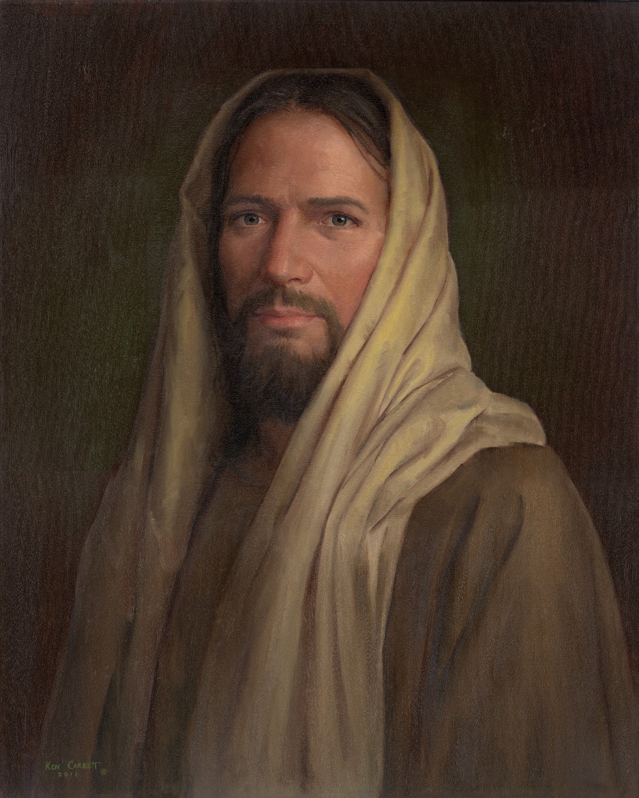


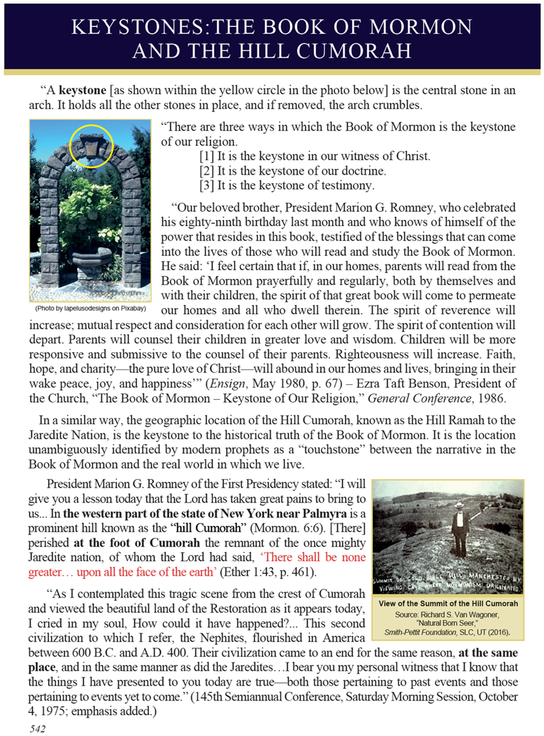
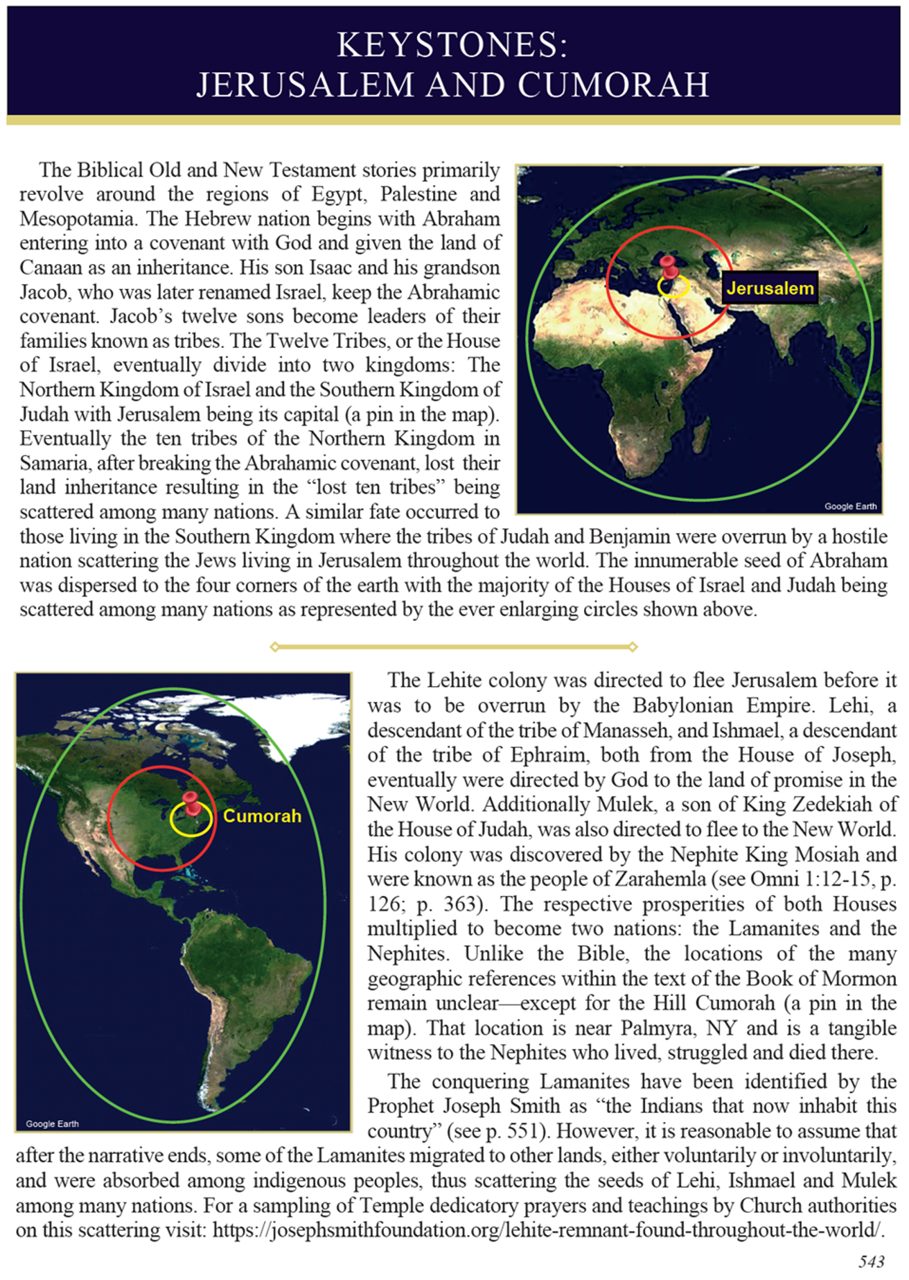


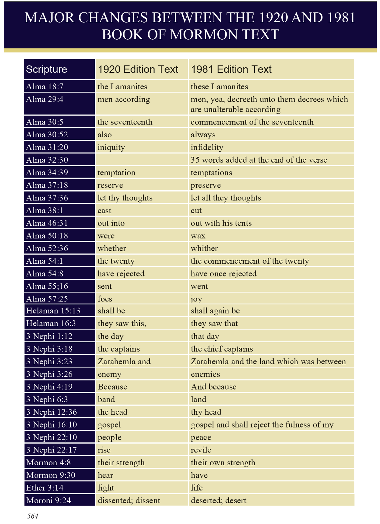


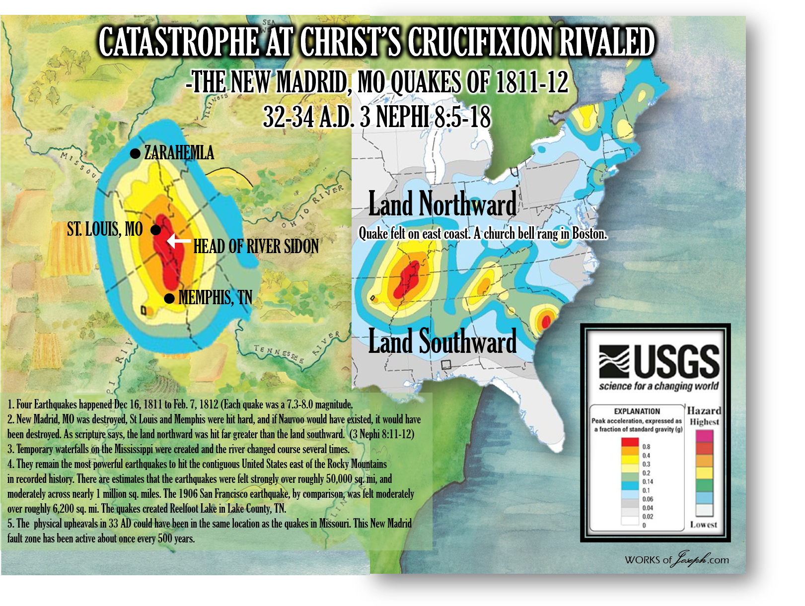


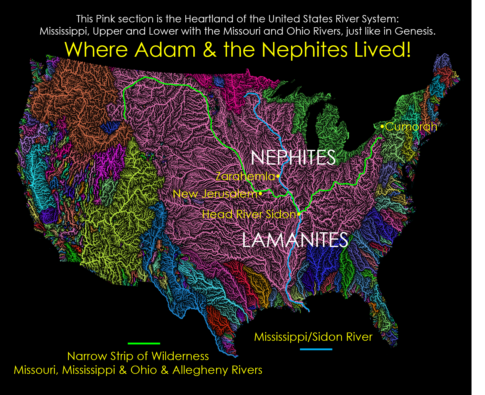


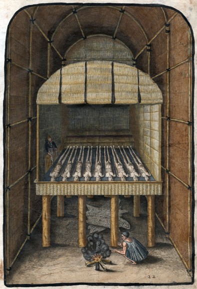

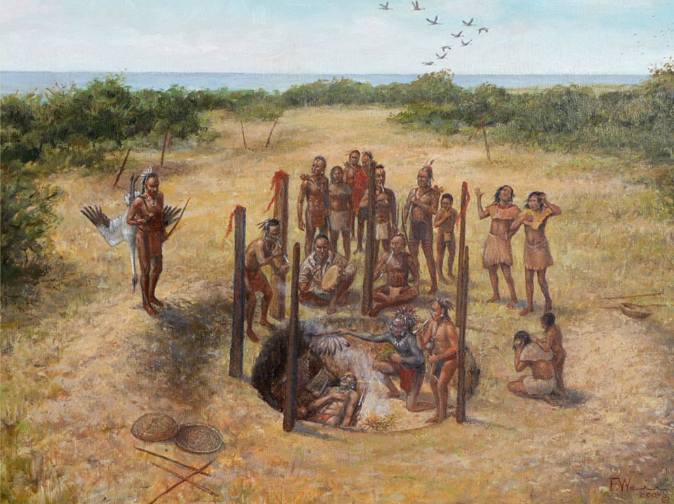
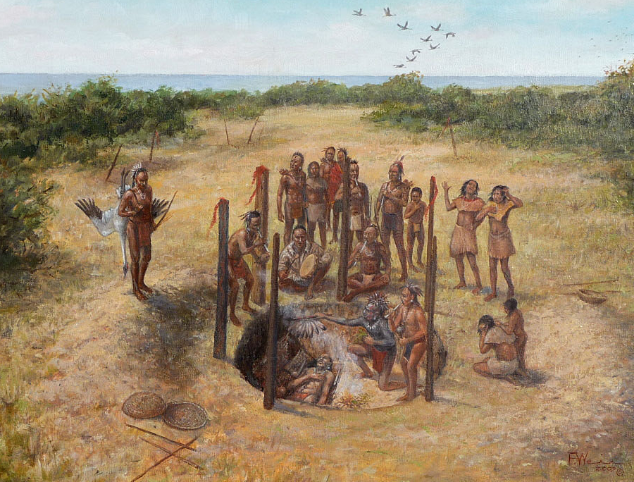
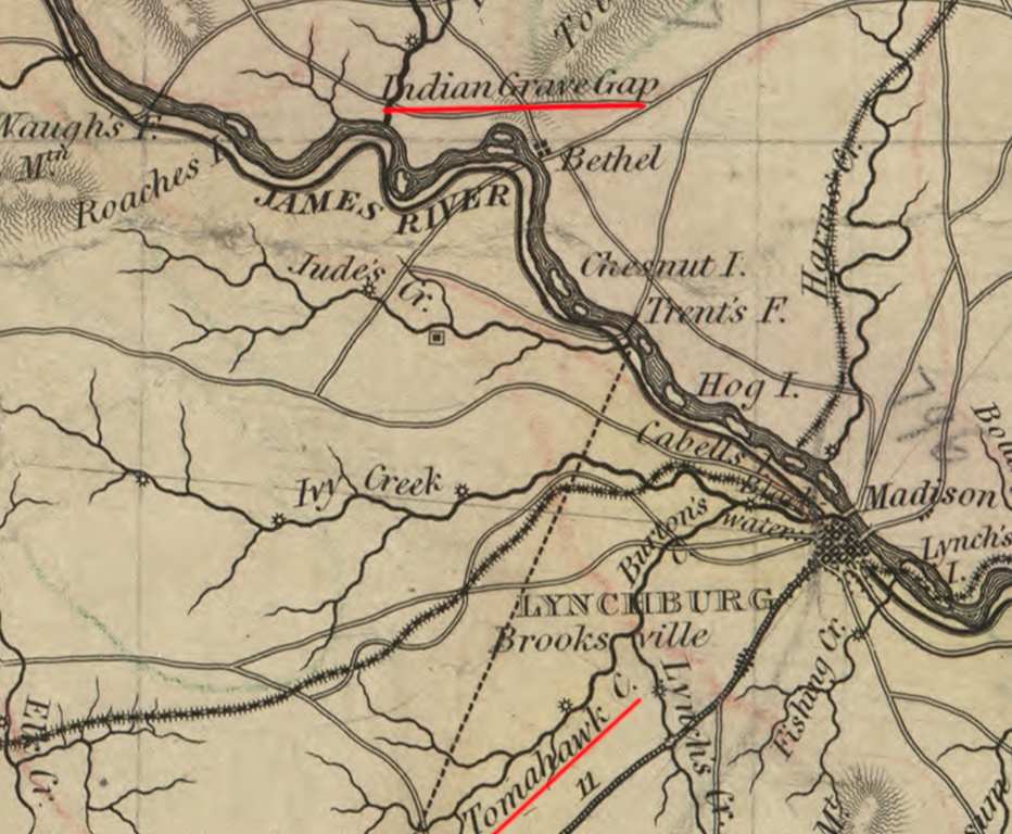
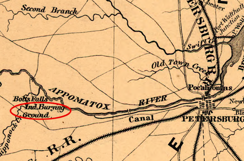

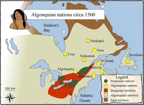

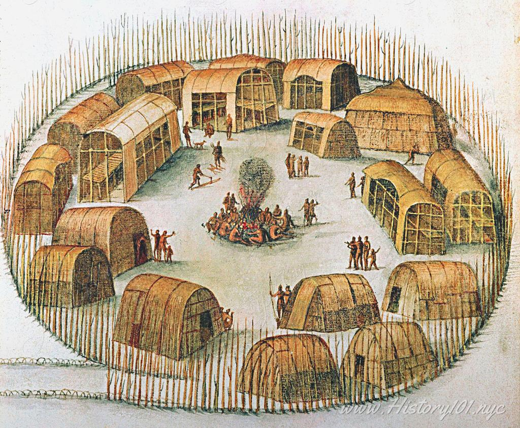
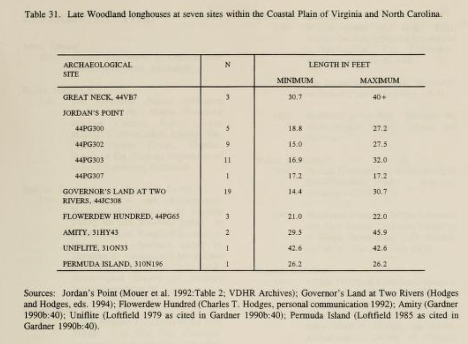 Many Native American burial sites were looted in raids by the first English colonists at Jamestown. Modern archeologists have identified a few burial sites, but nearly all places where Native Americans were buried have been covered over with farms, roads, and houses. There may be undisturbed grave sites underwater, covered as sea level has risen further after the Paleo-Indians first arrived.


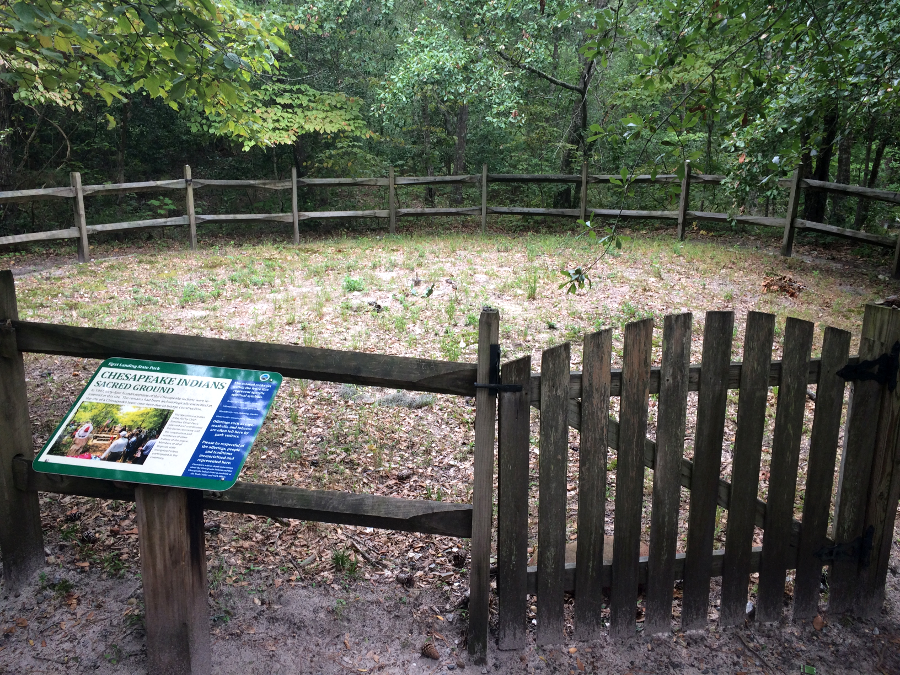
 64 members of the Chesapeake tribe were reburied at First Landing State Park in 1997


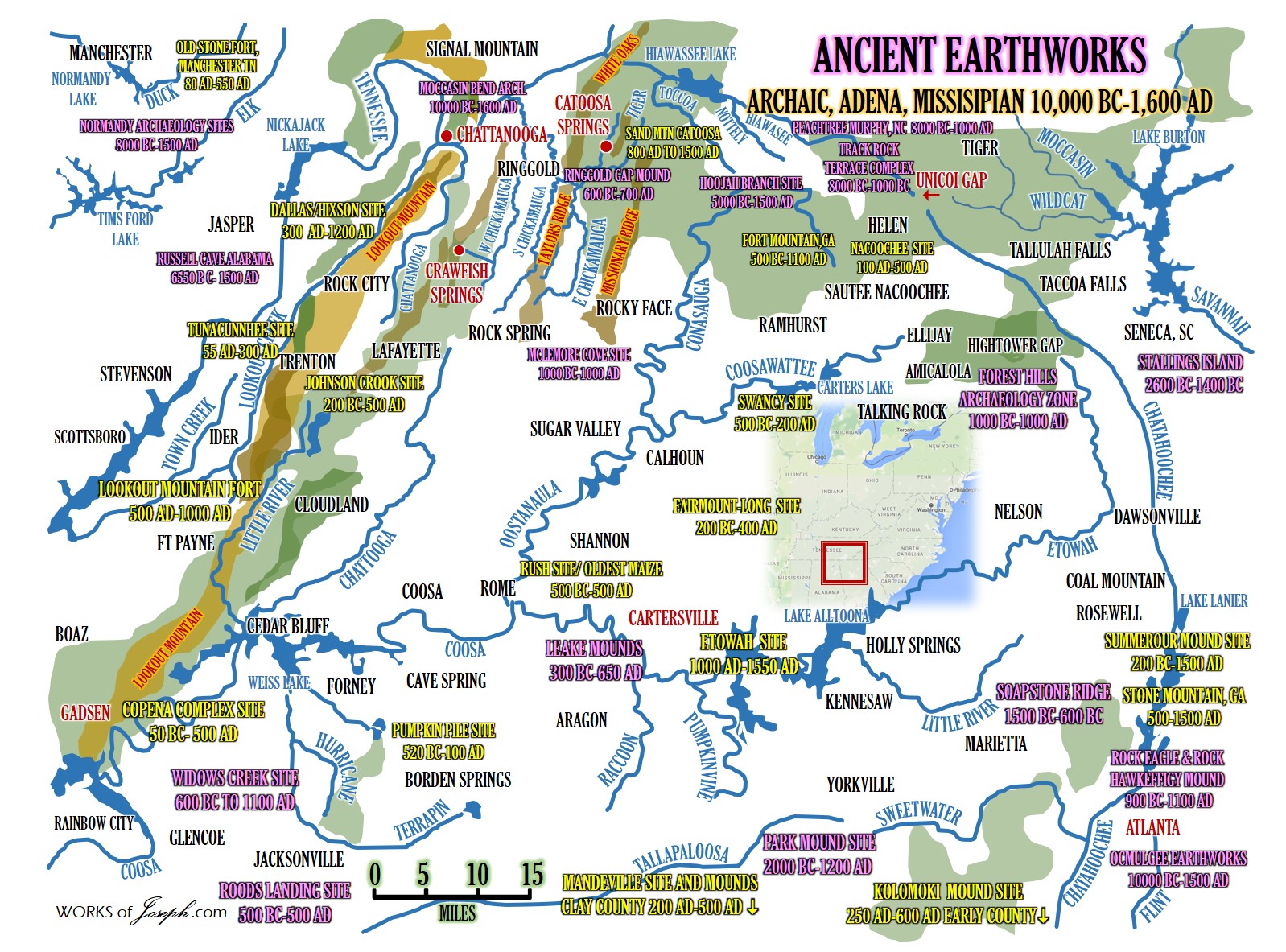


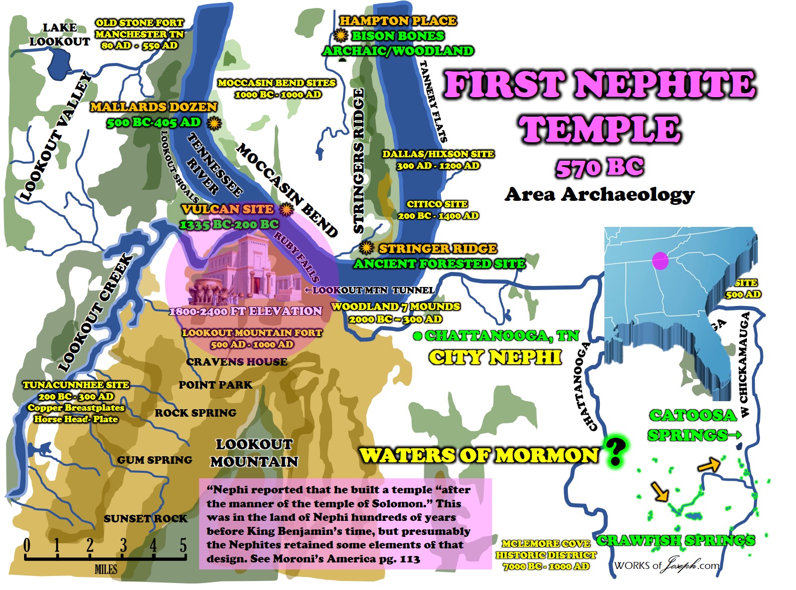


 In the First Chapter of Ether, Moroni is abridging the writings of Ether. What area or place is Moroni’s location, as he abridged these writings?


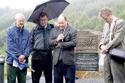


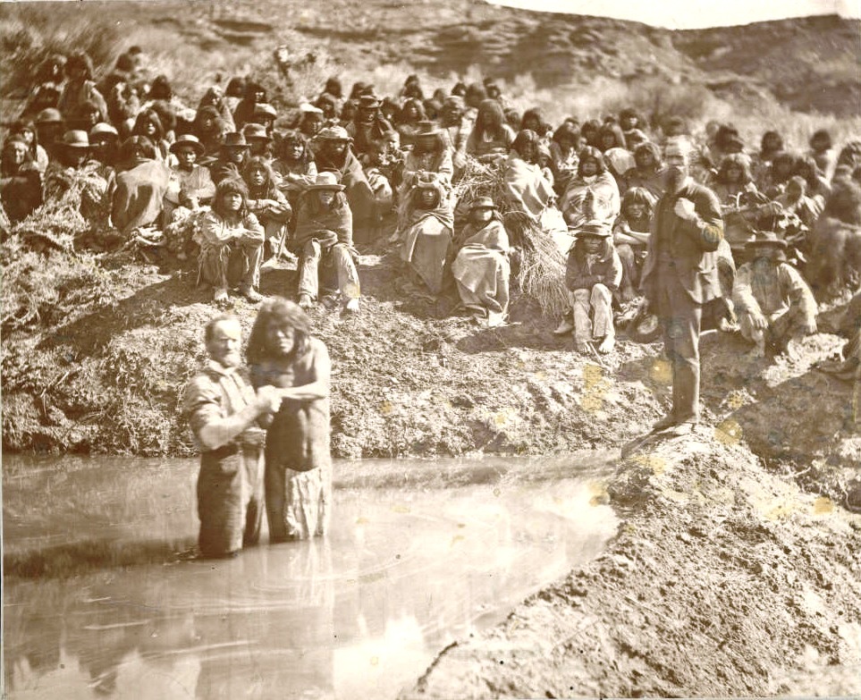


 The Indians, descendants of the Old Testament prophet Israel, would in
 Americans first hand. One of the most important of these encounters involved an Oneida Indian, who traveled several hundred miles to Illinois with his wife and daughter to visit the Mormons. The native styled himself as “an Interpreter of six tribes,” whom he confidently predicted would “receive the work.” He himself did, being “joyfully” baptized in May 1840. The unnamed Indian may have been Lewis Dana and his wife Mary Gont. During the next decade, the two were at the heart of the Mormons’ Lamanite effort.83
