
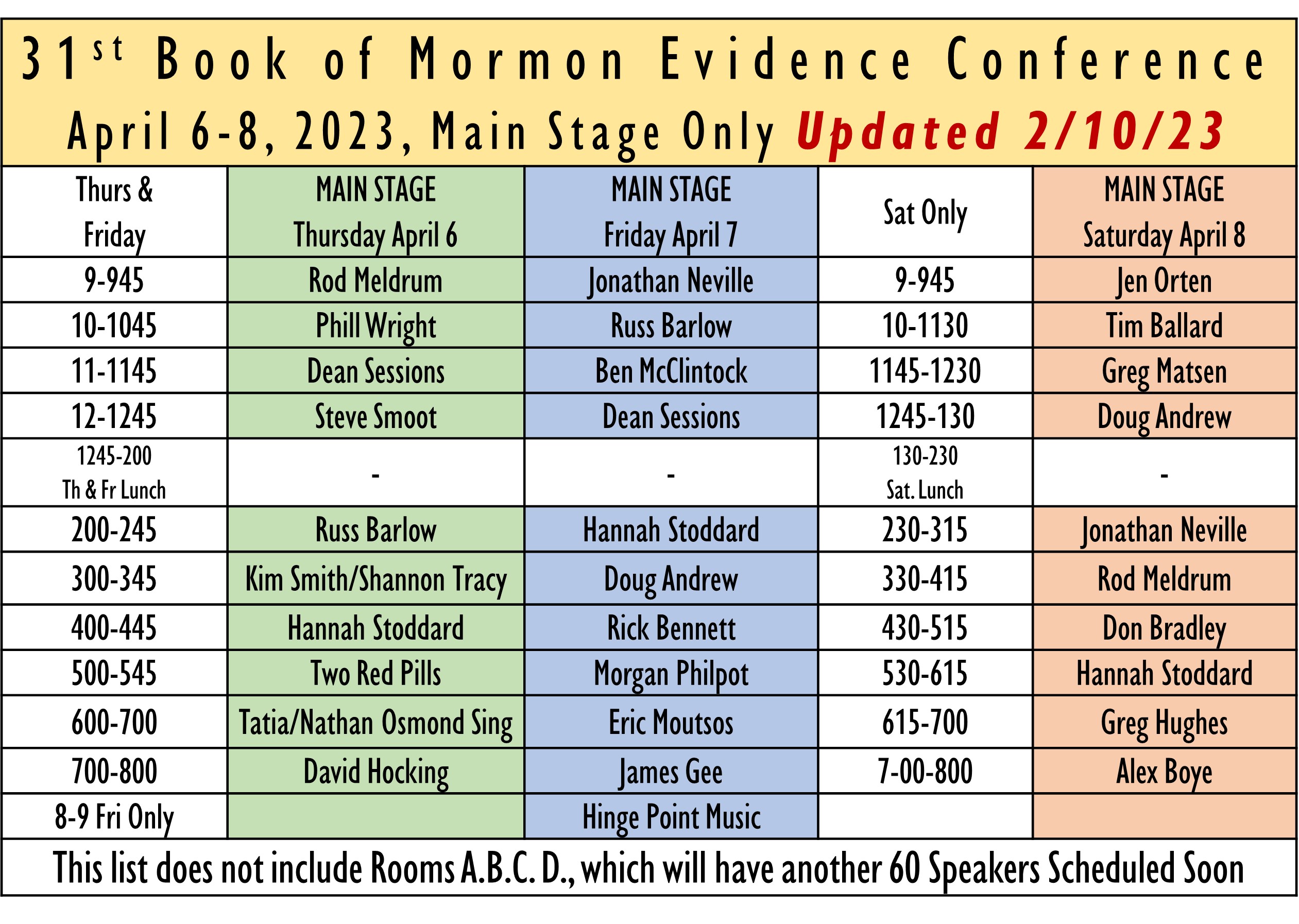
Mr. Gee has agreed to be one of the Keynote Speakers at our upcoming Firm Foundation Expo. This will be his first time speaking for us and he will share his archaeological insights about the Old Word and especially Nahom. See the main stage presenters below. In addition to these speakers we will have another 50 or more, and 125 presentations on April 6-8th in Sandy, UT. Join us. Information here:
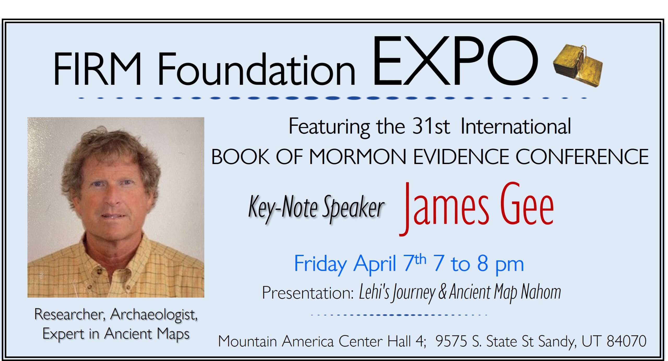
Jim Gee has been an independent guide, researcher, and archaeologist in the Middle East for over 20 years. In conjunction with a team from Brigham Young University, he has spent the past decade primarily in a series of tombs throughout Petra, uncovering many new discoveries of the ancient Nabataean culture. An expert in ancient maps and antiquities of the same region, Jim has written several articles published for the Neal A. Maxwell Institute at BYU. Through his work as a guide in Egypt, Jordan, Oman, Turkey, Israel and Palestine, Jim has developed many friendships throughout numerous communities and cultures, a highlight of his time spent in the Middle East.
Several maps from the seventeenth and eighteenth centuries support details of Lehi’s journey as recorded in the Book of Mormon. In 1751, the renowned cartographer Jean Baptiste Bourguignon D’Anville became the first to include Nahom (or Nehem), Ishmael’s burial place in the Book of Mormon, in his map of Asia. This map and a 1771 map of Yemen are the basis for most accurate maps of Arabia from 1751 to 1814. The spelling varies among the subsequent maps, with most using either D’Anville’s Nehem or Niebuhr’s Nehhm, but the location of Nahom does not differ between those maps that include Nahom. The mention of Nahom on the finest maps by the greatest cartographers of the times, in a location that corresponds to Lehi’s account, gives credence to Lehi’s travels.
James Gee- Journal of Book of Mormon Studies
“Until the last two hundred years or so, the hostile terrain of the Arabian Peninsula deterred explorers and cartographers from thoroughly investigating and recording the area on maps. Thus, Lehi—traveling the land around 600 b.c.—is not likely to have had a map of Arabia to which he could refer while journeying across the region. However, later travelers and explorers made maps that would support the details of his journey as they are recorded in the Book of Mormon.
In the August 1978 Ensign, Ross T. Christensen, professor of archaeology at BYU, was the first to suggest that Nephi’s Nahom might correspond to Nehhm on a 1771 map of Yemen. After reading Christensen’s article, I began a quest to find an original 1771 copperplate print of the map. It took me many years to find what I was seeking. In the end, I found not only the map Ross Christensen referenced but also many more maps which made mention of a place called Nahom.
Behind each of these maps lies the intricate story of its creation. Who contributed the information? Who outlined, engraved, or printed the map? Who published or sold it? Did the cartographer know more about Nahom than what is visible in his work? Some of these questions are unanswerable, but there is a certain amount of information that we can learn about the mapmakers. The 1771 map to which Ross Christensen referred was made by German-born Carsten Niebuhr, a member of the Danish expedition of 1761. His map was not, however, the first to make mention of Nahom. This honor belongs to a French cartographer named D’Anville.
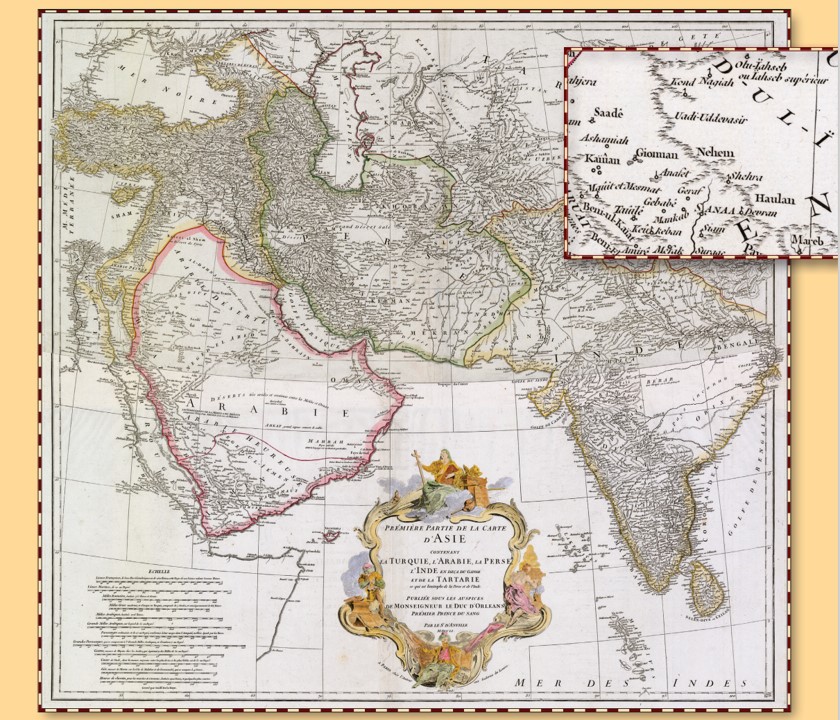
Jean Baptiste Bourguignon D’Anville was born in Paris on July 11, 1697. D’Anville was immersed in the study of geography at an early age, and he engraved his first map at the age of fifteen. D’Anville would become the greatest cartographer of his time.1 He was appointed geographer to the king of France in 1719. His maps were highly respected: The French navigator Bougainville used D’Anville charts when exploring the East Indies and
remarked on their accuracy and detail,2 and both Thomas Jefferson and Meriwether Lewis sought to obtain D’Anville maps prior to the Lewis and Clark expedition…
See 9 other maps here:
Gee continues, “Of course, not all maps of Arabia between the years 1751 and 1814 recorded the location of Nahom. In fact, it is generally found only on the finest and most expensive maps created by the best cartographers and published by the finest printers. In my searches I found countless maps of Arabia with no reference to Nahom or anything like it. Thus, it is somewhat amazing that the first modern map of the Arabian Peninsula, created by D’Anville in 1751, did record the location of this often ignored or unrecognized district. Furthermore, that same map inspired the Danes to send an expedition to the region to fill in the missing information, and the only survivor was the cartographer, Carsten Niebuhr. Not only did he engrave a place called Nahom on his map but he also gave us more details of the area in his journal. These two maps and the ones that followed all give testimony to Lehi’s epic journey almost two thousand years earlier.” Journal of Book of Mormon Studies Volume 17 Number 1 Article 6 2008 The Nahom Maps James Gee
Book of Mormon Visions Confirmed by Ancient Maps featuring Jim Gee
[…] place name Nahom persists after 2,600 years, 1 Nephi 16:34, pg 35 (See map […]
Comments are closed.