The painting below was created to show the plausibility of the First Nephite Temple built near Chattanooga, Tennessee. In several articles below in the year 1935, an ancient Egyptian Temple actually was found on the Clinch River between Chattanooga and Knoxville Tennessee.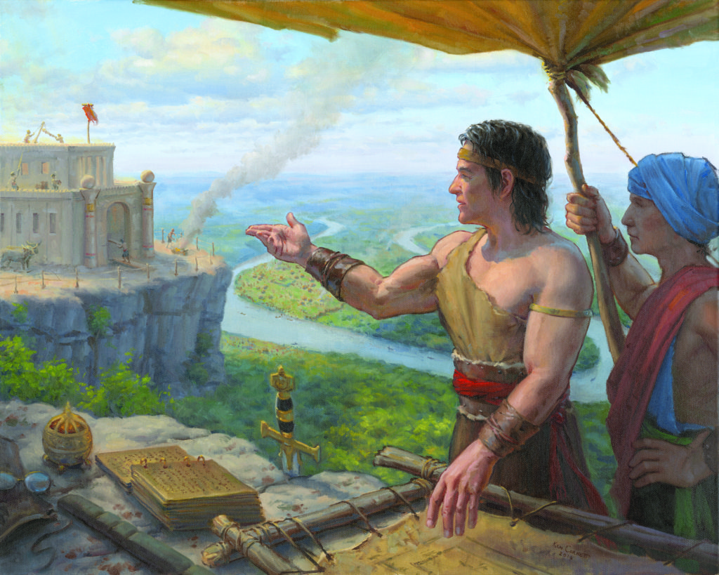
The tools of faith shown in this painting, were likely utilized by Nephi and subsequent Prophets, and delivered to Joseph Smith in our day. The Lord said through Joseph Smith, “Behold, I say unto you, that you must rely upon my word, which if you do with full purpose of heart, you shall have a view of the plates, and also of the breastplate, the sword of Laban, the Urim and Thummim, which were given to the brother of Jared upon the mount, when he talked with the Lord face to face, and the miraculous directors which were given to Lehi while in the wilderness, on the borders of the Red Sea. And it is by your faith that you shall obtain a view of them, even by that faith which was had by the prophets of old.” D&C 17:1,2
Nephi’s breastplate in the painting represents Nephi’s readiness for the protection of his people and was not necessarily the one that Joseph Smith found at Cumorah. The breastplate at Cumorah was possibly one of those mentioned in Mosiah 8:10, given to Mosiah by Limhi’s explorers. This Jaredite breastplate was handed down to Alma (Mosiah 28:20), and eventually to Moroni to be buried with the other tools of faith at Cumorah. Mosiah (the second) used seer stones or interpreters, to translate the twenty-four Jaredite plates (Mosiah 28:13), as his grandfather Mosiah (the first) interpreted the Jaredite stone record (Omni 1:20). These seer stones are represented in the painting and may have been handed down from Lehi or Nephi. Moses and the Israelites were also blessed with similar tools of faith that physically represented spiritual things. “…The ark of the covenant overlaid roundabout with gold, wherein was the golden pot that had manna, and Aaron’s rod that budded, and the tables of the covenant; And over it the cherubims of glory shadowing the mercy seat; of which we cannot now speak particularly.” Hebrews 9:4-5.
After Nephi and his people were driven into the wilderness (likely to Georgia and Tennessee up the Chattahoochee River) and found a place to settle, Nephi continued to instruct and serve his people. “And I did teach my people to build buildings, and to work in all manner of wood, and of iron, and of copper, and of brass, and of steel, and of gold, and of silver, and of precious ores, which were in great abundance. And I, Nephi, did build a temple; and I did construct it after the manner of the temple of Solomon save it were not built of many precious things; for they were not to be found upon the land, wherefore, it could not be built like unto Solomon’s temple. But the manner of the construction was like unto the temple of Solomon; and the workmanship thereof was exceedingly fine.” 2 Nephi 5:15-16

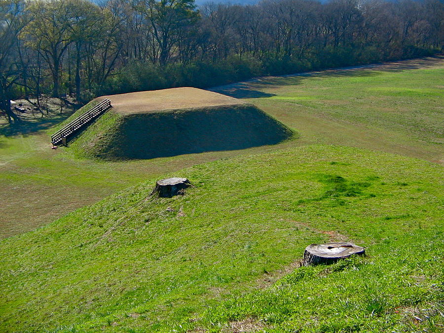
Leake Mounds Georgia
Hopewell Culture 300 BC to 650 AD
What is the Leake site and why is it significant?
Beginning around 300 B.C., local people began to live at the Leake site, similar to the numerous other villages that dotted the Etowah Valley at this time. During the next few centuries, the construction of the monumental earthworks began. In particular, we know that the early stages of Mound B and at least a portion of the ditch was constructed. It appears that the ditch was an old channel of the Etowah River that was modified by the occupants. While most of the pottery and other remains from the early occupation represent local products, the minority presence of non-local items indicates that peoples from other parts of the Eastern U.S. were visiting the site and/or that locals were bringing back foreign materials from their journeys. We have identified pottery from the Gulf Coast and northern Mississippi/Alabama, while a small fragment of copper may derive from the Great Lakes region. These materials were recovered from an area near Mound B that is indicative of group/communal activities. Such activities appear to have been focused around the construction of the earthworks and the rituals associated with this. Source
Leake Mounds (9BR2) is an important archaeological site in Bartow County, Georgia built and used by peoples of the Swift Creek Culture. The site is 2 miles (3.2 km) west of the well-known Etowah Mounds on the Etowah River. It predates that site by hundreds of years.
Excavation of nearly 50,000 square feet (4,600 m2) on the site showed that Leake Mounds was one of the most important Middle Woodland period site in this area from around 300 BCE to 650 CE. It was a center with ties throughout the Southeast and Midwest. It was abandoned about 650 CE. It was not occupied again for nearly nine hundred years, until about 1500, by different peoples near the end of the Mississippian culture period.
The site includes at least three major platform mounds and a large semi-circular moat/ditch. While much of the mounds were razed to be used as road fill for the expansion of the Georgia State Route 113 and Georgia State Route 61 in the 1940s, significant portions of the site remain. Several sites on nearby Ladds Mountain were integrally associated with Leake, including Shaw Mound, a stone burial mound; Indian Fort, a stone wall enclosure; and Ladds Cave, a large cave.
Examples of a type of pottery decoration consisting of a diamond-shaped checks found at Leake Mounds are also known from Hopewell sites in Ohio (such as Seip, Rockhold, Harness, and Turner), the Mann Site in southern Indiana. This style has also been found on pottery at other sites in the South, such as the Miner’s Creek site, 9HY98, and Mandeville Site in Georgia, and the Yearwood site in southern Tennessee.
Etowah Indian Mounds in Georgia
Mississippian or Fort Ancient Culture 1000-1550 with Pottery 200 BC to 600 AD
The Etowah Indian Mounds are located just 78 miles south of Crawfish Springs, GA where we believe may be the Waters of Mormon as describes in the Book of Mormon.
When visiting the Etowah Mounds, guests can view the “borrow pits” (which archaeologists at one time thought were moats), where workers dug earth to construct the three large mounds in the center of the park.
Etowah Indian Mounds (9BR1) are a 54-acre (220,000 m2) archaeological site in Bartow County, Georgia, south of Cartersville. Built and occupied in three phases, from 1000–1550 AD, the prehistoric site is located on the north shore of the Etowah River… Older pottery found on the site suggest that there was an earlier village (ca. 200 BC–600 AD) associated with the Swift Creek culture. This earlier Middle Woodland period occupation at Etowah may have been related to the major Swift Creek center of Leake Mounds, approximately two miles downstream (west) of Etowah…
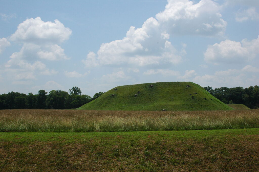
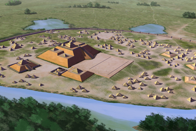
Etowah has three main platform mounds and three lesser mounds. The Temple Mound, Mound A, is 63 feet (19 m) high, taller than a six-story building, and covers 3 acres (12,000 m2) at its base. In 2005-2008 ground mapping with magnetometers revealed new information and data, showing that the site was much more complex than had previously been believed. The study team has identified a total of 140 buildings on the site.” Source
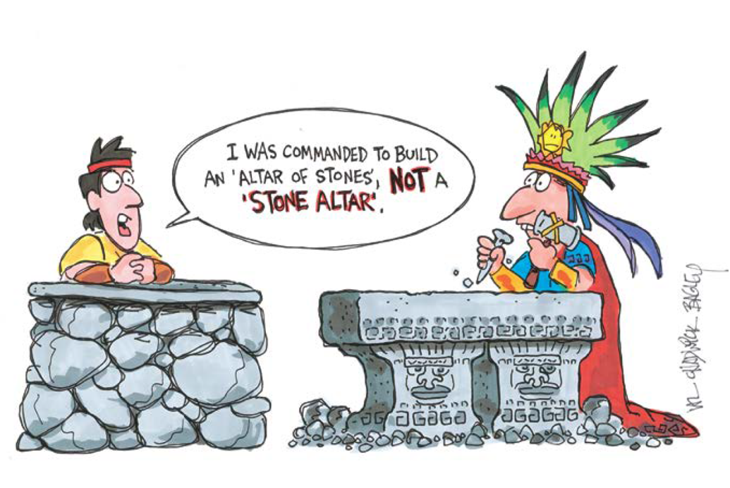
Nephites built mainly of wood, and earth as you can see quotes below. At times they waited for trees to grow up and they used cement. Cement is not stone. There is no indication of building with large cut stone as shown in Central America. Hewn or cut stone would be against the Law of Moses. Only one place mentions stone in the Book of Mormon and it says, “Yea, he had been strengthening the armies of the Nephites, and erecting small forts, or places of resort; throwing up banks of earth round about to enclose his armies, and also building walls of stone to encircle them about, round about their cities and the borders of their lands; yea, all round about the land. ” Alma 48:8 Notice it says “walls of stone” not “stone walls” as compared in the cartoon here by Val Chadwick Bagley:
Heleman 3:11 “And thus they did enable the people in the land northward that they might build many cities, both of wood and of cement.”
Jarom 1:8 “And we multiplied exceedingly, and spread upon the face of the land, and became exceedingly rich in gold, and in silver, and in precious things, and in fine workmanship of wood, in buildings, and in machinery, and also in iron and copper, and brass and steel, making all manner of tools of every kind to till the ground, and weapons of war—yea, the sharp pointed arrow, and the quiver, and the dart, and the javelin, and all preparations for war.”
Mosiah 11:8 “And it came to pass that king Noah built many elegant and spacious buildings; and he ornamented them with fine work of wood, and of all manner of precious things, of gold, and of silver, and of iron, and of brass, and of ziff, and of copper;
9 And he also built him a spacious palace, and a throne in the midst thereof, all of which was of fine wood and was ornamented with gold and silver and with precious things.
10 And he also caused that his workmen should work all manner of fine work within the walls of the temple, of fine wood, and of copper, and of brass.”
See more about stone walls and buildings here: https://bookofmormonevidence.org/stonehenge-of-north-america-walls-of-stone/
More about building with earth and wood here: https://bookofmormonevidence.org/buildings-hidden-cities-great-hopewell-road-graded-ways/
 150 North American Maps
How Many Mounds Exist in North America?
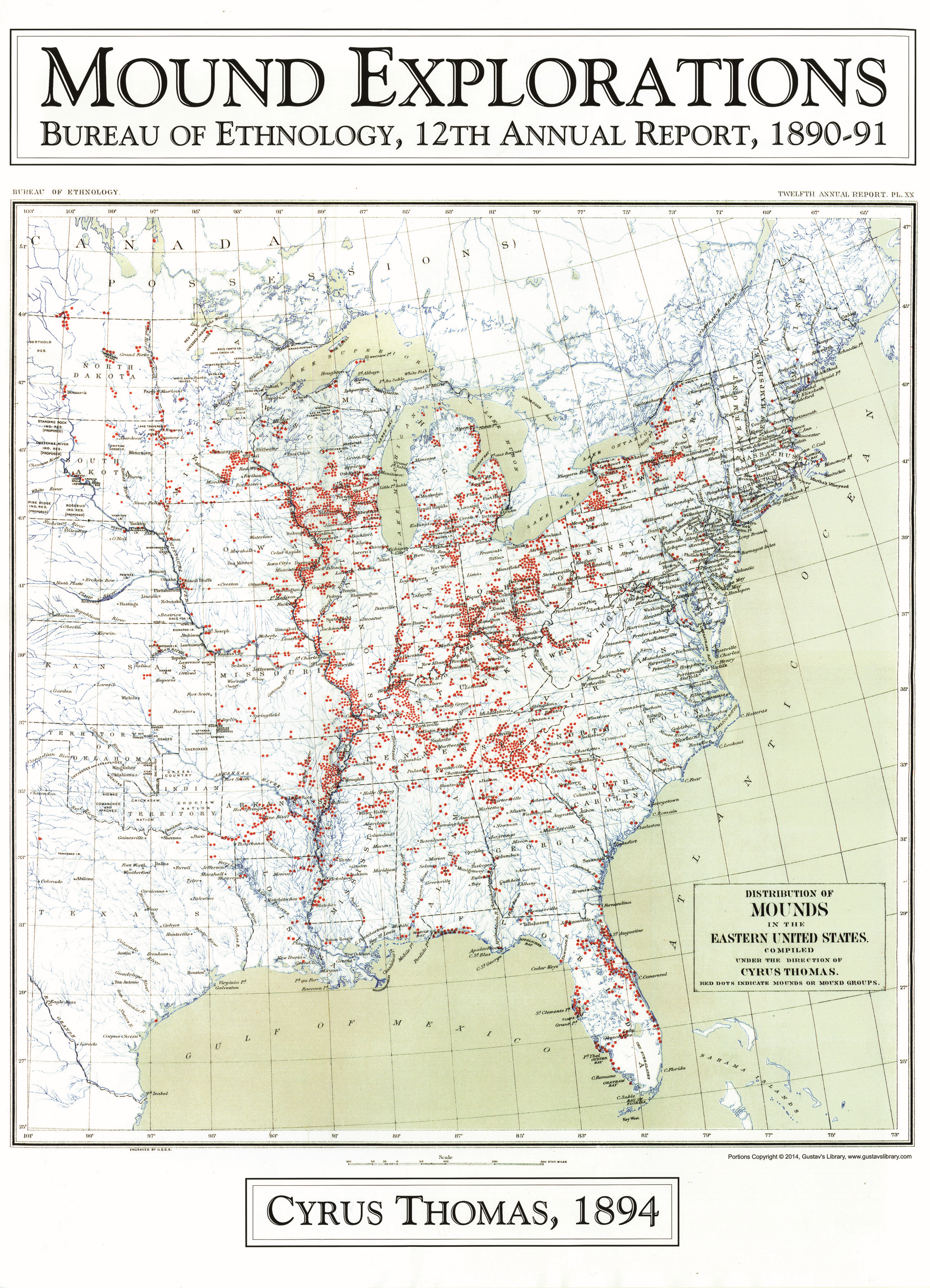
The most common question that is asked about mounds is, “How many exist?” In the 1800’s the Smithsonian sponsored many expeditions to identify mound sites across America. A map (shown below) was produced by Cyrus Thomas in 1894 [Map Below] in a Bureau of Ethnology book. They found approximately 100,000 mound sites, many with complexes containing 2 to 100 mounds. The figure of 100,000 mounds once existing— based on Cyrus Thomas map revealing 100,000 sites—is often cited by others, but that estimate is far, far too low. After visiting several thousand mounds and reviewing the literature, I am fairly certain that over 1,000,000 mounds once existed and that perhaps 100,000 still exist. Oddly, some new mound sites are discovered each year by archaeological surveys in remote areas. But in truth, a large majority of America’s mounds have been completely destroyed by farming, construction, looting, and deliberate total excavations” – Gregory L. Little, Ed.D., The Illustrated Encyclopedia of Native American Mounds & Earthworks, Eagle Wing Books, Inc., Memphis, TN [2009].
Secrets About ‘Tennessee’s Ancient Egyptian Temple’ Revealed
Dr. Greg Little – AncientPages.com – The background of Tennessee’s ancient “Egyptian Temple” is not a great secret. But it appears to remain enigmatic to many who are interested in alternative archaeology as well as proof to others that ancient America was visited in ancient times by people from the Middle East.
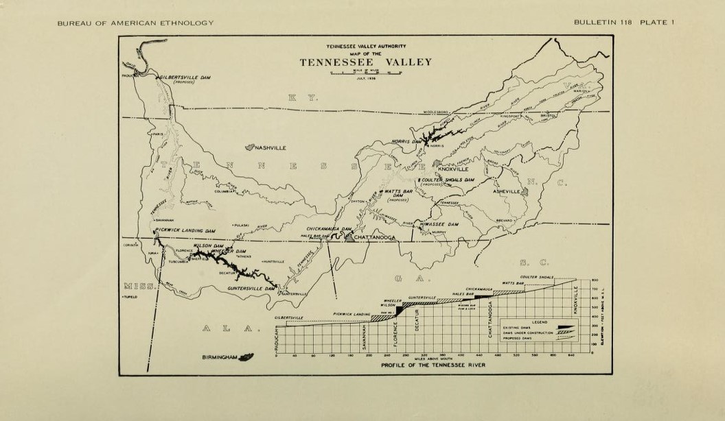
SMITHSONIAN INSTITUTION BUREAU OF AMERICAN ETHNOLOGY BULLETIN 118
AN ARCHAEOLOGICAL SURVEY OF THE NORRIS BASIN IN EASTERN TENNESSEE
by WILLIAM S. WEBB
I do believe that ancient America was populated by an astonishing blend of people migrating from many parts of the world over many thousands of years. And it’s possible that some ancient Egyptians made it to America.
I’m sure archaeologists will scoff at that idea, but all I’m saying is that it is possible. But the assertion that this particular site was “Egyptian” is a stretch—a long, long stretch based on just about nothing whatsoever.
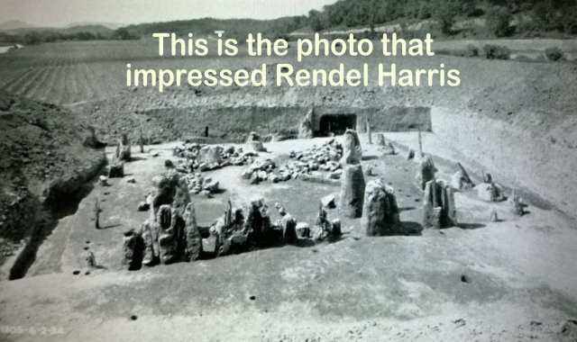
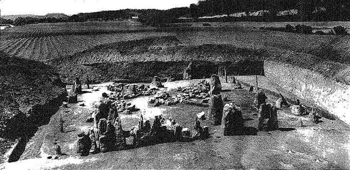
The Egyptian Temple assertion was made solely on the speculations of a respected British manuscript curator after he saw a photo of the excavated mound in the “New York Times” in 1934.
In 1935 he published a brief article about it entitled, “A Temple in Tennessee,” as part of essays he routinely issued.
Much earlier in his life Harris had become convinced that Egyptians visited America well before Columbus. He thought that they initially visited the Bahamas and eventually moved into the Gulf of Mexico and up the Mississippi.
He also speculated that Egyptian traders took copper from the Americas back to the Mediterranean and that they established a large colony in East Tennessee.
The excavation of a building structure under a mound in Tennessee—and the photo from the excavation—was enough to convince him he was correct.
When the photo was published, Harris saw what looked like standing stones forming the perimeter of a square building.
It had been excavated from under what is assumed to be a Hopewell-era mound, but it’s more likely it was Mississippian. There were two large “standing stones” next to each other Harris interpreted as pylons, which was a common feature in Egyptian temples.
That, in essence, is the story of how Tennessee’s Egyptian temple came to be. Over time it has been embellished, altered, and made increasingly mysterious.
It is cited as evidence of a cover-up of ancient Egyptians in America by Tennessee Valley Authority “Irrigationists”!!??
Indeed, the mound sites involved have been covered by water but I’m utterly clueless why anyone would have applied the term “irrigationists.”
In September 2007 an article in “Ancient American” retraced the basics of the story and brought it back to life. However, various internet sources assert that the excavation of the mound was halted when the Egyptian temple was found and that Harris, described as an archaeologist specializing in Egyptian sites, was called in to finish the work.
It is also widely asserted that here were two huge standing stones forming an entranceway into this “temple” and that the walls of the building were stone.
None of this is true, but the story is intriguing. Other internet sources claim that many of the excavated sites near the temple had large standing stones, many in straight rows, associated with them. That is true, depending on what “large” means.
The TVA Mound Excavations—1933-1934
In December 1933 the Tennessee Valley Authority (TVA) convened a conference in Knoxville, TN with several university representatives and other governmental agencies for the purpose of planning a survey of Native American sites that were to be inundated after the Norris Dam was completed.
The dam on the Clinch River was to be the first hydroelectric dam for the TVA. By August 1933 the survey project was planned and the survey and large excavations were conducted by the Civil Works Administration and later through Federal Emergency Relief Administration funds. The project was done by late 1934. The TVA’s supervising archaeologist was William S. Webb. Webb was then the Chairman of the University of Kentucky’s Department of Anthropology and Archaeology and also the Chairman of the university’s Physics Department. All of the actual excavation work was carried out primarily by students who were guided by a host of supervisors.
The project identified 23 sites in the area that soon became the bottom of a series of lakes created by the dam. There were 29 mounds at the sites: 20 earth mounds, 9 stone mounds, and several village areas. Twelve of the mounds were found to be burial mounds and 17 had prehistoric structures associated with them. A total of 54 wooden structures were identified. The subsequent report on the project related that all of important sites were excavated and all of the artifacts and other archaeologically important materials were preserved. The full report was published by the Smithsonian as “Ethnology Bulletin 118” and was written by Webb. The report contains dozens of intriguing photos of the mounds, excavations, artifacts, and skeletal remains.
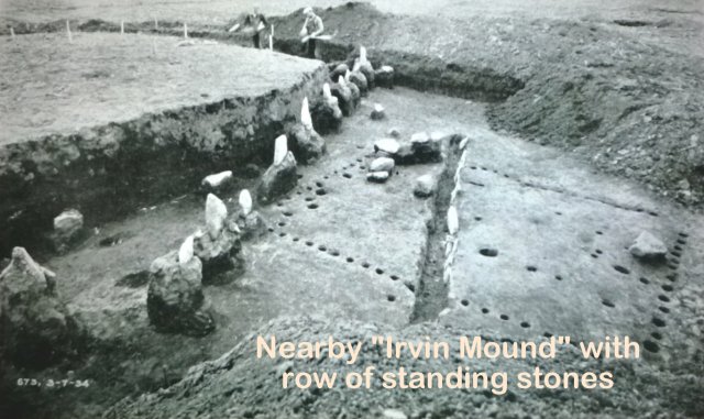
One mound, the “Irvin Mound,” had a row of 10 standing stones, most of which were about 2-4 feet in height. Adjacent to the line of standing stones was the remains of a rectangular building formed by cedar posts. Inside this rectangular building was another line of small standing stones.
Oddly, a copper coin, button, and bead were found at a depth of 18 inches inside another structure under a smaller adjacent mound.
The coin was identified as a 1787 coin minted by New Jersey. Still another line of 10 standing stones was found at an adjacent structure uncovered at the same site.
It is Plate 108 in the Smithsonian Bulletin. When the Cox Mound was excavated, a series of structures was found to have been built progressively, one of top of another, forming an 8-foot high mound. A total of 49 burials were uncovered during the excavation of the mound.
The photograph (Plate 108 shown at the top of this article) shows the floor of the mound. The nearly square building (that had originally been constructed before the mound was formed over it) was 37.5 feet by 36.5 feet.
The outer walls were formed by upright red cedar posts about 14 inches in diameter embedded from 4 to 30 inches into the soil. This structure had a roof covered with sod. At some point the sod roof collapsed and another structure was built on top of it.
The second structure eventually collapsed and a third structure was erected on the top of the earlier two buildings. However, some of the cedar posts from the original building remained in place and they appear to have been incorporated into the later structures.
When the excavation was done in 1934, the excavators carefully dug around the remaining cedar posts leaving numerous irregularly shaped vertical “cylinders” which appear, at first glance, to be standing stones. Two of these posts were 72 and 82 inches tall, the tallest at the site. The remains of the cedar posts were treated with a liquid that hardened the rotted wood, and the dirt surrounding the cedar posts was later removed.
Inside the building the excavators found 72 limestone and sandstone blocks scattered around. Another pile of 200 “irregular rocks” was found in a different area of the building. These can be seen on the photo at the top of this page and were the only rocks found in this excavated structure.
While standing stones were found at other mounds, strangely, none of the features shown in the photo that so impressed Harris were actually standing stones.
All of the vertical features shown in this mound were the remains of excavated cedar posts. A careful review of the pottery and other artifacts found during the excavation are typical Native American objects characteristic of Mississippian villages active in that region in the 1200’s to historic times.
All of the sites that were excavated by the TVA project have now been underwater nearly 80 years.
Out of my own curiosity, all of the measurements of skeletal remains found during the TVA were examined in the Bulletin report.
Several hundred skeletal remains were found during the TVA’s excavations and measurements were made on every bone and skull found.
About 100 skeletons were sufficiently intact to make good measurements. The most consistent measurement of bones was the femur and as a guideline I used the usual estimation formula (2.32 x femur in cm + 65.53 cm). Using this formula, the tallest skeleton found would have been just under 5 feet 10 inches in height. The average size of male skeletons was about 5’ 6”.
In 1950 Webb was involved in the excavation of the Dover Mound in Kentucky. A total of 55 burials were found in the mound, but in a log-lined tomb at the base of the mound, a skeleton 7-feet tall was found. I have no reason to suspect that Webb underreported the size of the skeletons.
In fact, it seems apparent that if he had found unusually tall skeletons, he would have reported them and I also believe that if he had found Egyptian artifacts, he would have reported those as well.”
Written by Dr. Greg Little – AncientPages.com Contributor
About the author – Dr. Greg Little – is author or co-author of nearly 50 books and over a thousand articles. He is part Seneca and is author of The Archetype Experience, People of the Web, and Grand Illusions as well as several other books on ancient history. He has also published numerous articles on America’s mound builder culture and specific mound sites. He has been featured in documentaries on The History Channel, Discovery, The Learning Channel, National Geographic Channel, MSNBC, and SciFi.
For more information visit AP Magazine
Copyright © Dr. Greg Little – AncientPages.com Contributor – All rights reserved
How Manifest Destiny Destroyed Book of Mormon Evidence
January 12, 2015 by JA Benson
I know! Amazing! An Egyptian temple in East Tennessee of all places, AND why is this fact not widely known??!! I’ll tell you why, Dear Reader, our ignorance of the Egyptian temple ruins in East Tennessee is the consequence of Manifest Destiny.
When European colonists settled North America they found immense earth mounds and earthwork enclosures, larger than Giza in Egypt. Manifest Destiny and all that, it seemed prudent to plow it all under. The vanquished Native inhabitants were deemed ignorant savages. In regards to the Native Americans, consequentialism was the morality of the day, in other words “the ends justify the means”.


“The geography of the Book of Mormon has been a complex issue with multiple factors involved. For example, when the book was first published, it was commonly thought that Native American Indians had never achieved the level of “civilization” as defined in the book Ancient Society by Lewis Henry Morgan which had become the handbook of instruction for the US government in dealing with the Indians. Morgan proposed that all human societies evolve through three stages of development, from being ignorant savages (a term he then used to label the Native Americans) to barbarism and finally on towards civilization. John Wesley Powell, Ephraim George Squier and Morgan were three highly influential men in science, politics and Native American affairs, governing such organizations as the AAAS (American Association for Advancement of Science), the Bureau of Ethnology, the Smithsonian Institution, the Bureau of Indian Affairs and were very active politically. Both Powell and Squier’s fathers happened to be Methodist ministers in Palmyra New York in the 1820’s when the Book of Mormon was first published and these men began what non-Mormon scholars have called the “wanton destruction” of the ancient history of the Mound Builder civilization.” -Rod L. Meldrum
Over parts of the eastern half of the United States, farmers put their plows to what they wanted to believe was virgin turf. They uncovered arrowheads by the bucketfuls, clay pots, long metal “knives” and occasional stone boxes with the bones of the dead. Thousands of mounds and earthwork stockades were leveled with shovels. Native American pottery, and other artifacts, and even the bones themselves sometimes made it into private collections. For the most part the metal was melted down and recycled. For a time, bones were ground up into fertilizer, and the unwanted artifacts were thrown into trash piles. European civilization was the victor, and it was in the best interest to promote a Anglo-Saxon version of history. As the immense earthworks were leveled, the North American Native population was completely conquered by wiping away the history and accomplishments of the ancient inhabitants.
Least we frown and waggle our forefingers at our European ancestors with our modern 21st century morality; this conquering business was nothing new to humanity. One group of humans subduing another group of humans seems to me pretty typical human behavior. Conquerors all over the world, throughout recorded history, and across all civilizations, have made it part of their conquering to erase the traces of the previous dynasties.

Battle of Franklin
A perfect example of what occurred in the eastern US, both north and south and including the mid-west, happened where I live. Just south of the town of Franklin Tennessee, on the southern edge of the Eastern flank of the Battle of Franklin where the Army of the Ohio soundly beat the Army of Tennessee on that fateful afternoon of November 30, 1864, is a completely demolished Hopewell Mound Site of the Mississippian period (900-1450AD) identified as the DeGraffenreid Site.
Our house sits on the edge of a ridge just a few yards from a large bend in the Harpeth River, right outside of the approximately 20 acre DeGraffenreid Site in a quiet middle-class subdivision of modest red brick homes. Most people would never guess the rich and varied history of land which has been inhabited by humankind for at least a thousand years. I, in fact did not know about the DeGraffenreid site literally right under us, until very recently, and we have lived here for 22 years.

To give you a little history lesson, Dear Reader, the first known inhabitants of our little piece of heaven were the Hopewell Natives of the Mississippian period. Later American settlers, most notably a family of moonshiners who spanned several generations, before, during and after the Civil War, who proudly claimed to be the “biggest moonshining outfit in the county” lived on our property situated between a narrow neck of land between the 20 acre DeGraffenreid site and 5 Mile Creek which empties into the Harpeth River. The moonshiners were shut down in the 1930’s by a no-nonsense county sheriff who filled the family car with bullet holes and threatened to do the same to the family if they didn’t cease and desist with the illegal distillery. During the Civil War, several skirmishes happened nearby and a Confederate Calvary regiment commanded by Major General Nathan Bedford Forrest camped on our property after the Battle of Franklin.
The DeGraffenreid mounds, one large and eight significantly smaller, were enclosed by an immense stockade. Farmers in the 1800’s greatly damaged the site by leveling the mounds and the stockade. Amateur archeologists shortly after the Civil War carted off some of the artifacts. At the turn of the last century, an early Monsanto company mined the area for phosphate, so by 1919 all traces of the mounds were gone.
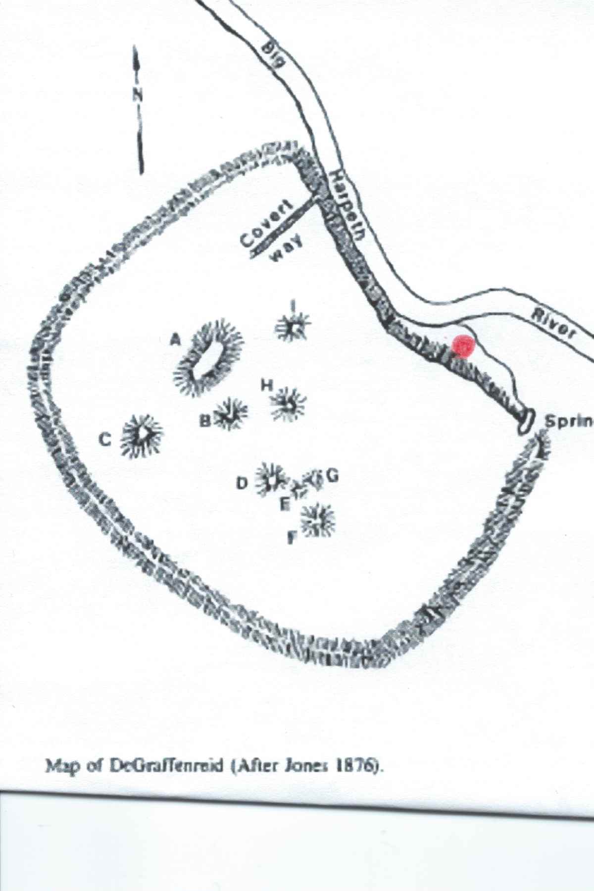
Red dot is where the Benson homestead is probably located
After extensive damage was done, during the late 1960’s, we can thank University of Tennessee-Knoxville archeologist H.C. (Buddy) Brehm who visited the site and conducted a meager salvage of the remaining items and more importantly provided documentation of the DeGraffenreid site. Without Mr Brehm we would know, even less, of the DeGraffenreid site. Unfortunately where these relics are today, cannot be determined. An interesting bit of information from burial mound H1:
“four copper crosses (copper plates embossed with a copper cross design)”. From Potash From Pyramids: Reconstructing Degraffenreid (40WM4)–A MIssissippian Mound Complex in Williamson County Tennessee
I did a little digging to find out more about Buddy Brehm and I came across this forehead slapping tidbit:
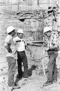
SIAS members Bob Ferguson (center) and Buddy Brehm (right) discussing the sabertooth cat find with an unidentified worker, summer 1971. Photo courtesy of Les Leverett.
“During this time there was not a State Archaeologist or antiquities laws in Tennessee, nor were there any universities interested in the archaeology of the region. State laws did not yet protect prehistoric human remains, and when an ancient graveyard was encountered during development, the graves were open to whoever wanted to dig them. My memories from that time include seeing Boy Scout troops digging graves to earn their “Indian Lore” badges, and housewives digging with their kitchen utensils. SIAS members were also present on these sites, though with the intention of recording as much information as possible before graves were bulldozed away. ” John T Dowd
If this all weren’t so tragic, it would be really hilarious in a Keystone Cops kinda way. Think about it, Dear Reader, if this chunk of tantalizing history could exist unknown to me, a person who loves history, right under my nose for two decades….
This brings us to Wayne May and Rod Meldrum. Neither of these gentlemen hold degrees in history or archeology, but instead are Book Of Mormon enthusiasts who are able to think outside the box and have spent many years studying and visiting the Hopewell Civilizations, documenting their discoveries. They maintain that the destruction of other Hopewell sites, similar to the DeGraffinreid site, was repeated over much of the eastern half of the United States, including the mid-west. May and Meldrum believe the North American Hopewell civilizations were the People of Lehi and the Jaredites, and the events described in the Book of Mormon played out not in Mesoamerica, but right here in the United States. May and Meldrum have amassed an amazing amount of data to support their claims.
You can look at the vast evidence they have collected in two presentations available on Youtube. These presentations by Wayne May are long, but well worth your time. We popped a whole lotta popcorn and watched the videos for a couple of Family Home evenings (parent, young adult, high school and elementary age family members). I am happy to report a good time was had by all. Source https://www.millennialstar.org/tag/degraffenreid-stie/

Prehistoric American Indians in Tennessee
The following essay was sponsored in part by the National Endowment for the Humanities in 2009 and the Tennessee State Museum. For more on Tennessee history visit: http://www.tn4me.org and Download PDF by Jefferson Chapman, McClung Museum, The University of Tennessee, Knoxville
The state of Tennessee is long and narrow, stretching 432 miles from the high mountains of the Appalachians and the Great Smoky Mountains on the east to the Mississippi River on the west. Moving from east to west, the state is divided into six major physiographic provinces (Figure 1): the Unaka Mountains (Appalachians), the Great Valley, the Cumberland Plateau, the Highland Rim which surrounds the fifth, the Central Basin, and the Gulf Coastal Plain of West Tennessee (Folmsbee, Corlew, and Mitchell 1969). The Tennessee and Cumberland rivers and their tributaries flow through the state and a number of rivers in West Tennessee are tributaries of the Mississippi River. These physiographic provinces and river valleys provide a diversity in natural resources and environments that have affected human settlement and adaptation for millennia. While there are many differences in the prehistoric Indian cultures found in East, Middle, and West Tennessee, there are general characteristics that they shared over time.
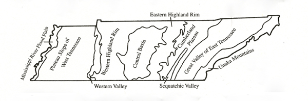
Figure 1. Physiographic provinces of Tennessee (Luther 1977).
Our knowledge of the prehistoric Indians of Tennessee is a result of over 150 years of archaeological investigations. Archaeology is the scientific discipline responsible for the recovery and interpretation of the remains of past cultures. Modern archaeology has three basic objectives: first, employing excavations and analysis based on scientific principles, archaeologists seek to develop temporal sequences of past cultures; second, archaeologists seek to reconstruct the lifeways of past human societies; and third, archaeologists address the evolution and operation of cultural systems—topics such as the origins of agriculture and changes in political organization. Places where cultural remains are found are called sites, and these may be as simple as a location where several arrowheads are found and as complex as a ten acre village and mound complex.
Scanty written information about the Indians of Tennessee and the Southeast come from chronicles of the sixteenth-century Spanish (Hudson 1990), seventeenth-century French (Williams 1928), and eighteenth-century British expeditions (King 2007). As Euro-American settlers moved westward across Tennessee in the late eighteenth and early nineteenth centuries, the many mounds and earthworks they encountered became a focus of speculative interpretation, often based on scripture or comparison to cultures in other parts of the world. The most pervasive was the theory of the Mound Builders which held that the ancient mounds were the remains of an extinct culture, likely the Canaanites and Lost Tribes of Israel (Silverberg 1968).
By the 1870s, antiquarian collecting and speculation were replaced with more systematic excavations in Middle (Jones 1876, Putnam 1878, Thruston 1890) and East (Thomas 1894) Tennessee and these clearly demonstrated that the prehistoric mounds and villages were constructed by the American Indians and that the occupants may have been ancestors of historic tribes of the Southeast. By the 1920s, excavations made it clear that many sites were occupied over time by successive Indian groups (Harrington 1922).
With the creation of the Tennessee Valley Authority in 1933, there began a massive archaeological recovery program using federal relief workers (CWA, WPA) in valleys to be inundated. Between 1934-1942, surveys and excavations were conducted in the Pickwick, Guntersville, Chickamauga, Kentucky, Watts Bar, Douglas, and Fort Loudoun reservoirs. In addition, limited excavations were conducted at the Obion, Link, Pack, and Mound Bottom sites in Middle and West Tennessee. This period saw the establishment of professional archaeology in the state and increased enormously our understanding of the prehistoric Indian occupations locally.
In the 1940s a technique to date organic material (charcoal, wood, bone, shell) from archaeological sites was developed. Called radiocarbon dating (Libby 1955), archaeologists were now able to determine how long ago sites had been occupied—and suddenly the Indian occupation of Tennessee became very long.
The 1960s and 1970s saw a series of state and federal laws enacted that are designed to protect, preserve, and manage archaeological sites (TCA 11-6-101 et seq., The Reservoir Salvage Act of 1960, National Historic Preservation Act of 1966, National Environmental Policy Act of 1969, The Archaeological and Historic Preservation Act of 1974, and the Archaeological Resources Protection Act of 1979). Among other things, these laws required that for any project on state or federal land, or that is funded by or permitted by state or federal agencies, the project must identify and mitigate the impact on archaeological sites. Consequently, there has been an enormous amount of archaeological work done in Tennessee over the past 40 years ranging from major reservoir projects such as the Tellico, Normandy, and Columbia, to road, bridge, sewer line, and transmission line projects.

Archaeologists divide the time humans have been in eastern Tennessee into periods. These periods are both references to some span of time, and to some stage in a continuum of increasing social complexity.
The result of the past 150 years of archaeological work is that we now know a lot about the prehistoric Indian occupation of Tennessee. Archaeologists divide the time people have been in Tennessee into a series of major periods (Figure 2). These periods are both references to a span of time and to a stage in a continuum of increasing social complexity. Ancient native peoples formed numerous and varied social and political groupings that changed through time during each of the archaeological periods. Although ancestral to native peoples of today, the ethnic and tribal affiliations of these ancient societies are unknown. The prehistoric peoples of Tennessee may well be the ancestors of several southeastern tribes.
The First Tennesseans: The Paleo Indian Period
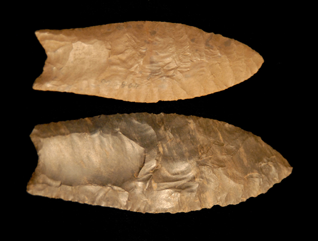
Figure 3. Clovis type spear points, lengths 5.4 and 4.7 inches. Ernest J. Sims Collection
One of the big issues in American archaeology is the peopling of the New World. The traditional explanation has been that during the last Ice Age, the sea levels were as much as 300 feet lower than today thus exposing a dry land bridge across the Bering Strait from Siberia to Alaska. Around 13,000 years ago, bands of hunters with their families crossed into North America and radiated across the continent, their presence recorded by Clovis points (Figure 3)—a distinctive lanceolate stone spear point with flutes or grooves on each face and named for the Clovis site in New Mexico where they were found in association with extinct mammoths.
In the last two decades evidence has mounted that suggest an earlier, pre-Clovis arrival of people into the New World (Malakoff 2008). Monte Verde, a site in Chile, is dated 14,500YBP (Dillehay 1989, 1997). Human feces from Paisley Caves, Oregon, have been dated 14,300YBP (Curry 2008); and genetic studies comparing modern Native American genes to native Siberians show that the populations diverged 15-20,000 years ago (Goebel et al. 2008). These and other data indicate a date of 15,000+ YBP for the beginning of the PaleoIndian period.
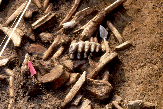
Figure 4. Mastodon molar and bones at the Coats-Hines site.
Evidence for PaleoIndians in Tennessee comes primarily from finds of fluted spear points and other distinctive cutting and scraping stone tools. Over 1,000 fluted points have been found across the state and over 100 sites identified. Concentrations of these artifacts may indicate the location of base camps where a number of activities would have occurred. A particularly good example is the Carson-Conn-Short site in Benton County (Broster and Norton 1993), which contains over forty hearths. The greatest concentration of evidence for PaleoIndian occupation is the western valley of the Tennessee River and the Central Basin particularly along the Cumberland River. This may be due to the high-quality chert resources in the western valley and the availability of mineral-rich soils, springs, and licks in the Central Basin where animals such as the mastodon, an extinct Ice Age elephant, likely congregated (Breitburg and Broster 1994).
Two sites show the direct association of humans with mastodons, At the Coats-Hines site in Williams County, thirty-four stone artifacts were found with the remains of a juvenile male mastodon (Figure 4); stone tool cut marks were present on a vertebra (Breitburg et al. 1996). At the Trull site in Perry County (Norton, Broster, and Breitburg 1998), a modified section of a mastodon tusk was found.
PaleoIndians have been often referred to as big game hunters, focusing on the now-extinct large animals of the last Ice Age (Figure 5). A more accurate description would be to call them generalized foragers who supplemented their diet of plant foods and small game with an occasional opportunistic killing of a mastodon. To understand the cultural organization of the PaleoIndians, archaeologists look at studies of living groups of foragers and construct theoretical models. Thus we believe that PaleoIndians were organized into bands in which several related families occupied and exploited a certain territory. A typical band may have numbered twenty to twenty-five persons and been comprised of a mother and father, their unmarried children, their married sons with their families, a few uncles and aunts, and a grandparent or two (this assumes that the society was organized along male lines; later societies were organized along female lines).
This social group had little political organization except for a nominal leader chosen perhaps for his hunting prowess. The band moved occasionally to take advantage of the seasonal availability of certain plants and animals, but probably also had a base camp where a greater portion of their time was spent. Bands would join with other bands from time to time to hunt game, to exchange items, or for marriage between groups. Religious beliefs probably focused heavily on a respect for and an explanation of various natural forces. Of particular importance would be ceremonies designed to assure success in the hunt and continued abundance of game. In times of sickness or stress, the band looked to a shaman who was thought to have received power from supernatural forces.
Clothing can be assumed to have been sufficient for the environment in which the group lived. Similarly housing would range from simple lean-tos to more elaborate enclosures as the weather and mobility warranted. One must realize that these bands did not wander aimlessly. Their culture was an adaptation to whatever situation they encountered, and although band level society seems “primitive” when compared to later more complex groups, it provided all the physical and spiritual needs of the group.
References
- Breitburg, Emmanuel and John B. Broster 1994 Paleoindian Site, Lithic, and Mastodon Remains in Tennessee. Current Research in the Pleistocene 11:9-11.
- Broster, John B. and Mark R. Norton 1993 The Carson-Conn-Short Site (40BN190): An Extensive Clovis Habitation in Benton County, Tennessee. Current Research in the Pleistocene 10:3-5.
- Curry, Andrew 2008 Ancient Excrement. Archaeology 61(4):42-45.
- Folmsbee, Stanley J, Robert Corlew and Enoch L. Mitchell 1969 Tennessee: A Short History. The University of Tennessee Press, Knoxville.
- Goebel, Ted, Michael C. Waters, and Dennis H. O’Rourke 2008 The Late Pleistocene Dispersal of Modern Humans in the Americas. Science 319(5869):1497-1502.
- Harrington, M.R. 1922 Cherokee and Earlier Remains on Upper Tennessee River. Museum of the American Indian, Heye Foundation, Indian Notes and Monographs, Miscellaneous Series No.24.
- Hudson, Charles 1990 The Juan Pardo Expeditions: Exploration of the Carolinas and Tennessee, 1566-1568. Smithsonian Institution Press, Washington.
- Jones, Joseph 1876 Explorations of the Aboriginal Remains of Tennessee. Smithsonian Contributions to Knowledge No. 259. Washington, DC
- King, Duane H. (editor) 2007 The Memoirs of Lt. Henry Timberlake: The Story of a Soldier, Adventurer and Emissary to the Cherokees, 1756-1765. Museum of the Cherokee Indian Press, Cherokee, NC.
- Libby, Willard 1955 Radiocarbon Dating. University of Chicago Press, Chicago.
- Luther, Edward T. 1977 Our Restless Earth: The Geologic Regions of Tennessee. The University of Tennessee Press, Knoxville.
- Malakoff, David 2008 Rethinking the Clovis. American Archaeology 12(4): 26-31.
- Morgan, William N. 1999 Precolumbian Architecture in Eastern North America. University Press of Florida, Gainesville.
- Norton, Mark R., John B. Broster, Emmanuel Breitburg 1998 The Trull Site (40PY276). Current Research in the Pleistocene 15:50-51.
- Putnam, Fredrick W. 1878 Archaeological Explorations in Tennessee. Eleventh Annual Report of the Trustees of the Peabody Museum of American Archaeology and Ethnology 2 (2):305-360).
- Silverberg, Robert 1968 Mound Builders of Ancient America: The Archaeology of a Myth. New York Graphics Society, Ltd.
- Simek, Jan F. and Alan Cressler 2008 On the Backs of Serpents: Prehistoric Cave Art in the Southeastern Woodlands. In David Dye, Cave Archaeology of the Eastern Woodlands: Essays in Honor of Patty Jo Watson, pp. 169-191. The University of Tennessee Press, Knoxville.
- Thomas, Cyrus 1894 Report on the Mound Explorations of the Bureau of Ethnology. Twelfth Annual Report of the Bureau of Ethology, Washington.
- Thruston, Gates P. 1897 Antiquities of Tennessee and the Adjacent States. Second Edition. The Robert Clarke Company, Cincinnati.
- Williams, Samuel Cole (editor) 1928 Early Travels in the Tennessee Country, 1540-1800. The Watauga Press, Johnson
City, Tennessee. - Yarnell, Richard A. 1993 The Importance of Native Crops during the Late Archaic and Woodland Periods. In Foraging and Farming in the Eastern Woodlands, edited by C. Margaret Scarry, pp. 13-26. University Press of Florida, Gainesville.