
Lehi Route from Jerusalem to Oman
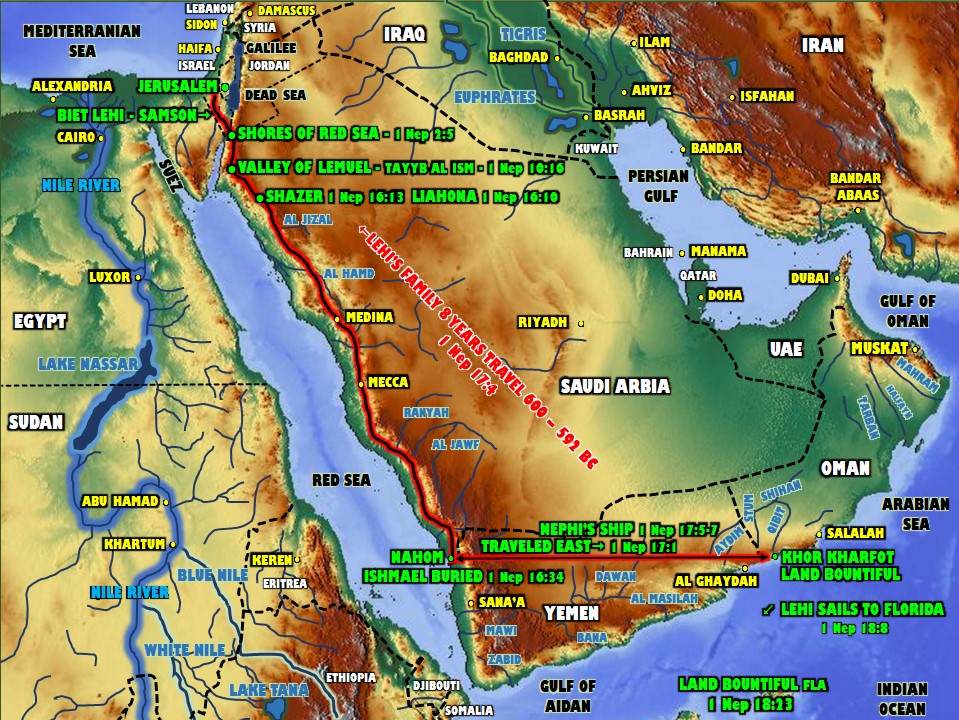
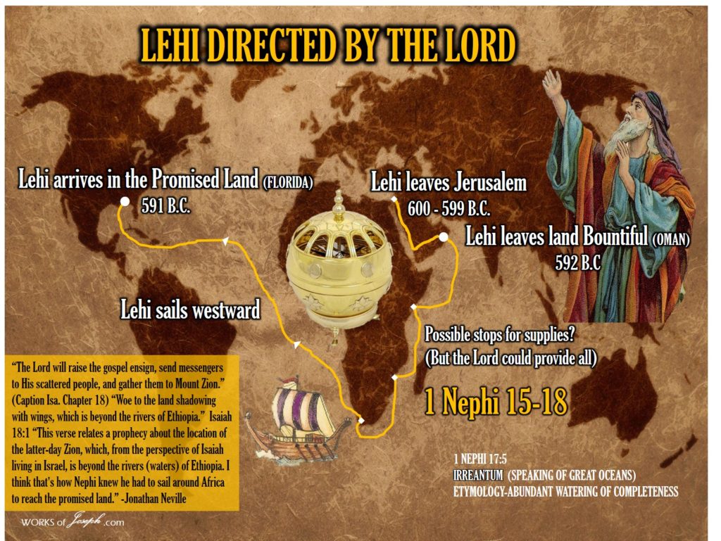
Follow the maps red line above to see Lehis journey from Jerusalem to Khor Kharfot, Oman. From there, Lehi traveled south west around Africa and from the Atlantic Ocean right into the Gulf of America and near Apalachicola, Florida.
Nephite Route Summary
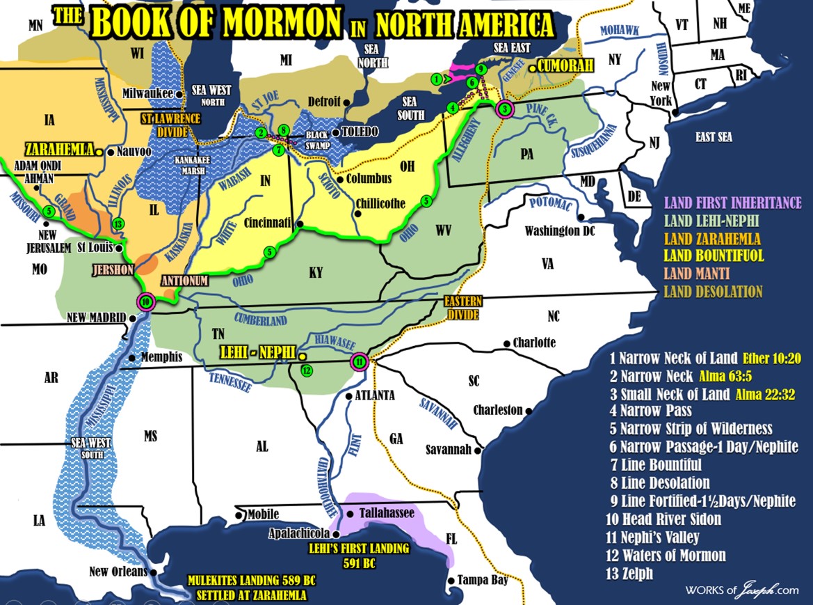
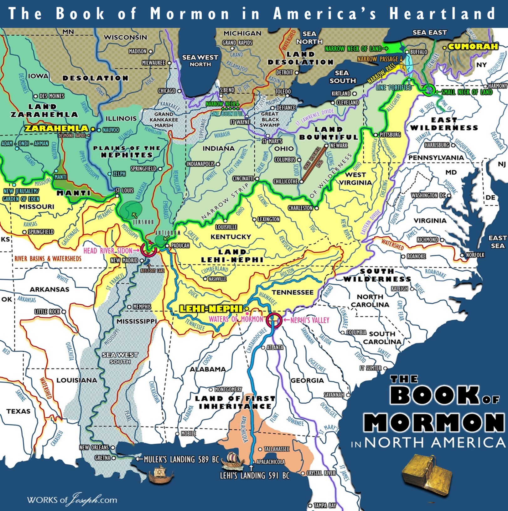
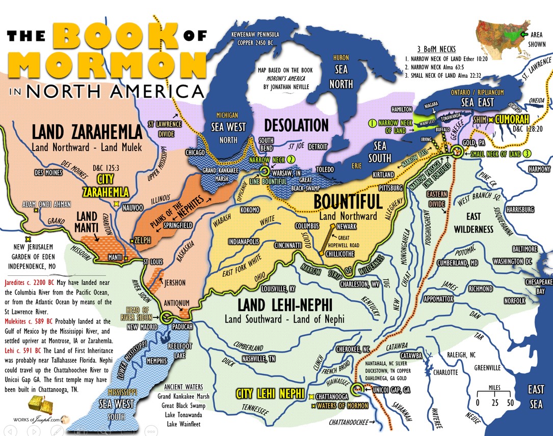
Follow me on a most fascinating and plausible migration pattern following the Trail of the Nephites, from the Land of First Inheritance near Tallahassee, FL to Nephi’s Valley near Unicoi Gap, GA, to the City of Nephi at Chattanooga, TN. We then continue with the Nephites travel on Mosiah’s River (Tennessee River) and up the Mississippi River (River Sidon) to the land of Zarahemla, (Illinois, Missouri, Iowa) with the City of Zarahemla being at Montrose Iowa across the river near Nauvoo, IL. The Nephites then continue North East through the Land Bountiful (Ohio, Pennsylvania) and then end up in New York at Hill Cumorah.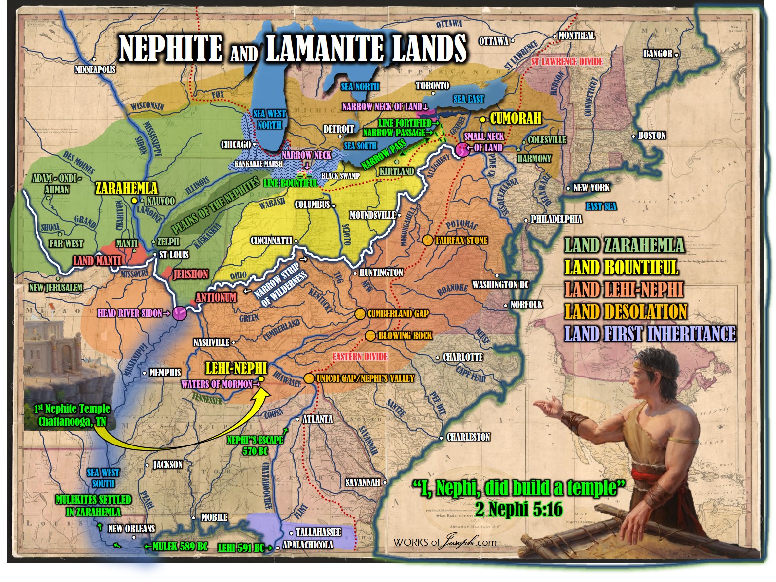 John Sorensen a Mesoamerican Theorist’s Quote vs Joseph Fielding Smith Quote (You Decide)
“There remain Latter-day Saints who insist that the final destruction of the Nephites took place in New York, but any such idea is manifestly absurd. Hundreds of thousands of Nephites traipsing across the Mississippi Valley to New York, pursued (why?) by hundreds of thousands of Lamanites, is a scenario worthy only of a witless sci-fi movie, not of history.” John L. Sorenson, Mormon’s Codex (Deseret Book, 2013), p. 688.
“…This modernistic theory of necessity, in order to be consistent, must place the waters of Ripliancum and the Hill Cumorah some place within the restricted territory of Central America, notwithstanding the teachings of the Church to the contrary for upwards of 100 years. Because of this theory some members of the Church have become confused and greatly disturbed in their faith in the Book of Mormon. It is for this reason that evidence is here presented to show that it is not only possible that these places could be located as the Church has held during the past century, but that in very deed such is the case… It is known that the Hill Cumorah where the Nephites were destroyed is the hill where the Jaredites were also destroyed. This hill was known to the Jaredites as Ramah. It was approximately near to the waters of Ripliancum, which the Book of Ether says, “by interpretation, is large, or to exceed all…
It must be conceded that this description fits perfectly the land of Cumorah in New York, as it has been known since the visitation of Moroni to the Prophet Joseph Smith, for the hill is in the proximity of the Great Lakes and also in the land of many rivers and fountains. Moreover, the Prophet Joseph Smith himself is on record, definitely declaring the present hill called Cumorah to be the exact hill spoken of in the Book of Mormon. Further, the fact that all of his associates from the beginning down have spoken of it as the identical hill where Mormon and Moroni hid the records, must carry some weight. It is difficult for a reasonable person to believe that such men as Oliver Cowdery. Brigham Young, Parley P. Pratt, Orson Pratt, David Whitmer, and many others, could speak frequently of the Spot where the Prophet Joseph Smith obtained the plates as the Hill Cumorah, and not be corrected by the Prophet, if that were not the fact. That they did speak of this hill in the days of the Prophet in this definite manner is an established record of history.” Doctrines of Salvation Joseph Fielding Smith Chapter 12
Personal Revelation
“I urge you to stretch beyond your current spiritual ability to receive personal revelation, for the Lord has promised that “if thou shalt [seek], thou shalt receive revelation upon revelation, knowledge upon knowledge, that thou mayest know the mysteries and peaceable things—that which bringeth joy, that which bringeth life eternal.” Revelation for the Church, Revelation for Our Lives by President Russell M. Nelson
Heartland Updated Idea of the Waters of Mormon Location
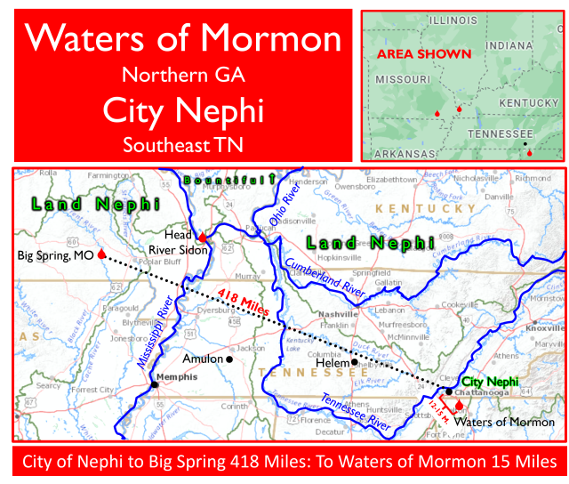
Heartland Model and Rod Meldrum in the past used to think Big Spring, MO was the potential Waters of Mormon, as Rod mentions in his book, “Exploring the Book of Mormon in Americas Heartland”. Since about 2015 Rod along with Jonathan Neville, Wayne May and myself have thought very different about its location. Big Spring, MO is a beautiful spring and many from Rod’s tours have definitely felt a special spirit nearby.
But, Rod with myself and others over the past years have now determined since we are in agreement that the most plausible location of the City of Nephi, is near Chattanooga, TN. This means Big Spring, MO would be over 415 miles away from the City of Nephi. That is too far for Alma to baptize in the borders of the City Nephi. Rod likes both possibilities of Crawfish Springs or Catoosa Springs, GA. This article will explain why Firm Foundation believes this way. Of course we just share information and you can decide. (see Mosiah 18:4-5)
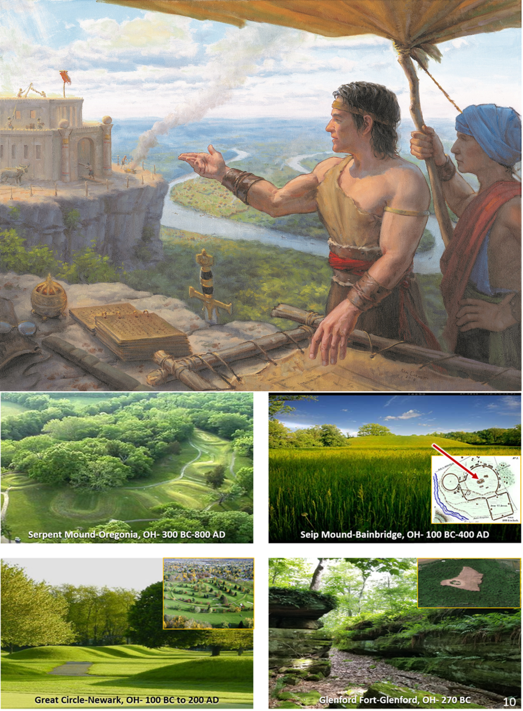
Hopewell/Nephite Parallels
At the 24th Book of Mormon Evidence Conference, I shared a presentation with our guests about how the Nephite Culture of the Book of Mormon has so many amazing similarities to the Hopewell Culture in the United States, both dated from c.600 BC to 400 AD . Sign up for Videos here. Many archaeologists, scientists and historians who aren’t members of the Church of Jesus Christ of Latter-day Saints, know and believe the history of the Hopewell Culture and verify the dating which parallels the Book of Mormon. At the links below, you will also find the fantastic article I referenced of a discussion between Archaeologist of Ohio William Mills in 1917 with James E. Talmadge.
My talk along with all of those from this previous conferences are streaming on our new online streaming service today. Currently we have over 900 fantastic videos you can choose from. Our Subscription site is HERE and my presentation title is, “Nephite Hopewell Parallels” found here:
Read a blog about the Parallels of the Hopewell Culture and the Nephite Culture here, and read more details in the Annotated Book of Mormon by David Hocking and Rod Meldrum on pages 536-537.
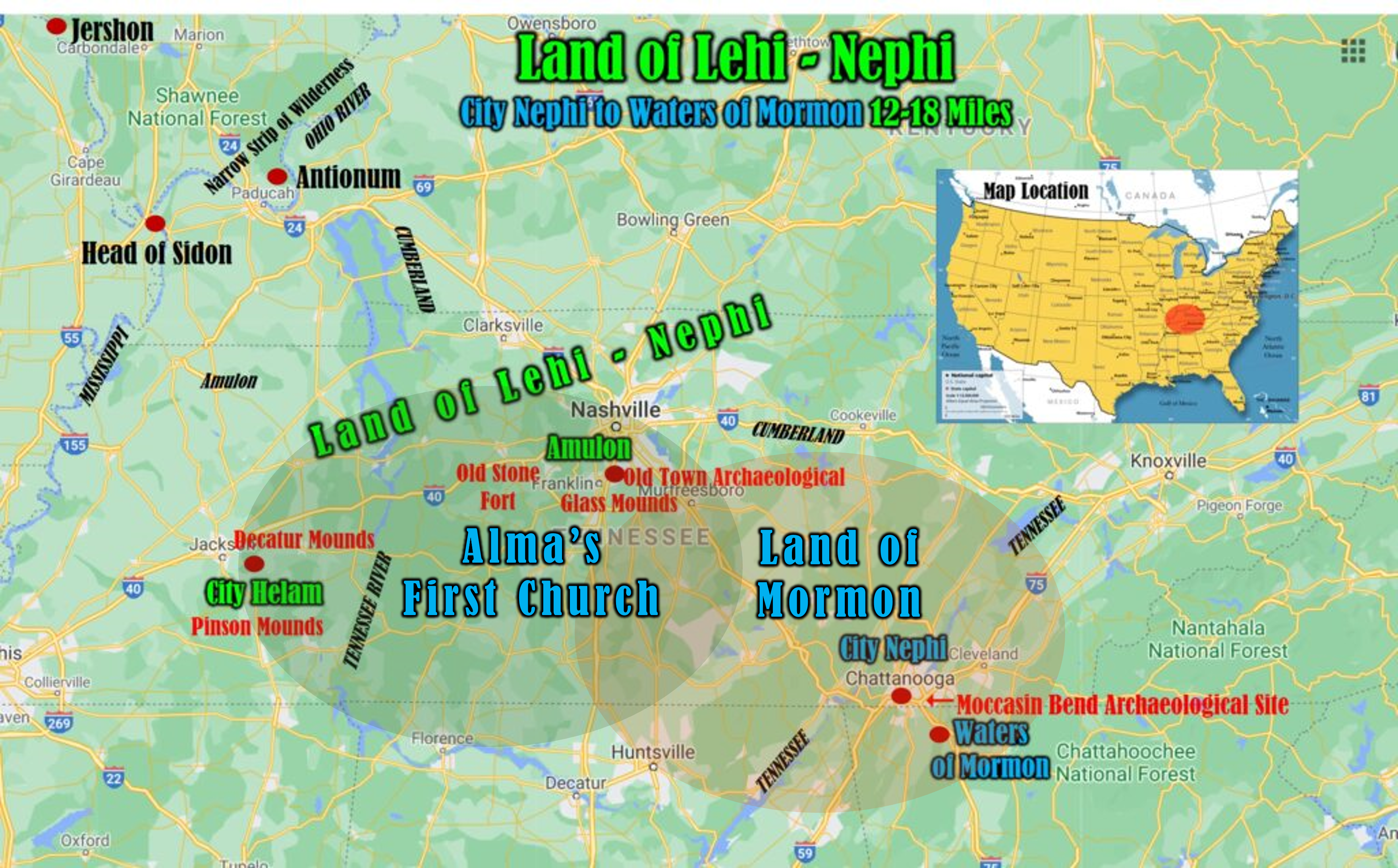
TRAIL OF THE NEPHITES-
Lehi and Family Land near Apalachicola, FL
Book of Mormon Evidence.org believes The Book of Mormon events in the New World occurred in North America. The Church of Jesus Christ of Latter-day Saints is neutral on this subject. Our information is based on archaeology, anthropology, text of the Book of Mormon, distances, geology, and we believe the many rivers were the highways of the ancients including the Nephites. We believe Lehi landed in Florida near Tallahassee at a place called Apalachicola, FL on the gulf coast about 589 BC. See blog on Landing near Apalachicola here:
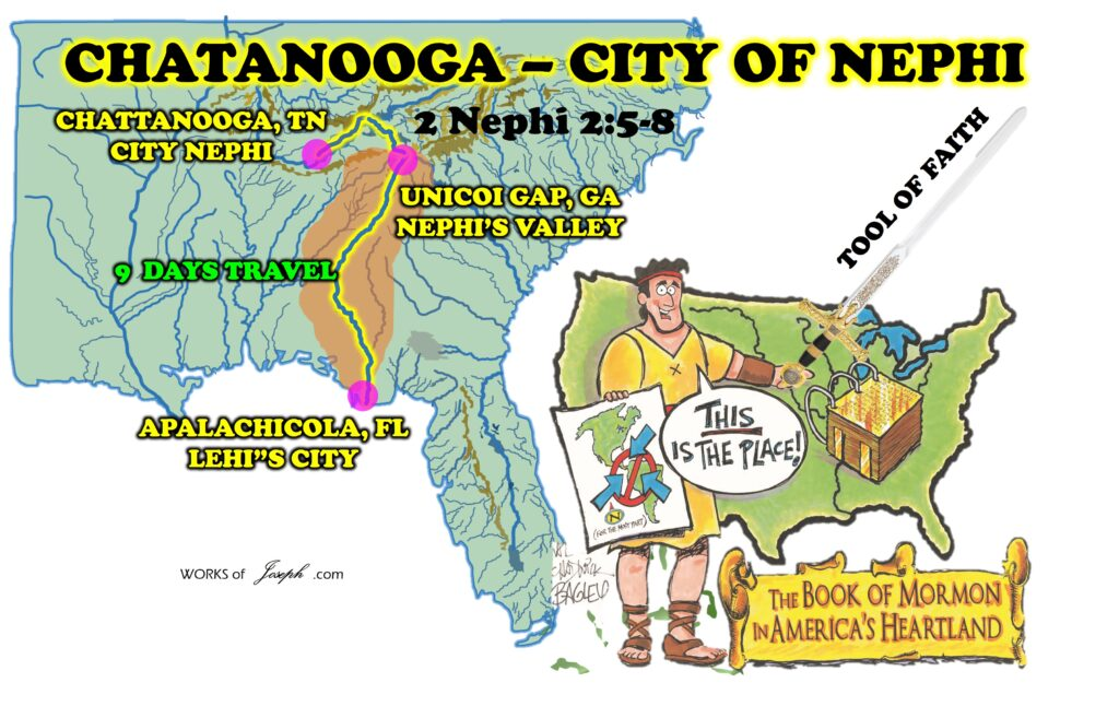
Nephi Escapes to Unicoi Gap Georgia
After Lehi dies about 570 BC. Nephi escaped from his brothers north probably using the Apalachicola River which turns into the Chattahoochee River, with them pitching their tents near Unicoi Gap, GA.
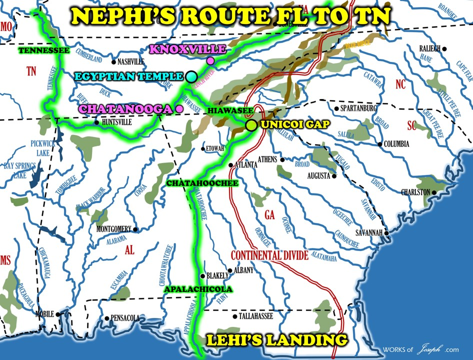
The head of this Chattahoochee River is only 1,700 feet from the head of the Hiawasee River. Traveling on the Hiawasee River about 100 miles it connects to the Tennessee River. The Nephites could settle near Chattanooga, Tennessee as that would make sense on a large river, and mountains of gold, silver, and copper nearby. Also the ancient Seneca Trail is right there. This area of Northern Georgia and Southeastern Tennessee became the land of Nephi and also called the Land Lehi-Nephi. Near Knoxville, TN on the Clinch River was found what archaeologists call an ancient Egyptian Temple discovered in 1935 and dated very ancient.
TRAIL OF THE NEPHITES-
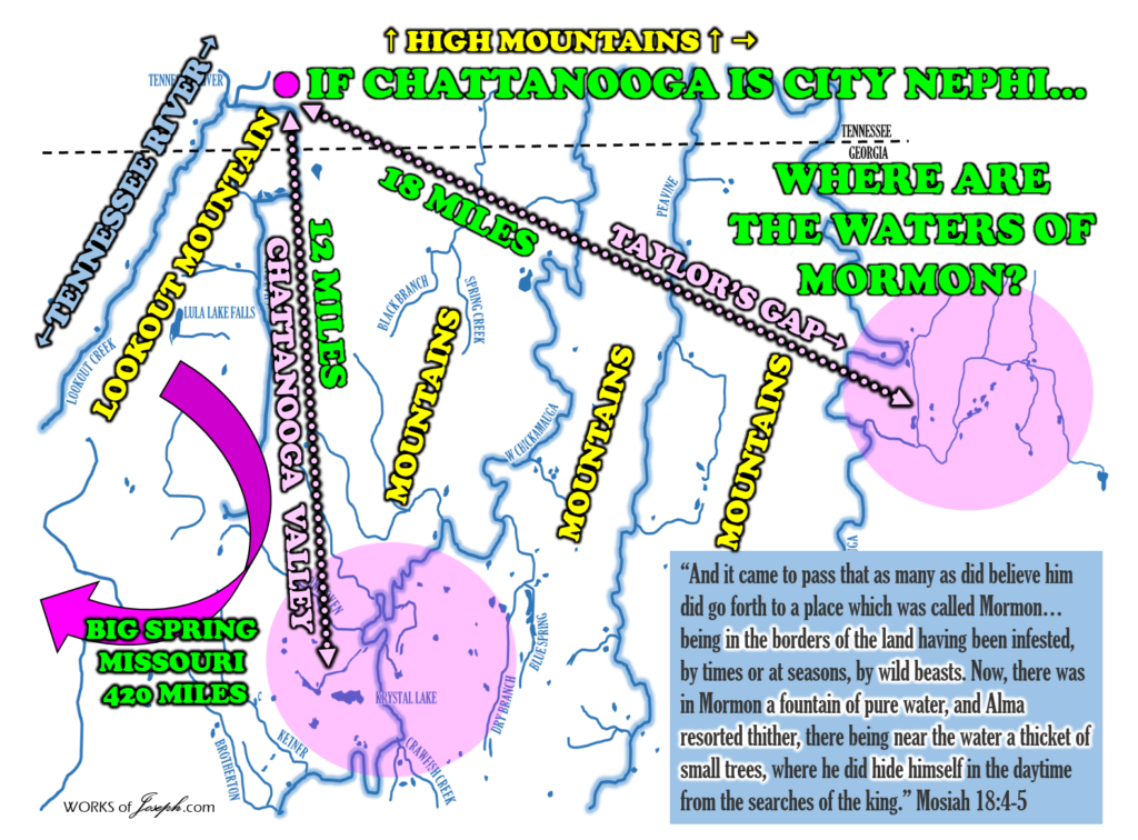
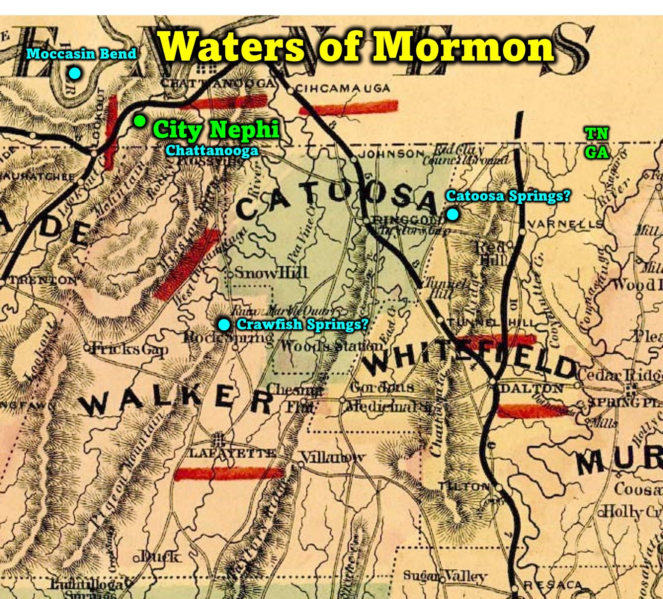
If Chattanooga, TN is near the City of Nephi, then where would the Waters of Mormon be?
Waters of Mormon Possibilities
Catoosa Springs, GA
“Due to its unique geological formation, there has always been an Indian village in the gap of White Oak Mountain and Taylor’s Ridge in Ringgold, Catoosa County, Georgia. This was a woodland village, primarily early to middle woodland, occupied roughly from 600 B.C. to about 700 A.D. There is a little bit of late archaic artifacts that go back to roughly 2000 B.C.,” Randall Frank The Catoosa County Historical Society
50 MINERAL SPRINGS
INHABITED 1500 BC +
ARTIFACTS 600 BC
10 MILLION GALLONS OF PURE WATER PER DAY
Crawfish Springs, GA
“Human occupation of the area that came to be the City of Chickamauga dates from the Woodland period (1000 BCE to 1000 CE) .” City of Chickamauga Historic Resources Survey, June 15, 2013
“In the “Fork-field,” as it was known, are a number of mounds built by earlier people of whom the Cherokees knew nothing.” Historic Chickamauga Georgia Sacred ground: History lives on at Crawfish Springs in Chickamauga By Jenni Frankenberg Veal
20 MILLION GALLONS PER DAY
PURE WATER FOR CRAWFISH
INHABITED 1,000 BC – 1,000 AD
STRATEGIC CIVIL WAR LOCATION
MCLEMORE COVE HISTORIC DISTRICT 1000 BC TO 1300 AD
Wild Beasts
“And it came to pass that as many as did believe him did go forth to a place which was called Mormon, having received its name from the king, being in the borders of the land having been infested, by times or at seasons, by wild beasts.
The map below shows you the area of Bison Migration in the Heartland of the United States. Note there is a group that migrated along northern Georgia where we propose the Waters of Mormon exist.

(Complete Blog about Bison here)
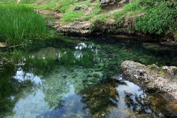
Now, there was in Mormon a fountain of pure water, (Catoosa and Crawfish above) Alma resorted thither, there being near the water a thicket of small trees, where he did hide himself in the daytime from the searches of the king…
And it came to pass after many days there were a goodly number gathered together at the place of Mormon, to hear the words of Alma…
And now it came to pass that Alma took Helam, he being one of the first, and went and stood forth in the water, and cried, saying: O Lord, pour out thy Spirit upon thy servant, that he may do this work with holiness of heart.
And when he had said these words, the Spirit of the Lord was upon him, and he said: Helam, I baptize thee, having authority from the Almighty God, as a testimony that ye have entered into a covenant to serve him until you are dead as to the mortal body; and may the Spirit of the Lord be poured out upon you; and may he grant unto you eternal life, through the redemption of Christ, whom he has prepared from the foundation of the world. And after Alma had said these words, both Alma and Helam were buried in the water; and they arose and came forth out of the water rejoicing, being filled with the Spirit.
And again, Alma took another, and went forth a second time into the water, and baptized him according to the first, only he did not bury himself again in the water.
And after this manner he did baptize every one that went forth to the place of Mormon; and they were in number about two hundred and four souls; yea, and they were baptized in the waters of Mormon, and were filled with the grace of God.” Mosiah 18:4,5-7, 12-18
More Nearby Possibilities for the Waters of Mormon
Red Clay State Park, Blue Hole, TN
Moccasin Bend, TN
Chickamauga, GA
Later, after Lehi dies, Nephi escaped his brothers north possibly using the direct route on the Chattahoochee River to Unicoi Gap, GA which I call Nephi’s Valley as he traveled “many days” (7-9 days by river) and then “set up tents.” Nephi next could travel the Hiwassee River which flowed north and was only 1,700 feet from the mouth of the Chattahoochee River. From the Hiawassee River which connects to the Tennessee River is about 100 miles then, settling near Chattanooga, Tennessee which was the City of Nephi and the land around the City of Nephi called the Land Lehi-Nephi. As Nephi was on the Hiawassee Rive he would have seen the many precious ores all around the eastern mountains of Chattanooga, TN. Much later, Mosiah was told by the Lord to leave Tennessee (about 323 BC) and he traveled the Tennessee River west then north to the Ohio River then traveling north on the Mississippi River, to the land of Zarahemla (modern Illinois, Iowa, Missouri). Eventually Mosiah made his way to the city of Zarahemla at Montrose Iowa (D&C 125:3), where the Mulekites already lived. 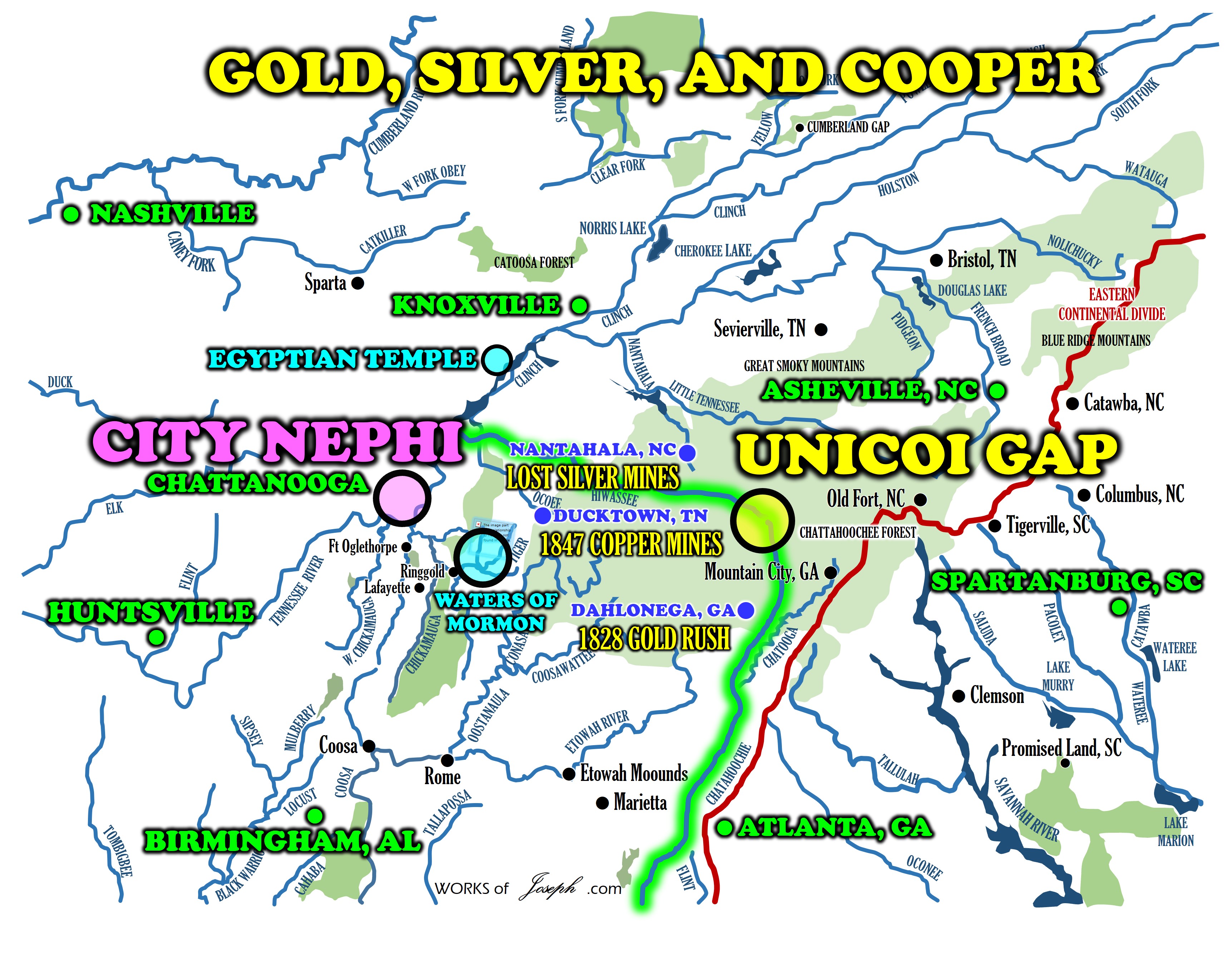
Mulekites 586 BC and Mosiah 323 BC
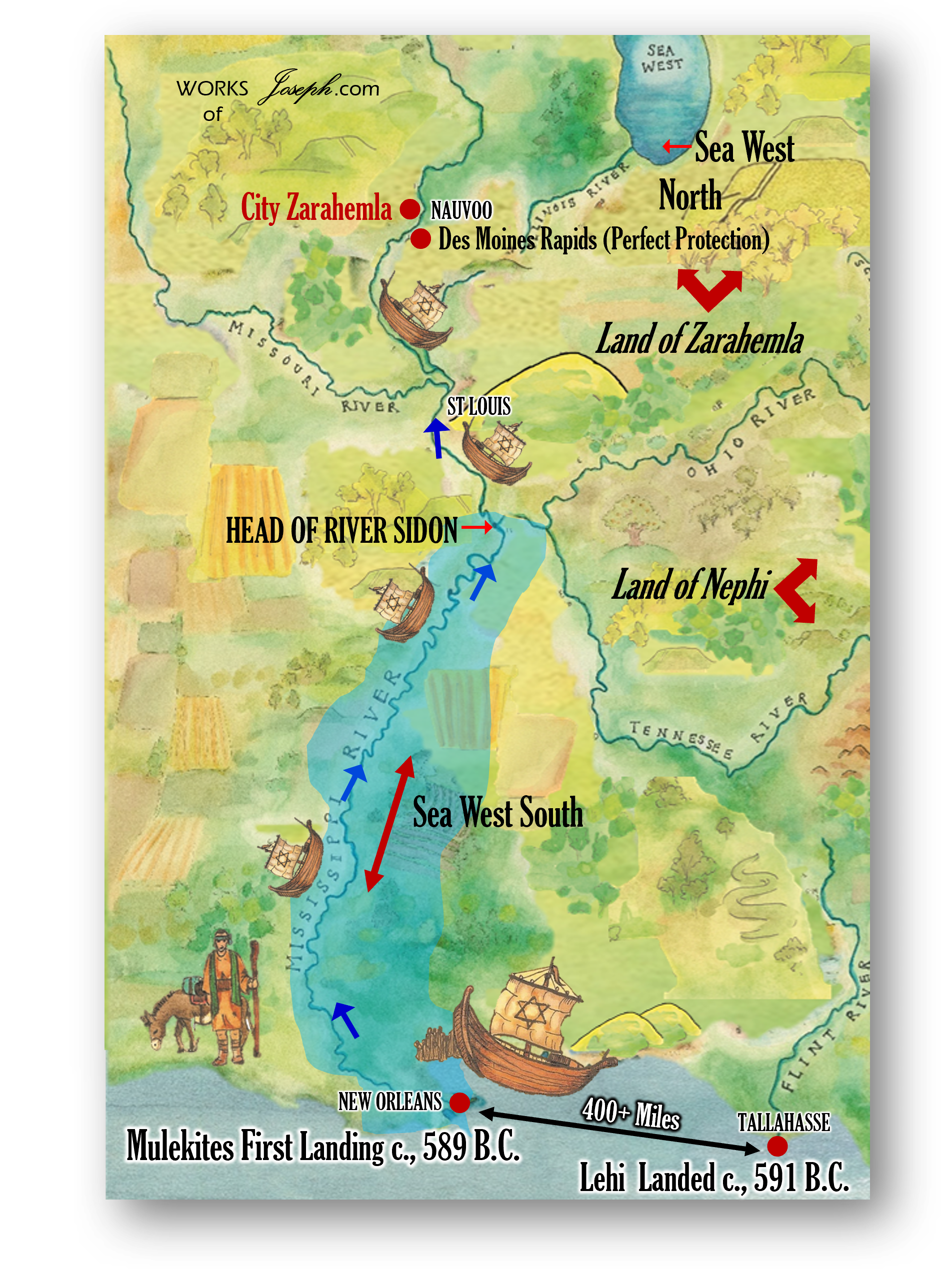 Shortly after Lehi left Jerusalem for the new World, in about 586 BC the Mulekites (Descendants of King Zedekiah) came from Jerusalem by way of the Atlantic Ocean and ascended the lower and upper Mississippi Rivers until they stopped at the Des Moines river rapids near Nauvoo. They lived along the Mississippi river (the land of Zarahemla) until Mosiah arrived from the land of Nephi. Mosiah meets the people of Zarahemla and translated Coriantumr’s stone. (Read Omni 1:17, 21). “The Mulekites could have easily sailed up the river without encountering the Nephites or the Lamanites, who were several hundred miles east. Furthermore, the Mulekites would have sailed right past other civilizations that likely existed in the area, descendants of Jaredites or other groups who have come to the continent. This geography helps clarify why the Nephites never encountered Zarahemla until Mosiah was prompted to flee from the land of Nephi.” Moroni’s America page 101
Mosiah 11, 19-22 by Moroni’s America
“Mosiah 11:12 relates that King Noah, Zeniff’s son, built “a very high tower, (See Lookout Mountain in Chattanooga, TN in two pictures below) even so high that he could stand upon the top thereof and overlook the land of Shilom, and also the land of Shemlon, which was possessed by the Lamanites, and he could look over all the land round about.”

If King Noah wanted to look over all the land round about, there could hardly be a better place to do so than Lookout Mountain which rises out of the river valley above Chattanooga to a height of almost 2,400 feet. On clear days, mountains 100 miles away are visible from the summit. The tower was near the temple, but there is no description of where the temple was. It may have been enclosed in walls within the city, or it may have been built on a high place, which would explain why Noah built his tower near the temple. In Mosiah 19, Gideon chased King Noah to the tower, from which Noah saw “the army of the Lamanites were within the borders of the land” (verse 6). It is unlikely a tower could be high enough to provide such a panoramic view unless it was built on a high place, such as Lookout Mountain. If the Book of Mormon did not take place in or around Chattanooga, it had to have taken place somewhere with similar topographical features.
Mosiah 22 describes the escape of king Limhi and his people. They give wine to the Lamanite guards, and when the guards are drunk, they escape at night out the “back pass, through the back wall, on the back side of the city.” The text gives no hint of direction, but it does explain that “they went round about the land of Shilom in the wilderness, and bent their course towards the land of Zarahemla, being led by Ammon and his brethren.” This means Limhi’s people went to Zarahemla following the route Ammon took. (see map)
- Nephites are feeding Limhi’s flocks near the river.
- Their only chance to escape the Lamanites would be south towards Lehi-Nephi on the Tennessee River.
- Remember Ammon’s possible routes would give him an advantage when escaping as he knew the best direction to leave. Caney’s, Duck, or Elk River. Moroni’s America page 126-27
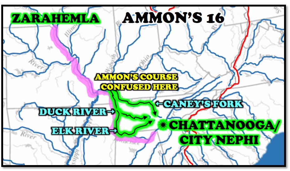
The Lamanites would not have expected this, so apparently there were no guards along that route. A Lamanite army pursued Limhi’s people for two days, but then lost their tracks, probably at a river. This suggests that Limhi’s people traveled overland for a while before reaching a river, which is consistent with the proposed route Ammon took when he followed a river to its source and then crossed land to reach the hills overlooking the land of Shilom [Which is just north of Chattanooga]. With the Lamanite army in pursuit, it seems unlikely that the people of Limhi could have built boats quickly enough to accommodate all the people, their animals, and their provisions. Perhaps they walked down the river far enough to hide their tracks and then continued overland. The text implies the journey took a long time: “after being many days in the wilderness they arrived in the land of Zarahemla” (Mosiah 22:13). [Near Nauvoo, Illinois]
Mosiah 18, 23-24 Moroni’s America
These chapters focus on Alma. When Alma “fled from the servants of king Noah” (Mosiah 18:1), [See map below] he didn’t go far. He “went about privately among the people” to teach the gospel. Those who believed him went to the “place which was called Mormon, having received its name from the king, being in the borders of the land having been infested, by times or at seasons by wild beasts” (Mosiah 18:4).![]()
![]()
![]()
![]()
 The place of Mormon seems unusual, being close enough to the city of Lehi-Nephi for Alma to go about privately teaching, yet also in the borders infested by wild beasts. It was notable enough that the King named it, another indication of its proximity. One possible location for the “infested” land is the mountain ranges east of Chattanooga, [See map above of where the ore is located] which are natural borders and would harbor migrating or hibernating animals such as bears or wolves.
Verse 5 offers more description of the place Mormon: [Waters of Mormon]
5 Now, there was in Mormon a fountain of pure water, and Alma resorted thither, there being near the water a thicket of small trees, where he did hide himself in the daytime from the searches of the king. There are plentiful natural springs in this area of Tennessee, [And Northern Georgia] some of which are tourist attractions today. The “thicket of small trees” suggests this particular fountain had been cleared, possibly to be developed as a water source.![]()

We believe two great candidates for the Waters of Mormon are Catoosa Springs and Crawfish Springs, Georgia, both within 15 miles of the City Nephi or Chattanooga, TN.
Moroni’s America continues, “Eventually, the king sent spies and found out where Alma was assembling with his followers. (I think the spies took names and told the king, who sent his army to round up Alma’s followers.) The Lord warned Alma that the king’s army was coming, so he alerted the people (about 450 of them) and they “departed into the wilderness” (Mosiah 18:34) with their tents and families, as well as their flocks and grain (Mosiah 23:1). Although the text does not give us directional information, it seems likely that Alma would move in the direction of Zarahemla—north and west—instead of deeper into Lamanite territory. They “fled eight days’ journey into the wilderness and they came to a land, yeah even a very beautiful and pleasant land, a land of pure water” (Mosiah 23 3-4). They called the land Helam and “they built a city, which they called the city of Helam” (Mosiah 23: 19-20). There are many places in Tennessee that fit this description. One candidate that has been preserved and can be visited today is Pinson Mounds, located approximately 200 miles northeast of Chattanooga and 28 miles from the Tennessee River. The 400-acre site is elevated above wetlands and a river that form its southern border. Over 30 mounds were constructed here over a long period of time. The probable age of some features is between about 100 B.C. and A.D. 260,[i] a reasonable fit for Alma’s early development in about 145 B.C. As is typical of many sites, mounds were added and developed in later years. The site includes the “second-tallest mound in the United States (Saul’s Mound, at 72 feet) and a circular earthen enclosure similar to earthworks found in the Ohio Valley.”[ii] Could Alma and his people travel 200 miles in 8 days? That’s an average of 25 miles per day, or about 8-10 hours of walking (or canoeing) at 2.5 to 3 miles per hour. Because they were fleeing from the Lamanites, this seems a reasonable estimate, even for a large group with animals. Alma’s people settled in for two decades. About 20 to 24 years later, though, the army of Lamanites that was chasing Limhi’s people (and had found the priests of king Noah in the land of Amulon) came across Alma’s land of Helam. Alma surrendered to the army. An initially strange thing about this account is that this army chased the people of Limhi for two days before losing their tracks, at which point “they were lost in the wilderness” (Mosiah 22:16). How could they become lost after two days when they were following the tracks of a group of people? Even if they got lost, couldn’t they have simply turned around and made their way back to Lehi-Nephi? One possible answer is they feared being killed by the king of the Lamanites if they returned empty-handed. We learn in Mosiah 23 that they “had followed after the people of king Limhi” and “had been lost in the wilderness for many days” (Mosiah 23:30). This suggests they did not stop the pursuit of Limhi when they lost the tracks. Maybe they continued down the river. Every fork in a river must be explored, a laborious process. At some point, the Lamanites stumbled upon the priests of king Noah, led by Amulon. Amulon and his brethren joined the Lamanites, but for some reason, Amulon also didn’t know the way back to the land of Nephi.
Continuing with the proposed geography, if the Lamanites had chased king Limhi’s people to the Duck River, they would have eventually reached the Tennessee River at a point about 30 miles downriver from a point due east of Pinson Mounds. They could have found Amulon in that area, a successful discovery that would have made it possible to return to their king. Hence, they “were traveling in the wilderness in search of the land of Nephi when they discovered the land of Helam” (Mosiah 23:35). This sequence suggests they didn’t recognize the Tennessee River—the way back to the land of Nephi. Maybe they followed tributaries into the land of Helam. Alma had no problem showing them “the way that led to the land of Nephi” (Mosiah 23:37), which suggests the “way” was obvious, even though the Lamanites had missed it. What obvious “way” could there be other than a river? Alma would simply have to lead the Lamanite army to the Tennessee River and explain they needed to go upriver.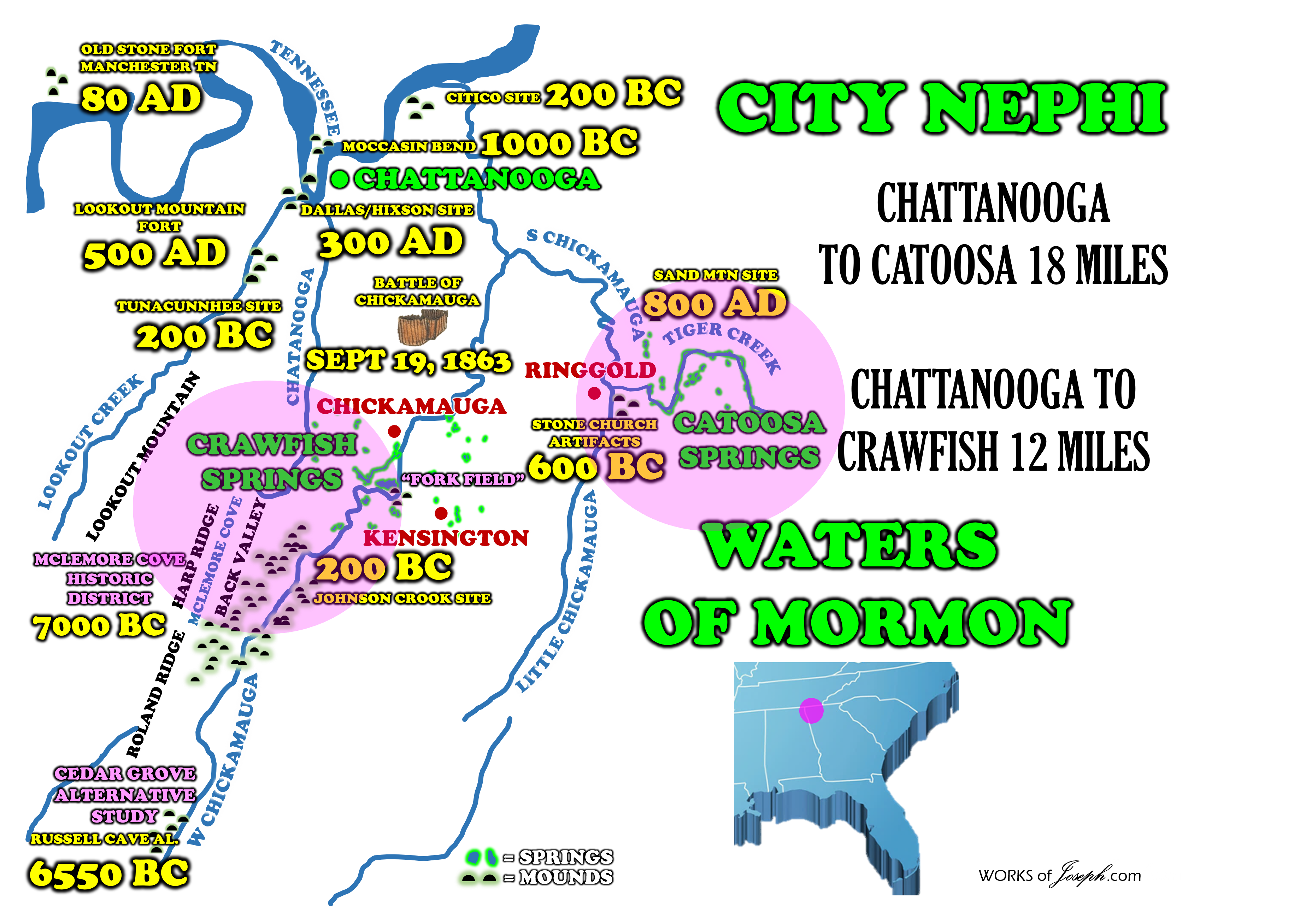 Of course, this is merely one of many scenarios possible in this area of the country. There are many other rivers and archaeological sites in Tennessee where the events described in the text could have taken place. Pinson Mounds is plausible, based on the text, and I like it because it can be visited today. Most ruins from this time period have been destroyed. Other plausible alternative settings for the land of Helam would likely be about the same distance northwest from the city of Nephi.” Moroni’s America by Jonathan Neville page126-130 [i] Robert C. Mainfort, Jr., Pinson Mounds: Middle Woodland Ceremonialsim in the Midsouth (University of Arkansas Press, Fayetteville, 2013), p. 197. [ii] Robert C. Mainfort, Jr., and Mary L, Kwas, “Pinson Mounds State Archaeological Park,” The Tennessee Encyclopedia of History and Culture, online here
Why Chattanooga as the City of Nephi?
Let’s now speak more about the location of the Waters of Mormon below. We believe two great candidates are Catoosa Springs and Crawfish Springs both within 15 miles of the City Nephi or Chattanooga, TN. We will look at some of the history of both locations. Rod Meldrum and I used to think Big Spring MO was the Waters of Mormon, but we have now determined since we are confidant that the City Nephi is in Chattanooga, TN and that means Big Spring would be over 430 miles away for Alma to baptize nearby. 1.City/land of Nephi is higher in elevation than land of Zarahemla and place of first landing. 2.Land of Zarahemla is north of Nephi, but downstream; Tennessee River is one of the few that flows north. 3.King Noah built a tower that let him see at least 3 lands, so it had to be high. (Lookout Mountain 2,400 FT) 4.Archaeology shows the area was inhabited during the relevant time periods.
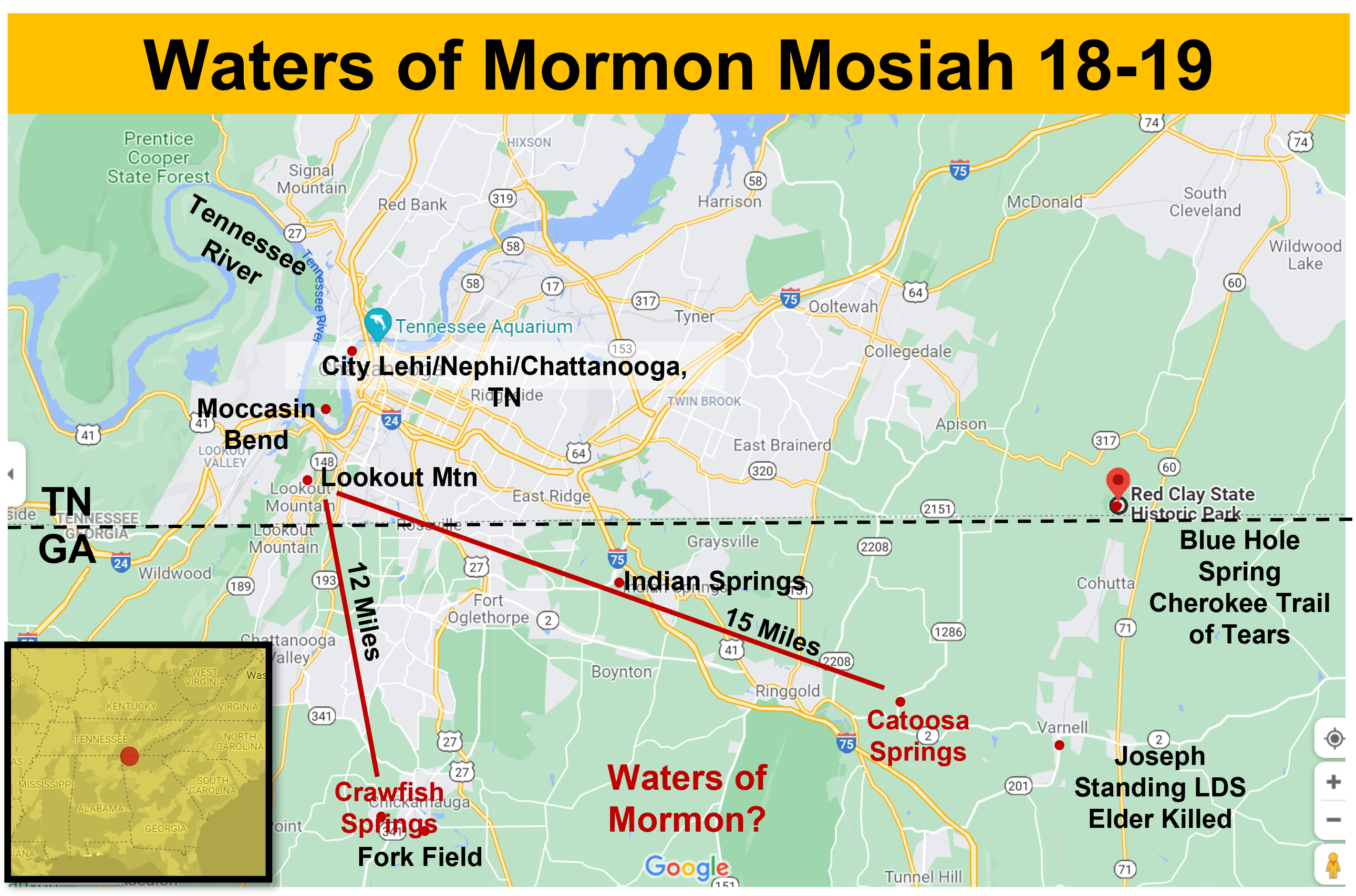
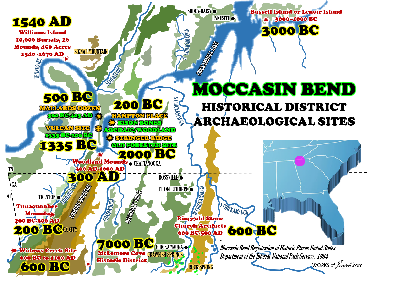
Moccasin Bend National Archeological District

Moccasin Bend National Archeological DistrictMoccasin Bend is one of the most unique units found in the entire National Park Service system, spanning 12,000 years of continuous human habitation.
 There are three areas for visitors to access Moccasin Bend National Archeological District. The “Gateway Site,” is a grassy meadow located along Hamm Road. The site is an open green space that overlooks the Tennessee River, and can be reached by taking the Manufacturers Road exit off of Highway 27 and turning left. Then turn left onto Hamm Road, and the Gateway Site will be on your left. Additionally there are two developed trails on Moccasin Bend – The Brown’s Ferry Federal Road and the Blue Blazes Trail.
|
Moccasin Bend reserve has produced many archaeological finds.
American Indians used this land as a place for a home as long as 12,000 years ago. During the Paleo-Indian Period (10500–8000 BC), Moccasin Bend served as a home for Paleo-Indians. These people evidently had a highly mobile hunting and gathering way of life. The artifact markers for this period include a variety of fluted, semi- fluted, and un-fluted lanceolate projectile points. The Paleo-Indian period corresponds to the end of the Pleistocene Era.[10] During the Woodland Period (700 BC-1000 AD,) there were major changes evolving with the needs of the Indian people. The use of bow and arrows became the primary way of hunting and pottery became widely popular throughout the Indian tribes. From the Woodland Period, artifacts have been found on Moccasin Bend. During the Mississippian Period (AD 1000–1630), the American Indians resided on Moccasin Bend in large villages enclosed by corn fields and other agricultural necessities. The Mississippian Period was also the time of interaction with the Spanish to the area, starting with Hernando de Soto‘s march through the area in 1540. Moccasin Bend was very important area of land at this time. “The bend’s history of human habitation, spanning 12,000 to 14,000 years, is unique. Research suggests that Moccasin Bend may be the nation’s most significant repository of Native American history… Americans of the Paleolithic and Archaic periods, and later the Woodlands and Mississippian periods, naturally gravitated there over millennia, establishing a succession of villages and major towns. Sparse and respectful exploration of 18 important sites on the bend have yielded abundant evidence of habitation across these eras. Tools, Clovis points, pottery shards, remains of houses, and innumerable burial sites document a concentration of Native American habitation virtually unmatched in the Southeast. Among the bend’s most celebrated archaeological sites are the Vulcan site, where midden deposits, hearths, and pit house features have been radiocarbon-dated to 1335 b.c., and Hampton Place, near the heel of the bend, where remains show that a large, palisaded Indian town existed for a time dating from at least 1430 a.d.” Retracing the Trail of Tears—Land & People, by Harry Austin editorial page editor of the Chattanooga Times . “At times of relatively high water flow, the bottomland was dissected to create an island on what is now the westernmost part of Moccasin Bend. This part-time island and other areas on the floodplain afforded the Archaic Indians attractive campsites so that during this period of first occupation the bend would have seen a series of camps constructed by bands of nomadic hunters and gatherers. In the later Archaic period, around 2000-1000 B.C., more permanent camps were present as shown by the remains of a dwelling at the Vulcan Site. Still later in time, during the archaeological Woodland Period, (1000 B.C. – A.D. 1000), the bend was occupied by Indians who had invented pottery making and primitive horticulture and had developed a complex social and political system in which extensive exotic material trade networks played a major role. During Woodland times, villages were established on the bend at the Vulcan, (40HA140), Mallards Dozen, (40HA147), and Hampton Place, (40HA146), sites. __ In the later part _of this period, a person would have seen various groups of Woodland Indians burying their dead by constructing mounds of earth over the deceased. At least seven of these mounds were constructed at sites 40HA133, 40HA141, 40HA142, 40HA143, 40HA144 and 40HA145. Later after periodic flood waters had deposited additional layers of sand and silt covering up the remains of previous camps and villages, the bend was occupied by agriculturally oriented Indians. During this period Mississippian (A.D. 1000 to first European contact), you would have seen clusters of houses built of vertical posts interwoven with cane and plastered with mud, roofed with native grasses surrounded by a palisade of vertical logs. Fields of corn, squash and beans would lie outside the palisade and there would also be a few individual houses scattered around the area. Sometime in the middle to late sixteenth century, many or all of the houses in the village areas now known as the Hampton Place site burned, preserving some of their contents and affording a glimpse of the way Indians lived at this critical time of first contact with European explorers.
The river flood waters again covered the village remains and when the first settlers came, Moccasin Bend was attractive farm land. Its next period of historical significance came during the Civil War when U.S. Army troops constructed artillery positions on Stringers Ridge to protect supply routes leading into Chattanooga and to bombard Confederate positions it forms Moccasin Bend, a large open agriculturally productive area which has been intermittently occupied for the past 10,000 years. Geography has played a key role in the historical development of Moccasin Bend. At the time of earliest known human use, the archaeological Archaic Period (10,000 B.C. to 1000 B.C.), the river would sweep south along Stringers Ridge carrying sand and silt, then curve west around the foot of Lookout Mountain and continue northward. The impact with Lookout Mountain and influx of water and silt from Lookout Creek caused the river to slow down and release part of its sand and silt load on the west side of Stringer’s Ridge to protect supply routes leading into Chattanooga and to bombard Confederate positions.” Moccasin Bend Registration of Historic Places United States Department of the Interior National Park Service
Big Spring, MO Edit
Note: Rod Meldrum used to think Big Spring, MO was the Waters of Mormon as he mentions in his book, “Exploring the Book of Mormon in Americas Heartland”. It is a beautiful spring and you definitely can feel a special spirit nearby. But, Rod has over the past few years now, determined since he is confidant that the City Nephi is near Chattanooga, TN then that means Big Spring, MO would be over 430 miles away from the City of Nephi. That is too far for Alma to baptize in the borders. Rod likes both possibilities of Crawfish Springs or Catoosa Springs, GA. What do you think? Remember none of us know the exact location of most of these Book of Mormon locations. However, a few things we believe strongly are very evident that the only hill Cumorah is in Ontario, NY, Zarahemla is across the river from Nauvoo, IL, and the Plains of the Nephites are in Ohio, Indiana, and Illinois. We believe Joseph Smith knew these locations and shared them in Section 125 of the Doctrine and Covenants here and Section 128 here, and in his Letter to Emma that we have a copy of at the Joseph Smith Papers here. Also, read Rod’s article “The Scriptural Basis for Book of Mormon Geography” here.
Catoosa Springs
 50 MINERAL SPRINGS USED FOR A HOSPITAL OF HEALING DURING THE CIVIL WAR INHABITED 1500 BC + “Due to its unique geological formation, there has always been an Indian village in the gap of White Oak Mountain and Taylor’s Ridge in Ringgold, Catoosa County, Georgia. This was a woodland village, primarily early to middle woodland, occupied roughly from 600 B.C. to about 700 A.D. There is a little bit of late archaic artifacts that go back to roughly 2000 B.C.,” Randall Frank The Catoosa County Historical Society
Catoosa ARTIFACTS 600 BC
“The artifacts are in very good shape,” she said. “They are older than we realized they were.” Catoosa County Historian and former State Rep. William H.H. Clark, who is currently writing “The History of Catoosa County Volume 2,” recently went to West Georgia College in Carrollton with archaeologist Lawrence Alexander of Wildwood, Ga., and Society member Alva Crow to examine 13 boxes of artifacts recovered by the state archaeologist around 1960. Clark was a driving force behind retrieving the exhibit pieces. “In 1959, they were constructing I-75 through the gap of the mountain,” Clark said. “They got started and realized they were on top of a (Native American) village located between the south end of Anderson Cemetery and the Ford (dealership). They could not stop the development of the highway so the Georgia Department of Transportation and state archaeologist came in and for two summers did a salvage excavation. They hired quite a number of high school students to help them search.”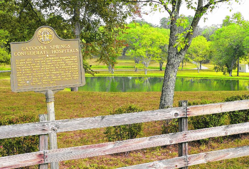 According to Lawrence and Clark, they worked to get the most photogenic specimens. “While there, we discovered the Chieftain Museum in Rome had gone through and picked out the best (artifacts) and were displaying them in Rome, but they were going to give up the collection,” Clark said. Alexander, who has a Masters degree in anthropology from the University of Alabama, was on hand to assist with the design of the exhibit when it was placed March 12. “This was a woodland village, primarily early to middle woodland, occupied roughly from 600 B.C. to about 700 A.D.,” he said. “There is a little bit of late archaic artifacts that go back to roughly 2000 B.C., but 99 percent of (the artifacts are) woodland.” These woodland dates would roughly date the artifacts to around the time of the Hebrew Kings David and Solomon from Biblical times.” Randall Frank The Catoosa County Historical Society
There was a significant mound near Ringgold Gap that was between the southern ends of Anderson Cemetery and where I-75 is now. It was described by Union officers in 1864 and seemed to be 50 to 60 feet across and 20 feet high. The mound was destroyed when I-75 was built in the early 1960s. Several Ringgold High School history classes assisted archeologists from West Georgia College in collecting artifacts from the mound that were reported to be extensive. One reports seeing a white marble alter at the site, suggesting there was a place of worship, or spiritual center at this mound site between the conjunction of the Little Chickamauga and the South Chickamauga Creeks. Artifacts retrieved from the site have been on a traveling exhibit and are now on display at the Stone Church Museum[ [From 600 BC]…Other important sites in the county are Catoosa Springs, which were used as medicine springs by the Cherokees due to the minerals and healing properties of the water. The Catoosa County community of Graysville was once known as “Opelika,” and was a Cherokee village. The Cherokee ceremonial grounds were at the intersection of Temperance Hall Road and the Alabama road in Woodstation. Here the Cherokees held dances and would sing and dance for several days and nights at a time.“ Catoosa County Native American History” By Nancy Harris Crowe
Due to its unique geological formation, there has always been an Indian village in the gap of White Oak Mountain and Taylor’s Ridge in Ringgold, Catoosa County, Georgia. The gap in the mountains provided sanctuary for many years to several Southeastern tribes that preceded the Cherokee. The Napoche, Uchee, and Coosa Indians were among the first inhabitants of the region and were called the Mound Builders. Their mounds can be seen at the Etowah Mound site near present day Cartersville, GA. The descendants of the Mound Builders were the Muskogean, or Creek Indians. They built villages along the creek banks, and inhabited this region until encroaching white settlements pushed the Cherokees down from Virginia and Tennessee.
Crawfish Springs
20 MILLION GALLONS ON FRESH WATER PER DAY PURE WATER FOR CRAWFISH INHABITED 1,000 BC – 1,000 AD “Human occupation of the area that came to be the City of Chickamauga dates from the Woodland period (1000 BCE to 1000 CE) .” City of Chickamauga Historic Resources Survey, June 15, 2013 “In the “Fork-field,” as it was known, are a number of mounds built by earlier people of whom the Cherokees knew nothing.” Historic Chickamauga Georgia Sacred ground: History lives on at Crawfish Springs in Chickamauga By Jenni Frankenberg
STRATEGIC CIVIL WAR LOCATION MCLEMORE COVE HISTORIC DISTRICT 1000 BC TO 1300 AD
Springs of Northern Georgia- Crawfish Springs- Waters of Mormon?
As you read below some of the spectacular history of Crawford and Catoosa Springs you will understand why we have selected these as possible locations for the Waters of Mormon. From the History of Walker County we read, “No section is favored with a greater variety of springs than this county. [Walker] The Medicinal Springs, owned by the Gordons, are situated at the base of Taylor’s Ridge. There are twenty springs within the space of a half mile; but the main springs are twelve in number, on a beautiful eminence of Taylor’s Ridge. The trees have been cut down. From this spot may be seen various mountains. Cherokee Springs are at the base of Taylor’s twenty-four miles from Chattanooga. Yate’s Spring is five miles from Gordon’s Spring. Crawfish Spring is twelve miles from Gordon’s Catoosa Springs are one and a half miles from the State Road. We give the following extracts concerning these springs from an account written by Mr. S. Rose, one of the editors of the Georgia messenger: Imagine to yourself an elevated cove, or basin, in the Blue Ridge, surrounded almost entirely by towering eminences. From the eastern slope a bold, clear brook comes tumbling into the valley, and passes rapidly westward, until it escapes between two abrupt mountain peaks, and dashes for half a mile over rocky barriers into a branch of the Chickamauga. On the borders of this brook, and in the center of this basin, which I shall designate “The Vale of Springs” there is a level spot about two acres in extent, within the limits of which I have counted no less that fifty-two distinct, bold, and well-defined springs. The waters are strongly mineral. “All these springs seem to issue either from the mountain side, upon a bed of hard, black slate, or boil up through the slate. They are perennial: the most severe and continued droughts make no perceptible difference in the quantity of water which they discharge. The country around is protected by its native forests. The atmosphere is pure, dry and bracing, and entirely free from disease, or from any cause which could product it. “Immediately in the rear of the springs there are two beautiful mountain peaks, from the summits of which visitors might enjoy an extensive prospect of the surrounding country. “There is a pond in Chattooga Valley called the Round Pond. It embraces four or five acres, forty-eight feet deep in the middle, of a sea green color. Tradition says two Indians were drowned in this pond. There is no visible outlet and the water never becomes stagnant. Long Pond is a beautiful sheet of water, famous for excellent fish. “Among the first settlers of this county were: X.G. McFarland, T. G. McFarland, Josh Spradlin, Mr. Allman, J.R. Brooks, General Newman, Mr. Acock, S. Marsh, S. Fariss, Jesse Land, J.T. Story, Robert Boyle, B. McCutchins, A. Hughes, S. Dunn, Lawson Black, Wm. Hardin, James Park, John Caldwell, John Wicker, Joseph P. McCullough. “Walker has many caves, among which the most remarkable is Wilson’s Cave. We extract from “Sears’ Wonders of the World” the description given by some persons of a visit which they make in 18— “The company being met, with lighted torches we entered the cave, through a small aperture, descending a flight of natural stairs, almost perpendicularly, some ten or twelve feet. Coming to the most magnificent room we ever beheld, and being desirous of viewing as minutely as we could, from the amplitude of this anomaly of nature, and illuminated the place as far as we were able b the means we had, when we discovered that an almost infinite number of stalactites had been formed bh the continual dripping of the water, resembling, in size and appearance, various animal bodies. “Being somewhat satisfied with our examination of the apartment, with our hearts glowing with wonder, love, and praise to the Architect of Nature, we moved slowly and rather pensively along this solitary and hitherto unexplored mansion, through devious wiles of incognita loca, in quest of new discoveries. “Having reached the extreme end of this spacious dome, we found that to proceed further, we had to ascend stupendous and almost inaccessible eminences, over craggy precipices and awning gulfs, to the height of some fifth or sixty feet, when, by the dim light of our tapers, we discovered through a small opening into another room, less extensive but far more beautiful and picturesque; for there appeared to the astonished beholder not only a representation of a part of the animal creation, but a true delineation of a great number on inanimate objects, such as cones, altars, pyramids, tables, candle-stands, with a facsimile of some of nature’s choicest productions; and it really appeared as if she, in her wild and playful moments, had intended to mock the curiosities of art.” “General Daniel Newman died in the county. He merits the remembrance and respect of the people of Georgia. In the Indian Wars he proved himself a good soldier. Besides holding many high offices in the State, he was a member of Congress from 1831 to 1833.” (History of Walker County, Georgia Chapter 30 page 204-206 White’s Historical Collections, published in 1854, devotes several pages to Walker County. For showing the changes since that time, and for its general interest, it is copied and reproduced herewith)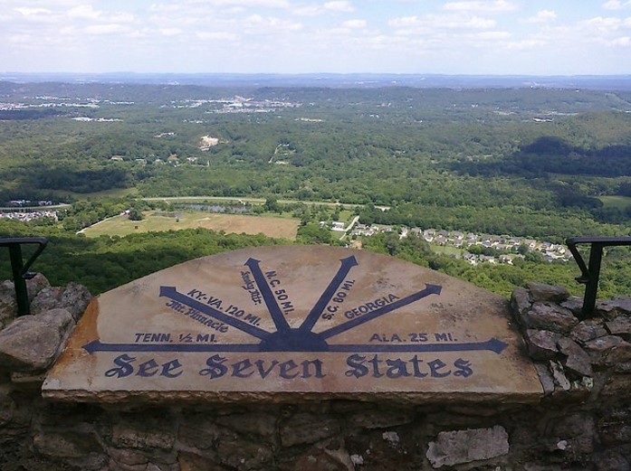 “Human occupation of the area that came to be the City of Chickamauga dates from the Woodland period (1000 BCE to 1000 CE). This was a time of hunting, gathering, small-scale agriculture, modest villages, and burial mounds. The Mississippian period (900-1600 CE) succeeded the Woodland. These people cultivated maize on a large scale; lived in palisaded towns; and built prominent, platform-type mounds. The Etowah Mounds, north of Cartersville, GA, date from this period. The limestone springs have always been an attraction for human activity. Named for a Cherokee chief, Crawfish Springs emerges at the head of a ravine, just east of Cove Road. Approximately 20 million gallons of water are produced per day, and it currently serves as the back-up water supply for Walker County and the City of Chickamauga water systems.” City of Chickamauga Historic Resources Survey, June 15, 2013 Atlanta Preservation & Planning Services, LLC “The Cherokees cleared some of the lands in the fork made by the spring stream and the Chickamauga Creek, about four or five acres, which was as much as they usually cultivated. In the “Fork-field,” as it was known, are a number of mounds built by earlier people of whom the Cherokees knew nothing. This was James Gordon’s first home.” Historic Chickamauga Georgia Sacred ground: History lives on at Crawfish Springs in Chickamauga, Ga. By Jenni Frankenberg Veal
History of Chickamauga published in 1979 by Espy Publishing Co., “Cherokee arrowheads were produced en masse downstream from Crawfish Springs on a piece of land formerly known as Fork Field. A large number of arrowheads were found there in the years before the field was cultivated.” 1.The Lithic stage 8000 BC 2.The Archaic stage 8000 TO 2000 BC 3.The Formative stage 1000 BC TO 500 AD ADENA, EARLY WOODLAND 4. Middle Woodland period (200 BC–500 AD) 5.The Classic stage 500 TO 1000 AD LATE WOODLAND MISSISSIPPIAN 6.The Post-Classic stage 1200 TO 1500 AD LATE MISSISSIPPIAM 7. HOPEWELL 200 BC TO 500 AD [Nephites] 8.ADENA 1000 BC to 200 BC [Jaredites]
Sixty Million Gallons of Pure Water Flow Daily from a never Failing Spring. Can be pumped to Any Part of the Town. CRAWFISH SPRING http://chickamaugacampaign.org/pdfs/crawfishspring.htm
150 Page Map BOOK or 210 Page Book + 20×30 Fold Out Map
I personally love Crawfish Springs as my Waters of Mormon and Jonathan Neville loves Catoosa Springs as his location. Please do some research and see what you feel. That is how we learn. What are the pros and cons of each one and is there a better choice you can find? If you can find a better choice, or tell me where think the Waters of Mormon is located, and share it with me. To help you decide you can either copy pages on this blog or I can email you a few of my Waters of Mormon maps as you see in the blog, for FREE!
History of Walker County
South of Kensington GA 12 miles south of Chickamauga. United States Department of the Interior National Park Service National Register of Historic Places Continuation Sheet Section 7 NPS Form 10-900-a 0MB Approved No. 1024-0018
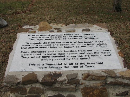
Blue Hole Spring/Cherokee Trail of Tears Begins
Red Clay State Historic Park encompasses 263-acres of narrow valleys formerly used as cotton and pasture land. The park site was the last seat of Cherokee national government before the 1838 enforcement of the Indian Removal Act of 1830 by the U.S. military, which resulted in most of the Cherokee people in the area being forced to emigrate west. Eleven general councils were held between 1832 and 1837. Red Clay is where the Trail of Tears really began, for it was at the Red Clay Council Grounds that the Cherokee learned that they had lost their mountains, streams and valleys forever. The park is home to a natural landmark, Blue Hole Spring, which arises from beneath a limestone ledge to form a deep pool that flows into Mill Creek, a tributary of the Conasauga and Coosa River system. The spring was used by the Cherokee for their water supply during council meetings. Red Clay State Historic Park has a 100-person capacity picnic pavilion and 18 individual picnic tables. The picnic shelter may be reserved up to one year in advance and is equipped with a grill, a water fountain and restrooms. Individual picnic tables each have a grill and are available on a first-come, first-served basis. The park also features an amphitheater that can seat up to 500 people. The amphitheater can be reserved and often used for musical and theatrical performances. The James F. Corn Interpretive Facility contains exhibits on the 19th century Cherokee, the Trail of Tears, Cherokee art, a video theater, gift shop and small library. https://tnstateparks.com/parks/info/red-clay At the time the first troops arrived at the park there were nine deep drilled wells, besides several wells at farmhouses and a number of cold springs which had been considered pure. These springs and wells were cleaned out and the wells provided with pumps by the park commissioners before the water was used. These wells and those subsequently sunk were piped to the bottom with six-inch iron tubing, which projected two or three feet above the surface of the ground. The pipes above the ground were protected by stone laid in cement for the purpose of preventing surface drainage getting into the wells. The principal springs outside the park are Crawfish Springs, capacity, say, 15,000,000 gallons per day, distance 1½ miles; Blue Springs, distance, 3 miles; Ellis Springs, distance, 4 miles. All furnished good and abundant water. The water supplied the camp was obtained from the springs above mentioned, hauled in barrels furnished by the Quartermaster’s Department to the different regimental organizations from the nine wells in existence in the park before the arrival of the troops, and thirty-six more that were rapidly sunk in convenient localities, and from Chickamauga Creek. The wells furnished one barrel per minute by vigorous pumping. The use of Crawfish Springs was discontinued about July 1 on account of disagreement with the owner as to compensation, and the direct supply from that source was cut off. The park commissioners put in a water system at Chickamauga Creek, where it touches the park on its northern and eastern corner. An intake was constructed at that point, a power house erected and furnished with steam pumping machinery, with a capacity of 1,800,000 gallons per day, and a reservoir with a capacity of 17,000 gallons was erected some distance from the pump house upon an elevation sufficiently high so that the water could be distributed through the various portions of the park by gravity. The water-pipe line was about 10 miles in length and extended to the camps of numerous regiments. Chickamauga Creek has its source some 20 miles distant from the park, in the highlands, and is fed by numerous springs, the most important of which are Pond, Gowdy, Owen, Lee, and Crawfish.
Filters were used to a limited extent, but their use amounted to but little, as they soon clogged with the large amount of solid substances which were held in suspension in the water. At first all the wells in the camp furnished cool and pure water, but later some of them became contaminated and their use was discontinued. Whether any of those which were not discontinued were contaminated may be a mooted question, but the evidence before us does not warrant the statement that such was the fact. A very considerable quantity of the water used for drinking during July and August was drawn from the springs above mentioned, which were located outside of the park, the procuring of which was at times a serious inconvenience. There were but few bathing houses, soldiers generally bathing below the intake in Chickamauga Creek. The troops washed their clothing in water obtained from the pipe system, from the wells and springs, and in Chickamauga Creek. The water supply at Camp Thomas was at times insufficient for comfort, especially when the largest number of troops were there. At these times of shortness of water considerable inconvenience and discomfort were caused, but it did not amount to distress. It is very difficult to determine from the evidence to what extent impure water contributed to the production of sickness, but it is probable that it did to a considerable degree. The men would drink any clear water without much thought as to its source, and it appears that they used water which was known to be impure and which was forbidden. In some cases this practice was induced no doubt by disinclination to drink the roily water from Chickamauga Creek.
Eternal Flames in Tennessee
The Cherokee maintained a fire at their seat of government, and carried coals to the Oklahoma Territory. Coals from that fire were used to relight the eternal flame at Red Clay State Park near Blue Hole springs, the last seat of the independent Cherokee Nation. The Cherokee People Eternal Flame, located on the Qualla Boundary in Cherokee, North Carolina, is another example of a flame first lit on the Oklahoma Cherokee Reservation and carried as hot coals back to the homeland. Memphis, at the grave of Elvis Presley at his home Graceland ia another one.
MCLEMORE COVE HISTORIC DISTRICT
The McLemore Cove Historic District is significant as a geographically well-defined rural area reflecting the patterns of agricultural and rural development in Northwest Georgia for more than a century.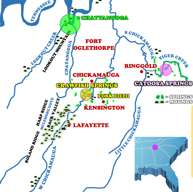 The mountain also contains an area known as “The Pocket.” Located in the northwest section of the mountain, this area contains several rare plant species. This “pocket” is a small patch of mesic hardwood forest in which grow at least eleven significant species found nowhere else in Georgia. Examples of some of these uncommon plants include bent trillium, nodding spurge, lance-leaf trillium, wild hyacinth, celandine poppy, Ohio buckeye, log fern, Virginia bluebells, hairy mock-orange, and blue ash. The Pocket is considered one of the most remarkable botanical areas in northwest Georgia.
ARCHAEOLOGICAL RESOURCES – PREHISTORIC
 A 1986 reconnaissance level survey of an area in Back Valley between Lookout Mountain and Harp and Roland Ridges found a diversity of site types and time periods. The report concluded: “that this area was extensively utilized throughout the Archaic and Woodland periods. Archaic use was probably based in habitation camps and they probably maintained those locations for relatively long periods of time. Woodland use probably involved revisiting certain locations for specialized activities. Both occupations would have had brief hunting camps… Since raw material is so plentiful… expedient tool manufacture and use may be common… All aspects of tool manufacturing were evident on sites surveyed. There are extensive chert deposits which were used by the aboriginal population!” (Cedar Grove Alternative) The Cedar Grove Alternative study recorded sixty-eight prehistoric sites in the Back Valley area. About two-thirds of the sites require additional work to determine National Register eligibility and three sites were described as “the kinds of sites…which could offer much more information with little additional work.”
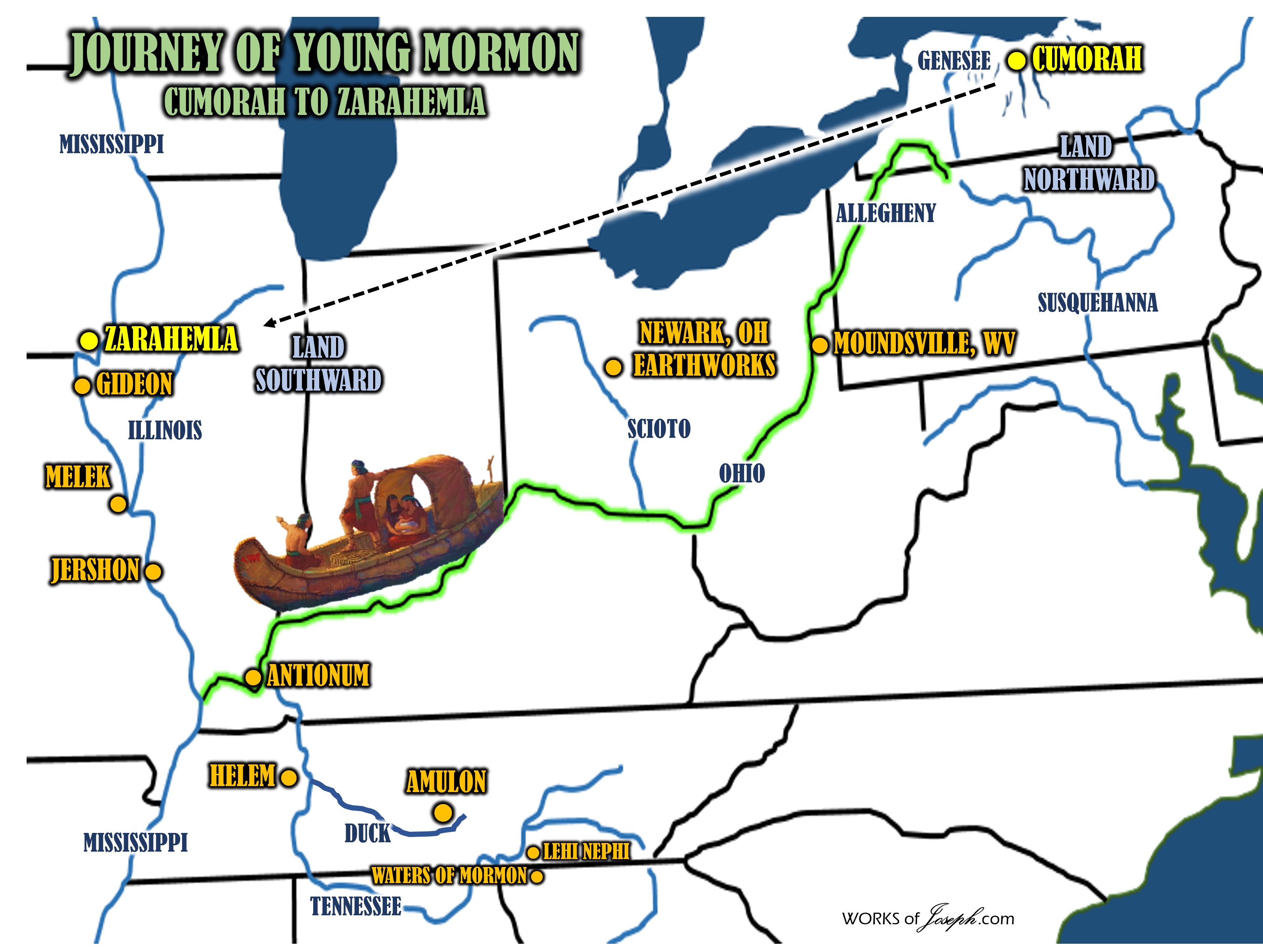
Main Over all Maps
[…] The map above depicts a possible route that Mormon and his son Mormon may have traveled in a Nephite type canoe. They began in the Cumorah area as we know from scripture they were near the hill Shim. (See Mormon 1:3). We also know the Land of Mormon was named after Mormon (See Mosiah 18:4), and would most generally be located as indicated on the map near the Waters of Mormon, which we have said is very plausible to be near the City Nephi near Chattanooga, Tennessee. (Blog Here) […]
Comments are closed.