 Mike LaFontaine sent me this article below that is from the Sept 1973 Ensign.
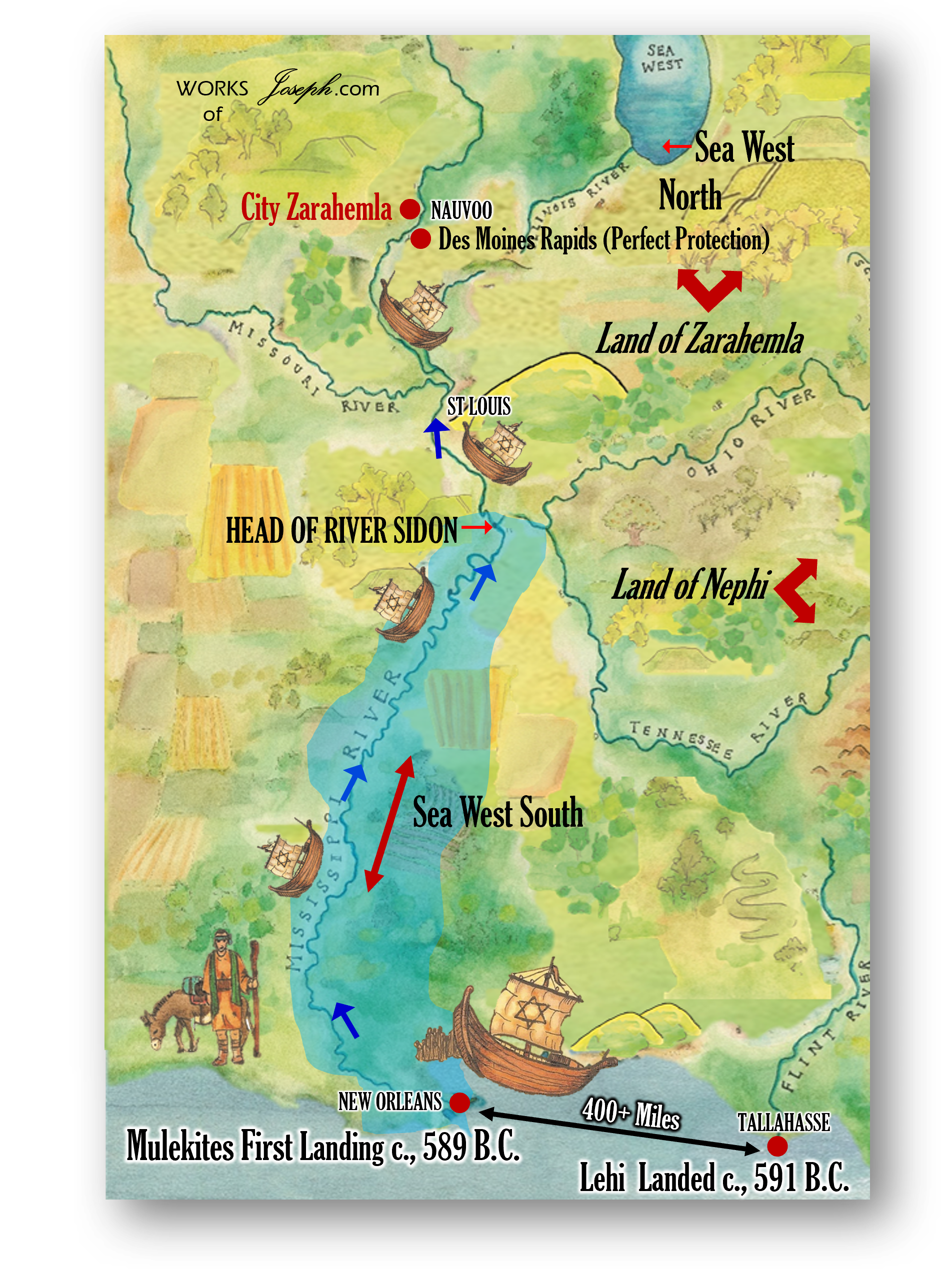
It shares two possible routes for the Mulekites in about 550 – 600 BC from Jerusalem to Zarahemla in the Book of Mormon time period. We at Firm Foundation feel confident that it is most likely the Mulekites traveled through the Mediterranean and south with the winds, right into the Gulf of Mexico and up the Mississippi River where they were forced to stop because of the Des Moines River Rapids near Keokuk, IA. A perfect place to begin the main Mulekite Civilization in the New World. Mosiah would find them later in about 329 BC.
Possible Routes Suggested for Mulek’s Voyage
by Dr. and Sister Ross T. Christensen
Two possible routes of the voyage of Mulek and his followers to the New World “promised land” of the Book of Mormon have been proposed by Dr. and Sister Ross T. Christensen of Brigham Young University. Dr. Christensen is a professor of archaeology and anthropology; his wife is a graduate student in archaeology.
The Book of Mormon does not specify whether the Mulekites made their voyage to the Americas in the sixth century B.C. westward across the Atlantic Ocean or eastward across the Pacific. But since that history clearly indicates that they landed on the east coast of the “land northward,” the Christensen’s suggest that the Mulekites may have followed the Atlantic route.
A study of Atlantic Ocean currents together with other substantive information supports the feasibility of two possible routes that these early voyagers might have taken, according to the Christensen’s. One is a Mediterranean and North Atlantic route; the other is around Africa, then across the South Atlantic.
The sixth century before Christ was a time of extraordinary activity in exploration, trade, and colonization in the Mediterranean world and beyond. And the destruction of Jerusalem and the flight of Mulek and his people and others who were oppressed only accelerated a disposition to emigrate. Israelite colonies are believed to have existed at Cyprus, Crete, Libya, Jerba, and Carthage at the time of Jerusalem’s fall, some of them having been established, according to tradition, during the reigns of David and Solomon. Also dating from the period of David and Solomon was a tradition of Israelite commerce with the Phoenicians.
One hypothesis suggests that at least part of the colony that settled in America with Mulek was Phoenician, because the river Sidon, mentioned in the Book of Mormon, bears the name of the principal city of ancient Phoenicia, Sidon. Aided by Phoenician mariners and Hebrew colonists across the Mediterranean, Mulek’s group could have reached the Atlantic Ocean by traveling the length of the Mediterranean Sea. Once out on the Atlantic, Mulek would have entered into a powerful ocean current that sweeps southwestward from Spain and Portugal along the west coast of Africa, then veers westward across the Atlantic, continuing in an arc through the West Indies.
While the Christensen’s believe Mulek traveled this more direct route across the Atlantic, they have also considered the route around Africa and across the South Atlantic as another possibility.
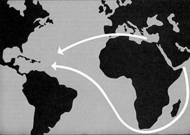
A powerful ocean stream originates in the Indian Ocean in the vicinity of Madagascar, sweeps southward around the Cape of Good Hope, veers westward across the South Atlantic to a point on the north of the eastern tip of Brazil, and continues northward off the coast of South America until it merges with the current flowing across the North Atlantic. Thus, if a vessel were to embark on the Red Sea and hold course close to the eastern shore of Africa until it reached the vicinity of Madagascar, it could follow the currents to the West Indies and the Gulf of Mexico.
Although twice as far as the Mediterranean route, this second possibility warrants consideration. It has been discovered that under orders of the Egyptian monarch Neccho II, Phoenician sailors in about 600 B.C. voyaged around the entire continent of Africa, and this was 2100 years before the same feat was accomplished by Vasco de Gama in 1498.
Another accomplishment about the time of the Mulekite voyage was an actual crossing of the Atlantic to America by Phoenician mariners who set sail in the Red Sea, taking the route around the Cape of Good Hope and across the South Atlantic to what is now Brazil. An ancient Phoenician inscription found at Paraiba, Brazil, sets the crossing between 534 and 531 B.C. https://www.churchofjesuschrist.org/study/ensign/1973/09/discovery/possible-routes-suggested-for-muleks-voyage?lang=eng
Lehi’s Route
This second route that the Christensen’s think is a possible Mulek route, I definitely feel it is more likely a route for Lehi in 600 BC. Firm Foundation has been promoting this route for Lehi for many years now.
I believe the Book of Mormon Events began in North America as many prophets and leaders have taught. There are Lamanites in North, South, and Central America through migration, intermarriage and other circumstances. However, through much study research, time, and prayer it makes most sense to me that Lehi landed in Florida and Nephi leaving his brethren, ended up in northern Georgia and Tennessee. Mosiah left Tennessee and went to Iowa and Illinois to join the Mulekites who were already in those areas.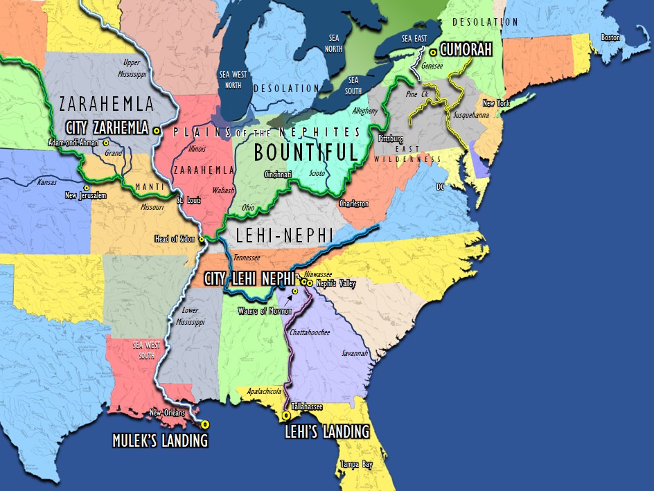
I feel it is very likely that the Mulekites came up the Mississippi River. The main reason I feel that way, is it says in Omni, the Mulekites had been the same place where Mosiah found them the entire time. “There”, in Onmi, would be defined as near the Mississippi River somewhere between Keokuk, IA and Montrose, IA where we feel the Land of Zarahemla is located.
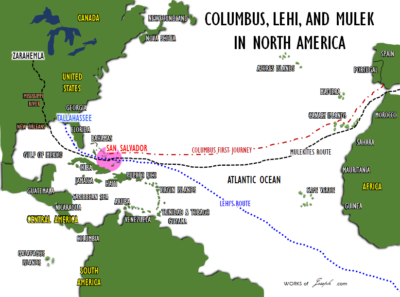
You can also see the similar paths the Lord may have brought Columbus, Lehi, and Mulek on the map below. All three would have a similar direction through the Bahamas. It makes sense to me.
15 Behold, it came to pass that Mosiah discovered that the people of came out from Jerusalem at the time that , king of Judah, was carried away captive into Babylon.
16 And they in the wilderness, and were brought by the hand of the Lord across the great waters, into the land where Mosiah discovered them; and they had dwelt there from that time forth.
17 And at the time that Mosiah discovered them, they had become exceedingly numerous. Nevertheless, they had had many wars and serious contentions, and had fallen by the sword from time to time; and their had become corrupted; and they had brought no with them; and they denied the being of their Creator; and Mosiah, nor the people of Mosiah, could understand them.” Omni 1:15-17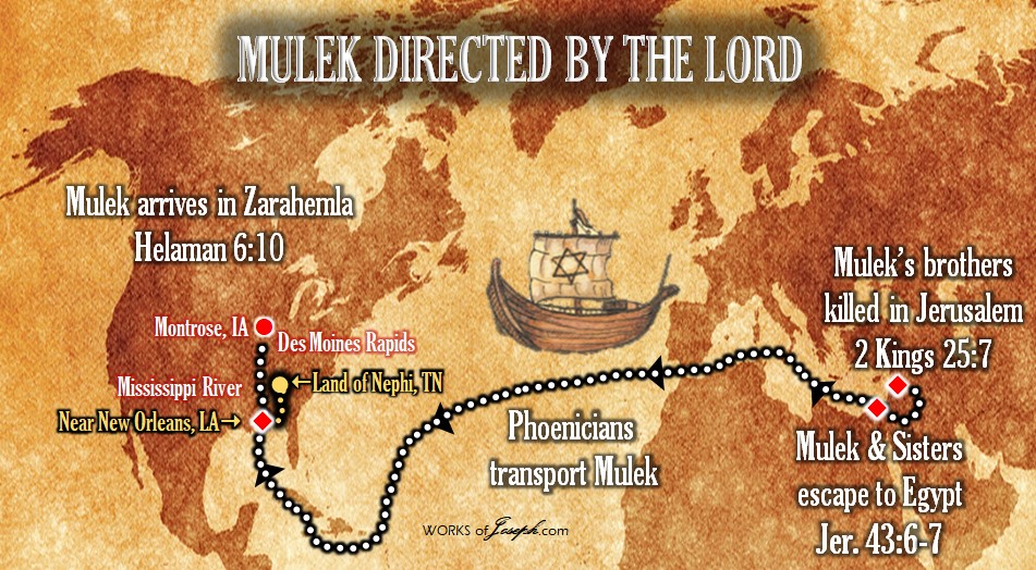
Because they had become numerous, I am confident there would have been people all up and down the Mississippi from New Orleans and above into Wisconsin and Minnesota. Groups who fight and flee would always find an area where they could live in peace.
“And they gave an account of one , and the slain of his people. And Coriantumr was discovered by the people of Zarahemla; and he dwelt with them for the space of nine moons.” Omni 1:21
After Coriantumr was injured near Ramah [Cumorah] in New York, he would probably find a close river with a boat to get away, and have time to heal. All around Coriantumur would be the Genesee River that runs north to Lake Ontario, the Susquehanna River that runs south east to the Atlantic Ocean, and the Allegheny/Ohio River that runs south west to the confluence of the Ohio with the Mississippi River. This is all the Land of Zarahemla as you see in the map below in shaded yellow. Any where along these rivers Mosiah and his people could have discovered Coriantumr, including up to Nauvoo where the City of Zarahemla was.
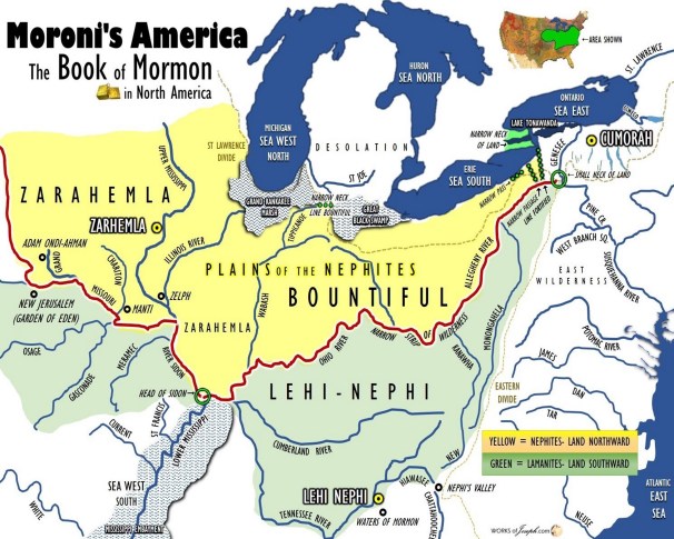
Since the land of Zarahemla as all along the northern part of the Ohio river and all around the Mississippi River Coriantumr’s boat could have been.
As my friend Wayne May suggests, the Mulekites may have taken the St Lawrence northern route and followed the Great Lakes toward Detroit and ending up in Iowa. I just feel that would be a difficult route with the harsh flowing direction of the St Lawrence, the barrier of Niagara Falls, and not having a direct route from Detroit to Iowa on the Mississippi. It seems to me they would have had to stop several places along the way.
The Phoenicia Ship voyage of 2020 by Captain Philip Beale went from Tunisia through the Mediterranean then south to Florida, landing in Puerto Rico and then onto Miami shown on the map below: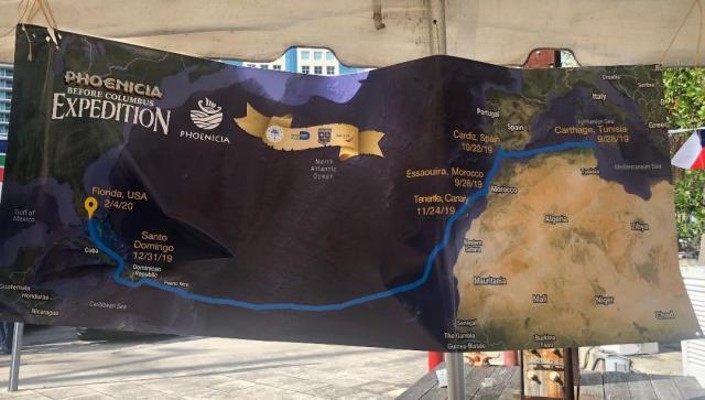
In Dec 2021 I sent the following email to Captain Beale:
Hi Philip:
I need your professional opinion as a navigator and ship Captain.
What are the advantages and disadvantages of a 600 BC ship to sail to Nauvoo, Illinois, USA.
We have two suggested paths and I would like a short answer of which pathway to Illinois would be most likely and why.
1. From Tunisia across the Atlantic similar to the path you took in 2020. Instead of landing on the East Coast of Florida the ship would continue around Miami and travel up the Mississippi River and stop in Illinois USA and Nauvoo?
2. Or from Tunisia going through Gibraltar and entering the St Lawrence Seaway following the Great Lakes through Lake Ontario Lake, Erie through Lake Michigan then taking the Mississippi River south to Nauvoo Illinois?
I am just looking for a basic decision based on the information you have now, with a most likely scenario.
Thanks for your suggestion.
Captain Beale answered me with an email that said the following.
Hi Rian,
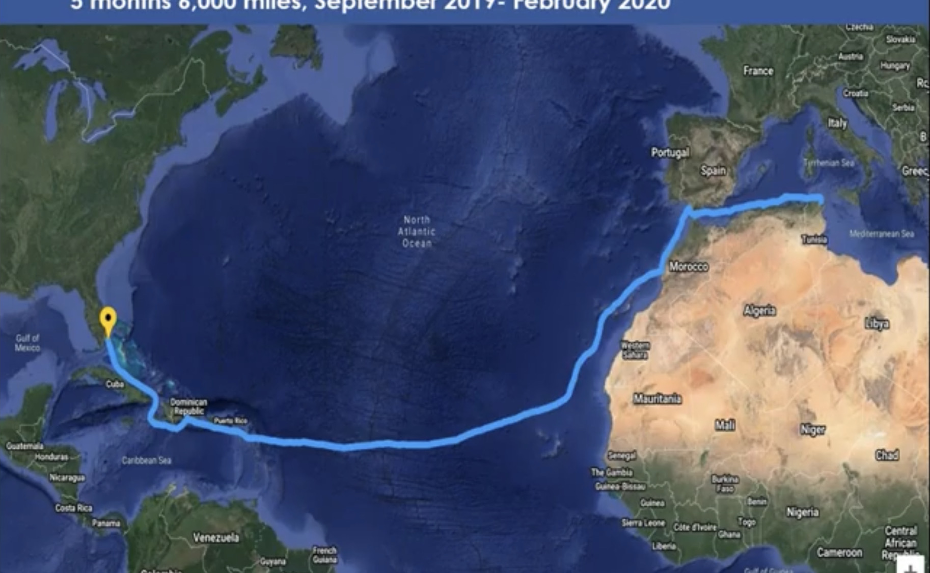
It is fairly straight forward I think.. the southern route is by far the easiest because of the prevailing winds and currents.
If you look at the Gulf stream that was first identified by Benjamin Franklin… from the Med. to the Caribbean is a simple conveyer belt.(See Map Below)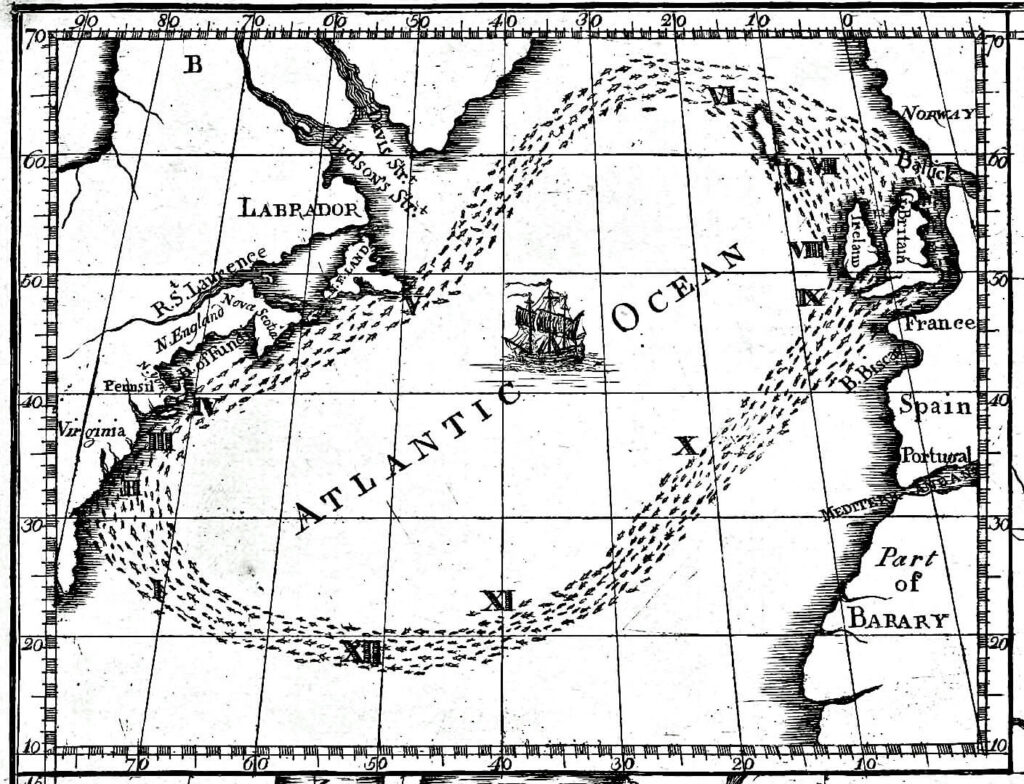
The winds and current are pretty much in synch most of the year and in the north north Atlantic the prevailing winds are West to East.. so very difficult for the Phoenicians to have gone the northern route.
Hope that helps. Philip Beale
Tickets to see the Speakers Here