Please watch Stephen’s video from out last Virtual Conference in April 2021. Login and do a search for his name and you will find it. bookofmormonevidencestreaming.com PRESENTATION: “THE TWO-CUMORAH SOLUTION”
As an Analyst for an International Bank for the past eleven years, Steve has a penchant for solving problems.
He doesn’t accept the current dogma by Book of Mormon Scholars, despite their advanced degrees, claiming that the Prophet Joseph Smith learned the geography of The Book of Mormon from a travel book with pictures, published in 1842 by John Lloyd Stephens.
(A travel book with pictures? Seriously? Is that the best analysis you’ve got?)
Then Book of Mormon geography miraculously turned into a restricted Mesoamerica setting with the original Hill Cumorah, not in New York, but located somewhere in Central America.
Below his information is amazing and will shed a new light on where the original 2-Cumorah Theory came from! His references are solid and you will enjoy his fantastic wit and sense of humor. Email him as he is very happy to speak about all the research he has done. [email protected].
The Origin of the Two Cumorah Mesoamerica Geography Theory for The Book of Mormon by Stephen Reed Mesa, AZ
I’ll be blunt. The so-called Two Cumorah Mesoamerica Geography Theory for The Book of Mormon, is completely false. There’s no truth to it.
Most people today promoting it, act is if they know nothing of its origin. And the ones who do, are hiding the truth of it. Shame on them.
Coined M2C, by Brother Jonathan Neville, for “Mesoamerica Two Cumorahs,” it was actually created in a house by its owner, located at 201 S. Willis Ave. in Independence, Missouri. Don’t believe me? Read on and learn.
The Two Cumorah idea was actually contrived separately and earlier than the restricted Mesoamerica Geography Theory.

As early as 1901, members of The Reorganized Church of Jesus Christ of Latter-day Saints (RLDS Church) were debating the location of The Hill Cumorah. This is found in “Autumn Leaves” a publication for the youth. This is a mere 57 years after the death of The Prophet Joseph Smith!
This is a screen shot from page 474 from that 1901 publication found at HathiTrust:
https://babel.hathitrust.org/cgi/pt?id=iau.31858045096413&view=2up&seq=502&q1=Cumorah
Note the name, H.A. Stebbins. It will be mentioned later.
To paraphrase, “Resolved, our present maps are correct. But many expressed themselves surprised at the evidence the negative side could show, that Cumorah being in New York is not correct.”
Well, that’s interesting. RLDS Members in 1901 debating the location of The Hill Cumorah on their maps. What maps are these?
The six maps created by the RLDS Committee on American Archaeology. Here’s Map No. 5 of the six maps.

Notice how the Land of Zarahemla is placed in the country of Colombia along the north-flowing Rio Magdalena as the River Sidon. The Hill Cumorah is correctly placed in upstate New York. This posed a problem for RLDS students of The Book of Mormon. The ones who actually studied the Book.
The distance was too far for King Limhi’s “rescue party” looking for the Land of Zarahemla. These Nephites somehow left the Land of Nephi (in Ecuador and Peru) and as they moved northward, they completely missed locating Zarahemla (in Colombia), entered the Isthmus of Darién or Panama, then traveled the length of Central America and Mexico then the breadth of North America. Then they discovered in upstate New York the Prophet Ether’s 24-gold plates, retrieving them and some oversized armor and rusted swords.
On their return trip, they again traveled the breadth of North America and the length of Central America, again missing the land of Zarahemla and arrived back at the Land of Nephi, where they were corralled by Lamanites. “To my mind it is very unlikely.”
So wrote RLDS Member A.B. Hanson in the earlier 1900 Autumn Leaves:


Of course, he was intelligent enough to mention the unlikely possibility of the Jaredite Coriantumr, wounded, of having traveled from upstate New York to Colombia to meet up with the people of Mulek only to live with them for nine moons. Hanson then demanded answers from RLDS Book of Mormon scholars.
These maps were so popular they were created as wall hangings, hung in homes and used for class lectures. “Map Lectures” are mentioned in “Autumn Leaves.”
This one recently sold at Boston Rare Maps, and has the address of 100 S. Willis written in the lower right corner. “Keep Dry.” They were made of cloth. Essentially, a wall rug.

What was the solution? Well, the First Quorum of Seventy of The RLDS Church convened a meeting. The first item on the agenda was, “Where is the Hill Cumorah?” by A. B. Phillips. Then a discussion on Archaeology and The Book of Mormon. This was announced in the RLDS publication, The Saints’ Herald of March 8, 1911.
Notice who was in attendance, L.E. Hills. Remember that name, please, as well as the earlier name of H.A. Stebbins. The location of the meeting was to be announced on the bulletin board in the church building. This was not a large group of RLDS members folks. It never rivaled the membership of The Church of Jesus Christ of Latter-day Saints, located in Utah.


Then this article, the entirety can be read in The Saint’s Herald of March 15, 1911, written by H.A. Stebbins and on my blog. To save space here, this is only the first page.
Thus, was introduced, what I call “The Two Cumorah Solution.” Notice that the Prophet Joseph Smith had nothing to do with it. This is 1911, now 67 years after his death.
Within a span of a lifetime after The Prophet’s death, some fellow believers in The Book of Mormon in Independence, were confused as to the location of The Hill Cumorah, because of improperly created hemispheric maps, for The Book of Mormon.

But why did H.A. Stebbins, who was involved with the earlier debate on the location of Cumorah in the basement of the Lamoni, Iowa church building in 1901, write this article some seven days after the announced March 8, 1911 meeting of the First Quorum of Seventy?
It’s because H.A. Stebbins’ February 1896 Book of Mormon lectures given in The Stone Church in Independence, was the “trigger” for the creation the RLDS “Committee on American Archaeology” in the April 1896 RLDS General Conference meeting. Stebbins’ lectures were very popular. They are available online today.
In his lectures, Stebbins placed The Book of Mormon in Mexico, and in Central and South America. The Committee’s maps were based off of his lectures as well as his other writings as early as the 1870s, which I won’t link to here. He was born in January of 1844, in Ohio, five months before the death of Joseph Smith and joined the RLDS Church in 1863 after returning from the Civil War.
Instead of suggesting the maps were wrong, Stebbins decided it was better just to move the original Hill Cumorah to Central America. Then he came up with the idea that the Prophet Moroni, the last Nephite survivor, traveled from Central America to New York with the gold plates. (Apparently, the Sierra Madres of Mexico and the Rocky Mountains weren’t a good place to bury the plates. Instead, after travelling thousands of miles, a tiny hill in upstate New York sufficed.)
This, Dear Reader, is how the Two Cumorah theory came about. Read his three-and-half page article on my blog or in The Saint’s Herald, and you’ll notice the same arguments being used today, by purveyors of M2C.
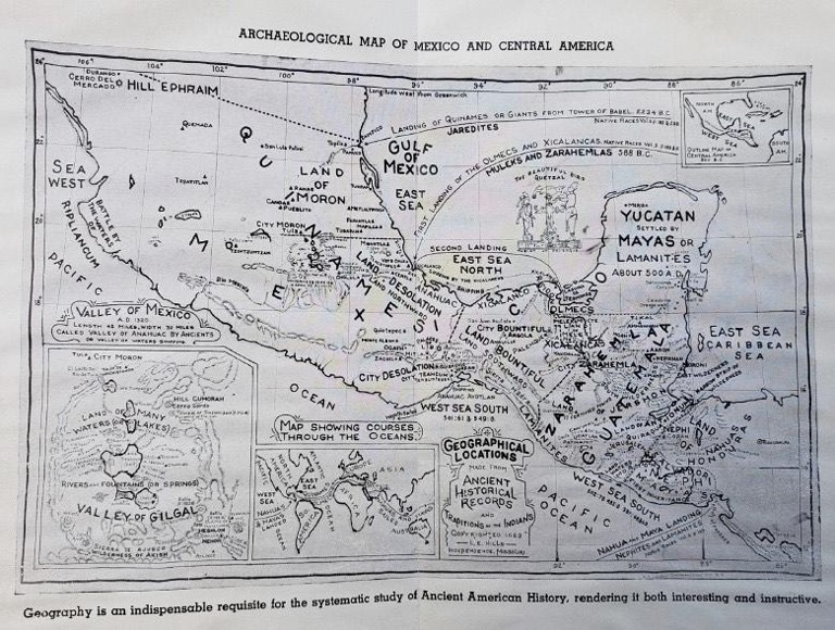
So how did the Mesoamerica version come to be? That was created by L.E. Hills. Do you remember that name? He was a member of the First Quorum of The Seventy.
He created three maps and wrote three books on the subject in his home at 201 S. Willis. Here they are below.
Maps: 1917, 1919, 1923.
Books: 1918, 1919, 1924
Look familiar? They should.
L.E. Hills died in 1925 after being struck by an automobile. His copyrights are expired and his works are in the Public Domain. Thus, anyone can resell them. And anyone has. And you’ve been duped!
In his 1924 book, Hills referred back to the Two Cumorah idea and H.A. Stebbins March 15, 1911 article. In fact, Hills wrote in his book, that Stebbins sent him that article published 13 years earlier. Stebbins approved of Hills’ ideas before Stebbins died in 1920. He never saw Hills’ 1924 book.
Thus, Henry A. Stebbins created “2C” or Two Cumorah. Louise E. Hills added “M” for Mesoamerica. And M2C was born, as early as 1917.
And you’ve been sold snake-oil by modern-day LDS Book of Mormon Scholars and BYU Professors, to place in your Lamp of Testimony. How’s that now working out for you?
I will end my message here. I have a lot more of this history that I could share. But I don’t want to bore any reader of this blog. If anyone wants me to continue with more information, contact Bro. Rian Nelson, the owner of this blog, who I thank for inviting me here.
Thank you,
Stephen Reed
Steve is a member of The Church of Jesus Christ of Latter-day Saints, residing in Mesa, Arizona. He is a nobody. That is, neither famous nor popular. But he has access to The Internet where he discovered all of this information.
And you can too, from the clutches of the Censors at Book of Mormon Central and The Interpreter Foundation, which are the remnants of F.A.R.M.S. (as well as FAIRLDS and their other affiliates) and who resold L.E. Hills’ works and maps, without attributing Louise Edward Hills as their source. Nor Henry A. Stebbins.
You can learn more by visiting his simple blog at https://twocumorahsolution.blogspot.com It’s free. And you won’t be insulted with PayPal buttons on every page, begging for donations.
——–//——–
The Three books and Maps by L.E Hills All Three Books are at HathiTrust, scanned by Google
1918: A SHORT WORK ON THE POPOL VUH AND THE TRADITIONAL HISTORY OF THE ANCIENT AMERICANS BY IXT-LIL-XOCHITL
1919: HISTORICAL DATA FROM Ancient Records and Ruins OF Mexico AND Central America
1924: NEW LIGHT ON AMERICAN ARCHAEOLOGY