
To me a huge witness is that the River Sidon or Mississippi River, was not only navigable for the Nephites in about 74 BC, but also for Joseph Smith in 1841. An amazing coincidence at the same location.
If the Mississippi River is the River Sidon as mentioned in the Book of Mormon, [which I believe it is], how could the battles in Alma 2 and Alma 43-44 speak about how easily the Nephites and Lamanites could cross that huge Mississippi River on foot?
Did you know that during Joseph Smith’s time, the Mississippi River was crossed on horseback by Joseph, and could be crossed by walking in some parts as well? The Des Moines River Rapids just south of Nauvoo was an obstacle where ships could not navigate that area until the Army Corp of Engineers cut a path so boats could then navigate that river.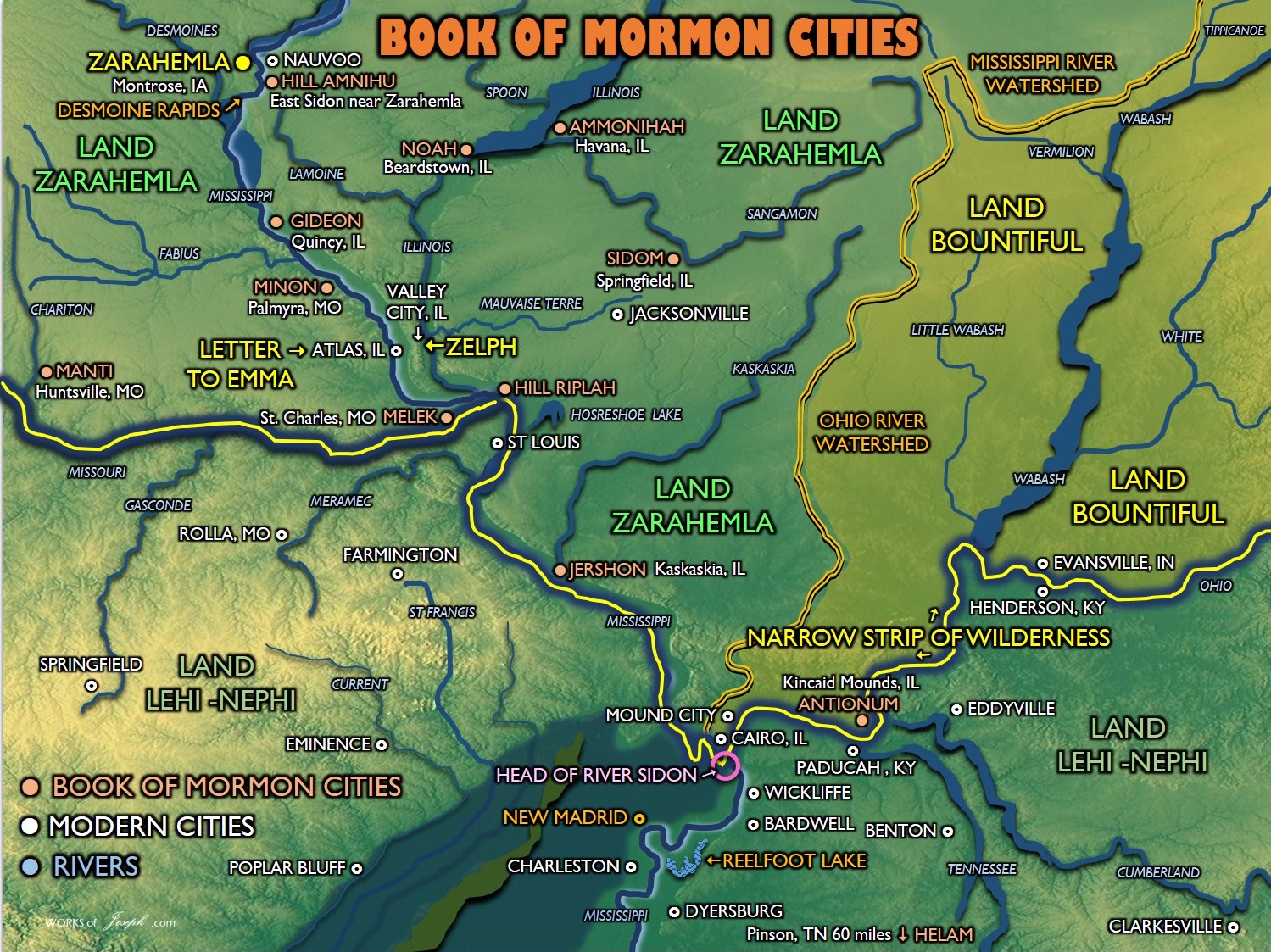
I believe it was at the Des Moines rapids, that stopped the Mulekites from traveling further up to Nauvoo, on the Mississippi River from the Gulf of Mexico. As it says in Omni 1:16, “And they [Mulekites] in the wilderness, and were brought by the hand of the Lord across the great waters, into the land where Mosiah discovered them; and they had dwelt there from that time forth. It seems that very place at the Des Moines Rapids, the Mulekites would have to had stopped, and then on foot [or portage] walked just north of there to Nauvoo and Montrose, Iowa, where they were found by Mosiah in about 300 BC. Detailed blog here: https://bookofmormonevidence.org/suggested-routes-of-the-mulekites/
Making the Mississippi River Navigable
“Various attempts to make the river navigable started in 1837 when a channel was blasted through the rapids by U.S. Army Corps of Engineers team led by Robert E. Lee. A canal around the rapids was built in 1877. It is now obliterated by Lock and Dam No. 19.” Wikepedia
Open your Annotated Book of Mormon to page 293, or open your regular Book of Mormon to Alma 43. As you read you can follow the action from the map below. The Mississippi River is the River Sidon and the action takes place just north of the current city of St. Louis, MO.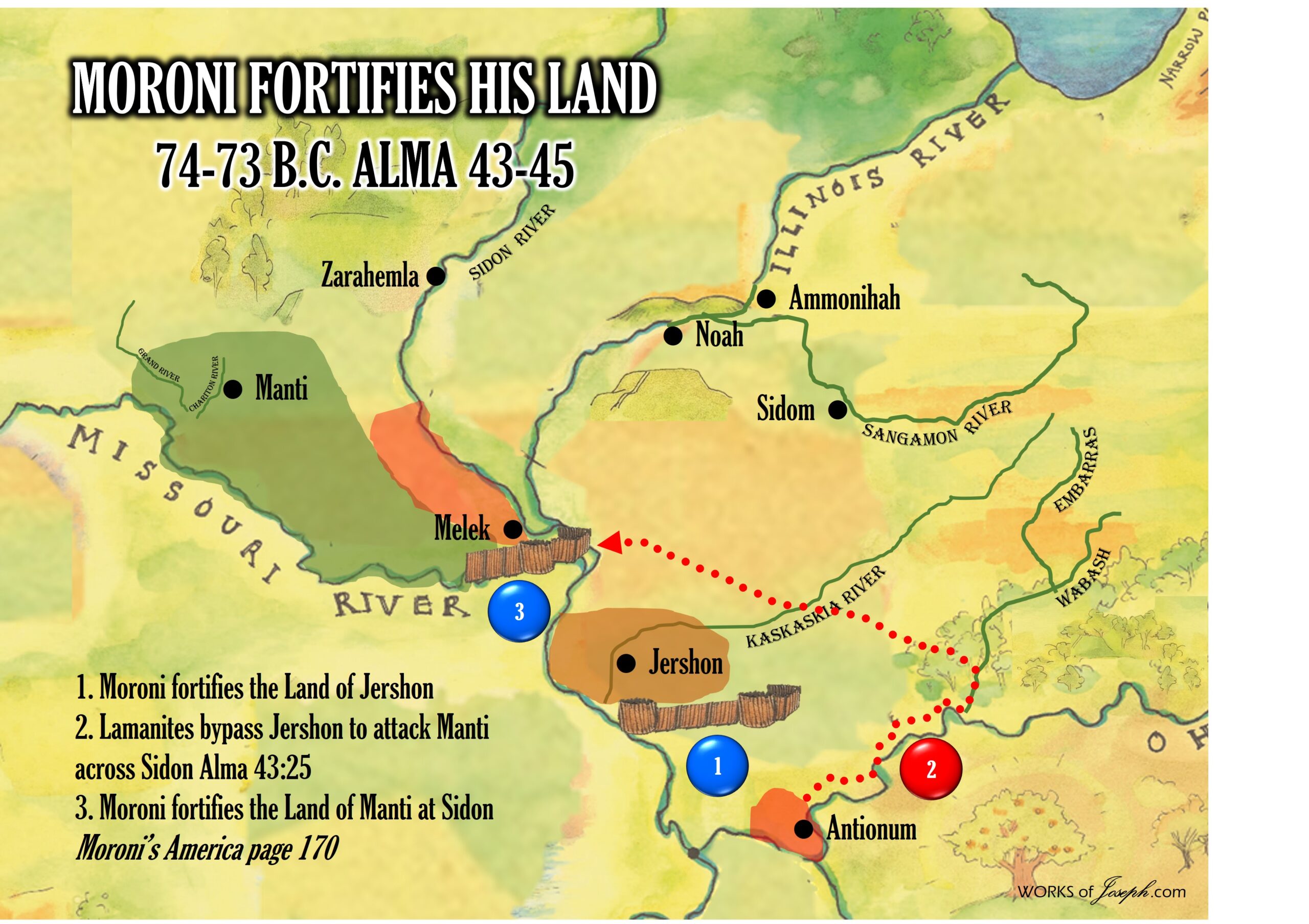
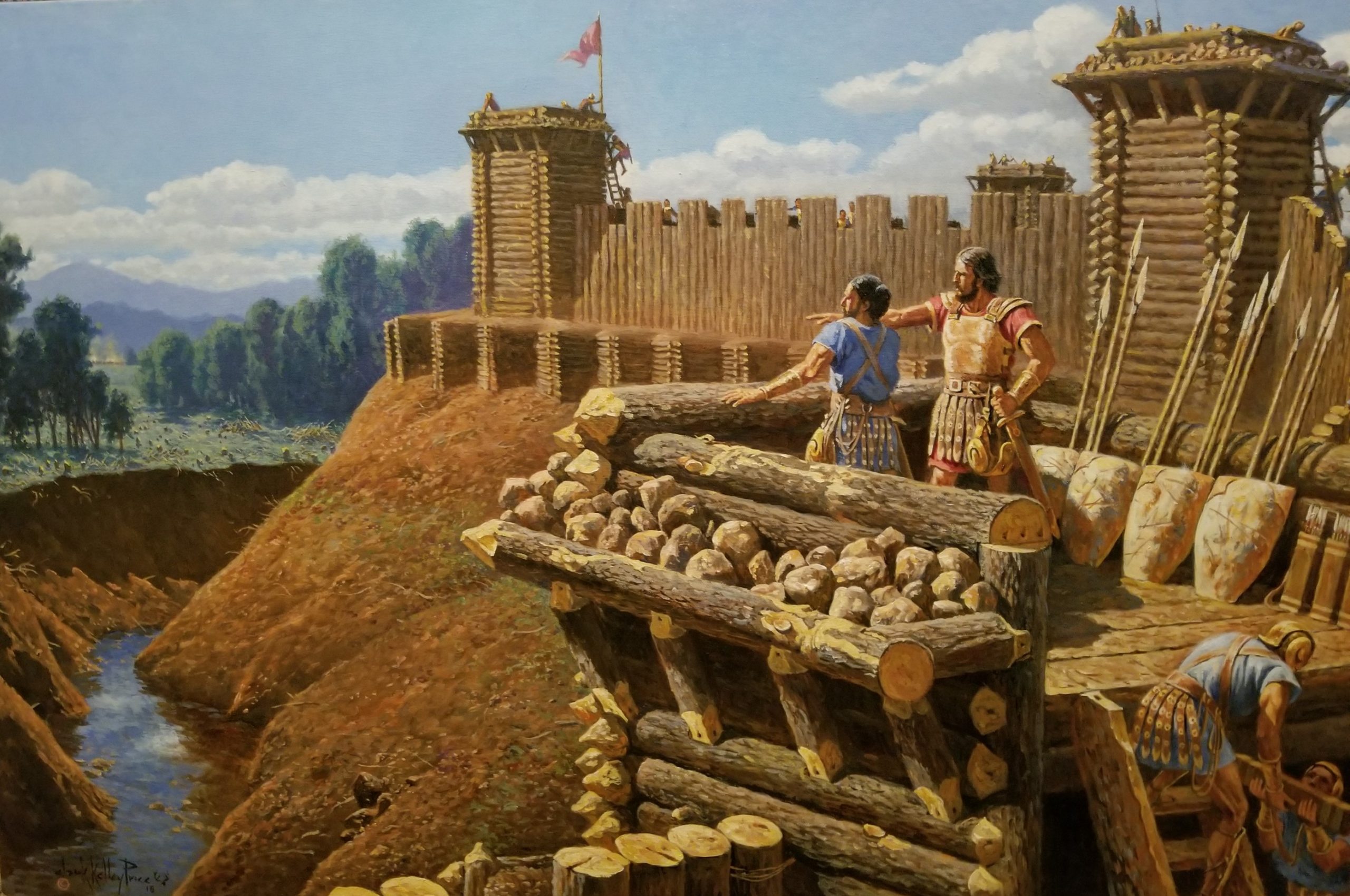
Cast their Dead into the River Sidon
20 And it came to pass that Moroni caused that the work of death should again among the people. And he took the weapons of war from the Lamanites; and after they had entered into a with him of peace they were suffered to depart into the wilderness.
21 Now the number of their dead was not numbered because of the greatness of the number; yea, the number of their dead was exceedingly great, both on the Nephites and on the Lamanites.
22 And it came to pass that they did cast their dead into the waters of Sidon, and they have gone forth and are buried in the depths of the . “Alma 44:20-22

The information below is from Jonathan Neville’s best selling book, “Moroni’s America”
“Chapter 43 resumes the account of the wars between the Nephites and the Lamanites. The Nephites gathered their armies in the land of Jershon, while the Lamanites came into the land of Antionum. All the leaders of the Lamanites were Amlicites (Amalekites) and Zoramites.
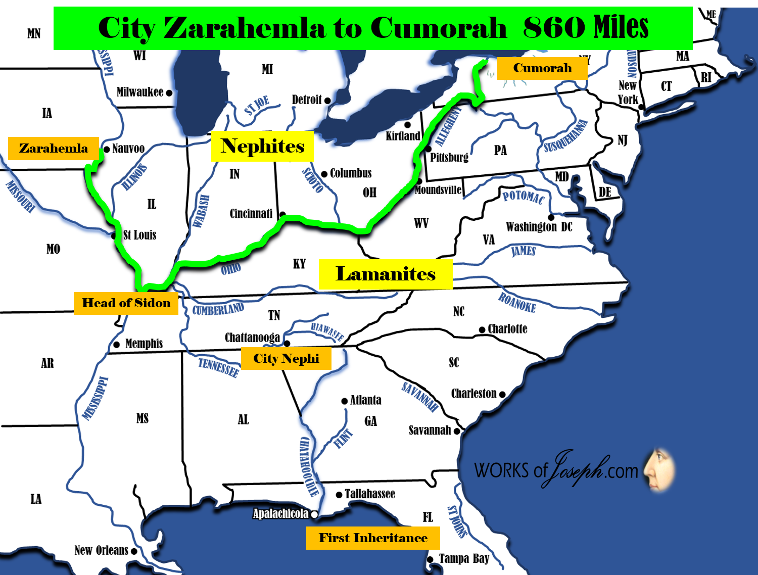
Captain Moroni met the Lamanites “in the borders of Jershon” (Alma 43:18), but when the Lamanites saw that the Nephites were better armed and protected with breastplates and arm-shields and thick clothing, their leaders “departed out of the land of Antionum into the wilderness, and took their journey round about in the wilderness, away by the head of the river Sidon, that they might come into the land of Manti and take possession of the land” (Alma 43:25). [The Head of River Sidon is most likely the confluence of the Mississippi River and the Ohio River]
From the Lamanite perspective, this made sense. Moroni had fortified the land of Jershon, and presumably the sea, or mighty river, it bordered. The Lamanites could do an end run around Jershon, past the productive (bountiful) farmland into the wilderness north, and then cross the Sidon to reach Manti.
The confrontation between Moroni and the Lamanites is another battle in and near the river. Moroni “found by his spies which course the Lamanites were to take” (Alma 43:30).
31 Therefore, he divided his army and brought a part over into the valley, and concealed them on the east, and on the south of the hill Riplah; [See #5, in map above]
32 And the remainder he concealed in the west valley, on the west of the river Sidon, and so down into the borders of the land Manti. [See #4, in map above].
33 And thus having placed his army according to his desire, he was prepared to meet them.
34 And it came to pass that the Lamanites came up on the north of the hill, where a part of the army of Moroni was concealed.[See #4 on the map above].
35 And as the Lamanites had passed the hill Riplah, and came into the valley, and began to cross the river Sidon, the army which was concealed on the south of the hill, which was led by a man whose name was Lehi, and he led his army forth and encircled the Lamanites about on the east in their rear.
36 And it came to pass that the Lamanites, when they saw the Nephites coming upon them in their rear, turned them about and began to contend with the army of Lehi.
The Nephites were better armed and protected, so “the Lamanites became frightened because of the great destruction among them even until they began to flee towards the river Sidon… and they were driven by Lehi into the waters of Sidon and Lehi retained his armies upon the bank of the river Sidon that they should not cross” (Alma 43:39-40).
Moroni had stationed the rest of his army “in the valley on the other side of the river Sidon” (Alma 43:41). When his men began to “fall upon” the Lamanites and to slay them, “the Lamanites did flee again before them towards the land of Manti and they were met again by the armies of Moroni” (Alma 43:41-2).
All of this was taking place near the “head of Sidon,” because that is where the Lamanites planned to attack.
The passage describes a river that is a significant barrier, with a hill and bank on the east side and a large valley on the west side. Armies can cross it (at least at some times of the year), but it is a significant barrier. This cannot be “headwaters” as some commentators have proposed. [It is a confluence where the Mississippi meets the Ohio]
Another requirement: there must be a way out of the valley toward the land of Manti.
One place that fits this description nicely is where the Missouri River meets the Mississippi. [Another possible Head of Sidon with the confluence of the Missouri and the Mississippi]. On the east bank, there are hills. The west bank is a wide valley, with access to the north and west toward what would have been the land of Manti.
At this point, the Lamanites were surrounded. Moroni offered a truce, but Zerahemnah, the Lamanite leader, refused to enter a covenant of peace. Moroni resumed the battle until “Zerahemnah, when he saw that they were all about to be destroyed, cried mightily unto Moroni, promising that he would covenant and also his people with them, if they would spare the remainder of their lives, that they would never come to war against them” (Alma 44:19).
As before with the Amlicites, “they did cast their dead into the waters of Sidon and they have gone forth and are buried in the depths of the sea” (Alma 44:22).” Moroni’s America by Jonathan Neville page 169-173
Crossable Mississippi River for the Nephites and Joseph Smith
“The Des Moines Rapids between Nauvoo, Illinois on the east and Montrose (Zarahemla) and Keokuk, Iowa on the west was formed by a hard natural limestone shelf that extended across an 11 mile stretch of the Mississippi river. It severely limited Steamboat traffic through the early 19th century. Prior to the building of locks and dams that have raised water levels 18-20 feet, it was the first location upstream from the Gulf of Mexico where the Mississippi river could be crossed… on foot. Historical records state that these rapids had an average depth of only 2.4 feet*, with most of the crossing being more shallow, especially during late summer, fall and dry seasons…
*”The Mississippi in its natural state widens from 2,500 feet (760 m) to 4,500 feet (1,400 m) in width at Nauvoo as it drops 22 feet (6.7 m) over 11 miles (18 km) over shallow limestone rocks to the confluence with Des Moines. According to records its mean depth through the rapids was 2.4 feet (0.73 m) and “much less” in many places.” Wikipedia
Rodney Meldrum continues, “…Why is this important? This would have been one of the most strategic locations in North America due to this crossing of a significant barrier to travel, the Mississippi River. Trade would also occur here bringing goods and people together from across the continent.
This location would also be of strategic importance in securing against foreign invasion. An ancient army would of necessity be faced with either swimming or rowing their men across to launch an attack, which in the case of the Book of Mormon could mean many thousands of men awaiting portage. The element of surprise in battle would be lost if a week were required to ferry men across the river. This major river crossing would, then, be a critical strategic location either to defend of to conquer, by allowing or restricting access to either side. Exploring the Book of Mormon in America’s Heartland by Rod Meldrum pg. 80-81
CROSSING THE MISSISSIPPI ON HORSEBACK
On August 8, 1842, a Warrant was served by Governor Carlin for the arrest of Joseph Smith and Porter Rockwell who had been charged with the near fatal shooting of Gov. Lilburn Boggs. Joseph and Porter went into hiding, knowing their innocence and that this was just another attempt to thwart the work of the Lord.
From Dean C. Jesse’s The Papers of Joseph Smith, in the Illinois journal we read from the entry Aug. 11th, “It is very evident that the whole business is but another evidence of the effects of prejudice, and that it proceeds from a persecuting spirit, the parties having signified their determination to have Joseph taken to Missouri whether by legal or illegal means.” The journal continued, “12 August 1842 – Friday – This AM it appears still more evident that the whole course of Proceedings of Gov. Carlin and others is illegal”
A stratagem was conceived to trick the Sheriff and his Deputies. The journal states,” Accordingly Joseph’s new horse which he rides, (which he named Joe Duncan after the unsupportive former Governor of Illinois) was got ready and Wm. Walker proceeded to cross the river in sight of a number of Persons. One chief design in this procedure was to draw the attention of the Sheriffs and public, away from all idea that Joseph was on the Nauvoo side of the river.”
The next day, “A report came over the river that there is a several small companies of men in Montrose, Nashville, Keokuk, etc., in search of Joseph. They saw his horse go down the river yesterday and was confident he was on that side.” The Mississippi River was shallow enough on this late summer day to ride a horse across it at this location.” Exploring the Book of Mormon in America’s Heartland by Rod Meldrum pg 80-81
More about Zarahemla
“I have a Patriarchal blessing hanging in a frame in my room, which was pronounced upon my head by the prophet and patriarch, Hyrum Smith, in the fall of 1844[1843?], which is worth more than gold to me – Gold is no name for it. The predictions are being literally fulfilled every day. I know if I prove faithful it will all come to pass. I knew then and also know now that Joseph was a true prophet of God, and that the mantle of Joseph fell on Brigham Young who was his legal successor.
I was present at the meeting when this took place and heard with my own ears and saw with my own eyes. We all thought Joseph had come back to us although we knew he was in his grave. I was standing by the temple talking to Brother Woodruff and he pointed out a spot to me on the opposit[e] side of the river about a mile and a half above Montrose, and said there would be a city and a temple built there and the place would be called Zarahemla. I was at Nauvoo when the temple was finished and dedicated. I went up into the tower and wrote my name there. As I understand, the wicked have burned that temple to the ground and it is all destroyed like the Jerusalem temple. But I expect to see that temple re-erected and the one built on the opposite side of the river to match.” Autobiography of Edward Phillips (1813-1896)