Nephite “Mann Site” Indiana 100-500 AD

1913

Nephite, Mann Site- Indiana

The Mann site is an archaeological site just east of Mount Vernon, Indiana. Though it looks like an ordinary farm field today, almost 2,000 years ago, Mann was a bustling center of trade, religious ceremony and settlement and was one of the most important places in the eastern U.S. The mounds at the Mann Site in Mt. Vernon, IN, are believed to have been built between A.D. 100 and 500. In comparison the Newark Earthworks in Newark Ohio, are dated from 100 BC to 100 AD the same timeline as the Nephites. You will also see the Angel Mounds in Evansville, IN which are the Mississippian culture which was after the Nephites were destroyed. Editors Note: The Mann Site in Mt Vernon, Indiana sits right on the Ohio River, just east of the confluence of the Wabash River. It is possible that the Wabash river separates the Land Bountiful from the Land Zarahemla all the way up to the Narrow Neck of Alma 63, where Hagoth sailed his ships. The Narrow Neck is also called the Line Bountiful which separates the Land Desolation from the Land Bountiful.

Over 200 Maps of Book of Mormon Lands. Excellent for FHE or Trips. Purchase Now!

Mann Hopewell Site Has More Ancient Artifacts Than Anywhere Else In Indiana

August 06, 2020 by Elizabeth Crozier Find a slew of ancient artifacts at a historic site in Mount Vernon, Indiana. Once used by Native Americans as a burial site, this place is now an archeological wonder.

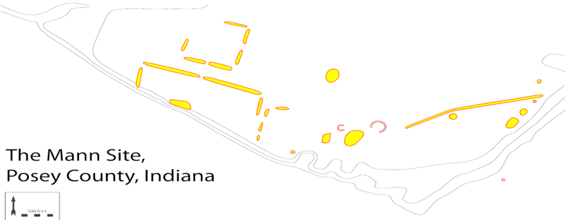
Where else in Indiana can you explore ancient artifacts? Share your favorite places with us below in the comments. For more like this, check out these five sacred Native American sites in Indiana that everyone should visit at least once.

Mann Site Video

 
Book of Mormon in North America

Book of Mormon Evidence.org believes The Book of Mormon events in the New World occurred in North America. The Church of Jesus Christ of Latter-day Saints is neutral on this subject. Our information is based on archaeology, anthropology, text of the Book of Mormon, distances, geology, and we believe the many rivers were the highways of the ancients including the Nephites. The article below from a Palmyra Newspaper will tell you about the battles near the Mann Site in Indiana and on the border of Illinois, which we have been discussing. Palmyra Register, 1818 says: “The author of this interesting and valuable work, in speaking of the antiquities of the state of Indiana that now exist near Vincennes, County of Knox, says that “On the hills, two miles east of the town, are three large mounds; and others are frequently met with on the prairies, and upland, from White River to the head of the Wabash. They are in every respect similar to those in Franklin County, already described. The French have a tradition, that an exterminating battle was fought in the beginning of the last century, on the ground where Fort Harrison now stands, between the Indians living on the Mississippi, and those of the Wabash. The bone of contention was the lands lying between those rivers, which both parties claimed. There were about 1000 warriors on each side. The condition of the fight was, that the victors should possess the lands in dispute. The grandeur of the prize was peculiarly calculated to inflame the ardor of savage minds. The contest commenced about sunrise. Both parties fought desperately. The Wabash warriors came off conquerors, having seven men left alive at sunset, and their adversaries but five. The mounds are still to be seen where it is said the slain were buried.” Palmyra Register, 21 January 1818 Extract from the Western Gazeteer.  This quote above could have been in reference to the many battles fought between the Lamanites and Nephites in this general area. (See Map Below) The area described in the article above is the area we would call the middle of the Land Zarahemla and the Land Bountiful with the Land Desolation being north of Bountiful. As a matter of fact, my maps show that the Wabash River could possibly be the division point of the Land Bountiful, east of the Wabash, and the Land Zarahemla west of the Wabash to the Mississippi River and beyond, to the Missouri River. That is the area of Lachoneus of the Book of Mormon and many other battles in Alma 2 and Alma 46. That area of Missouri to Illinois, to Indiana to Ohio to Pennsylvania were all the direction of the last great battle of the Book of Mormon ending at Cumorah.
The Black arrow above represents the division of the Land Bountiful and Land Zarahemla. Between the Mississippi River and the Wabash is where the quoted battle from the Palmyra Register occurred. Yellow shaded area is Zarahemla and shaded orange area is Bountiful.

There are 3 unique mentions in the Book of Mormon about NECKS!

  1. NARROW NECK OF LAND Ether 10:20
  2. NARROW NECK Alma 63:5 (This blog is about this Neck)
  3. SMALL NECK OF LAND Alma 22:32
More detail at my Narrow Neck blog here.