Origin of M2C
(Mesoamerican 2-Cumorah Theory)
In April 1917, RLDS scholar Louis E. Hills (occupation Railroad Conductor) of Independence, Missouri, published a map that depicted M2C, an abbreviation for the Mesoamerican Two Cumorah Geography Theory for The Book of Mormon. This theory is being heavily promoted today.
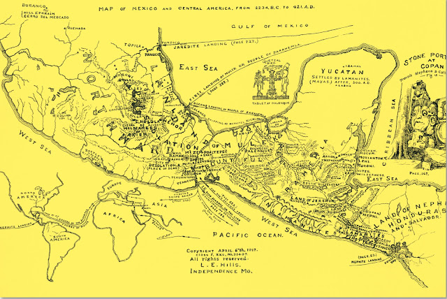
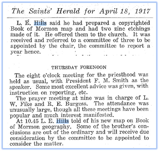
This standalone map is noted in “The Saints Herald” published April 18, 1917. It’s from a zinc etching or engraving with a Class F copyright, XXC, No. 31407. This Class F copyright is noted for engravings in 1917, by the US Copyright Office:
https://www.copyright.gov/historic-records/admin-classification.pdf
This 1917 copyrighted map should be a clear indication itself that the Prophet Joseph Smith, murdered with his brother Hyrum in 1844, was not involved with this M2C theory for The Book of Mormon.
This yellow map can be found in an online article at Book of Mormon Foundation, www.bomf.org located in Independence, Missouri:
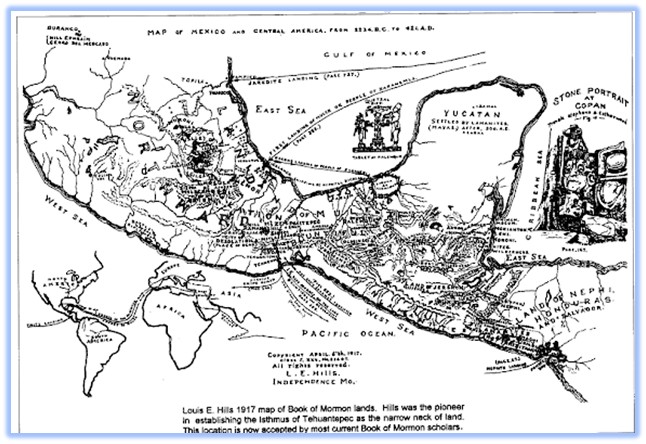
The same map in black and white can also be found at bomf.org in another online publication:
Both articles were written by Shirley Heater of BOMF in Missouri https://www.bomf.org/bmf-history.html. She passed in 2017.
Notice the caption at the bottom of the black and white version of the map:
“Louis E. Hills 1917 map of Book of Mormon lands. Hills was the pioneer in establishing the Isthmus of Tehuantepec as the narrow neck of land. This location is now accepted by most current Book of Mormon scholars.”
The LDS–RLDS Connection
“Book of Mormon Central,” in conjunction with “Interpreter Foundation” and “FAIRLatterDaySaints,” has been promoting this theory for decades, when the former two were known as F.A.R.M.S.
Book of Mormon Central reveals on its website that it has volunteers from Community of Christ and Restoration Branch.
Relationship of Book of Mormon Central to the Church of Jesus Christ of Latter-day Saints
“All BMC executives, board members, and employees are active, faithful, believing members of the Church of Jesus Christ of Latter-day Saints. Some of our volunteers are members of Community of Christ or Restoration Branch congregations.”
https://bookofmormoncentral.org/content/donor-frequently-asked-questions
One of these was Shirley Heater as noted at the Utah-based BMAF.org: http://www.bmaf.org/bio/shirley_heater
BMAF.org was acquired by Book of Mormon Central, as noted on its home page, http://www.bmaf.org
The RLDS History Preceding M2C
The history leading up to the Limited Geography Theory is intertwined with the history of The Reorganized Church.
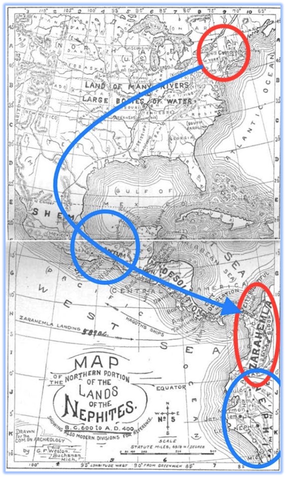
In 1894, The RLDS Church created a “Committee on American Archaeology” which published a 184-Page Report with hemispheric maps in defense of The Book of Mormon. It can be found on line here with its maps:
https://play.google.com/books/reader?id=PXYoAAAAYAAJ&pg=GBS.PP1&hl=en
This Church with its believers in The Book of Mormon, falsely assumed The Book of Mormon occurred in both North, Central and South America. This was contrary to the teachings of The Prophet Joseph Smith and the Prophet Ether both who indicated the Center Place of Zion is The New Jerusalem located near Independence, Missouri.
Central America was falsely assumed to be the “narrow neck” of land. Both the lands of Zarahemla and Nephi were placed in South America, the north flowing Rio Magdalena in Colombia as the River Sidon, but with Cumorah correctly located in New York.
These maps were official RLDS doctrine, published and given to members of the RLDS Church, which caused confusion – The Land of Nephi and the land of Zarahemla were too far from Cumorah in New York.
This was noted in published RLDS documents, today found online. Members wrote complaining that King Limhi’s rescue party of 43 men could have not traveled as far as upstate New York, located the Prophet Ether’s 24 gold plates near the Hill Ramah (Cumorah), then returned again all the way to the Land of Nephi in South America without again encountering the nearby Land of Zarahemla, also in South America.
These RLDS documents can be found on my blog at: https://twocumorahsolution.blogspot.com
Also, it made no sense to RLDS members that the last Jaredite King, the injured Coriantumr, traveled to South America to encounter the people of Mulek, to live with them for only “nine moons.”
“Drawn for The Committee on Archaeology”
The Two Cumorah Solution
In 1911, some RLDS members, specifically H.A. Stebbins, suggested a compromise, that the Hill Cumorah had to be located in Central America. Then they logically suggested that the Prophet Moroni, after the final battle, walked to New York with the gold plates and the Urim and Thummim and buried them in an obscure hill in New York.
This obscure hill near the Prophet’s home, they also suggested, later received the name Cumorah due to a tradition by the early LDS Saints to naturally call it that name. But that the actual Hill Cumorah is unknown and located somewhere in Central America.
This theory persists today among a group called the https://hillcumorahexpeditionteam.com
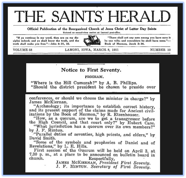
Louis E. Hills, as a member of the RLDS First Quorum of the Seventy, was in attendance in a 1911 meeting which discussed, “Where is the Hill Cumorah?” due to the confusion of the published hemispheric maps. This is noted in “The Saints Herald,” for March 8, 1911.
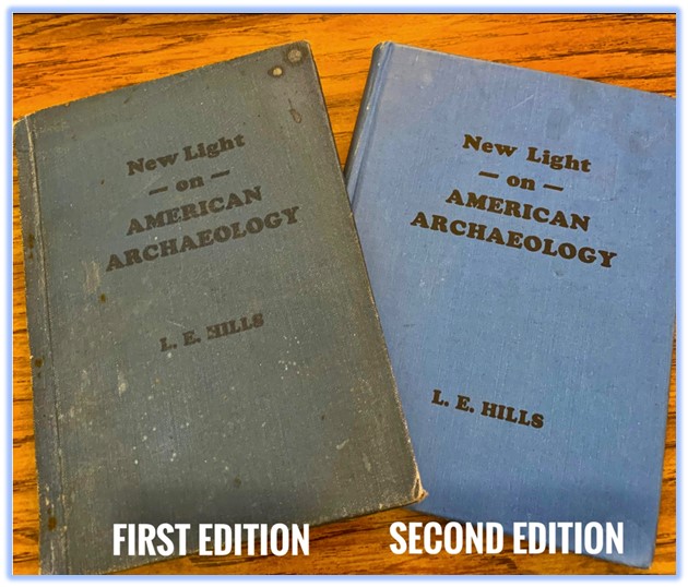
Six years later, in an attempt to help his Church, Hills introduced his 1917 limited Mesoamerican map (above) and wrote three books on the subject. His last book published in 1924 called, “New Light on American Archaeology” was in response to the RLDS Committee on American Archaeology. Hills died shortly after in 1925 from being struck by an automobile while walking near his home.
But his maps and books had been rejected by the RLDS First Presidency, also noted on my blog.
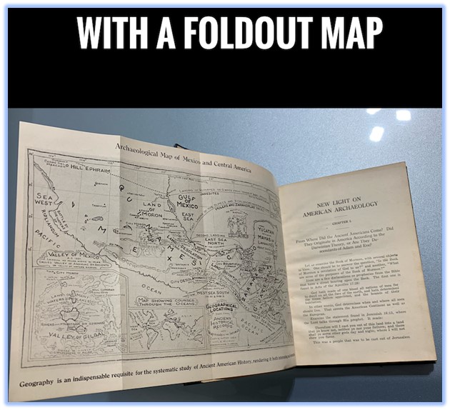
His three books survived and have been scanned by Google and are located on the website, Hathitrust.org. Below are shortened URLs to each. Each book has a map, except the scanned online version of the 1924 book.
But I recently found and purchased two copies on Amazon, one of them containing the fold out Mesoamerican map, being promoted today by LDS Scholars who belong to The Church of Jesus Christ of Latter-day Saints.
https://tinyurl.com/LEHills1918book
https://tinyurl.com/LEHills1919book
https://tinyurl.com/LEHills1924book
What is odd, is that due to LDS Scholars having heavily promoted this false M2C theory, The current Book of Mormon video of Moroni, has an actor portraying this last Nephite Prophet walking and aging as he goes, until some 30 years later, nearly bald and grey, he finally buries the gold plates and the Urim and Thummim. Imagine Moroni carrying around the heavy gold plates and the breastplate, for 30 years!
This is what is taught in the false M2C geography theory for The Book of Mormon, created and copyrighted by Louis E. Hills of Independence, Missouri.
Now if you were paying attention, you just learned why both a hemispheric and a limited Mesoamerican theory for The Book of Mormon, do not work. This leaves North America as the only correct working geography model for The Book of Mormon, as stated by The Prophet Joseph Smith. – Stephen Reed, Mesa, Arizona Stephen’s Blog: