
I am amazed at how many similarities there are between the two Promised Lands, the USA and Israel. Understanding both of these Promised Lands is a critical part of understanding the Gospel.
“The remarkable alliance between Israel and the United States has always been above politics. It must always remain above politics. Because America and Israel, we share a common destiny, the destiny of promised lands that cherish freedom and offer hope. Israel is grateful for the support of American — of America’s people…” Benjamin Netanyahu’s Speech to U.S. Congress MARCH 3, 2015
How Many Promised Lands Are There, When Were They Established, And Where Are They Located?
The First Recorded “Land of Promise” in Scripture
“The first recorded instance of a “land of promise” in scripture is a land called Cainan, named after a great-grandson of Father Adam (PGP Moses 6:17). Three years prior to his death, Adam called his righteous posterity together, specifically including Cainan by name, and gave them his last blessing in the valley of Adam-ondi-Ahman (D&C 107:53). Interestingly, the original or pre-flood “land of promise” was a land in the vicinity of Adam-ondi-Ahman which is known by modern revelation to be within the state of Missouri, USA (D&C 116:1).
Blessings of the Promised Land Covenant
Once Adams posterity rebelled against God, they were swept from this Promised Land by the the great flood. After the flood, Noah’s three sons, Ham, Shem, and Japeth, and their families dispersed from Turkey’s Mount Ararat into three regions roughly known as Egypt, Canaan and Asia respectively. Following their departure from righteousness, Abraham, a descendant of Shem, left his homeland of Canaan for Egypt for a time, returning again to the lands of his ancestors. Upon his return he was commanded to sacrifice that which was most precious to him, his son Isaac, on what today is Mount Moriah, or the temple mount of Old Jerusalem. Because of his unflinching obedience to God, Abraham was promised a land known as Canaan (Gen. 13:14-15, Abraham 2:18-19), which is present day Israel (see map), for his posterity, together with a covenant that as long as his children would keep His commandments, they would be blessed in the land by covenant.
This Promised Land Covenant included: (see overviews in Leviticus 26:1-9, Deut. 7:11-23, Deut. 28:1-13 )
- A Promised Land (a specific location), (see Genesis 13:14-15, 48:3-4, Abraham 2:18-19 )
- Posterity (seed), (see Genesis 13:16, 48:3-4, 1 Kings 2:3, 1 Chron. 22:13, D&C 132:30, Abr. 2:10-11 )
- Prosperity (wealth), (see 1 Kings 2:3, 1 Chron. 22:13, Leviticus 26:4 )
- Security (protection/peace) Leviticus 26:5-8, Ezekiel 28:26, 34:25, Isaiah 5:5 “hedge” of protection for Israel )” Rod Meldrum “The Scriptural Basis for Book of Mormon Geography ” Full article here:
Below is new information I just learned from a reader of this blog regarding what is a “Tel” in Israel, and how it compares to a “Mound” in the Heartland of North America. Fascinating information.
“Tel” in Israel “Mound” in North America
“In archaeology, a tell or tel (borrowed into English from Arabic: تَل, tall, ‘mound’ or ‘small hill’), is an artificial topographical feature, a species of mound[a] consisting of the stratified debris from the accumulated refuse of generations of people who once formed a settlement and dwelt on the same site. A classic tell looks like a low, truncated cone with sloping sides and a flat, mesa-like top. They can be more than 43 m (141 ft) high.

Tells are formed from a variety of remains, including organic and cultural refuse, collapsed mudbricks and other building materials, water-laid sediments, residues of biogenic and geochemical processes, and aeolian sediment. Tells are most commonly associated with the ancient Near East, but they are also found elsewhere, such as Southern Europe from Bulgaria to Greece[8] and in North Africa. Within the Near East, they are concentrated in less arid regions, including Upper Mesopotamia, the Southern Levant, Anatolia and Iran, which had more continuous settlement. Wikipedia

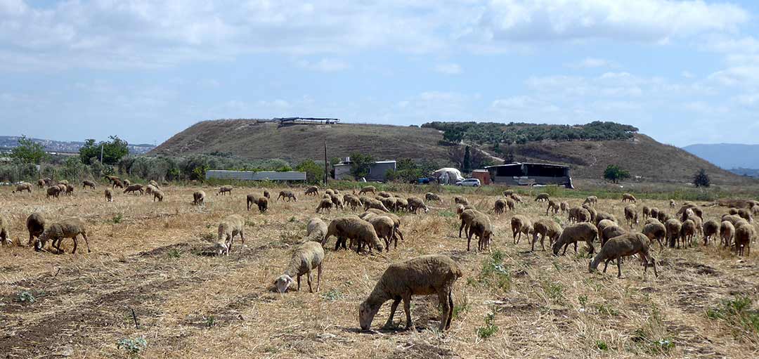
Ruins of a Biblical city on a hill on the western end of Kziv creek. The site existed until the Crusaders and Mameluke periods, and preserved the Biblical name.
LET ME TELL YOU A TALE OF THE TELS
Dr. Dale Manor | November 20, 2020
Summary: The raised mounds of ancient cities, known as tels, are key to archaeological investigation in Israel and help us understand the biblical account.
“Thus says the LORD: Behold, I will restore the fortunes of the tents of Jacob and have compassion on his dwellings; the city shall be rebuilt on its mound, and the palace shall stand where it used to be.” – Jeremiah 30:18 (ESV)
Tels in Archaeology and the Bible
Occasionally commentaries preface the names of Middle and Near Eastern sites with the word tel (e.g., Tel Megiddo; Tel Miqne; Tel Lachish, etc.). Tel is the transliteration of a Hebrew word which basically means “rubbish heap”1 and “mound.”2 Often the word is transliterated into English as tell which reflects the Arabic spelling of the word.3
The Hebrew word occurs several places in the Bible and usually has a negative connotation. In Deuteronomy 13:16, the LORD directs that any people among the Israelites who might forsake him and worship the gods of the land are to be destroyed and their city left a heap (i.e., a tel). A similar punishment is pronounced against Rabbah-ammon in Jeremiah 49:2 where the LORD declares that the city would become a “desolate mound” (i.e., a desolate tel). However, after the LORD promises that after Jerusalem is destroyed, Israel would re-occupy the city on its “mound” (Jer. 30:18).

When Israel enters Canaan, the attack against Ai (the term “Ai” apparently is a variation of a word that means “heap of ruins”4) literally leaves the town a “heap of ruins” (Heb. tel; Joshua 8:28). The summary of the northern campaign of the Conquest narrates that Israel preserved all of the cities in the north which stood on their “mounds” (Heb. tel) except Hazor, which they reduced to ruins by fire (Joshua 11:13). The way “mound” is used in this passage implies a town resting on the ruins of other towns below, which almost exactly replicates the stratigraphic character of such sites.
The archaeologist working in the Middle and Near East readily recognizes the significance of these statements because they reflect phenomena which remain until today. The archaeological term tel applies to the accumulated debris of the remains of ancient cities which generally appear with fairly distinctive silhouettes of elevated flat-topped hills. The photo above is the classic tel shape of Tel Keisan in the Akko plain. The reason for these fairly common tels is the convergence of several geographic and topographic features.

Why Tels Developed Where They Have
Four criteria tend to characterize the establishment of a site.
1) Of utmost importance is access to a sufficient water supply. This might take advantage of the natural rainfall, tap into the resources of a river, or access a spring, or dig wells to reach the water table, or construct cisterns in which to store water (and of course, the last especially requires that there be sufficient rainfall to supply the water for the year).
2) A defensible location is important as well. This usually takes the form of an elevated height relative to the surrounding area (it could, of course, be in the bend of a river, or other such location, but these are essentially non-existent in Canaan/Palestine). Before air warfare, usually the occupation of the “high ground” provides a strategic advantage.
3) Access to arable land is essential for food resources. This also facilitates animal husbandry. Of course, the arable land issue could often be modified by accessing the water supplies.
4) Access to trade routes by which to import and export essential and luxury goods. This last criterion is not as essential as the first three.
For Canaan/Palestine, there is a limited number of locations where these three-to-four issues converge, hence people tended to gravitate toward the sites repeatedly over time. The nature of the construction at most sites also contributes to the tel development. Most buildings, and often parts of the fortification walls, were made of unfired mud brick. Eventually there would be a war, famine, or plague and the inhabitants would abandon the site. After a period of time because of neglect, rain and wind would lay waste the mud brick structures which almost literally dissolve into a layer of debris.
Mud brick structures need frequent maintenance to rectify the effects of the water exposure. The structural surfaces are susceptible to the erosional effects of water draining off of their exposed surfaces and the splash effect at the base of the walls tends to undercut the walls’ integrity.
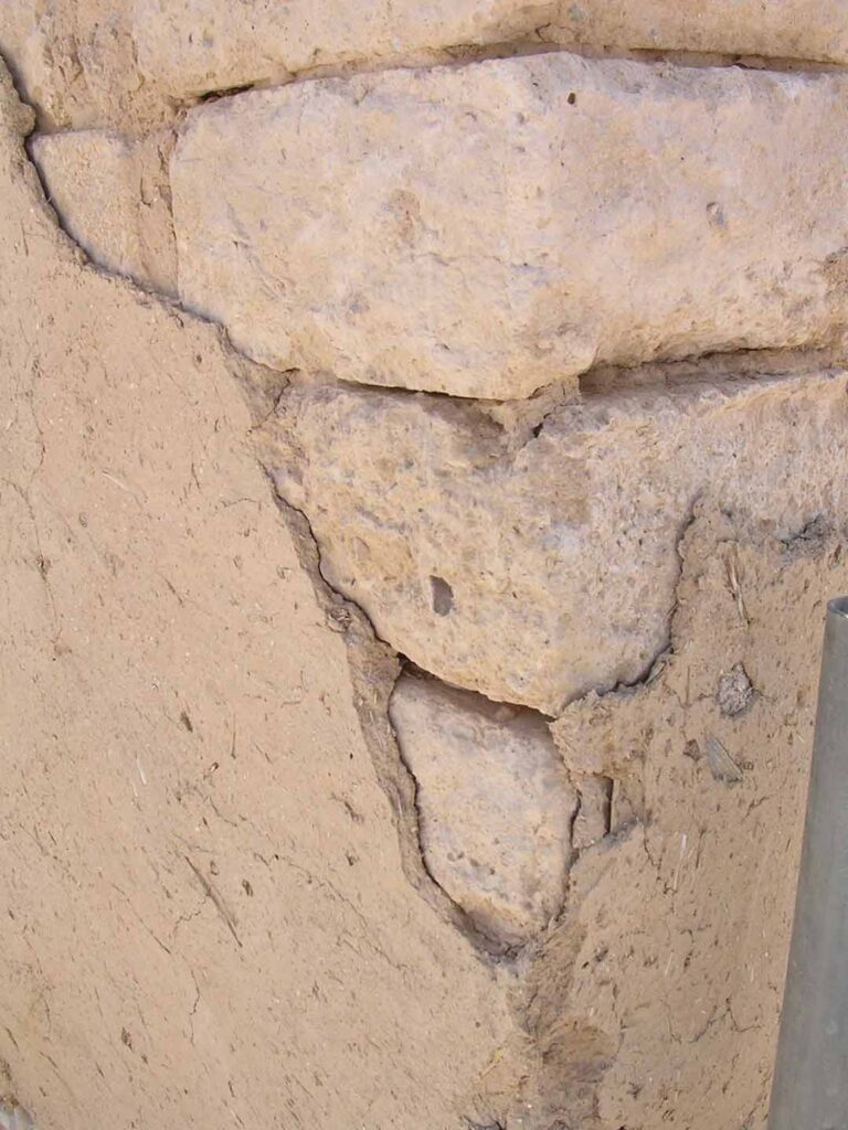
One way to neutralize the effects of this erosion is regularly to “plaster” the surface with a thin layer of a mud mixture. The photo above shows a mud plaster layer (that has partially flaked off) over mud bricks at Beer-sheba (© Dale Manor). This is likely what Ezekiel alludes to in 13:10-15 when he lambasts the Israelites for merely cosmetically covering the structural flaws of the wall with a layer of “whitewash.” Interestingly the LORD threatens to expose their fundamental weakness with the metaphor of a “deluge of rain” and a “stormy wind”—exactly the forces that are most threatening to mud brick structures….
Compare Nephite Cement and Mud Brick Structures in Palestine.
“The Nephites vastly preferred wood to any other building material, and only worked in cement when they were forced to by shortage of timber. Indeed, they refused to settle otherwise good lands in the north if timber for building was lacking (Helaman 3:5). Where they reluctantly settled in unforested areas they continued to “dwell in tents, and in houses of cement,” while they patiently waited for the trees to grow (Helaman 3:9). Since cement must be made of limestone [see. p. 63], there was no lack of stone for building in the north. Why then did they not simply build of stone and forget about the cement and wood? Because, surprising as it may seem, ancient people almost never built of stone. Even when the magnificent “king Noah built many elegant and spacious buildings,” their splendor was that of carved wood and precious metal, like the palace of any great lord of Europe or Asia, with no mention of stone (Mosiah 11:8-9). The Book of Mormon boom cities went up rapidly (Mosiah 23:5; 27:6), while the builders were living in tents. And these were not stone cities: Nephite society was even more dependent on forests than is our own” – Hugh Nibley, An Approach to the Book of Mormon, 2nd Edition, Chapter 29,
Building Materials, Salt Lake City: Deseret Book Co. [1964].

Hugh Nibley stated: “In view of the nature of their civilization one should not be puzzled if the Nephites had left us no ruins at all. People underestimate the capacity of things to disappear, and do not realize that the ancients almost never built of stone. Many a great civilization which has left a notable mark in history and literature has left behind not a single recognizable trace of itself. We must stop looking for the wrong things.” (An Approach to the Book of Mormon, pg. 431)
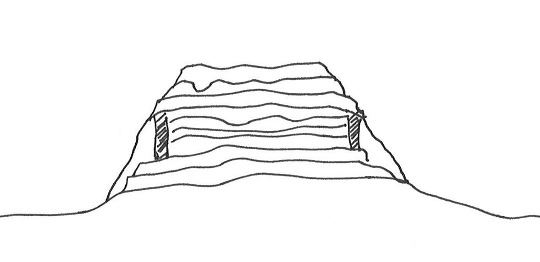
LET ME TELL YOU A TALE OF THE TELS continues “…Because of the limited number of sites where all of these factors converge, eventually another group of people would come along and find 1) water, 2) defensibility, 3) arable land, and 4) access to trade routes. They would therefore build on top of the accumulated debris, thus adding another layer to the site (as well as elevating the site further). Over time, the cycle would repeat itself and eventually numerous layers of occupation would be superimposed on the site.
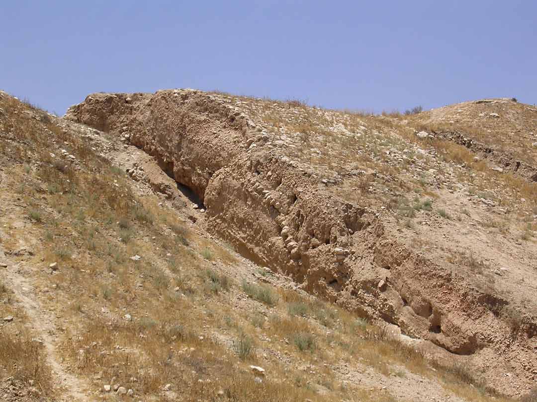
A major factor that contributes to the conical shape were the fortification systems— particularly those of the Middle Bronze Age. These consisted usually of vertical walls with a plastered or cobble slope on the outside—called a glaçis—to curtail a frontal assault on the site (see photo above). These would often serve as a sort of retaining wall to contain the debris inside the town.
Eventually, the elevation might rise above the level of the wall and the debris begin to spill over the wall down the slope, thus creating the fairly uniform slope that tends to characterize so many tels. The passage of time raises the elevation of the sites significantly. Megiddo, for instance, consists of at least twenty layers rising 40-60 meters above the surrounding terrain; Tel Beth-Shemesh has at least nine layers approximately 30 meters above the valley; Lachish has at least eight levels rising over 30 meters above the valley. (A Lachish city wall discovery has been tied to King Solomon’s son.)
These towering settlements could be intimidating, especially when surmounted with fortification walls that often stood another 10 meters or so on top of the slopes.
Excavating Ancient Tels
The task of the archaeologist is to dismantle the layers in reverse order of their deposition, assembling the various finds that are contemporary with each other and interpreting their meaning both chronologically as well as culturally. This effort is not as easy as removing layers from a layer cake because the layers inevitably are uneven and have been disrupted by robbing and pits (think for instance of a child digging into the bottom layer of the cake, which then needs to be filled with icing before the next layer is placed on it). (See the excavation of the tel that confirmed the destruction of biblical Gezer.)

Tels Give Insight to the Biblical Account
Our understanding of the composition and structure of tels might help us better appreciate a point in the episode of the spies who reconnoitered Canaan (Num. 13). The Israelites had come from Egypt where, because of the topographic and ecological nature of the region, tall tels are very rare.5 Neither does the Sinai peninsula have tels because the region will not sustain a large perennial occupation, but is generally the domain of widely scattered migrating pastoralists. Hence, when the spies finally entered Canaan, they encountered these intimidatingly high city platforms surmounted with fortification walls. It is small wonder that they reported that the “people who dwell in the land are strong, and the cities are fortified and very large” (Num. 13:28). Moses, later narrates that the spies’ report had described the fortifications even more dramatically: “The cities are great and fortified up to heaven” (Deut. 1:28). This, along with the other factors mentioned in their report, prompted ten of the spies to lose faith.
Caleb and Joshua did not deny the “truthfulness” of the report (although I doubt they bought into the “grasshopper” simile; cf. Num. 13:33), but for them, faith was more important—they trusted God to sustain them and remove the formidable barriers (Num. 13:30; 14:6-9). A lesson that encourages us to keep thinking!
- 1 Ludwig Koehler and Walter Baumgartner, The Hebrew and English Lexicon of the Old Testament, vol. 4 (Leiden: Brill, 1999), 1735-36.
- 2 Francis Brown, S. R. Driver, and Charles A. Briggs, A Hebrew and English Lexicon of the Old Testament (Oxford: Clarendon, 1907, reprint with corrections 1972), 1068.
- 3 Wright offers a more detailed etymology of the word tel pushing back to Sumerian in the Mesopotamian Valley (123).
- 4 Koehler and Baumgartner, vol. 2 (Leiden: Brill, 1995), 815-16. Zevit, however, argues that the Hebrew word reflects a meaning alluding to some “topographical or geographical feature characteristic” of the site rather than its status as a ruin (see Ziony Zevit, “Archaeological and Literary Stratigraphy in Joshua 7-8.” Bulletin of the American Schools of Oriental Research 251 [1983]: 23-35 [pp. 26-28]).
- 5 Wright says that the use of the word tell in Egypt (e.g., Tell Amarna, Tell Nebesheh, and Tell el-Yehudiyah) is “probably a modern borrowing from western Asia” (123).
Bibliography:
Brown, Francis, S. R. Driver, and Charles A. Briggs, A Hebrew and English Lexicon of the Old Testament. Oxford: Clarendon, 1907, reprint with corrections 1972.
Koehler, Ludwig and Walter Baumgartner, The Hebrew and English Lexicon of the Old Testament, vol. 4. Leiden: Brill, 1999.
Rosen, Arlene Miller. Cities of Clay: The Geoarcheology of Tells. Chicago: University of Chicago, 1986.
Rosen, Arlene Miller. “Tell.” Pp. 163 in The Oxford Encyclopedia of Archaeology in the Near East, vol. 5. Ed. E. M. Myers. New York: Oxford University, 1997.
Wright, G. Ernest. “The Tell: Basic Unit for Reconstructing Complex Societies of the Near East.” Pp. 123-30 in Reconstructing Complex Societies: An Archaeological Colloquium. Ed. C. B. Moore. Bulletin of the American Schools of Oriental Research, Supplement 20. Cambridge, MA: A.S.O.R., 1974.
Yadin, Yigael. The Art of Warfare in Biblical Lands, 2 vols. New York: McGraw-Hill, 1963, pp. 18-19.
Zevit, Ziony, “Archaeological and Literary Stratigraphy in Joshua 7-8.” Bulletin of the American Schools of Oriental Research 251 (1983): 23-35.
TOP PHOTO: The classic tel shape is seen at Tel Keisan in the Akko plain, located about 5 miles from the Mediterranean coast in the Galilee region of Israel. (© Dale Manor)
Source: https://patternsofevidence.com/2020/11/20/biblical-archaeology-tale-of-the-tels/