My good friend and artist Clark Kelley Price, painted a beautiful rendition of Moroni fortifying the Nephite Lands as described in Alma 50. Clark read this chapter over and over trying to make this fortification as realistic as possible as it would have been in the Untied States of America. https://clarkkelleyprice.com/
I place this fortification somewhere near Pittsburgh, PA or Moundsville, WV as those locations would make a good fort along the Ohio/Allegheny Rivers protection the Nephites with the rivers at their back and the East Wilderness in front as they began pushing the Lamanites east and south. (Alma 50:9) You will understand better as you read this blog.
Alma Chapter 50 I believe is one of the best sources for geography of the Book of Mormon in North America. I love creating maps as I read the text. Everything comes alive for me and I hope it does for you as well.

ALMA CHAPTER 50
Moroni fortifies the lands of the Nephites—They build many new cities—Wars and destructions befell the Nephites in the days of their wickedness and abominations—Morianton and his dissenters are defeated by Teancum—Nephihah dies, and his son Pahoran fills the judgment seat. About 72–67 B.C.
1 And now it came to pass that Moroni did not stop making preparations for war, or to defend his people against the Lamanites; for he caused that his armies should commence in the commencement of the twentieth year of the reign of the judges, that they should commence in digging up heaps of earth round about all the cities, throughout all the land which was possessed by the Nephites.
2 And upon the top of these ridges of earth he caused that there should be timbers, yea, works of timbers built up to the height of a man, round about the cities.
3 And he caused that upon those works of timbers there should be a frame of pickets built upon the timbers round about; and they were strong and high.
4 And he caused towers to be erected that overlooked those works of pickets, and he caused places of security to be built upon those towers, that the stones and the arrows of the Lamanites could not hurt them.
5 And they were prepared that they could cast stones from the top thereof, according to their pleasure and their strength, and slay him who should attempt to approach near the walls of the city.
6 Thus Moroni did prepare strongholds against the coming of their enemies, round about every city in all the land.
If Moroni prepared strongholds in every city in all the land, can you imagine how many that would be? Not 10 or even 100, I would guess hundreds of strongholds. Here is a good quote concerning this number. “ON THE SOUTH SIDE OF LAKE ERIE, THERE IS A SERIES OF OLD FORTIFICATIONS, RUNNING FROM THE CATTARAUGUS CREEK TO THE PENNSYLVANIA LINE, A DISTANCE OF FIFTY MILES; some are two, three, and four miles apart, and some within half a mile. Some contain five acres… Still further south, there is said to be another chain of forts running parallel with the former, and about the same distance from them as those are from the lake… Whether the nations, which possessed our western country before the Iroquois, had erected those fortifications to protect them against their invaders, or whether they were made by anterior inhabitants, are mysteries which cannot be penetrated by human sagacity; nor can I pretend to decide whether the Eries or their predecessors raised the works of defense in their territory; but I am persuaded that enough has been said to demonstrate the existence of a vast population, settled in towns, defended by forts, cultivating agriculture, and more advanced in civilization than the nations which have inhabited the same countries since the European discovery.” Clinton, De Witt. A Memoir On The Antiquities Of The Western Parts Of The State Of New-York (Note: Remember not even the Native Americans know who built these fortifications, meaning a much earlier people than the Native Americans (perhaps the Hopewell or Nephite people) built these strongholds.
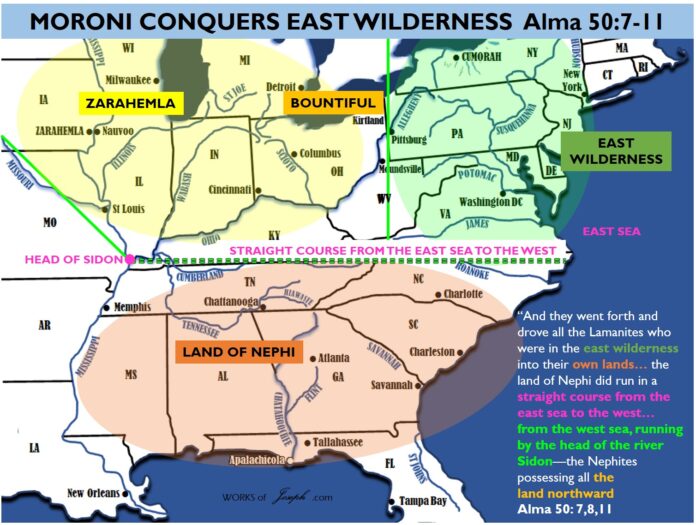
The bright green line in the map below represents a day for a Nephite and the Narrow Passage spoken of in Mormon 2:29. This is the “SERIES OF OLD FORTIFICATIONS, RUNNING FROM THE CATTARAUGUS CREEK TO THE PENNSYLVANIA LINE, A DISTANCE OF FIFTY MILES“, spoken of in the above quote. This 44 miles from the Land Northward at Irving, NY to the Land Southward to Salamanca, NY needed to be protected. (See Moroni’s America page 241 quoted below).
“What is Mormon’s frame of reference here? (Mormon 2:29) He is writing from his own homeland, where he grew up. It is the same perspective he had when, as a boy, his father took him “into the land southward, even to the land of Zarahemla” (Mormon 1:6). The Lamanites received all the land southward.
This is the only mention in the text of a “narrow passage.” It is not a neck or even a pass; it may not be a natural feature at all. A passage is a “road; way; avenue; a place where men or things may pass or be conveyed.”[i]
As part of a treaty, it appears to be an agreed-upon route or way—a corridor—through which access between the two lands would be permitted.
The narrow passage specified in this treaty reminds me of the narrow passages, also established by treaty, between West Germany and Berlin during the cold war. One could travel within these passages, but veering outside could mean arrest and imprisonment.
In terms of real world geography, there are numerous valleys, long narrow rises and hills, and other features in western New York that could have served as the narrow passage defined by this treaty. Presumably this narrow passage would give access to the river system that led into the land southward—the very river system Mormon’s father took him on when he was eleven years old.” Moroni’s America page 241-242.
[i] “Passage,” Webster’s 1828 Dictionary, http://bit.ly/Moroni113.
Read my blog here about the various necks of land in the Book of Mormon.

The quote from De Witt Clinton above, I use often which I believe is describing the Narrow Passage in the Book of Mormon in Mormon 2:29 which says, “And the Lamanites did give unto us the land northward, yea, even to the narrow passage which led into the land southward. And we did give unto the Lamanites all the land southward.”
We now continue with Alma Chapter 50 verses 7-11 below:

FOLLOW COLORS ON MAP ABOVE AS YOU READ VERSE 7-11 BELOW.

12 Thus Moroni, with his armies, which did increase daily because of the assurance of protection which his works did bring forth unto them, did seek to cut off the strength and the power of the Lamanites from off the lands of their possessions, that they should have no power upon the lands of their possession.
13 And it came to pass that the Nephites began the foundation of a city, and they called the name of the city Moroni; and it was by the east sea; and it was on the south by the line of the possessions of the Lamanites.

14 And they also began a foundation for a city between the city of Moroni and the city of Aaron, joining the borders of Aaron and Moroni; and they called the name of the city, or the land, Nephihah.
15 And they also began in that same year to build many cities on the north, one in a particular manner which they called Lehi, which was in the north by the borders of the seashore.
16 And thus ended the twentieth year.


In the map above there are some very interesting things. In Alma 50 the main border between the Lamanites and the Nephites is the light blue rivers above, the Ohio and the Allegheny. In verse 8 is says, “And the land of Nephi did run in a straight course from the east sea to the west.” Clearly the East Sea is represented by the Atlantic Ocean. The words “to the west” could represent and border or barrier along the Ohio River.
Notice above that the straight course would imply a common latitude and there are many cities on the East Sea that match up with cities on the Ohio River. In my opinion the most likely straight course would be from the Head of the river Sidon (confluence of the Ohio and Mississippi rivers) with the city of Norfolk, VA which is a strait course both being about 37 degrees latitude.
As you read in verse 13 above it says, “And it came to pass that the Nephites began the foundation of a city, and they called the name of the city Moroni; and it was by the east sea; and it was on the south by the line of the possessions of the Lamanites. Where is the line of possessions of the Lamanites? At that 37 degree latitude or the 38 degrees of Washington DC and Huntington WV or Moroni could be from Philadelphia to Moundsville at nearly 40 degrees latitude.
I have reasoned that wouldn’t it be fairly cool if the ancient city of Moroni was either Philadelphia, Baltimore, Washington DC or Norfolk? I have done some wonderful research around the Washington DC area to see what signs of the Hopewell people we could find. Amazingly there are many mounds and sites that date to the time of the verses in Alma 50 which would be around 73 BC. See map below.

Also in verse 14 above it says, “And they also began a foundation for a city between the city of Moroni and the city of Aaron, joining the borders of Aaron and Moroni; and they called the name of the city, or the land, Nephihah.” If the city Moroni that “was by the east sea; and it was on the south by the line of the possessions of the Lamanites” (verse 13), if we find that line of the Lamanite possessions which is the same as the straight course line, we could find the ancient city of Moroni and the Land of Nephihah which would be north of Moroni.


I have overloaded you with maps in this blog. Unless you are willing to follow the rivers, artifacts, geology, terrain, text, and all evidence, it will be difficult for you to find secondary evidence for the Book of Mormon. Each map created here has a specific purpose and I challenge you to read for yourself the text of the Book of Mormon and I believe some of this geography will begin to make sense to you. Please don’t get caught up in the maps however. Read by the Spirit and the Lord will guide you in finding truth of whatever you seek.


