The so-called Two Cumorah Mesoamerica geography theory for The Book of Mormon was created in 1917 by a member of The Reorganized Church of Jesus Christ of Latter-day Saints (The RLDS Church) named Louis E. Hills.
He “prepared a copyrighted Book of Mormon map and … offered them to the (RLDS) Church.” They were rejected. All his books and maps were copyrighted in his name. The copyrights have expired, his works are in the Public Domain, anyone can now resell his maps and ideas.


The map and the idea of geographically restricting The Book of Mormon to Mesoamerica (a word never used by L.E. Hills, but a modern-day usage for “Central America,” “Meso” meaning “Middle” as in Mesopotamia) were later rejected by The RLDS First Presidency in 1921 and 1923. This history is clearly laid out in The Saints’ Herald as noted in my previous three posts here at BOFM.BLOG.
Yet this fantasy map is being promoted today by a cult of its promoters who are members of The Church of Jesus Christ of Latter-day Saints as well as members of The RLDS Church, now called Community of Christ and Restoration Branch.
Despite L.E. Hills’ ideas being rejected by the RLDS Leadership and by a RLDS Church-appointed committee created specifically to review his ideas, Louis E. Hills continued to promote and lecture on his creation from 1917 to 1923 and until his death in 1925.
Notice how L.E. Hills spent 18 hours and one evening presenting evidence before the Committee. Then 15 hours by a member named F.F. Wipper, representing the former official RLDS Church-approved Archaeological Committee, which had its own hemispheric maps. These two men were later involved AGAIN in a PUBLIC debate over the two maps, in 1924.
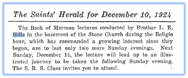
But let’s first look at the entries in The Saint’s Herald about L.E. Hills, that preceded the 1924 debate.

Notice that despite the rejection by The Committee and The RLDS First Presidency, L.E. Hills continued to spend his time and use the resources of his Church to promote his ideas throughout the rest of 1923.


I find this absolutely astounding, that a member of The RLDS Church, and a member of its First Quorum of Seventy, would use his Church-appointed position to continue to promote and lecture on his personally-owned private ideas, using the resources of his Church for his own benefit in attempt to convince members of his Church, despite their President having rejected his ideas just months earlier. The Stone Church mentioned, is directly across the street from the New Jerusalem Temple Lot, ironically, a geographical marker for The Book of Mormon.
In my opinion, this is being mirrored today in The Church of Jesus Christ of Latter-day Saints as recently as BYU Education Week and in Church Book of Mormon videos due to the influence of so-called LDS Mesoamerica Book of Mormon “scholars,” who appear to be ignorant of the origin of this geography theory. Laughably, many have wasted time acquiring advanced university degrees on Mesoamerica studies to promote themselves as credentialed experts, all based on a rejected-fantasy from some 100 years earlier.
Then in October 1923, L.E. Hills and 19 other men, were released from the First and Second Quorums of Seventy, “with no reflection whatever upon their character or moral standing.”

In 1924, The Saints’ Herald continues to report on the known activities of L.E. Hills, promoting his Two Cumorah Mesoamerica or Central America geography theory.
Then in May 1924, The Saints’ Herald announces the public debate of the two maps.
1924

Note here, the use of the idea of “THE INTERNAL EVIDENCES of The Book of Mormon,” used by L.E. Hills, a phrase used liberally by today’s so-called LDS Mesoamerica Book of Mormon scholars, to promote L.E. Hills’ now expired copyrighted Book of Mormon geography theory.


Notice how the debate, coined “Friendly Discussion,” was initially planned for the nearby Campus of Graceland College then moved to The Stone Church, for eight sessions of two hours each, beginning April 19, 1924, the location again, is located directly across the street north of The New Jerusalem Temple Lot, a geographical marker for The Book of Mormon.
This debate obviously vaulted L.E. Hills’ ideas into the minds of the membership of The RLDS Church, an astute but deceptive move on his part, in my opinion. This foreshadowed the same idea by those who published this geography theory in the Ensign Magazine in the 1980s and is now being promoted, debated and argued among members of The Church of Jesus Christ of Latter-day Saints.
The following document was obtained from the Community of Christ Library and Archives.
This document or program, is 33 pages in length. Many of its pages are blank which were to be used for writing notes by those in attendance.
The debate, as you can see, ran from May 20 to May 30, 1924. Amazing.


Proposition One, for the debate, has F.F. Wipper defending the hemispheric maps and published report of the RLDS Committee on American Archaeology. You can see those reports and its six maps, on my blog here. I’ve included Map No. 5, below.
(Page 4)


Follows are blank pages titled “REMARKS” with dates of each debate referring back to page 4, allowing those in attendance to take notes on these blank pages, two for each day, as they listened to the “Friendly Discussion.”
Pages 5-11, blank except for headings:
Proposition Two, was printed on page 12.
Then the following blank seven pages, the same pattern above with the dates through to May 30.

This is that 1923 copyrighted map mentioned on page 12 of the Program, which L.E. Hills created.

Pages 13 – 19, blank except for some headings
Page 20 notes the “Participants.” The reference to F.F. Wipper of the “L.D.S.” Church is a reference to the RLDS Church, since Wipper was mentioned in The Saints’ Herald as presenting evidence to the aforementioned Book of Mormon Committee in 1923.
Page 21 notes that collections were taken by those in attendance to defray the costs of the meeting.
The remaining pages of the program, not included here, contained the lyrics to hymns, apparently sung during the Friendly Discussion, to help avoid the spirit of contention.


The Saint’s Herald for the remaining year of 1924 has these entries for L.E. Hills who continued his lectures and promotion of his ideas.
1924 continued
This wedding announcement of L.E. Hills’ daughter, her second as she was a widow at the time, notes the home address of L.E. Hills. (The death of Louise Hill’s first husband is mentioned earlier in The Saints’ Herald.)
Thus, you now know the location and address where the so-called Two-Cumorah Mesoamerica geography theory was created and the date it was introduced to a RLDS Priesthood meeting:
201 South Willis Avenue, Independence, Missouri
Thursday, April 12, 1917, 10:45 a.m.
These are the next entries in The Saints’ Herald to the end of 1924. Notice that L.E. Hills placed an advertisement in the Herald for his third book, “New Light on American Archaeology,” in the last edition of December 1924 and in the first January 1925 edition of the Herald.
“New Light” is Hills’ Two-Cumorah Mesoamerica idea and a reference to the past official RLDS Committee on American Archaeology which produced a report and the (also false) hemispheric maps for The Book of Mormon as far back as the 1900s, mentioned in my first blog entry here at BofM.BLOG.


1925

Note that his third book, “New Light on American Archaeology” consists of thirteen lectures by L.E. Hills. Price, $1.00. There is nothing complicated, sophisticated or academic about these books. L.E. Hills was employed as a Railroad Conductor, the likely reason why our modern-day LDS Mesoamerica “so-called” Scholars, have been hiding the source. They’re likely embarrassed by it.
For example, L.E. Hills in his 1924 book of lectures, referenced the Giant Ground Sloth of South America in connection to the Isthmus of Panama, as evidence for the location of Book of Mormon geography. Our ridiculous LDS Book of Mormon so-called “Meso-scholars” today, or whatever they marked their foreheads as, seem intent on embarrassing The Church of Jesus Christ of Latter-day Saints, for their own aggrandizement and personal gain without knowing the source of what they promote.
I can only imagine them standing at the pulpit of their Chapels blubbering and blabbering on about their testimonies of the truthfulness of this geography fantasy-land, revealed to them by The Holy Spirit, after receiving accolades, payments and donations via PayPal buttons on their websites, from their lectures, articles and books about it. What a bunch of silly sods.
This book can be found, scanned on line by Google, at HathiTrust, along with L.E. Hills’ older books. I recently purchased through Amazon and have in my possession, a physical copy of “New Light on American Archaeology.” It’s approximately 7.5 x 5.5 inches and about one-half inch thick. It stinks of paper mold or mildew, due to age.
1918: A SHORT WORK ON THE POPOL VUH AND THE TRADITIONAL HISTORY OF THE ANCIENT AMERICANS BY IXT-LIL-XOCHITL
1919: HISTORICAL DATA FROM Ancient Records and Ruins OF Mexico AND Central America
1924: NEW LIGHT ON AMERICAN ARCHAEOLOGY
There are a few more entries in the 1925 Saints’ Herald, then the announcement of the death of L.E. Hills.


Then these announcements of the death of L.E. Hills on June 19, 1925.


The automobile skidded on a wet street, meaning there were witnesses to this tragic event. A typical automobile, in 1925:
Then this last entry in 1925, where on the same page, the RLDS Herald reported other snippets from scientific and nature magazines that showed evidence for The Book of Mormon, including those which support a Heartland Geography Theory.

The image of the very next paragraph in The Saints’ Herald, referring to the Mound Builders in the State of Ohio. Page 1337 of The December 16. 1925, Saints’ Herald:

This is the history of L.E. Hills and of his, today so-called, Two Cumorah Mesoamerica geography theory, which restricts The Book of Mormon to Central America, found in The Saints’ Herald.
It’s a complete fantasy. It’s not true.
It was rejected by the RLDS Church Leadership in 1921 and in 1923, after being reviewed privately by a RLDS Church Committee specifically appointed by RLDS Leadership to discuss it, as well as debated publicly among members of The RLDS Church in 1924 in their primary meeting location, The Stone Church, across the street from a geographical marker for The Book of Mormon, in Independence, Missouri, The New Jerusalem Temple Lot. I can’t repeat that enough times. See the Tenth Article of Faith, written by The Prophet Joseph Smith who translated The Book of Mormon by the gift and power of God, through the means of the Urim and Thummim specifically provided for the translation of the keystone of our religion, the last leaf of the plates being the Title Page of The Book of Mormon.
The only thing that stopped L.E. Hills was his death. He was hit by an automobile, which is ironic, since at the age of 15, he was a bugler for General George Armstrong Custer in the 1873 expedition to the Yellowstone to protect a survey party for a route for the now Northern Transcontinental Railroad and during so, was involved in an Indian battle led by Chief Sitting Bull, per his own autobiography, which can be found here on my blog.
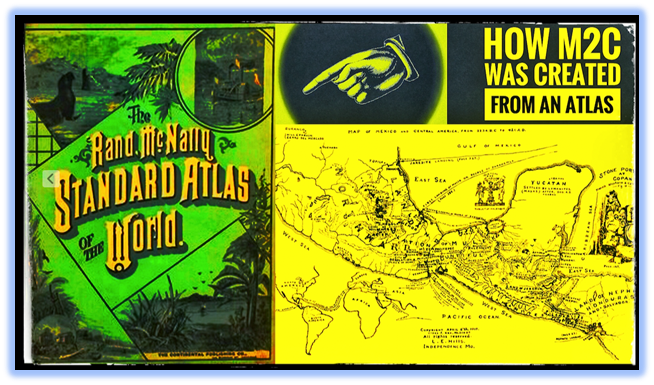
NEXT: How M2C was created from an Atlas. I will share with you a document written by L.E. Hills in his own words, explaining how he created his Book of Mormon geography theory, restricting The Book of Mormon, including the “original” Hill Cumorah, to Mesoamerica.


Stephen Reed, Mesa, Arizona


